![]()
Corserine
814m (2672ft)
The Galloway Hills, The Southern Uplands, Dumfries and Galloway, Scotland
The summit of Corserine is marked by an Ordnance Survey Trig Point.

Not familiar with this top?
   |
|---|
Vital Statistics:
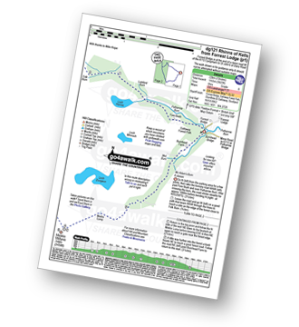
| Length: | 13ml (22km) |
|---|---|
| Ascent: | 3,823ft (1,165m) |
| Time: | 8 hrs |
| Grade: |  (Hard) (Hard) |
Route Summary:
Forrest Lodge - Galloway Forest Park - Fore Bush - Polharrow Burn - Lumford Burn - Craignelden - Craigrine - Corserine - Carlin's Cairn - Corserine - Millfire - Milldown - Rhinns of Kells - Meikle Millyea - Meikle Lump - Burnhead - Forrest Lodge - Galloway Forest Park.
See Corserine and the surrounding tops on our free-to-access 'Google Style' Peak Bagging Maps:
The Galloway Forest Hills area of Scottish Region 26: The Southern Uplands
Less data - quicker to download
Scottish Region 26: The Southern Uplands
Less data - quicker to download
A go4awalk.com downloadable Peak Bagging Map in PDF format featuring Corserine should be available soon.
You can find Corserine & all the walks that climb it on these unique free-to-access Interactive Walk Planning Maps:
1:25,000 scale OS Explorer Map (orange/yellow covers):
1:50,000 scale OS Landranger Map (pink/magenta covers):
 Fellow go4awalkers who have already walked, climbed, summited & bagged Corserine
Trevor Williams has walked, climbed & bagged Corserine.
To add (or remove) your name and experiences on this page - Log On and edit your Personal Mountain Bagging Record
Send us your photographs and pictures on, of, or from Corserine
If you would like to add your walk photographs and pictures to this page, please send them as email attachments (configured for any computer) along with your name to:
and we shall do our best to publish them.
(Guide Resolution = 300dpi. At least = 660pixels (wide) x 440 pixels (high).)

You can also submit photos via our Facebook Page.
NB. Please indicate where each photo was taken and whether you wish us to credit your photos with a Username or your First Name/Last Name.
Not familiar with this top?