![]()
Beinn a' Chroin (East Top)
940m (3085ft)
The Crianlarich Hills, Loch Lomond and The Trossachs to Loch Tay, Loch Lomond and The Trossochs, Stirlingshire, Scotland

Not familiar with this top?
   |
|---|
Vital Statistics:
| Length: | 9.5ml (15km) |
|---|---|
| Ascent: | 3,673ft (1,119m) |
| Time: | 7.25hrs |
| Grade: |  (Hard) (Hard) |
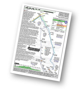
Route Summary:
Glen Falloch - River Falloch - Sron Garbh - Coire Elch - Twistin Hill - The Castle - An Caisteal (Glen Falloch) - Bealach Buidhe - Beinn a' Chroin - Beinn a' Chroin (East Top) - River Falloch - Core Earb - Glen Falloch
See Beinn a' Chroin (East Top) and the surrounding tops on our free-to-access 'Google Style' Peak Bagging Maps:
The Crianlarich Hills area of Scottish Region 1: The Firth of Clyde to Strath Tay
Less data - quicker to download
Scottish Region 1: Loch Lomond and The Trossachs to Loch Tay
Less data - quicker to download
A go4awalk.com downloadable Peak Bagging Map in PDF format featuring Beinn a' Chroin (East Top) should be available soon.
You can find Beinn a' Chroin (East Top) & all the walks that climb it on these unique free-to-access Interactive Walk Planning Maps:
1:25,000 scale OS Explorer Map (orange/yellow covers):
1:50,000 scale OS Landranger Maps (pink/magenta covers):
 Fellow go4awalkers who have already walked, climbed, summited & bagged Beinn a' Chroin (East Top)
Andrew Edwards walked up it on October 12th, 2015 [from/via/route] A82 car park [with] Myself [weather] Sunny - Nice view looking back on what u have achieved in the day
Ron Blundell and Mark Davidson have both walked, climbed & bagged Beinn a' Chroin (East Top).
To add (or remove) your name and experiences on this page - Log On and edit your Personal Mountain Bagging Record
Send us your photographs and pictures on, of, or from Beinn a' Chroin (East Top)
If you would like to add your walk photographs and pictures to this page, please send them as email attachments (configured for any computer) along with your name to:
and we shall do our best to publish them.
(Guide Resolution = 300dpi. At least = 660pixels (wide) x 440 pixels (high).)

You can also submit photos via our Facebook Page.
NB. Please indicate where each photo was taken and whether you wish us to credit your photos with a Username or your First Name/Last Name.
Not familiar with this top?