![]()
Craig Cerrig-gleisiad
629m (2064ft)
The Brecon Beacons Area, The Brecon Beacons, Powys, Wales
Craig Cerrig-gleisiad means 'Blue Stone Rock' in Welsh and is pronounced 'kryg-kerig-gl-ay-si-ad'.
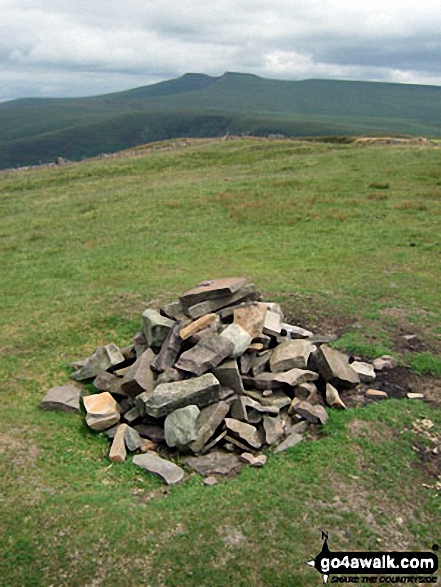
The summit of Craig Cerrig-gleisiad is marked by a cairn.
Not familiar with this top?
   |
|---|
Vital Statistics:
| Length: | 3.75ml (6km) |
|---|---|
| Ascent: | 1,099ft (335m) |
| Time: | 2½ hrs |
| Grade: |  (Easy) (Easy) |
Route Summary:
A470 Nr Llwyn-y-celyn Youth Hostel - Libanus - Craig Cerrig-gleisiad - Fan Frynych - Twyn Dylluan-ddu - A470.
|
|---|
Vital Statistics:
| Length: | 7.5ml (12km) |
|---|---|
| Ascent: | 1,736ft (529m) |
| Time: | 4½ hrs |
| Grade: |  (Moderate) (Moderate) |
Route Summary:
A470 Nr Llwyn-y-celyn Youth Hostel - Libanus - Craig Cerrig-gleisiad - Fan Frynych - Nant Cwm-du - Craig Cwm-du - Pont Blaen-Cwm-du - Coed y Fan - Twyn Dylluan-ddu - A470.
|
|---|
Vital Statistics:
| Length: | 8.25ml (13km) |
|---|---|
| Ascent: | 2,009ft (612m) |
| Time: | 5 hrs |
| Grade: |  (Moderate) (Moderate) |
Route Summary:
A470 Nr Llwyn-y-celyn Youth Hostel - Libanus - Twyn Dylluan-ddu - Fan Frynych - Craig Cerrig-gleisiad - Rhos Dringarth - Gorllwn - Fan Fawr - Bryn Du - The Storey Arms Outdoor Centre - The Taff Trail - A470.
|
|---|
Vital Statistics:
| Length: | 9.75ml (15.5km) |
|---|---|
| Ascent: | 2,402ft (732m) |
| Time: | 6 hrs |
| Grade: | (Moderate) |
Route Summary:
Blaen Llia Picnic Area - Fan Llia - Fan Dringarth - Cefn Perfedd - Craig Cwm-du - Rhos Dringarth - Craig Cerrig-gleisiad - Gorllwn - Fan Fawr - Ystradfellte Reservoir - Cwm Dringarth - Blaen Llia.
|
|---|
Vital Statistics:
| Length: | 10.5ml (17km) |
|---|---|
| Ascent: | 1,569ft (478m) |
| Time: | 5½ hrs |
| Grade: | (Moderate) |
Route Summary:
Blaen Llia Picnic Area - Fan Llia - Fan Dringarth - Cefn Perfedd - Craig Cwm-du - Rhos Dringarth - Craig Cerrig-gleisiad - Fan Frynych - Nant Cwm-du - Pont Blaen Cwm-du - Sran Heln Roman Road - Maen Llia Standing Stone - Rhyd Uchaf - Blaen Llia.
See Craig Cerrig-gleisiad and the surrounding tops on our free-to-access 'Google Style' Peak Bagging Maps:
The Brecon Beacons Area of Bannau Brycheiniog (The Brecon Beacons National Park)
Less data - quicker to download
The Whole of Bannau Brycheiniog (The Brecon Beacons National Park)
More data - might take a little longer to download
See Craig Cerrig-gleisiad and the surrounding tops on our downloadable Peak Bagging Map in PDF format:

NB: Whether you print off a copy or download it to your phone, this PDF Peak Baggers' Map might prove incredibly useful when your are up there on the tops and you cannot get a phone signal.
You can find Craig Cerrig-gleisiad & all the walks that climb it on these unique free-to-access Interactive Walk Planning Maps:
1:25,000 scale OS Explorer Map (orange/yellow covers):
1:50,000 scale OS Landranger Map (pink/magenta covers):
 Fellow go4awalkers who have already walked, climbed, summited & bagged Craig Cerrig-gleisiad
Melfyn Parry walked up it on September 12th, 2025 [from/via/route] Followed route PO112 & then rather than tab down the Taffs Trail I headed up to Y Gyrn (to bag another Nuttall) & then rejoined the Taffs Trail lower down to finish the route this extended the walk to 10 miles. [with] On my own [weather] Only one spell of heavy rain otherwise a dry, breezy day.
Donovan Suddell climbed it on August 27th, 2024 [from/via/route] Libanus [with] solo [weather] Dry, high cloud, clear summits, Gusty
Paul Roddam bagged it on January 21st, 2023 [from/via/route] Pen Y Fan Car Park [with] Solo [weather] Cold, sunny
Helen Howarth hiked it on June 26th, 2021 [from/via/route] From A470 [with] Leila x [weather] Foggy & drizzly rain - Early morning walk
Sion Britton summited on November 22nd, 2020 [from/via/route] Fan Llia to Fan Fawr Horseshoe. [with] Rhiannon, Catrin, Mikey, Angharad, Ann, Dewi a Gwen. [weather] Dry, cold & boggy.
Toby Norman conquered it on July 28th, 2018 [with] Woots, Jay, Odette, Sarah, Steve
Mark Davidson scaled it on July 9th, 2009 [from/via/route] go4awalk po102:- Blaen Llia Picnic Area, Fan Llia, Fan Dringarth, Cefn Perfedd, Craig Cwm-du, Rhos Dringarth, Craig Cerrig-gleisiad, Fan Frynych, Nant Cwm-du, Pont Blaen Cwm-du, Sran Heln Roman Road, Maen Llia Standing Stone, Rhyd Uchaf, Blaen Llia. [with] Alone [weather] Bit dull but quiet warm
Andrew Joss walked up it on September 1st, 2017 [from/via/route] Pont Ar Daf car park [with] Barbara [weather] Sunny
Bleddyn Rhys climbed it on June 4th, 2016 [from/via/route] A470 Storey Arms - Eto 29th Ebrill 2017 wrth fynd o Libanus i Craig y Nos.
Neil Hake bagged it on September 5th, 2016 [weather] fogy & wet
To add (or remove) your name and experiences on this page - Log On and edit your Personal Mountain Bagging Record
. . . [see more walk reports]
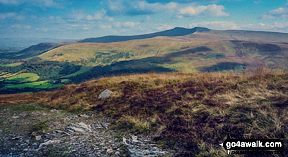
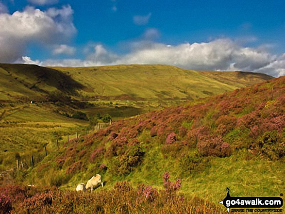
More Photographs & Pictures of views from, on or of Craig Cerrig-gleisiad
Send us your photographs and pictures on, of, or from Craig Cerrig-gleisiad
If you would like to add your walk photographs and pictures to this page, please send them as email attachments (configured for any computer) along with your name to:
and we shall do our best to publish them.
(Guide Resolution = 300dpi. At least = 660pixels (wide) x 440 pixels (high).)

You can also submit photos via our Facebook Page.
NB. Please indicate where each photo was taken and whether you wish us to credit your photos with a Username or your First Name/Last Name.
Not familiar with this top?