
![]()
Yr Aran
747m (2452ft)
The Snowdon Area, Snowdonia, Gwynedd, Wales
Yr Aran means 'The Mountain' in Welsh and is pronounced 'ur-a-ran'.
The summit of Yr Aran is marked by a cairn.
Not familiar with this top?
   |
|---|
Vital Statistics:
| Length: | 9ml (14.5km) |
|---|---|
| Ascent: | 3,982ft (1,214m) |
| Time: | 7½ hrs |
| Grade: |  (Hard) (Hard) |
Route Summary:
Rhyd-Ddu - Rhyd-Ddu Path - Pen Ar Lon - Bwlch Main - Snowdon (Yr Wyddfa) - Allt Maenderyn - Bwlch Cwm Llan - Yr Aran - Pen Ar Lon - Rhyd-Ddu
|
|---|
Vital Statistics:
| Length: | 9.5ml (14.5km) |
|---|---|
| Ascent: | 4,517ft (1,377m) |
| Time: | 8 hrs |
| Grade: | (Hard) |
Route Summary:
Nantgwynant - Bethania - Castell - Gladstone Rock - The Watkin Path - Bwlch Ciliau - Bwlch y Saethau - The Scree Path - Snowdon (Yr Wyddfa) - Rydd Ddu Path - Clogwyn Du - Allt Maenderyn - Yr Aran - Clogwyn Birth - Nantgwynant
See Yr Aran and the surrounding tops on our free-to-access 'Google Style' Peak Bagging Maps:
The Snowdon Area of Snowdonia National Park
Less data - quicker to download
The Whole of Snowdonia National Park
More data - might take a little longer to download
See Yr Aran and the surrounding tops on our downloadable Peak Bagging Map in PDF format:

NB: Whether you print off a copy or download it to your phone, this PDF Peak Baggers' Map might prove incredibly useful when your are up there on the tops and you cannot get a phone signal.
You can find Yr Aran & all the walks that climb it on these unique free-to-access Interactive Walk Planning Maps:
1:25,000 scale OS Explorer Map (orange/yellow covers):
1:50,000 scale OS Landranger Map (pink/magenta covers):
 Fellow go4awalkers who have already walked, climbed, summited & bagged Yr Aran
Donovan Suddell walked up Yr Aran on October 27th, 2024 [from/via/route] Watkin Path [with] wife [weather] clear & dry
Daniel Moran climbed Yr Aran on May 27th, 2024 [from/via/route] Caravan [with] Frankie [weather] After a wet morning set off at 1 - No path for the middle section, misty on top, carry Frankie over the wall
Melfyn Parry bagged Yr Aran on November 21st, 2021 [from/via/route] From Caffi Gwynant, up Watkyn path to SH620520 & then turn left & follow path on to summit. [with] PRC - Descend after heading over to Craig Wen
Sion Britton hiked Yr Aran on April 22nd, 2019 [from/via/route] Cerdded o Rhyd-Ddu [with] Rhiannon [weather] Braf
Andy Buxton summited Yr Aran during August, 1964 [from/via/route] Up Watkin Path; down South Ridge of Snowdon & returnd to Plas Gwynant [with] Dad - Watkin Path is definitely the WORST way up Snowdon.
Angela Moroney conquered Yr Aran during 2011 - 2017 3PEAKS
Wynne Roberts scaled Yr Aran on June 15th, 2019 [from/via/route] Watkin Pass [with] Gareth [weather] Sunny spells. Breezy - Came back to campsite at 10:45pm
Bleddyn Rhys walked up Yr Aran on December 28th, 2014 [from/via/route] Fynnu'r Watkin path o dyffryn Gwynant ac i lawr i Beddgelert [with] gyda Siwan Rhys! [weather] Eira fresh tew dan draed ac awyr las las braf. Haul ar ein gwynebau! Tywydd 'alpine' go iawn! - Diwrnod bendigedig!
Christina Lander climbed Yr Aran on April 19th, 2018 [from/via/route] Pont Bethania - Watkin Path - Snowdon - Allt Maenderyn - Yr Aran - Pont Bethania [with] Dick [weather] Cloudy on the tops, but a very warm sunny day a bit lower down
Craig Lewis bagged Yr Aran on September 30th, 2016 - 30.9.16 - watkins path 7.10.17 - up by Pyg down by Miners (3Peaks)
To add (or remove) your name and experiences on this page - Log On and edit your Personal Mountain Bagging Record
. . . [see more walk reports]
More Photographs & Pictures of views from, on or of Yr Aran
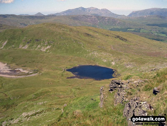
Llynnau Barlwyd (foreground), Moel Farlwyd (midground left), Yr Aran (pointed peak above Moel Farlwyd), Mount Snowdon (Yr Wyddfa) & Y Lliwedd from Moel Penamnen
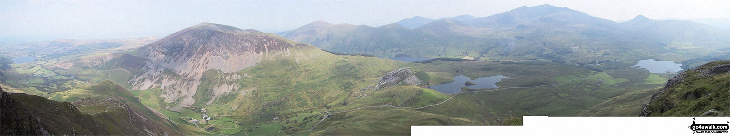
Mynydd Mawr (Llyn Cwellyn), Y Garn (Moel Hebog), The Nantlle Ridge and Mynydd Drws-y-coed from Trum y Ddysgl - with The Snowdon Massif (Moel Eilio (Llanberis), Foel Gron, Moel Cynghorion, Garnedd Ugain (Crib y Ddysgl), Snowdon (Yr Wyddfa), Y Lliwedd and Yr Aran) forming the backdrop
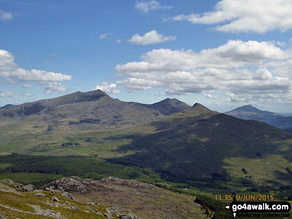
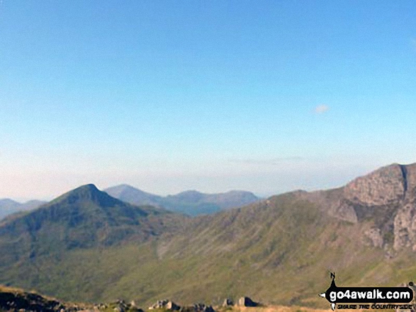
Snowdon (Yr Wyddfa) (left), Yr Aran and Carnedd Moel Siabod (right) from the summit of Moel Lefn
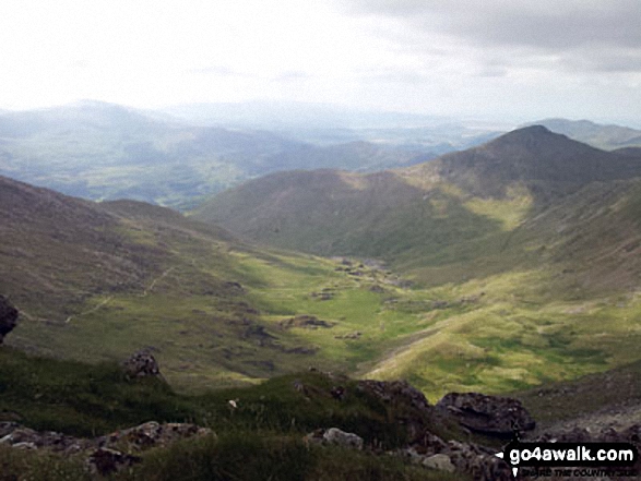
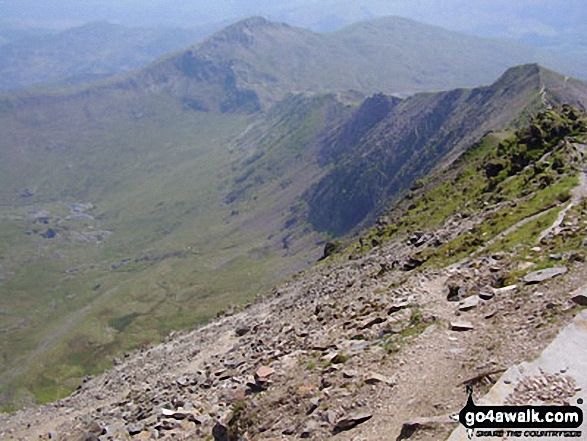
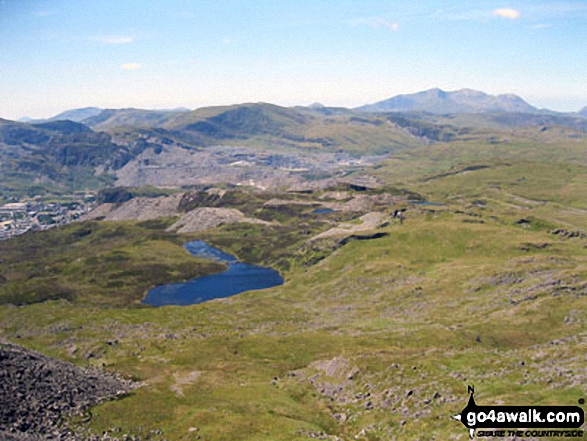
Cwm Llan and Yr Aran (right - in shadow) from Bwlch y Saethau on the upper slopes of Snowdon (Yr Wyddfa)
Garnedd Ugain (Crib y Ddysgl), Snowdon (Yr Wyddfa), Y Lliwedd & Yr Aran from the summit of Craig Cwm Silyn
The Snowdon Massif (Garnedd Ugain (Crib y Ddysgl), Snowdon (Yr Wyddfa), Y Lliwedd & Yr Aran) and Llyn y Dywarchen from Mynydd Drws-y-coed
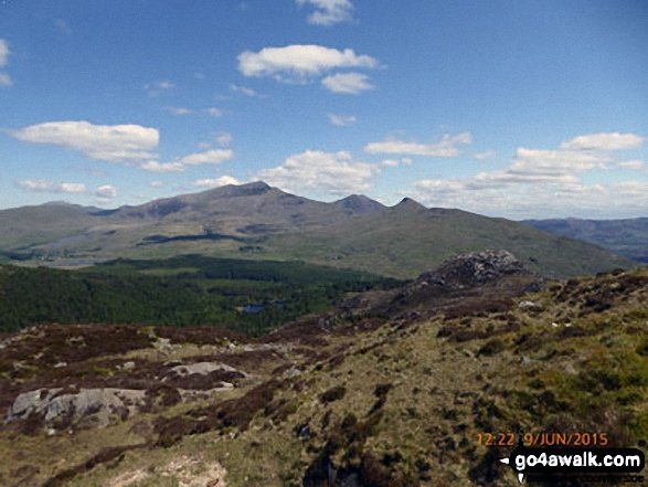
Llyn-y-Gader with Garnedd Ugain (Crib y Ddysgl), Snowdon (Yr Wyddfa), Y Lliwedd & Yr Aran (right) from Beddgelert Forest near Cwm Marchnad
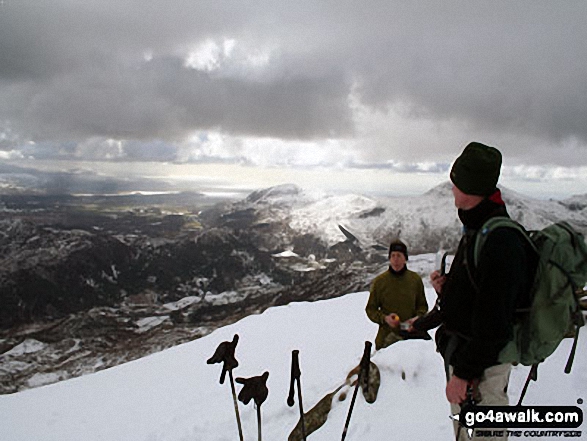
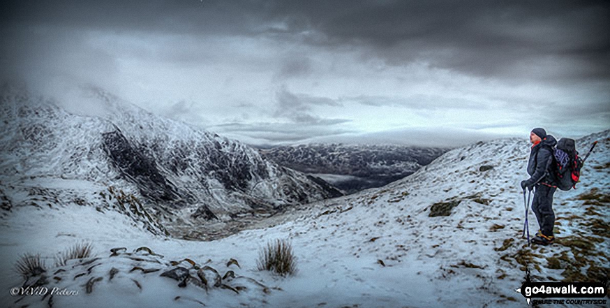
Friends on the summit of Yr Aran in the snow with Beddgelert below (left centre) and Moel Hebog on the horizon (right)
Llyn Nantlle Uchaf, Dyffryn Nantlle, Mynydd Mawr, Rhyd Ddu, Llyn y Dywarchen, The Snowdon Massif (Moel Eilio (Llanberis), Foel Gron, Moel Cynghorion, Garnedd Ugain (Crib y Ddysgl), Snowdon (Yr Wyddfa), Y Lliwedd and Yr Aran from Y Garn (Moel Hebog)
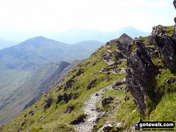
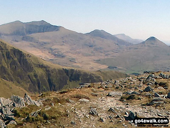
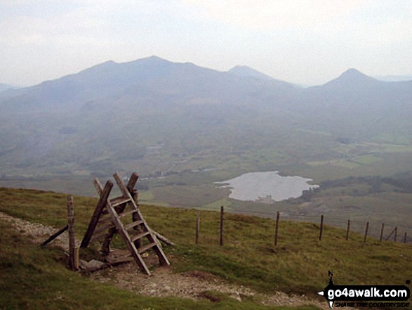
View back down the South Ridge to Yr Aran from the summit of Snowdon (Yr Wyddfa)
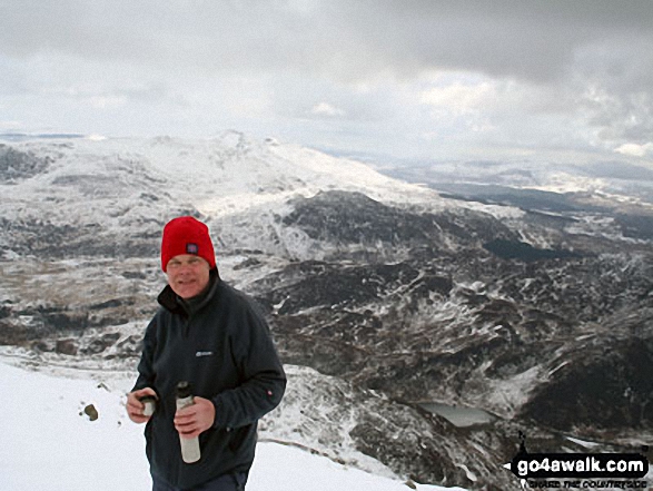
My dad on the summit of Yr Aran in the snow with Cnicht & Moelwyn Mawr on the horizon (left centre) and Lyn Dinas in the Nantgwynant valley below (right)
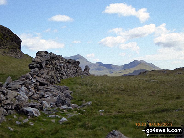
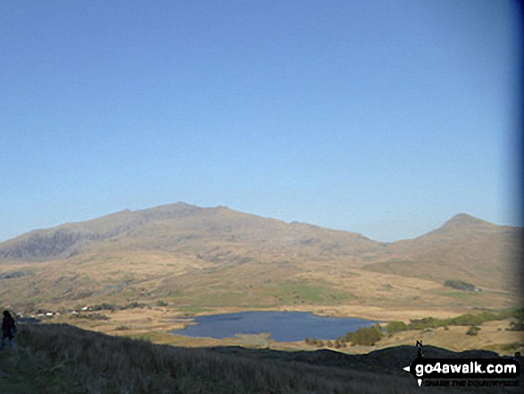
The Snowdon (Yr Wyddfa) (left) and Yr Aran (right) from Bwlch Meillionen
Mynydd Drws-y-coed & The Nantlle Ridge - with The Snowdon Massif (Garnedd Ugain (Crib y Ddysgl), Snowdon (Yr Wyddfa), Y Lliwedd and Yr Aran) beyond from Trum y Ddysgl

360 degree view from Moel Penamnen summit featuring (from left to right): The Moelwyns - Moelwyn Bach, Craigysgafn & Moelwyn Mawr, Allt-fawr, Moel Druman & Ysgafell Wen, Moel Farlwyd (foreground above/left of blue lake), Yr Aran (pointed peak above Moel Farlwyd), Mount Snowdon (Yr Wyddfa) & Y Lliwedd, The Glyderau - Glyder Fach, Glyder Fawr & Tryfan, Carnedd Moel Siabod, Y Ro Wen, Foel-fras (Moelwyns), Manod Mawr (above two light blue lakes) and The Arenigs - Arenig Fawr & Arenig Fach.
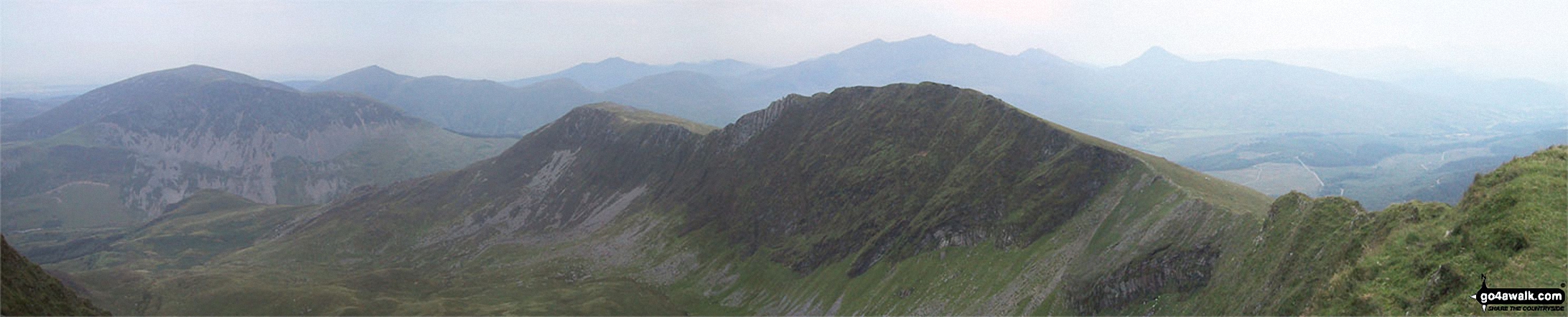
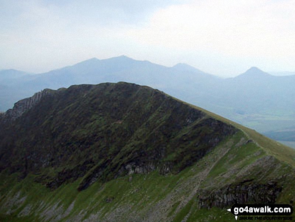
Yr Aran, Y Geuallt, Bwlch Cwm Llan, Allt Maederyn, Clogwyn Du and Bwlch Main from the Watkin Path on Bwlch Ciliau
Snowdon (Yr Wyddfa) (left), Yr Aran and Carnedd Moel Siabod (right) from Bwlch Cwm-trwsgl
Llyn Du-bach & Maen-offeren Quarry (foreground) with Allt-fawr, Moel Druman, Ysgafel Wen in the distance and Yr Aran, Mount Snowdon (Yr Wyddfa) and Y Lliwedd on the horizon from the summit of Manod Mawr (North Top)
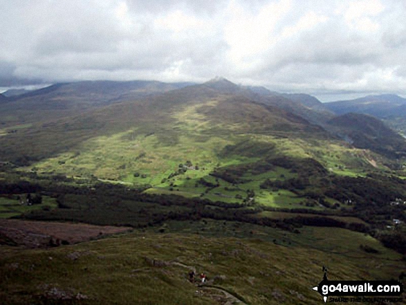
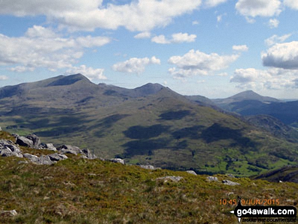
Snowdon (Yr Wyddfa) (left), Yr Aran and Carnedd Moel Siabod (right) from the summit of Moel Yr Ogof
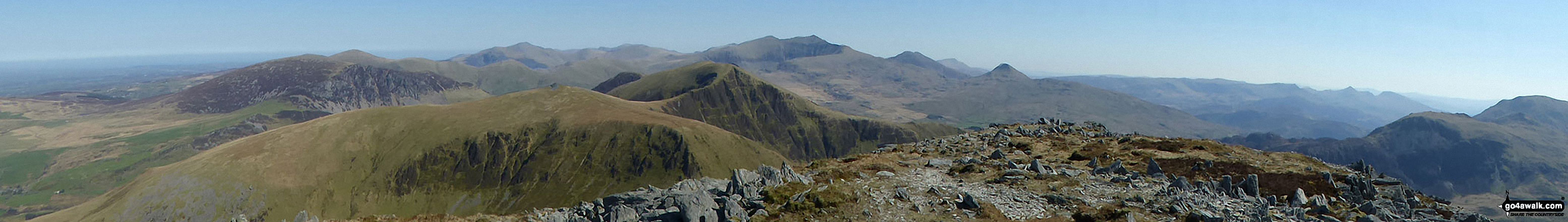
Mynydd Mawr (Llyn Celyn), Craig y Bera, Mynydd Tal-y-mignedd and Mynydd Drws-y-coed from the summit of Craig Cwm Silyn with Garnedd Ugain (Crib y Ddysgl), Snowdon (Yr Wyddfa), Y Lliwedd & Yr Aran on the horizon (centre) and Moel Lefn, Moel yr Ogof & Moel Hebog on the far left
. . . see just 20 walk photographs & pictures of views from, on or of Yr Aran
Send us your photographs and pictures on, of, or from Yr Aran
If you would like to add your walk photographs and pictures featuring views from, on or of Yr Aran to this page, please send them as email attachments (configured for any computer) along with your name to:
and we shall do our best to publish them.
(Guide Resolution = 300dpi. At least = 660pixels (wide) x 440 pixels (high).)

You can also submit photos via our Facebook Page.
NB. Please indicate where each photo was taken and whether you wish us to credit your photos with a Username or your First Name/Last Name.
Not familiar with this top?


