
![]()
Windgate Edge
523m (1716ft)
The Dark Peak Area, The Peak District, Derbyshire/Greater Manchester, England
Tap/mouse over a coloured circle (1-3 easy walks, 4-6 moderate walks, 7-9 hard walks) and click to select.
Not familiar with this top?
   |
|---|
Vital Statistics:
| Length: | 12.5mls (20km) |
|---|---|
| Ascent: | 2,143ft (653m) |
| Time: | 6.75hrs |
| Grade: |  (Hard) (Hard) |
Route Summary:
Hadfield - The Longdenden Trail - Tintwistle - Arnfield Gamekeepers Cottage - Arnfield Brook - Arnfield Farm - Tintwistle Low Moor - Ogden Brook - Arnfield Moor - Arnfield Flats - Ormes Moor - Wilderness - Windgate Edge - Blindstones Moor - Featherbed Moss (Chew Reservoir) - Laddow Moss - Black Chew Head (Laddow Rocks) - The Pennine Way - Oakenclough Brook - Rakes Rocks - Highstone Rocks - Torside Reservoir - Rhodeswood Reservoir - The Longdendale Trail - Hadfield
See Windgate Edge and the surrounding tops on our free-to-access 'Google Style' Peak Bagging Maps:
The Dark Peak Area of The Peak District National Park
Less data - quicker to download
See Windgate Edge and the surrounding tops on our downloadable Peak Bagging Map in PDF format:

NB: Whether you print off a copy or download it to your phone, this PDF Peak Baggers' Map might prove incredibly useful when your are up there on the tops and you cannot get a phone signal.
You can find Windgate Edge & all the walks that climb it on these unique free-to-access Interactive Walk Planning Maps:
1:25,000 scale OS Explorer Map (orange/yellow covers):
1:50,000 scale OS Landranger Map (pink/magenta covers):
 Fellow go4awalkers who have already walked, climbed, summited & bagged Windgate Edge
hannah1507 walked up Windgate Edge on May 6th, 2023 [from/via/route] Walk d213 Black Chew Head (Laddow Rocks) & The Longdenden Trail from Hadfield [with] Solo
Mark Davidson climbed Windgate Edge on May 11th, 2010 [from/via/route] Walk d213 Black Chew Head (Laddow Rocks) & The Longdenden Trail from Hadfield [with] Alone [weather] Nice & sunny
Christine Shepherd bagged Windgate Edge on May 16th, 2019 [from/via/route] Walked from Hadfield using walk d213 [with] On my own [weather] Lovely walking weather sunny with a pleasant breeze.
Patrick Rogozinski has walked, climbed & bagged Windgate Edge.
To add (or remove) your name and experiences on this page - Log On and edit your Personal Mountain Bagging Record
More Photographs & Pictures of views from, on or of Windgate Edge
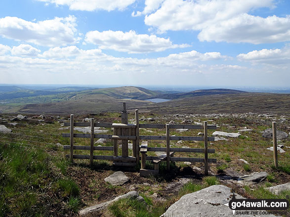
The view from Windgate Edge with Dove Stone Reservoir and Dick Hill in the distance
Send us your photographs and pictures on, of, or from Windgate Edge
If you would like to add your walk photographs and pictures featuring views from, on or of Windgate Edge to this page, please send them as email attachments (configured for any computer) along with your name to:
and we shall do our best to publish them.
(Guide Resolution = 300dpi. At least = 660pixels (wide) x 440 pixels (high).)

You can also submit photos via our Facebook Page.
NB. Please indicate where each photo was taken and whether you wish us to credit your photos with a Username or your First Name/Last Name.
Not familiar with this top?


