
![]()
Hitter Hill
362m (1188ft)
The White Peak Area, The Peak District, Derbyshire, England
Tap/mouse over a coloured circle (1-3 easy walks, 4-6 moderate walks, 7-9 hard walks) and click to select.
Not familiar with this top?
   |
|---|
Vital Statistics:
| Length: | 4.5ml (7km) |
|---|---|
| Ascent: | 834ft (254m) |
| Time: | 2½ hrs |
| Grade: |  (Easy) (Easy) |
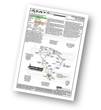
Route Summary:
Longnor - River Dove - Beggar's Bridge - High Wheeldon - Abbotside Farm - Earl Sterndale - Hitter Hill - Parkhouse Hill - High Acres - Yewtree Grange - Underhill Farm - Longnor
|
|---|
Vital Statistics:
| Length: | 7.25ml (11.5km) |
|---|---|
| Ascent: | 1,657ft (505m) |
| Time: | 4.25hrs |
| Grade: |  (Moderate) (Moderate) |
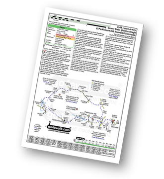
Route Summary:
Earl Sterndale - Glutton Grange - Hatch-a-way - Dowel Dale - Owl Hole - Greensides Farm - Stoop Farm - Booth Farm - Leycote Farm - Packhorse Bridge - Moorside Farm - Hollinsclough - Swallow Brook - Parkhouse Hill - Hitter Hill - Earl Sterndale
|
|---|
Vital Statistics:
| Length: | 10.5ml (16.5km) |
|---|---|
| Ascent: | 1,287ft (392m) |
| Time: | 5 hrs |
| Grade: | (Moderate) |
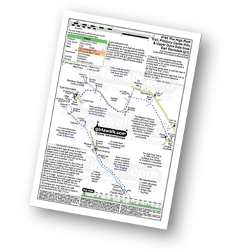
Route Summary:
Earl Sterndale - Hindlow Quarry - Dowlow Works - The Midshires Way - The High Peak Trail - Pomeroy - Hurdlow - Parsley Hay - Darley Farm - Vincent House - Pilsbury - Pilsbury Castle Hills - Upper Dove Dale - Bridge End Farm - Crowdecote - Meadow Farm - Underhill Farm - Hitter Hill - Earl Sterndale
|
|---|
Vital Statistics:
| Length: | 14.5ml (23.5km) |
|---|---|
| Ascent: | 3,049ft (929m) |
| Time: | 8½ hrs |
| Grade: | (Moderate) |
Route Summary:
Longnor - The Manifold Trail - Gauledge Farm - Fawside Farm - The River Manifold - Hardings Booth - Ball Bank Farm - The River Manifold - Heathylee House - Hollinsclough Moor - Wilshaw Bottom - Wilshaw Farm - Moorside Farm - Hollinsclough - Hollins Farm - Swallow Brook - Parkhouse Hill - Hitter Hill - Earl Sterndale - Abbots Grove - Wheeldon Trees - High Wheeldon - Crowdecote - Bridge End Farm - Pilsbury Castle Hills - Pilsbury - Sheen Lane Farm - Ridge End Farm - The Manifold Trail - Lower Boothlow Farm - Folds End Farm - Longnor
See Hitter Hill and the surrounding tops on our free-to-access 'Google Style' Peak Bagging Maps:
The White Peak Area of The Peak District National Park
Less data - quicker to download
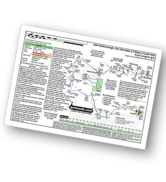
See Hitter Hill and the surrounding tops on our downloadable Peak Bagging Map in PDF format:

NB: Whether you print off a copy or download it to your phone, this PDF Peak Baggers' Map might prove incredibly useful when your are up there on the tops and you cannot get a phone signal.
You can find Hitter Hill & all the walks that climb it on these unique free-to-access Interactive Walk Planning Maps:
1:25,000 scale OS Explorer Map (orange/yellow covers):
1:50,000 scale OS Landranger Map (pink/magenta covers):
 Fellow go4awalkers who have already walked, climbed, summited & bagged Hitter Hill
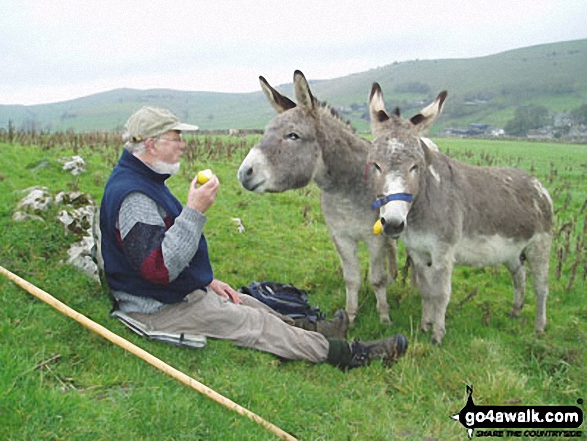
Andrew Joss walked up Hitter Hill on May 26th, 2014 [from/via/route] Longnor [with] Barbara [weather] Sunny - Nice views
Louise Sandwith, Alya Hazell and Mark Davidson have all walked, climbed & bagged Hitter Hill.
To add (or remove) your name and experiences on this page - Log On and edit your Personal Mountain Bagging Record
Send us your photographs and pictures on, of, or from Hitter Hill
If you would like to add your walk photographs and pictures featuring views from, on or of Hitter Hill to this page, please send them as email attachments (configured for any computer) along with your name to:
and we shall do our best to publish them.
(Guide Resolution = 300dpi. At least = 660pixels (wide) x 440 pixels (high).)

You can also submit photos via our Facebook Page.
NB. Please indicate where each photo was taken and whether you wish us to credit your photos with a Username or your First Name/Last Name.
Not familiar with this top?


