
![]()
Beinn Fhada (Stob Coire Sgreamhach)
952m (3124ft)
The Glen Coe Mountains, Loch Leven to Connel Bridge, Strath of Orchy and Glen Lochy, Highland, Scotland
Tap/mouse over a coloured circle (1-3 easy walks, 4-6 moderate walks, 7-9 hard walks) and click to select.
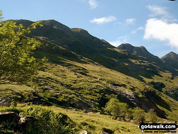
Beinn Fhada (Stob Coire Sgreamhach) from Coire Gabhail (The 'Lost Valley' of Glen Coe)
Not familiar with this top?
   |
|---|
Vital Statistics:
| Length: | 9.5ml (15km) |
|---|---|
| Ascent: | 6,173ft (1,881m) |
| Time: | 10 hrs |
| Grade: |  (Hard) (Hard) |
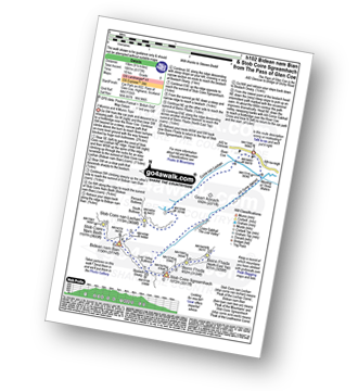
Route Summary:
The Pass of Glencoe - The River Coe - Coire Nan Lochan - Stob Coire Nan Lochan (Bidean Nam Bian) - Bidean Nam Bian - Stob Coire Nam Beith (Bidean Nam Bian) - Bidean Nam Bian - Lost Valley Buttress - Bealach Dearg - Stob Coire Sgreamhach - Beinn Fhada (Stob Coire Sgreamhach) - Beinn Fhada (Stob Coire Sgreamhach) (North East Top) - Beinn Fhada (Stob Coire Sgreamhach) - Stob Coire Sgreamhach - Bealach Dearg - Coire Gabhail (The 'Lost Valley') - Allt Corrie Gabhail - The Pass of Glencoe
|
|---|
Vital Statistics:
| Length: | 9.75ml (16.5km) |
|---|---|
| Ascent: | 5,405ft (1,647m) |
| Time: | 9 hrs |
| Grade: | (Hard) |
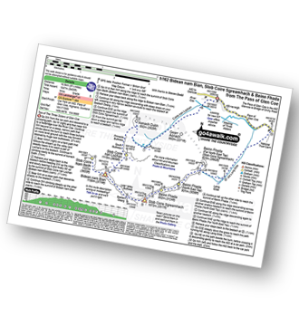
Route Summary:
The Pass of Glencoe - River Coe - Coire Nan Lochan - Aonach Dubh - Stob Coire Nan Lochan (Bidean Nam Bian) - Bidean Nam Bian - Stob Coire Nam Beith (Bidean Nam Bian) - Bidean Nam Bian - Lost Valley Buttress - Bealach Dearg - Stob Coire Sgreamhach - Beinn Fhada (Stob Coire Sgreamhach) - Beinn Fhada (Stob Coire Sgreamhach) (North East Top) - Beinn Fhada (Stob Coire Sgreamhach) (Far North East Top) - Lairig Eilde - Allt Lairig Eilde - The Pass of Glencoe
See Beinn Fhada (Stob Coire Sgreamhach) and the surrounding tops on our free-to-access 'Google Style' Peak Bagging Maps:
The Glen Coe Mountains area of Scottish Region 3: Loch Leven to Connel Bridge, Strath of Orchy and Glen Lochy
Less data - quicker to download
Scottish Region 3: Loch Leven to Connel Bridge, Strath of Orchy and Glen Lochy
Less data - quicker to download
See Beinn Fhada (Stob Coire Sgreamhach) and the surrounding tops on our downloadable Peak Bagging Map in PDF format:

NB: Whether you print off a copy or download it to your phone, this PDF Peak Baggers' Map might prove incredibly useful when your are up there on the tops and you cannot get a phone signal.
You can find Beinn Fhada (Stob Coire Sgreamhach) & all the walks that climb it on these unique free-to-access Interactive Walk Planning Maps:
1:25,000 scale OS Explorer Map (orange/yellow covers):
1:50,000 scale OS Landranger Map (pink/magenta covers):
 Fellow go4awalkers who have already walked, climbed, summited & bagged Beinn Fhada (Stob Coire Sgreamhach)
Mark Davidson walked up Beinn Fhada (Stob Coire Sgreamhach) on June 30th, 2015 [with] Alone [weather] Cloud base at 945m on the way up - but had risen above the summits by the time I reached Beinn Fhada (Stob Coire Sgreamhach)
Mr M A Blanchard has walked, climbed & bagged Beinn Fhada (Stob Coire Sgreamhach).
To add (or remove) your name and experiences on this page - Log On and edit your Personal Mountain Bagging Record
More Photographs & Pictures of views from, on or of Beinn Fhada (Stob Coire Sgreamhach)
Stob Coire Sgreamhach (left) & Beinn Fhada (Stob Coire Sgreamhach) (in sunlight in the foreground) with Bidean nam Bian & Stob Coire nam Beith (in shadow behind) from the summit of Buachaille Etive Beag (Stob Dubh)
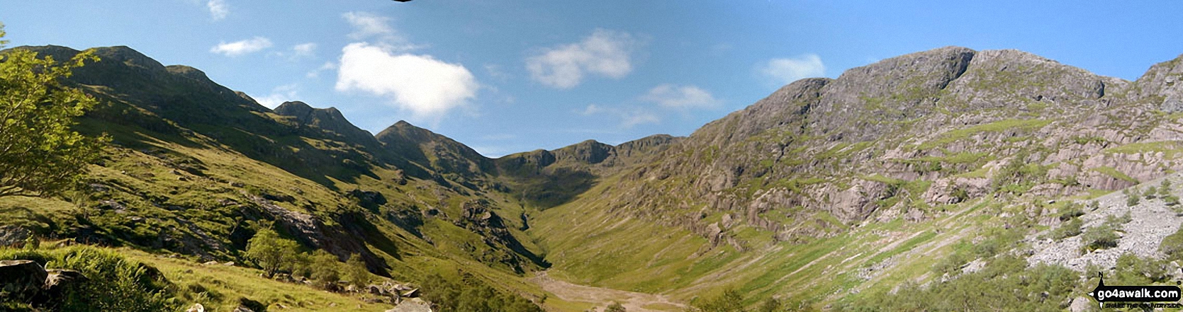
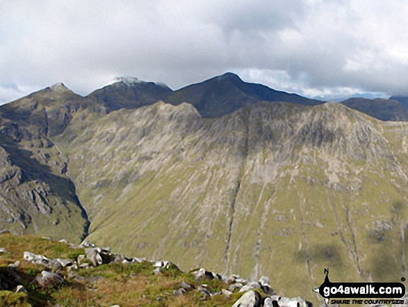
*Beinn Fhada (Stob Coire Sgreamhach) (left), Stob Coire Sgreamhach (centre left), Bidean Nam Bian (centre right) and Gearr Aonach (right) from Coire Gabhail (The 'Lost Valley' of Glen Coe)
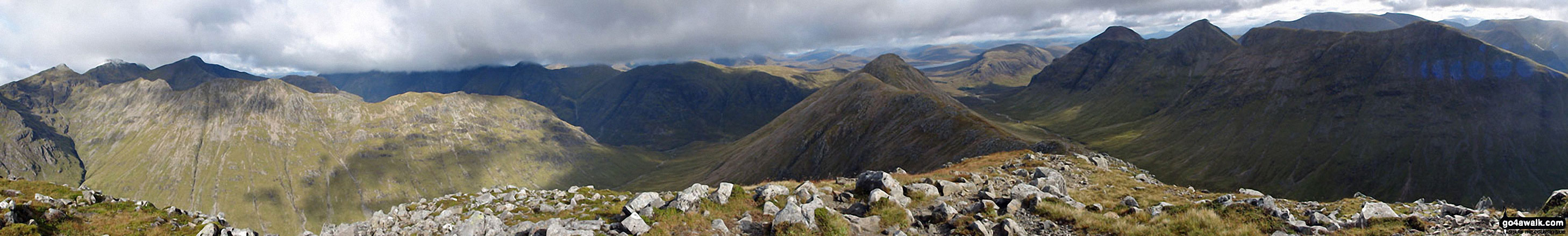
Stob Coire Sgreamhach (left) & Beinn Fhada (Stob Coire Sgreamhach) (foreground - left) with Bidean nam Bian & Stob Coire nam Beith (in shadow behind), Stob Coire Raineach (Buachaille Etive Beag) (centre), Buachaille Etive Mor (Stob Dearg), Stob na Doire (Buachaille Etive Mor), Stob Coire Altruim (Buachaille Etive Mor) & Stob na Broige (Buachaille Etive Mor) (right) with Clach Leathad (Creise), Creise & Stob A' Ghlais Choire (Creise) behind from the summit of Buachaille Etive Beag (Stob Dubh)
Send us your photographs and pictures on, of, or from Beinn Fhada (Stob Coire Sgreamhach)
If you would like to add your walk photographs and pictures featuring views from, on or of Beinn Fhada (Stob Coire Sgreamhach) to this page, please send them as email attachments (configured for any computer) along with your name to:
and we shall do our best to publish them.
(Guide Resolution = 300dpi. At least = 660pixels (wide) x 440 pixels (high).)

You can also submit photos via our Facebook Page.
NB. Please indicate where each photo was taken and whether you wish us to credit your photos with a Username or your First Name/Last Name.
Not familiar with this top?


