Munro, Murdo & Marilyn Icon

Sgurr na h-Ulaidh
994m (3262ft)


The Glen Coe Mountains, Loch Leven to Connel Bridge, Strath of Orchy and Glen Lochy, Highland, Scotland


Tap/mouse over a coloured circle (1-3 easy walks, 4-6 moderate walks, 7-9 hard walks) and click to select.


Record Sgurr na h-Ulaidh as Bagged, Climbed & Conquered

Munro Icon

Munro
No. 149

Murdo Icon

Murdo
No. 212

Scottish Marilyn Icon

Scottish Marilyn
117th highest in Scotland,
120th highest in Great Britain

Walk Sgurr na h-Ulaidh walking UK Mountains in Loch Leven to Connel Bridge, Strath of Orchy and Glen Lochy  Highland, Scotland

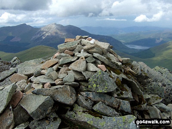
Sgor na h-Ulaidh summit cairn with Sgorr Dhonuill (Beinn a' Bheithir), Sgorr Dhearg (Beinn a' Bheithir) and Loch Leven un the background

Photo: Ian Taylor


Not familiar with this top?

How is Sgurr na h-Ulaidh classified?

See the location of Sgurr na h-Ulaidh on an interactive Google Map

See the location of Sgurr na h-Ulaidh on an interactive Google Bagging Map

See the location of Sgurr na h-Ulaidh on our unique free-to-access Interactive Walk Planning Maps (worth a look if you've never seen these)

Read walk reports from hikers who have already bagged Sgurr na h-Ulaidh


We will be adding easy-to-follow route maps up Sgurr na h-Ulaidh very soon.

See Sgurr na h-Ulaidh and the surrounding tops on our free-to-access 'Google Style' Peak Bagging Maps:

Find Google Maps Peak Bagging Map Icon

The Glen Coe Mountains area of Scottish Region 3: Loch Leven to Connel Bridge, Strath of Orchy and Glen Lochy
Less data - quicker to download

Find Google Maps Peak Bagging Map Icon

Scottish Region 3: Loch Leven to Connel Bridge, Strath of Orchy and Glen Lochy
Less data - quicker to download


See Sgurr na h-Ulaidh and the surrounding tops on our downloadable Peak Bagging Map in PDF format:

Find PDF Peak Bagging Map Icon

The Glen Coe Mountains of Scottish Region 3: Loch Leven to Connel Bridge, Strath of Orchy and Glen Lochy

NB: Whether you print off a copy or download it to your phone, this PDF Peak Baggers' Map might prove incredibly useful when your are up there on the tops and you cannot get a phone signal.


You can find Sgurr na h-Ulaidh & all the walks that climb it on these unique free-to-access Interactive Walk Planning Maps:


1:25,000 scale OS Explorer Map (orange/yellow covers):

OS Explorer 384 Glen Coe


1:50,000 scale OS Landranger Map (pink/magenta covers):

OS Landranger 41 Ben Nevis, Fort William & Glen Coe


Top


Other walkers who hiked, climbed, bagged and summited Sgurr na h-Ulaidh Fellow go4awalkers who have already walked, climbed, summited & bagged Sgurr na h-Ulaidh

Daniel Moran walked up Sgurr na h-Ulaidh on November 25th, 2024 [from/via/route] Corran bunk house [weather] stunning - Great views

Mark Davidson climbed Sgor na h-Ulaidh on June 14th, 2009 [with] MK - well I saw him at the start & at the top but not much in between . . . <br>Bagged again on June 29th, 2015 when climbing Stob an Fhuarain [weather] Pretty good - bit misty at the top but breaks in the cloud allowed good views

Mr M A Blanchard, Simon Duerden, Paul Booth and Trevor Williams have all walked, climbed & bagged Sgor na h-Ulaidh.

To add (or remove) your name and experiences on this page - Log On and edit your Personal Mountain Bagging Record

Top


Send us your photographs and pictures on, of, or from Sgurr na h-Ulaidh

If you would like to add your walk photographs and pictures featuring views from, on or of Sgurr na h-Ulaidh to this page, please send them as email attachments (configured for any computer) along with your name to:


and we shall do our best to publish them.

(Guide Resolution = 300dpi. At least = 660pixels (wide) x 440 pixels (high).)

Send us your photographs and pictures on, of, or from Sgurr na h-Ulaidh via Facebook

You can also submit photos via our Facebook Page.

NB. Please indicate where each photo was taken and whether you wish us to credit your photos with a Username or your First Name/Last Name.

Top


Not familiar with this top?

How is Sgurr na h-Ulaidh classified?

See the location of Sgurr na h-Ulaidh on an interactive Google Map

See the location of Sgurr na h-Ulaidh on an interactive Google Bagging Map

See the location of Sgurr na h-Ulaidh on our unique free-to-access Interactive Walk Planning Maps (worth a look if you've never seen these)

Read walk reports from hikers who have already bagged Sgurr na h-Ulaidh


Follow go4awalk.com on Twitter Follow go4awalk.com on Facebook


Home


Find new Friends to go walking with

Walk all 214 Wainwrights in just 59 Walks. Download GPS Waypoints - Great Walks you must not miss!

Walk The Yorkshire Three Peaks Challenge Walk - All the Latest Route Information, GPS Waypoints and Split Times to keep you on Schedule

Walk The British Three Peaks Challenge Walk - All the Latest Route Information and GPS Waypoints

See our pick of The Best Walks in The Lake District - Great Walks you must not miss!

Walk our pick of the Best Lake District Ridge Walks - Great Walks you must not miss!

Walk our pick of the Best Lake District Walks to do in the rain - Great Walks you must not miss!

Walk our pick of The Best Walks in Snowdonia - Great Walks you must not miss!

Walk our pick of The Best Ridge Walks in Wales - Walks you must not miss!

Walk our pick of The Best Walks in The Brecon Beacons - Great Walks you must not miss!

Walk our pick of The Best Walks in The Yorkshire Dales - Walks you must not miss!

Walk our pick of The Best Walks in The Peak District - Walks you must not miss!

Walk our pick of The Best Walks in The Forest of Bowland - Walks you must not miss!

Walk our pick of The Best Walks in Shropshire - Walks you must not miss!

Walk our pick of The Best Walks in Cheshire - Walks you must not miss!

Walk our pick of The Best Walks in Lancashire - Walks you must not miss!

Not sure where to walk next? Try Peak Bagging - Great Walks you must not miss!

Not sure where to walk next? Walk part of a National Trail - Great Walks you must not miss!

Walks with Downloadable and Uploadable GPS Waypoint Data

Walking Kit and Gear Tested by Walkers

Full Site Search