
![]()
Carncliff Top (Earl Seat)
449m (1473ft)
The Southern Dales Area, The Yorkshire Dales, North Yorkshire, England
Tap/mouse over a coloured circle (1-3 easy walks, 4-6 moderate walks, 7-9 hard walks) and click to select.
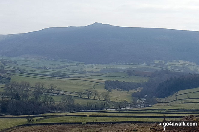
Carncliff Top (Earl Seat) from the B6160 (Intake Plantation area) looking SE with the River Wharfe in the valley
Not familiar with this top?
   |
|---|
Vital Statistics:
| Length: | 9ml (14.5km) |
|---|---|
| Ascent: | 1,805ft (550m) |
| Time: | 5.25hrs |
| Grade: |  (Moderate) (Moderate) |
Route Summary:
Wharfedale - Barden Bridge - The River Wharfe - Wharfedale - The Dales Way - The Strid. Strid Wood - Waterfall Cottage - Posforth Gill - Valley of Desolation - Laund Pasture Plantation - Smithyman Nook - Carncliff Top (Earl Seat) - Nanny Crag - Truckle Crags - Simon's Seat (Wharfedale) - Dalehead Farm - Eastwood Head - Howgill Lodge - The Dales Way - The River Wharfe - Barden Bridge - Wharfedale
See Carncliff Top (Earl Seat) and the surrounding tops on our free-to-access 'Google Style' Peak Bagging Maps:
The Southern Dales Area of The Yorkshire Dales National Park
Less data - quicker to download
The Whole of The Yorkshire Dales National Park
More data - might take a little longer to download
See Carncliff Top (Earl Seat) and the surrounding tops on our downloadable Peak Bagging Map in PDF format:

NB: Whether you print off a copy or download it to your phone, this PDF Peak Baggers' Map might prove incredibly useful when your are up there on the tops and you cannot get a phone signal.
Free-to-access Interactive Walk Planning Maps:
1:25,000 scale OS Explorer Map (orange/yellow covers):
1:50,000 scale OS Landranger Map (pink/magenta covers):
An Interactive Walk Planning Map for OS Landranger 104 Leeds & Bradford, Harrogate & Ilkley is not currently available
 Fellow go4awalkers who have already walked, climbed, summited & bagged Carncliff Top (Earl Seat)
Margaret Richards walked up Carncliff Top (Earl Seat) on February 17th, 2015 [from/via/route] on route to Simon's Seat from Barden bridge [with] Don
Matthew Crank climbed Carncliff Top (Earl Seat) on September 2nd, 2012 [from/via/route] Barden bridge [with] Becki Empson, fiancee [weather] Pleasant , clear
Christine Shepherd bagged Carncliff Top (Earl Seat) on July 9th, 2012 [from/via/route] Walked from Barden Bridge [with] On my own [weather] Damp & misty - Take care in the ankle turning heather on this summit.
To add (or remove) your name and experiences on this page - Log On and edit your Personal Mountain Bagging Record
Send us your photographs and pictures on, of, or from Carncliff Top (Earl Seat)
If you would like to add your walk photographs and pictures featuring views from, on or of Carncliff Top (Earl Seat) to this page, please send them as email attachments (configured for any computer) along with your name to:
and we shall do our best to publish them.
(Guide Resolution = 300dpi. At least = 660pixels (wide) x 440 pixels (high).)

You can also submit photos via our Facebook Page.
NB. Please indicate where each photo was taken and whether you wish us to credit your photos with a Username or your First Name/Last Name.
Not familiar with this top?


