All The Mountains, Peaks, Tops and Hills in Scottish Region 7: Scottish Region 7: The East Mounth - Glen Shee and Mount Keen to Montrose as a detailed list

Scottish Region 7: The East Mounth - Glen Shee and Mount Keen to Montrose region is the area enclosed by an imaginary line connecting:


If you include all the Munros, the Corbetts, the Grahams, the Donalds, the Murdos, the Marilyns, the Bridgets (Hills) and all the Mountains, Tops, Peaks and Hills with a Trig Point on them there are 56 tops to climb, bag & conquer and the highest point is Lochnagar (Cac Carn Beag) at 1,155m (3,791ft).

munro
14/0
Munros

corbett
5/0
Corbetts

graham
6/0
Grahams

donald
0/0
Donalds

murdo
20/0
Murdos

marilyn
26/0
Scottish
Marilyns

Bridget
13/0
Scottish
Bridgets

Trig Point
26/0
Trig
Points


To see all Mountains, Peaks, Tops and Hills displayed in different ways - see the options in the left-hand column and towards the bottom of this page.


LOG ON and RELOAD this page to show which Mountains, Peaks, Tops and Hills you have already climbed, bagged & conquered [. . . more]


Page 1 of 2    Go to page: 1 2


See this list in: Alphabetical Order | Height Order
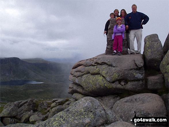
To reverse the order select the link again.


Mountain, Peak, Top or Hill:

Bagged


1. Lochnagar (Cac Carn Beag)

1,155m (3,791ft)

  • Munro (No. 20)
  • Murdo (28th)
  • Marilyn (16th in Scotland, 16th in GB)
  • OS Trig Point

  • We hope to have walks that climb & bag Lochnagar (Cac Carn Beag) very soon

    Google Maps Icon
    See the location of Lochnagar (Cac Carn Beag) and walks up it on a google Map

    Lochnagar (Cac Carn Beag) is on interactive maps:

  • OS Explorer (Orange Covers): OL53
  • OS Landranger (Pink Covers): 44

  • A go4awalk.com Peak Bagging Map and Hill Tick List featuring Lochnagar (Cac Carn Beag) will be available soon.


    2. Carn a' Choire Boidheach

    1,110m (3,643ft)

  • Munro (No. 43)
  • Murdo (57th)

  • We hope to have walks that climb & bag Carn a' Choire Boidheach very soon

    Google Maps Icon
    See the location of Carn a' Choire Boidheach and walks up it on a google Map

    Carn a' Choire Boidheach is on interactive maps:

  • OS Explorer (Orange Covers): OL53
  • OS Landranger (Pink Covers): 44

  • A go4awalk.com Peak Bagging Map and Hill Tick List featuring Carn a' Choire Boidheach will be available soon.


    3. Cuidhe Crom (Lochnagar)

    1,083m (3,554ft)

  • Murdo (81st)

  • We hope to have walks that climb & bag Cuidhe Crom (Lochnagar) very soon

    Google Maps Icon
    See the location of Cuidhe Crom (Lochnagar) and walks up it on a google Map

    Cuidhe Crom (Lochnagar) is on interactive maps:

  • OS Explorer (Orange Covers): OL53
  • OS Landranger (Pink Covers): 44

  • A go4awalk.com Peak Bagging Map and Hill Tick List featuring Cuidhe Crom (Lochnagar) will be available soon.


    4. Glas Maol

    1,068m (3,505ft)

  • Munro (No. 69)
  • Murdo (94th)
  • Marilyn (54th in Scotland, 55th in GB)
  • OS Trig Point

  • We hope to have walks that climb & bag Glas Maol very soon

    Google Maps Icon
    See the location of Glas Maol and walks up it on a google Map

    Glas Maol is on interactive maps:

  • OS Explorer (Orange Covers): OL52
  • OS Landranger (Pink Covers): 43

  • A go4awalk.com Peak Bagging Map and Hill Tick List featuring Glas Maol will be available soon.


    5. Cairn of Claise

    1,064m (3,492ft)

  • Munro (No. 71)
  • Murdo (97th)

  • We hope to have walks that climb & bag Cairn of Claise very soon

    Google Maps Icon
    See the location of Cairn of Claise and walks up it on a google Map

    Cairn of Claise is on interactive maps:

  • OS Explorer (Orange Covers): OL52 and OL53
  • OS Landranger (Pink Covers): 43

  • A go4awalk.com Peak Bagging Map and Hill Tick List featuring Cairn of Claise will be available soon.


    6. Carn an t-Sagairt Mor

    1,047m (3,436ft)

  • Munro (No. 84)
  • Murdo (114th)

  • We hope to have walks that climb & bag Carn an t-Sagairt Mor very soon

    Google Maps Icon
    See the location of Carn an t-Sagairt Mor and walks up it on a google Map

    Carn an t-Sagairt Mor is on interactive maps:

  • OS Explorer (Orange Covers): OL53
  • OS Landranger (Pink Covers): 44

  • A go4awalk.com Peak Bagging Map and Hill Tick List featuring Carn an t-Sagairt Mor will be available soon.


    7. Carn an t-Sagairt Beag

    1,044m (3,426ft)

  • Murdo (123rd)

  • We hope to have walks that climb & bag Carn an t-Sagairt Beag very soon

    Google Maps Icon
    See the location of Carn an t-Sagairt Beag and walks up it on a google Map

    Carn an t-Sagairt Beag is on interactive maps:

  • OS Explorer (Orange Covers): OL53
  • OS Landranger (Pink Covers): 44

  • A go4awalk.com Peak Bagging Map and Hill Tick List featuring Carn an t-Sagairt Beag will be available soon.


    8. Carn an Tuirc

    1,019m (3,344ft)

  • Munro (No. 113)
  • Murdo (157th)

  • We hope to have walks that climb & bag Carn an Tuirc very soon

    Google Maps Icon
    See the location of Carn an Tuirc and walks up it on a google Map

    Carn an Tuirc is on interactive maps:

  • OS Explorer (Orange Covers): OL52 and OL53
  • OS Landranger (Pink Covers): 43

  • A go4awalk.com Peak Bagging Map and Hill Tick List featuring Carn an Tuirc will be available soon.


    9. Cairn Bannoch

    1,012m (3,321ft)

  • Munro (No. 117)
  • Murdo (164th)

  • We hope to have walks that climb & bag Cairn Bannoch very soon

    Google Maps Icon
    See the location of Cairn Bannoch and walks up it on a google Map

    Cairn Bannoch is on interactive maps:

  • OS Explorer (Orange Covers): OL53
  • OS Landranger (Pink Covers): 44

  • A go4awalk.com Peak Bagging Map and Hill Tick List featuring Cairn Bannoch will be available soon.


    10. Broad Cairn

    998m (3,275ft)

  • Munro (No. 142)
  • Murdo (200th)

  • We hope to have walks that climb & bag Broad Cairn very soon

    Google Maps Icon
    See the location of Broad Cairn and walks up it on a google Map

    Broad Cairn is on interactive maps:

  • OS Explorer (Orange Covers): OL53
  • OS Landranger (Pink Covers): 44

  • A go4awalk.com Peak Bagging Map and Hill Tick List featuring Broad Cairn will be available soon.


    11. Creag Leacach

    987m (3,239ft)

  • Munro (No. 159)
  • Murdo (225th)

  • We hope to have walks that climb & bag Creag Leacach very soon

    Google Maps Icon
    See the location of Creag Leacach and walks up it on a google Map

    Creag Leacach is on interactive maps:

  • OS Explorer (Orange Covers): OL52
  • OS Landranger (Pink Covers): 43

  • A go4awalk.com Peak Bagging Map and Hill Tick List featuring Creag Leacach will be available soon.


    12. Creag an Dubh-loch (Broad Cairn)

    983m (3,226ft)

  • Murdo (234th)

  • We hope to have walks that climb & bag Creag an Dubh-loch (Broad Cairn) very soon

    Google Maps Icon
    See the location of Creag an Dubh-loch (Broad Cairn) and walks up it on a google Map

    Creag an Dubh-loch (Broad Cairn) is on interactive maps:

  • OS Explorer (Orange Covers): OL53
  • OS Landranger (Pink Covers): 44

  • A go4awalk.com Peak Bagging Map and Hill Tick List featuring Creag an Dubh-loch (Broad Cairn) will be available soon.


    13. Meikle Pap (Lochnagar)

    980m (3,216ft)

  • Murdo (245th)

  • We hope to have walks that climb & bag Meikle Pap (Lochnagar) very soon

    Google Maps Icon
    See the location of Meikle Pap (Lochnagar) and walks up it on a google Map

    Meikle Pap (Lochnagar) is on interactive maps:

  • OS Explorer (Orange Covers): OL53
  • OS Landranger (Pink Covers): 44

  • A go4awalk.com Peak Bagging Map and Hill Tick List featuring Meikle Pap (Lochnagar) will be available soon.


    14. Meall Coire na Saobhaidhe (Lochnagar)

    974m (3,197ft)

  • Murdo (263rd)

  • We hope to have walks that climb & bag Meall Coire na Saobhaidhe (Lochnagar) very soon

    Google Maps Icon
    See the location of Meall Coire na Saobhaidhe (Lochnagar) and walks up it on a google Map

    Meall Coire na Saobhaidhe (Lochnagar) is on interactive maps:

  • OS Explorer (Orange Covers): OL53
  • OS Landranger (Pink Covers): 44

  • A go4awalk.com Peak Bagging Map and Hill Tick List featuring Meall Coire na Saobhaidhe (Lochnagar) will be available soon.


    15. Tolmount

    958m (3,144ft)

  • Munro (No. 202)
  • Murdo (301st)

  • We hope to have walks that climb & bag Tolmount very soon

    Google Maps Icon
    See the location of Tolmount and walks up it on a google Map

    Tolmount is on interactive maps:

  • OS Explorer (Orange Covers): OL53
  • OS Landranger (Pink Covers): 44

  • A go4awalk.com Peak Bagging Map and Hill Tick List featuring Tolmount will be available soon.


    16. Tom Buidhe

    957m (3,141ft)

  • Munro (No. 204)
  • Murdo (305th)

  • We hope to have walks that climb & bag Tom Buidhe very soon

    Google Maps Icon
    See the location of Tom Buidhe and walks up it on a google Map

    Tom Buidhe is on interactive maps:

  • OS Explorer (Orange Covers): OL53
  • OS Landranger (Pink Covers): 44

  • A go4awalk.com Peak Bagging Map and Hill Tick List featuring Tom Buidhe will be available soon.


    17. Driesh

    947m (3,108ft)

  • Munro (No. 219)
  • Murdo (329th)
  • OS Trig Point

  • We hope to have walks that climb & bag Driesh very soon

    Google Maps Icon
    See the location of Driesh and walks up it on a google Map

    Driesh is on interactive maps:

  • OS Explorer (Orange Covers): OL53
  • OS Landranger (Pink Covers): 44

  • A go4awalk.com Peak Bagging Map and Hill Tick List featuring Driesh will be available soon.


    18. Mount Keen

    939m (3,082ft)

  • Munro (No. 234)
  • Murdo (355th)
  • Marilyn (174th in Scotland, 180th in GB)
  • OS Trig Point

  • We hope to have walks that climb & bag Mount Keen very soon

    Google Maps Icon
    See the location of Mount Keen and walks up it on a google Map

    Mount Keen is on interactive maps:

  • OS Explorer (Orange Covers): OL54
  • OS Landranger (Pink Covers): 44

  • A go4awalk.com Peak Bagging Map and Hill Tick List featuring Mount Keen will be available soon.


    19. Mayar

    928m (3,046ft)

  • Munro (No. 255)
  • Murdo (389th)

  • We hope to have walks that climb & bag Mayar very soon

    Google Maps Icon
    See the location of Mayar and walks up it on a google Map

    Mayar is on interactive maps:

  • OS Explorer (Orange Covers): OL53
  • OS Landranger (Pink Covers): 44

  • A go4awalk.com Peak Bagging Map and Hill Tick List featuring Mayar will be available soon.


    20. Crow Craigies (Tolmount)

    920m (3,019ft)

  • Murdo (419th)

  • We hope to have walks that climb & bag Crow Craigies (Tolmount) very soon

    Google Maps Icon
    See the location of Crow Craigies (Tolmount) and walks up it on a google Map

    Crow Craigies (Tolmount) is on interactive maps:

  • OS Explorer (Orange Covers): OL53
  • OS Landranger (Pink Covers): 44

  • A go4awalk.com Peak Bagging Map and Hill Tick List featuring Crow Craigies (Tolmount) will be available soon.


    21. The Goet (Ben Tirran)

    896m (2,941ft)

  • Corbett (28th)
  • Marilyn (231st in Scotland, 243rd in GB)
  • OS Trig Point

  • We hope to have walks that climb & bag The Goet (Ben Tirran) very soon

    Google Maps Icon
    See the location of The Goet (Ben Tirran) and walks up it on a google Map

    The Goet (Ben Tirran) is on interactive maps:

  • OS Explorer (Orange Covers): OL53
  • OS Landranger (Pink Covers): 44

  • A go4awalk.com Peak Bagging Map and Hill Tick List featuring The Goet (Ben Tirran) will be available soon.


    22. Conachcraig

    865m (2,839ft)

  • Corbett (68th)
  • Marilyn (272nd in Scotland, 291st in GB)

  • We hope to have walks that climb & bag Conachcraig very soon

    Google Maps Icon
    See the location of Conachcraig and walks up it on a google Map

    Conachcraig is on interactive maps:

  • OS Explorer (Orange Covers): OL53
  • OS Landranger (Pink Covers): 44

  • A go4awalk.com Peak Bagging Map and Hill Tick List featuring Conachcraig will be available soon.


    23. Creag nan Gabhar

    834m (2,737ft)

  • Corbett (113th)
  • Marilyn (317th in Scotland, 340th in GB)

  • We hope to have walks that climb & bag Creag nan Gabhar very soon

    Google Maps Icon
    See the location of Creag nan Gabhar and walks up it on a google Map

    Creag nan Gabhar is on interactive maps:

  • OS Explorer (Orange Covers): OL52
  • OS Landranger (Pink Covers): 43

  • A go4awalk.com Peak Bagging Map and Hill Tick List featuring Creag nan Gabhar will be available soon.


    24. Monamenach

    807m (2,649ft)

  • Corbett (147th)
  • Marilyn (351st in Scotland, 379th in GB)

  • We hope to have walks that climb & bag Monamenach very soon

    Google Maps Icon
    See the location of Monamenach and walks up it on a google Map

    Monamenach is on interactive maps:

  • OS Explorer (Orange Covers): OL52 and OL53
  • OS Landranger (Pink Covers): 43

  • A go4awalk.com Peak Bagging Map and Hill Tick List featuring Monamenach will be available soon.


    25. Mount Battock

    778m (2,553ft)

  • Corbett (193rd)
  • Marilyn (397th in Scotland, 433rd in GB)

  • We hope to have walks that climb & bag Mount Battock very soon

    Google Maps Icon
    See the location of Mount Battock and walks up it on a google Map

    Mount Battock is on interactive maps:

  • OS Explorer (Orange Covers): OL54
  • OS Landranger (Pink Covers): 44

  • A go4awalk.com Peak Bagging Map and Hill Tick List featuring Mount Battock will be available soon.


    26. Finbracks

    756m (2,480ft)

  • Bridget

  • We hope to have walks that climb & bag Finbracks very soon

    Google Maps Icon
    See the location of Finbracks and walks up it on a google Map

    Finbracks is on interactive maps:

  • OS Explorer (Orange Covers): 389
  • OS Landranger (Pink Covers): 44

  • 27. Mount Blair

    744m (2,442ft)

  • Graham (18th)
  • Marilyn (446th in Scotland, 493rd in GB)
  • OS Trig Point

  • We hope to have walks that climb & bag Mount Blair very soon

    Google Maps Icon
    See the location of Mount Blair and walks up it on a google Map

    Mount Blair is on interactive maps:

  • OS Explorer (Orange Covers): OL52
  • OS Landranger (Pink Covers): 43

  • A go4awalk.com Peak Bagging Map and Hill Tick List featuring Mount Blair will be available soon.


    28. Hill of Cat

    742m (2,434ft)

  • Bridget
  • OS Trig Point

  • We hope to have walks that climb & bag Hill of Cat very soon

    Google Maps Icon
    See the location of Hill of Cat and walks up it on a google Map

    Hill of Cat is on interactive maps:

  • OS Explorer (Orange Covers): OL54
  • OS Landranger (Pink Covers): 44

  • 29. Badandun Hill

    740m (2,429ft)

  • Graham (30th)
  • Marilyn (456th in Scotland, 503rd in GB)
  • OS Trig Point

  • We hope to have walks that climb & bag Badandun Hill very soon

    Google Maps Icon
    See the location of Badandun Hill and walks up it on a google Map

    Badandun Hill is on interactive maps:

  • OS Explorer (Orange Covers): OL53
  • OS Landranger (Pink Covers): 44

  • A go4awalk.com Peak Bagging Map and Hill Tick List featuring Badandun Hill will be available soon.


    30. Hill of Glansie

    726m (2,382ft)

  • Bridget
  • OS Trig Point

  • We hope to have walks that climb & bag Hill of Glansie very soon

    Google Maps Icon
    See the location of Hill of Glansie and walks up it on a google Map

    Hill of Glansie is on interactive maps:

  • OS Explorer (Orange Covers): 389
  • OS Landranger (Pink Covers): 44

  • Page 1 of 2    Go to page: 1 2


    View all 56 Mountains, Peaks, Tops and Hills in Scottish Region 7: The East Mounth - Glen Shee and Mount Keen to Montrose:


    Is there a Mountain, Peak, Top or Hill missing from the above google map or list?

    Let us know an we will add it to our database.


    Do not miss our pick of the Best Walks in Britain


    Follow go4awalk.com on Twitter Follow go4awalk.com on Facebook


    Home


    Find new Friends to go walking with

    Walk all 214 Wainwrights in just 59 Walks. Download GPS Waypoints - Great Walks you must not miss!

    Walk The Yorkshire Three Peaks Challenge Walk - All the Latest Route Information, GPS Waypoints and Split Times to keep you on Schedule

    Walk The British Three Peaks Challenge Walk - All the Latest Route Information and GPS Waypoints

    See our pick of The Best Walks in The Lake District - Great Walks you must not miss!

    Walk our pick of the Best Lake District Ridge Walks - Great Walks you must not miss!

    Walk our pick of the Best Lake District Walks to do in the rain - Great Walks you must not miss!

    Walk our pick of The Best Walks in Snowdonia - Great Walks you must not miss!

    Walk our pick of The Best Ridge Walks in Wales - Walks you must not miss!

    Walk our pick of The Best Walks in The Brecon Beacons - Great Walks you must not miss!

    Walk our pick of The Best Walks in The Yorkshire Dales - Walks you must not miss!

    Walk our pick of The Best Walks in The Peak District - Walks you must not miss!

    Walk our pick of The Best Walks in The Forest of Bowland - Walks you must not miss!

    Walk our pick of The Best Walks in Shropshire - Walks you must not miss!

    Walk our pick of The Best Walks in Cheshire - Walks you must not miss!

    Walk our pick of The Best Walks in Lancashire - Walks you must not miss!

    Not sure where to walk next? Try Peak Bagging - Great Walks you must not miss!

    Not sure where to walk next? Walk part of a National Trail - Great Walks you must not miss!

    Walks with Downloadable and Uploadable GPS Waypoint Data

    Walking Kit and Gear Tested by Walkers

    Full Site Search
    Do not miss our pick of the Best Walks in Britain