The Glen Coe Mountains area of Scottish Region 3: Loch Leven to Connel Bridge, Strath of Orchy and Glen Lochy - a fully detailed list of all the Mountains, Peaks, Tops and Hills
The Glen Coe Mountains area of Scottish Region 3: Loch Leven to Connel Bridge, Strath of Orchy and Glen Lochy region is the area enclosed by an imaginary line connecting:
- Glencoe to Blackwater Reservoir via Loch Leven & the River Leven to the North
- Blackwater Reservoir to Black Corries Lodge to the East
- Black Corries Lodge to Gualachulain via the Kings House Hotel and then Glen Etive though Dalness, Invercharnan & Glenceitlein to the South East
- Gualachulain to Elleric via Glen Ure to the South West
- Elleric to Glencoe via Glen Creran and Gleann an Fhiodh to the North West
If you count only the Corbetts there are 4 tops to climb, bag & conquer and the highest point is Beinn Maol Chaluim at 907m (2,977ft).
To see these Mountains, Peaks, Tops and Hills displayed in different ways - see the options in the left-hand column and towards the bottom of this page.
![]() Your Personal Bagging Record for The Glen Coe Mountains area of Scottish Region 3: Loch Leven to Connel Bridge, Strath of Orchy and Glen Lochy
Your Personal Bagging Record for The Glen Coe Mountains area of Scottish Region 3: Loch Leven to Connel Bridge, Strath of Orchy and Glen Lochy
LOG ON and RELOAD this page to show which Mountains, Peaks, Tops and Hills you have already climbed, bagged & conquered [. . . more details]
See this list in: Alphabetical Order
| Height Order‡
To reverse the order select the link again.
Mountain, Peak, Top or Hill:
Bagged

![]()
1. Beinn Maol Chaluim
907m (2,977ft)
Beinn Maol Chaluim is on interactive maps:
A downloadable go4awalk.com PDF Peak Bagging Map featuring Beinn Maol Chaluim will be available soon. |
![]()
2. Garbh Bheinn (Loch Leven)
867m (2,845ft)
Send it in and we'll publish it here.
Garbh Bheinn (Loch Leven) is on interactive maps:
A downloadable go4awalk.com PDF Peak Bagging Map featuring Garbh Bheinn (Loch Leven) will be available soon. |
![]()
3. Beinn a' Chrulaiste
857m (2,813ft)
Beinn a' Chrulaiste is on interactive maps:
A downloadable go4awalk.com PDF Peak Bagging Map featuring Beinn a' Chrulaiste will be available soon. |
![]()
4. Meall Lighiche
772m (2,534ft)
Meall Lighiche is on interactive maps:
A downloadable go4awalk.com PDF Peak Bagging Map featuring Meall Lighiche will be available soon. |
View these 4 Mountains, Peaks, Tops and Hills:
- On an Interactive Google Map (loads faster)
- On an Interactive Google Map with a list of tops below it.
(makes it easier to locate a particular top) - On a Detailed List in:
Alphabetical Order | Height Order - On one page with 'yet-to-be-bagged' listed 1st & then 'already-bagged' tops listed 2nd in:
Alphabetical Order | Height Order - On one page with 'already-bagged' tops listed 1st & then 'yet-to-be-bagged' tops listed 2nd in:
Alphabetical Order | Height Order
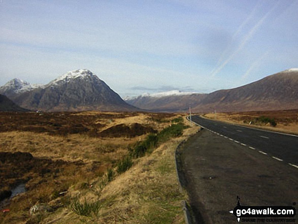
 Bidean nam Bian in Loch Leven to Connel Bridge, Strath of Orchy and Glen Lochy
Photo: Eric Smith
Is there a Mountain, Peak, Top or Hill missing from the above google map or list?
Let us know an we will add it to our database.

To contribute to go4awalk.com or to contact us about anything at all - see Talk To Us.
For help see Help.
go4awalk.com and go4awalk.co.uk are registered trademarks of TMDH Limited.
Copyright © 2000-2025 TMDH Limited. All rights reserved.
Copyright Terms & Conditions Privacy Statement
A - Z Walks Home Log On/Accounts Photo Gallery Walk Ideas and Collections Fell Facts Hill Skills Walking Questions and Answers Your Stories News Competitions Product Reviews/Gear Tests Walking Gear Guides Peaks and Mountains Peak Bagging Find New Walking Friends Camping GPS Waypoints for Walking Contents Walk Search Talk To Us go4awalk.com Help Free Example Walks Newsletter


