Scotland - a fully detailed list of all the Mountains, Peaks, Tops and Hills (Page 39 of 41)
If you count only the Marilyns there are 1218 tops to climb, bag & conquer and the highest point is Ben Nevis at 1,344m (4,411ft).
To see these Mountains, Peaks, Tops and Hills displayed in different ways - see the options in the left-hand column and towards the bottom of this page.
![]() Your Personal Bagging Record for Scotland
Your Personal Bagging Record for Scotland
LOG ON and RELOAD this page to show which Mountains, Peaks, Tops and Hills you have already climbed, bagged & conquered [. . . more details]
Page 39 of 41 First Previous 31 32 33 34 35 36 37 38 39 40 Next Last |
See this list in: Alphabetical Order
| Height Order‡
To reverse the order select the link again.
Mountain, Peak, Top or Hill:
Bagged

![]()
1141. Ward of Scousburgh
263m (863ft)
Ward of Scousburgh is on interactive maps:
A downloadable go4awalk.com PDF Peak Bagging Map featuring Ward of Scousburgh will be available soon. |
![]()
1142. Li a Tuarth (North Lee)
262m (860ft)
Send it in and we'll publish it here.
Li a Tuarth (North Lee) is on interactive maps:
A downloadable go4awalk.com PDF Peak Bagging Map featuring Li a Tuarth (North Lee) will be available soon. |
![]()
1143. Beinn Bhragair
261m (857ft)
Beinn Bhragair is on interactive maps:
A downloadable go4awalk.com PDF Peak Bagging Map featuring Beinn Bhragair will be available soon. |
![]()
1144. Creag an Amalaidh
261m (856ft)
Creag an Amalaidh is on interactive maps:
A downloadable go4awalk.com PDF Peak Bagging Map featuring Creag an Amalaidh will be available soon. |
![]()
1145. Woodhead Hill
258m (847ft)
Woodhead Hill is on interactive maps:
A downloadable go4awalk.com PDF Peak Bagging Map featuring Woodhead Hill will be available soon. |
![]()
1146. Airneabhal (Arnaval)
256m (840ft)
Send it in and we'll publish it here.
Airneabhal (Arnaval) is on interactive maps:
A downloadable go4awalk.com PDF Peak Bagging Map featuring Airneabhal (Arnaval) will be available soon. |
![]()
1147. Conostom
256m (840ft)
Conostom is on interactive maps:
A downloadable go4awalk.com PDF Peak Bagging Map featuring Conostom will be available soon. |
![]()
1148. Mount Eagle
256m (840ft)
Mount Eagle is on interactive maps:
A downloadable go4awalk.com PDF Peak Bagging Map featuring Mount Eagle will be available soon. |
![]()
1149. Beinn na h-Iolaire (Raasay)
254m (834ft)
Send it in and we'll publish it here.
Beinn na h-Iolaire (Raasay) is on interactive maps:
A downloadable go4awalk.com PDF Peak Bagging Map featuring Beinn na h-Iolaire (Raasay) will be available soon. |
![]()
1150. Burgiehill
254m (834ft)
Burgiehill is on interactive maps:
A downloadable go4awalk.com PDF Peak Bagging Map featuring Burgiehill will be available soon. |
![]()
1151. Cruach Lerags
252m (827ft)
Cruach Lerags is on interactive maps:
A downloadable go4awalk.com PDF Peak Bagging Map featuring Cruach Lerags will be available soon. |
![]()
1152. Dalescord Hill
252m (827ft)
Dalescord Hill is on interactive maps:
A downloadable go4awalk.com PDF Peak Bagging Map featuring Dalescord Hill will be available soon. |
![]()
1153. Torr Achilty
252m (827ft)
Torr Achilty is on interactive maps:
A downloadable go4awalk.com PDF Peak Bagging Map featuring Torr Achilty will be available soon. |
![]()
1154. Turin Hill
252m (827ft)
Turin Hill is on interactive maps:
A downloadable go4awalk.com PDF Peak Bagging Map featuring Turin Hill will be available soon. |
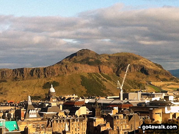
![]()
1155. Arthur's Seat
251m (824ft)
Arthur's Seat is on interactive maps:
A downloadable go4awalk.com PDF Peak Bagging Map featuring Arthur's Seat will be available soon. |
![]()
1156. Blotchnie Fiold
250m (821ft)
Blotchnie Fiold is on interactive maps:
A downloadable go4awalk.com PDF Peak Bagging Map featuring Blotchnie Fiold will be available soon. |
![]()
1157. Hightown Hill
250m (821ft)
Hightown Hill is on interactive maps:
A downloadable go4awalk.com PDF Peak Bagging Map featuring Hightown Hill will be available soon. |
![]()
1158. Sandness Hill
249m (817ft)
Sandness Hill is on interactive maps:
A downloadable go4awalk.com PDF Peak Bagging Map featuring Sandness Hill will be available soon. |
![]()
1159. Carn Ban (Mull)
248m (814ft)
Carn Ban (Mull) is on interactive maps:
A downloadable go4awalk.com PDF Peak Bagging Map featuring Carn Ban (Mull) will be available soon. |
![]()
1160. Muirneag
248m (814ft)
Muirneag is on interactive maps:
A downloadable go4awalk.com PDF Peak Bagging Map featuring Muirneag will be available soon. |
![]()
1161. Sleiteachal Mhor
248m (814ft)
Sleiteachal Mhor is on interactive maps:
A downloadable go4awalk.com PDF Peak Bagging Map featuring Sleiteachal Mhor will be available soon. |
![]()
1162. The Noup
248m (814ft)
The Noup is on interactive maps:
A downloadable go4awalk.com PDF Peak Bagging Map featuring The Noup will be available soon. |
![]()
1163. Easabhal (Easaval)
243m (798ft)
Easabhal (Easaval) is on interactive maps:
A downloadable go4awalk.com PDF Peak Bagging Map featuring Easabhal (Easaval) will be available soon. |
![]()
1164. Beinn Bhreac (Moidart)
240m (788ft)
Send it in and we'll publish it here.
Beinn Bhreac (Moidart) is on interactive maps:
A downloadable go4awalk.com PDF Peak Bagging Map featuring Beinn Bhreac (Moidart) will be available soon. |
![]()
1165. See Morris Hill
240m (788ft)
See Morris Hill is on interactive maps:
A downloadable go4awalk.com PDF Peak Bagging Map featuring See Morris Hill will be available soon. |
![]()
1166. Killyleoch Hill
240m (786ft)
Killyleoch Hill is on interactive maps:
A downloadable go4awalk.com PDF Peak Bagging Map featuring Killyleoch Hill will be available soon. |
![]()
1167. Waughton Hill
234m (768ft)
Waughton Hill is on interactive maps:
A downloadable go4awalk.com PDF Peak Bagging Map featuring Waughton Hill will be available soon. |
![]()
1168. Beinn Tart a' Mhill
232m (761ft)
Send it in and we'll publish it here.
Beinn Tart a' Mhill is on interactive maps:
A downloadable go4awalk.com PDF Peak Bagging Map featuring Beinn Tart a' Mhill will be available soon. |
![]()
1169. Maireabhal (Marrival)
230m (755ft)
Send it in and we'll publish it here.
Maireabhal (Marrival) is on interactive maps:
A downloadable go4awalk.com PDF Peak Bagging Map featuring Maireabhal (Marrival) will be available soon. |
![]()
1170. Cairnie Hill
228m (748ft)
Cairnie Hill is on interactive maps:
A downloadable go4awalk.com PDF Peak Bagging Map featuring Cairnie Hill will be available soon. |
Page 39 of 41 First Previous 31 32 33 34 35 36 37 38 39 40 Next Last |
View these 1218 Mountains, Peaks, Tops and Hills:
- On an Interactive Google Map (loads faster)
- On an Interactive Google Map with a list of tops below it.
(makes it easier to locate a particular top) - On a Detailed List in:
Alphabetical Order | Height Order - On one page with 'yet-to-be-bagged' listed 1st & then 'already-bagged' tops listed 2nd in:
Alphabetical Order | Height Order - On one page with 'already-bagged' tops listed 1st & then 'yet-to-be-bagged' tops listed 2nd in:
Alphabetical Order | Height Order
 The summit of Ben Nevis in Central ScotlandScotland
Photo: John Reed
Is there a Mountain, Peak, Top or Hill missing from the above google map or list?
Let us know an we will add it to our database.
To contribute to go4awalk.com or to contact us about anything at all - see Talk To Us.
For help see Help.
go4awalk.com and go4awalk.co.uk are registered trademarks of TMDH Limited.
Copyright © 2000-2026 TMDH Limited. All rights reserved.
Copyright Terms & Conditions Privacy Statement
A - Z Walks Home Log On/Accounts Photo Gallery Walk Ideas and Collections Fell Facts Hill Skills Walking Questions and Answers Your Stories News Competitions Product Reviews/Gear Tests Walking Gear Guides Peaks and Mountains Peak Bagging Find New Walking Friends Camping GPS Waypoints for Walking Contents Walk Search Talk To Us go4awalk.com Help Free Example Walks Newsletter


