The National Grid
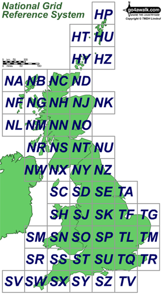
In order to reference any point in mainland Britain (England, Scotland and Wales) the area has been divided into a grid of 100km squares. Each square has then been given a unique two letter code (see right).
Each 100km x 100km square is then further subdivided into 1km x 1km lines which are overprinted on Ordnance Survey maps.
By further subdividing this 1km x 1km grid it is possible to give coordinates to any 100m x 100m square anywhere in the country using a 6 figure reference number.
Since this 6 figure reference number can be duplicated in each of the 100km x 100km squares, you must add the two letter grid identifier to make the grid reference truly unique.
For more details see Giving a Grid Reference.
To contribute to go4awalk.com or to contact us about anything at all - see Talk To Us. For help see Help.
go4awalk.com and go4awalk.co.uk are registered trademarks of TMDH Limited.
Copyright © 2000-2025 TMDH Limited. All rights reserved.
Copyright Terms & Conditions Privacy Statement
A - Z Walks Home Log On/Accounts Photo Gallery Walk Ideas and Collections Fell Facts Hill Skills Walking Questions and Answers Your Stories News Competitions Product Reviews/Gear Tests Walking Gear Guides Peaks and Mountains Peak Bagging Find New Walking Friends Camping GPS Waypoints for Walking Contents Walk Search Talk To Us go4awalk.com Help Free Example Walks Newsletter


