Ordnance Survey Walking Maps Required
All go4awalk.com walks are designed to be used in conjunction with the appropriate Ordnance Survey Map. Ordnance Survey maps contain more detail regarding contours, some local features and rights of way. go4awalk.com does not recommend that you venture into the hills without a suitable map and compass or without knowing how to use them.
The Ordnance Survey have produced four series of maps suitable for use in walking:
Explorer Maps: (Orange Covers) 1:25000 Scale (4cm to 1km or 2 1/2 inches to 1 mile)
Landranger Maps:(Pink Covers) 1:50000 Scale (2cm to 1km or 1 1/4 inches to 1 mile)
the older
Outdoor Leisure Maps*: (Yellow Covers) 1:25000 Scale (4cm to 1km or 2 1/2 inches to 1 mile)
and the even older
Pathfinder Maps**: (Green Covers) 1:25000 Scale (4cm to 1km or 2 1/2 inches to 1 mile)
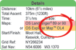
For example, walk c130 Steeple, Haycock and Caw Fell from Ennerdale suggests you use Ordnance Survey Landranger Map 89 or Ordnance Survey Explorer Map OL4.
While both maps offer sufficient detail to complete the walk the Ordnance Survey Explorer maps are larger scale and show more information - but cover a smaller area.
Walk c162 Stony Cove Pike and Hart Crag from Hartsop suggests using Ordnance Survey Landranger Map 90 or Ordnance Survey Explorer Maps OL5 & OL7.
This means you need either Ordnance Survey Landranger Map 90 or both Ordnance Survey Explorer Maps OL5 & OL7 because part of the walk is on Ordnance Survey Explorer Map OL5 and partly on Ordnance Survey Explorer Map OL7.
Walk c222 Swirl How and Wetherlam from Coniston suggests using Ordnance Survey Landranger Map 89/90 & 96/97 or Ordnance Survey Explorer Map OL6. Since Ordnance Survey Landranger Maps 89 and 90 overlap the middle part of that walk can be found on either map. Ordnance Survey Landranger Maps 96 and 97 also overlap so the first and last part of the walk can be found on either of those maps.
Therefore you could use Ordnance Survey Landranger Maps 89 & 96, 90 & 96, 89 & 97 or 90 & 97. (Since the whole walk appears on Ordnance Survey Explorer Map OL6 we suggest you use that one).
*The Outdoor Leisure series of maps has now been incorporated into the Explorer range (see below). The Explorer Maps covering areas in England and Wales use the same numbers but are prefixed with the letters OL and a yellow flash across the cover. For example 'Outdoor Leisure Map 7 - The English Lakes - South Eastern Area' is now Explorer Map OL7 - The English Lakes - South-eastern area'.
Outdoor Leisure Maps covering areas in Scotland have been replaced with Explorer Maps with completely new numbers.
** This series is being phased out and is not featured on go4awalk.com walks.


