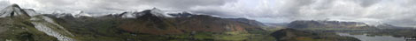
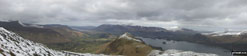
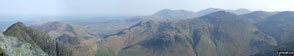
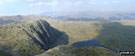
Cumbria, England - Panoramic Photographs and Pictures from local, easy-to-follow, circular walks

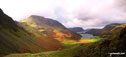
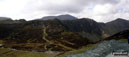
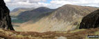
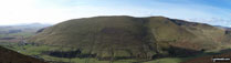
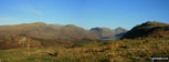
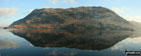
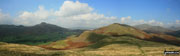
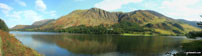
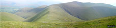
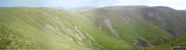
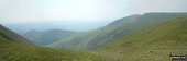
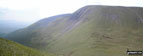
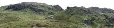
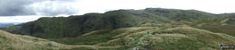
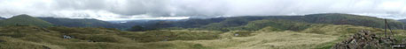
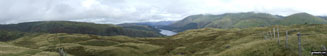
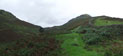
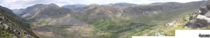
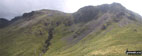
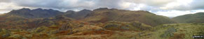
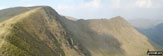
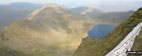
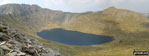
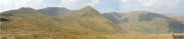
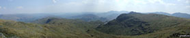
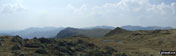
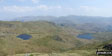
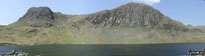
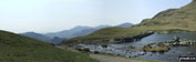
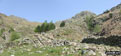
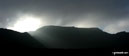
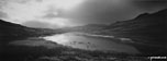
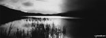
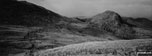
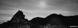
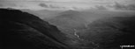
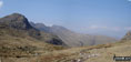
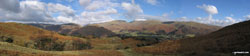
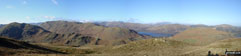
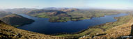
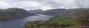
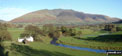
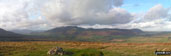
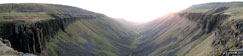
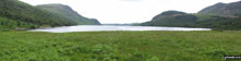
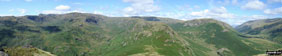
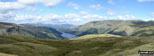
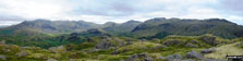
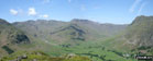
To find a walk route* to the locations featured in these pictures, click the thumbnail. The most recent pictures are at the top.
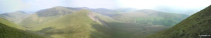
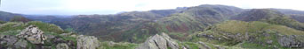
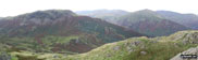
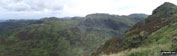
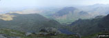
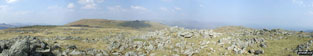
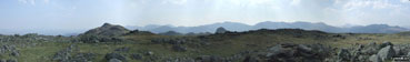
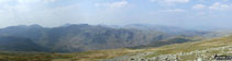
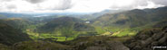
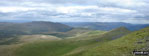
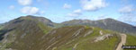
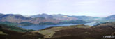

The flank of Hay Stacks (Haystacks), High Crag and High Stile (left), Mellbreak, Buttermere and Crummock Water (centre) with Grasmoor and High Snockrigg (right) from Fleetwith Pike   Hay Stacks (Haystacks) from Dubs Quarry on Fleetwith Pike   Grasmoor, Robinson and Fleetwith Pike and Buttermere from Hay Stacks (Haystacks)   Bowscale Fell from Carrock Fell   Rossett Crag, Black Crags, Mart Crag, Pike of Stickle, The Langdale Pikes, Mickleden and Great Langdale from The Climbers' Traverse below Bow Fell (Bowfell)   Elterwater in the grip of winter   Mickelden Beck flowing through Great Langdale with the lowers slopes of the Landale pikes (left) and Side Pike (right)   Barrow and Rowling End, with Keswick and Derwent Water beyond and Skiddaw and Blecathra (or Saddleback) in the background from Causey Pike   Swine Crag, Riggendale, Kidsty Pike and Kidsty Howes in the snow   The Kentmere Horseshoe (Yoke, Ill Bell, Froswick, Thornthwaite Crag, Kentmere Pike and Shipman Knotts) from Hollow Moor   Wasdale Head (Yewbarrow, Kirk Fell and Great Gable), Whin Rigg and Eskdale Moor from Irton Pike   The Westerly aspect from Hollow Moor includes a distant view of Crinkle Crags with Yoke, Ill Bell, Froswick and Thornthwaite Crag above Kentmere   Seatallan, Great Scoat Fell, Little Scoat Fell, Red Pike (Wasdale), Yewbarrow, Kirk Fell, Great Gable and Whin Rigg from Irton Pike   High Dodd (Sleet Fell) and Place Fell across Ullswater from Mossdale Bay near Glenridding   The Dunnerdale Horseshoe - featuring Stickle Pike (Dunnerdale Fells), Great Stickle, The Knott (Dunnerdale Fells) and Raven's Crag   High Snockrigg and Robinson across Buttermere   The Arten Gill Beck railway viaduct and Wold Fell from near Cowgill   Hallsfell Top Ridge rising to Hallsfell Top (the summit of Blencathra or Saddleback) from Atkinson Pike at the top of Sharp Edge   Cross Keys and The River Rawthey valley from Pickering Gill below Great Dummacks   Cautley Crag, Cautley Spout, Yarlside, Cautley Holme Beck, and Cross Keys from Great Dummacks   Sickers Fell, Rowantree Grains and Arant Haw from Calders   The Calf and Calders from Fell Head (Howgills)   Linghaw behind Fell Head (Howgills) from near The Calf   Yarlside from Kensgriff   West Fell, Hooksey, Randygill Top, Kensgriff and Wandale Hill from Yarlside   Grasmere, Silver How, Lang How, Blea Rigg, Easedale Tarn, The LAngdale Pikes, Codale Head, Gibson Knott and Calf Crag from Helm Crag summit cairn   Steel Fell (left) and Seat Sandal (right) from Helm Crag   Deer Bields from Gibson Knott   Deer Bields, Ferngill Crag and Broadstone Head from Calf Crag   Broadstone Head from Brownrigg Moss   Steel Fell, Gibson Knott and Helm Crag below Seat Sandal (with Helvellyn and Fairfield in mist beyond) from Tarn Crag summit cairn   Grasmere, Easedale Tarn and Blea Rigg from Tarn Crag summit   Broadstone Head   Broadstone Head, Ferngill Crag and Deer Bields from Brownrigg Moss   Helm Crag, Gibson Knott, Calf Crag, Greenup Edge and The Wythburn Fells from Steel Fell (Dead Pike) summit cairn   The Wythburn Fells (left) Thirlmere, Helvellyn (in mist) and Seat Sandal (right) from Steel Fell (Dead Pike)   Helm Crag (left) and Steel Fell from Greenburn Bottom   The view north from Looking Stead (Pillar) featuring Ennerdale with Red Pike (Buttermere), High Stile, High Crag, Seat, Scarth Gap, Hay Stacks (Haystacks) and Brandreth (far right)   Kirk Fell (East Top) (left) and Kirk Fell from Black Sail Pass   From left to right: Slight Side and Sca Fell, Mickledore, Scafell Pike, Ill Crag and Great End, Esk Hause, Esk Pike, Bow Fell (Bowfell), Crinkle Crags (Long Top), Cold Pike, Little Stand and finally the shoulder of Grey Friar from the summit of Hard Knott   Eskdale from Birker Force (Waterfall) with Illgill Head (centre left) and Sca Fell (centre right) on the horizon   Lingmell (far right), Scafel Pike, Mickledore, Sca Fell and Illgill Head (centre right) from across Overbeck Bridge, Wast Water   Yewbarrow, Great Gable, Lingmell, Scafell Pike and Sca Fell from Wast Water   Yewbarrow, Wasdale Head, Wast Water, Lingmell, Scafell Pike, Mickledore and Sca Fell, Illgill Head and Whin Rigg from below Middle Fell (Wasdale)   The Scafell Massif, Illgill Head, Whin Rigg and the Wast Water Screes from Buckbarrow   Loweswater from the cairn on the North West end of the Carling Knott ridge   Hartsop above How, Hart Crag and Fairfield from Deepdale Hause   Nethermost Pike, Helvellyn and Striding Edge (High Spying How) from High Crag (Helvellyn)   Helvellyn and Striding Edge (High Spying How) from Nethermost Pike   Swirral Edge, Catstye Cam and Red Tarn from Helvellyn   Helvellyn, Red Tarn, Swirral Edge and Catstye Cam from Striding Edge (High Spying How)   Striding Edge (High Spying How), Helvellyn, Swirral Edge and Catstye Cam from Hole-in-the-Wall   High Spy (North Top), High Spy, Maiden Moor, Hindscarth (left), Robinson, Crag Hill (Eel Crag), Causey Pike, Barrow (Newlands) (centre), Newlands, Bassenthwaite Lake, Swinside, Skiddaw, Derwent Water and Blencathra (right) beyond from Cat Bells (Catbells)   Causey Pike (left), Bassenthwaite Lake, Newlands, Swinside, Cat Bells (Catbells) (centre), Derwent Water, Skiddaw , Blencathra and Walla Crag (far right) from Maiden Moor   *Loft Crag (foreground far left), Lingmoor, Blea Tarn, Pike of Blisco (Pike o' Blisco), Cold Pike and Crinkle Crags (featuring Crinkle Crags (South Top), Crinkle Crags (Long Top) and Gunson Knott) (mid-distance left to right) and Wetherlam, Great Carrs and Grey Friar (far-distance centre to right)  from the summit of Pike of Stickle (Langdale Pikes)   *Pavey Ark and Stickle Tarn with the Blea Ridge beyond from Harrison Stickle Summit (Langdale Pikes)   *Stickle Tarn with Great Langdale and Lingmoor beyond from Pavey Ark Summit (Langdale Pikes)   *High Raise (Langdale) and Seargent Man (dark pimple left of centre) and Codale Head from Thunacar Knott   *Harrison Stickle (left) and Pike of Stickle (right) and the Langdale Pikes Plateau from Thunacar Knott   *Scafell Pike (far left back) and The Borrowdale Fells featuring Allen Crags, High House Tarn Top, Red Beck Top, Looking Stead, Glaramara, Comb Head, Comb Door Top, Dovenest Top and Rosthwaite Fell (Bessyboot) from High Raise (Langdale)   *The view from Sergeant Man featuring Blea Rigg (centre left), Lingmoor Fell (centre distance), Stickle Tarn (partially hidden) and Pavey Ark with Harrison Stickle beyond (The Langdale Pikes) (centre right)   *The view from Codadle Head featuring Pavey Ark (The Langdale Pikes) (centre left) and Sergeant Man (centre right)   *Codale Tarn (left) and Easedale Tarn from the Blea Rigg ridge with Helvellyn (left), Seat Sandal (centre) and Fairfield (right) on the horizon   *Harrison Stickle and Pavey Ark (The Langdale Pikes) from Stickle Tarn   *Stickle Tarn dam and outflow (The Langdale Pikes)   *Starting up Stickle Ghyll from Great Langdale with Harrison Stickle (The Langdale Pikes) (far left)   *Striding Edge (High Spying How) (left), Helvellyn, Swirral Edge and Catstye Cam (far right) from near Hole-in-the-wall   Red Tarn (Langdale)   Red Tarn (Langdale)   Great Knott from Red Tarn (Langdale)   The Crinkle Crags ridge featuring Gunson Knott, Crinkle Crags (Long Top) and Crinkle Crags (South Top)   North from the summit of Bow Fell (Bowfell)   *360° Panoroma from the summit of Loughrigg Fell   Blea Rigg, Castle How, Lang How and Silver How (far left) Great Langdale, Windermere and Elter Water (left), Lingmoor Fell and Side Pike (centre left), Blea Tarn and Little Langdale (centre right), Pike of Blisco (Pike o' Blisco) right and Crickle Crags (far right) from the summit of Harrison Stickle, The Langdale Pikes   *Southeastern panorama from the summit of Skiddaw with Blencathra and Blease Fell silhouetted left of centre   *360° panorama from the summit of Scar Crags   *Looking back along Scar Crags to Sail (Derwent Fells) and Crag Hill (Eel Crag) from Causey Pike   *Derwent Water from Bleaberry Fell   *Great Knott, Crinckle Crags and Bow Fell (Bowfell) from the Red Tarn (Langdale)   *360 Degree Panorama from the summit of Red Screes   *Lakeland panorama featuring a snow-topped Helvellyn (centre left) and Fairfield (centre right) from above Grasmere   *Beda Head (Beda Fell) with Place Fell beyond (left), Ullswater and Hallin Fell (right) from Steel Knotts (Pikeawassa)   *Ullswater from Bonscale Pike   *Place Fell, Ullswater and Glencoyne Park from Gowbarrow Fell (Airy Crag)   *Looking across St John's in the Vale to Blencathra   *Blencathra and the Northern Fells from the summit of Great Mell Fell   *High Cup from The Pennine Way   *High Cup with Murton Fell beyond from The Pennine Way   Great Gable (mid-distance right) with The Scafell Massif beyond with Esk Pike (left) and Bow Fell (Bowfell) (far left) from Littledale Edge   *Pillar (left), High Stile (centre), Ennerdale, Hay Stacks, Crummock Water, Buttermere and Grasmoor (right) from  Green Gable   *Baystones (Wansfell) in the foreground with Red Screes (left), Stony Cove Pike (Caudale Moor), Thornthwaite Crag and the Froswick, Ill Bell, Yoke ridge silhouetted on the skyline from Wansfell Pike   Dollywaggon Pike (right) with The Langdale Pikes (mid distance) and Bow Fell (Bowfell) and
Scafell Pike (far distance) from St Sunday Crag   *Barf and Crummock Water from Dodd (Skiddaw)   *Grasmoor (left of centre) and Red Pike (Buttermere) (right of centre) from Great Borne   *Ennerdale Water (left), Starling Dodd and Great Borne, Loweswater (right of centre), Mellbreak and Crummock Water (right) from Red Pike (Buttermere)   *Angler's Crag across Ennerdale Water   *Grasmere Common, Easedale and The Greenburn Horseshoe from Helm Crag   *Thirlmere from the summit of Steel Fell (Dead Pike)   *Northernly Panorama from the summit of Hard Knott featuring Sca Fell, Scafell Pike, Esk Pike, Bow Fell (Bowfell), Gunson Knott, Crinkle Crags (Long Top) and Crinkle Crags (South Top)   *Kettle Crag (left), Oxendale, The Band (centre - with Crinkle Crags (Crinkle Crags (South Top), Crinkle Crags (Long Top), & Gunson Knott) (top left) and Bow Fell (Bowfell) (top right), Mickleden and The Langdale Pikes from Side Pike  


*where available

Send us your photographs and pictures of walks and hikes in the British countryside

If you would like to see your digital photographs as part of this collection, please send them as email attachments (configured for any computer) along with your name to:

and we shall do our best to publish them.

(Guide Resolution = 300dpi. At least = 587 pixels (wide) x 440 pixels (high).)

Send us your walking and hiking photographs and pictures via Facebook

You can also submit photos via our Facebook Page.

NB. Please indicate where each photo was taken.

NB. To see photographs and pictures from a particular walk choose your walk from Walks or use our Walk Search facility.

To see photographs and pictures on, of or from a particular Mountain, Peak, Top or Hill select from Peaks & Mountains' or enter the Mountain, Peak, Top or Hill Name into our 'Photo Search facility.


Do not miss our pick of the Best Walks in Britain


Follow go4awalk.com on Twitter Follow go4awalk.com on Facebook


Home


Find new Friends to go walking with

Walk all 214 Wainwrights in just 59 Walks. Download GPS Waypoints - Great Walks you must not miss!

Walk The Yorkshire Three Peaks Challenge Walk - All the Latest Route Information, GPS Waypoints and Split Times to keep you on Schedule

Walk The British Three Peaks Challenge Walk - All the Latest Route Information and GPS Waypoints

See our pick of The Best Walks in The Lake District - Great Walks you must not miss!

Walk our pick of the Best Lake District Ridge Walks - Great Walks you must not miss!

Walk our pick of the Best Lake District Walks to do in the rain - Great Walks you must not miss!

Walk our pick of The Best Walks in Snowdonia - Great Walks you must not miss!

Walk our pick of The Best Ridge Walks in Wales - Walks you must not miss!

Walk our pick of The Best Walks in The Brecon Beacons - Great Walks you must not miss!

Walk our pick of The Best Walks in The Yorkshire Dales - Walks you must not miss!

Walk our pick of The Best Walks in The Peak District - Walks you must not miss!

Walk our pick of The Best Walks in The Forest of Bowland - Walks you must not miss!

Walk our pick of The Best Walks in Shropshire - Walks you must not miss!

Walk our pick of The Best Walks in Cheshire - Walks you must not miss!

Walk our pick of The Best Walks in Lancashire - Walks you must not miss!

Not sure where to walk next? Try Peak Bagging - Great Walks you must not miss!

Not sure where to walk next? Walk part of a National Trail - Great Walks you must not miss!

Walks with Downloadable and Uploadable GPS Waypoint Data

Walking Kit and Gear Tested by Walkers

Full Site Search
Do not miss our pick of the Best Walks in Britain