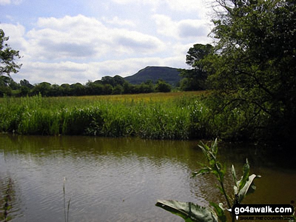
The Cloud (Bosley Cloud) from The Macclesfield Canal
Cheshire, England
See views like this by using any of these 11 easy-to-follow circular walk route maps:
   |
Vital Statistics:
| Length: | 4.5 miles (7 km) |
| Ascent: | 66ft (20m) |
| Time: | 1½ hrs |
| Grade: |  |
Route Summary:
Oakgrove - The Macclesfield Canal - The Cheshire Ring Canal Walk - Gawsworth - Oakgrove
|
Vital Statistics:
| Length: | 5.5 miles (9 km) |
| Ascent: | 115ft (35m) |
| Time: | 2.25hrs |
| Grade: | |
Route Summary:
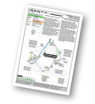
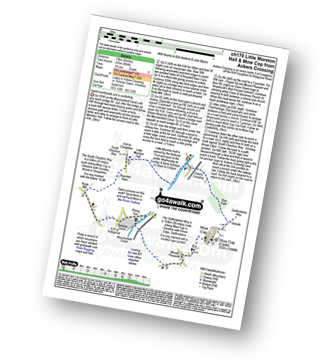
Ackers Crossing - The Macclesfield Canal - The Cheshire Ring Canal Walk - Little Moreton Hall - Boarded Barn Farm - Rode Mill - Claphatches - Scholar Green - The Macclesfield Canal - Ackers Crossing
|
Vital Statistics:
| Length: | 4.5 miles (7 km) |
| Ascent: | 341ft (104m) |
| Time: | 2 hrs |
| Grade: |  |
Route Summary:
Bosley Locks - The Macclesfield Canal - The Cheshire Ring Canal Walk - River Dane Aquaduct - Railway Viaduct - Crossley Farm - Colleymill Bridge - North Rode - North Rode Manor Fish Pond - Station Wood - Big Dogbottom Wood - Bosley Locks
|
Vital Statistics:
| Length: | 4.5 miles (7 km) |
| Ascent: | 266ft (81m) |
| Time: | 2 hrs |
| Grade: | |
Route Summary:
Gurnett - The Macclesfield Canal - The Cheshire Ring Canal Walk - Oakgrove - Sutton Reservoir - Sutton Grange - Gurnett
|
Vital Statistics:
| Length: | 5.5 miles (9 km) |
| Ascent: | 689ft (215m) |
| Time: | 2.75hrs |
| Grade: |  |
Route Summary:
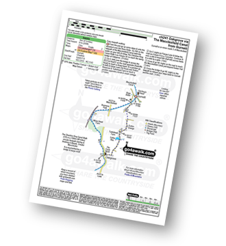
Ackers Crossing - The Macclesfield Canal - The Cheshire Ring Canal Walk - Scholar Green - Mount Pleasant - Mow Cop (Old Man of Mow) - The Gritstone Trail - The Staffordshire Way - The South Cheshire Way - Quarry Wood - Hanging Wood - Roe Park - Ackers Crossing
|
Vital Statistics:
| Length: | 7.25 miles (11.5 km) |
| Ascent: | 404ft (123m) |
| Time: | 3 hrs |
| Grade: | |
Route Summary:
North Rode - Gawsworth - Oakgrove - The Macclesfield Canal - The Cheshire Ring Canal Walk - Bosley Locks - Big Dogbottom Wood - Station Wood - North Rode Manor Fish Pond - North Rode
|
Vital Statistics:
| Length: | 8.25 miles (13 km) |
| Ascent: | 804ft (245m) |
| Time: | 3.75hrs |
| Grade: |  |
Route Summary:
Ackers Crossing - The Macclesfield Canal - The Cheshire Ring Canal Walk - Little Moreton Hall - Boarded Barn Farm - Rode Mill - Claphatches - Scholar Green - Mount Pleasant - Mow Cop (Old Man of Mow) - The Gritstone Trail - The Staffordshire Way - The South Cheshire Way - Quarry Wood - Hanging Wood - Roe Park - Ackers Crossing
|
Vital Statistics:
| Length: | 9.25 miles (15 km) |
| Ascent: | 545ft (166m) |
| Time: | 4 hrs |
| Grade: | |
Route Summary:
Gawsworth - Oakgrove - The Macclesfield Canal - The Cheshire Ring Canal Walk - Bosley Locks - River Dane Aquaduct - Railway Viaduct - Crossley Farm - Colleymill Bridge - North Rode - Manor Farm - Beancroft Wood - Rodegreen Farm - Gawsworth
|
Vital Statistics:
| Length: | 7 miles (11 km) |
| Ascent: | 824ft (251m) |
| Time: | 3.25hrs |
| Grade: | |
Route Summary:
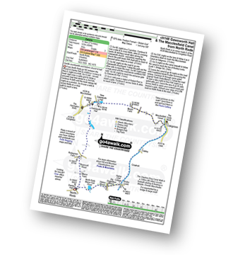
Nelson Pit Visitors Centre - Higher Poynton - The Macclesfield Canal - The Cheshire Ring Canal Walk - Wood Lanes - Adlington Basin - Lockgate Farm - The North Cheshire Way - Harrop Brow - West Parkgate - Lyme Park Country Park - Lyme Park Car Park - The Cage - Lyme Hall - Fallow Deer Park - The Lime Avenue - Lyme Park Car Park - Windgather Farm - Haresteads Farm - Nelson Pit Visitors Centre - Higher Poynton.
|
Vital Statistics:
| Length: | 9.75 miles (15.5 km) |
| Ascent: | 9ft (409m) |
| Time: | 5 hrs |
| Grade: |  |
Route Summary:
Nelson Pit Visitors Centre - Higher Poynton - The Macclesfield Canal - The Cheshire Ring Canal Walk - Wood Lanes - Adlington Basin - Lockgate Farm - The North Cheshire Way - Harrop Brow - Birchencliff Farm - Keeper's Cottage - Dale Top - Sponds Moor - The Gritstone Trail - Sponds Hill - Bowstonegate Farm - Bow Stones - Higher Moor - Lyme Park Country Park - Lantern Wood - The Cage - Lyme Hall - Fallow Deer Park - The Lime Avenue - Lyme Park Car Park - Windgather Farm - Haresteads Farm - Nelson Pit Visitors Centre - Higher Poynton.
|
Vital Statistics:
| Length: | 9 miles (14.5 km) |
| Ascent: | 1,208ft (368m) |
| Time: | 4½ hrs |
| Grade: | |
Route Summary:
Timbersbrook - The Gritstone Trail - Pool Bank - The Staffordshire Way - Folly Cottage - Cloud Plantation - The Cloud (Bosley Cloud) - Avona - The Dane Valley Way - River Dane - The Macclesfield Canal - The Cheshire Ring Canal Walk - Buglawton - Brook House Farm - Pool Bank - Timbersbrook
Send us your photographs and pictures of walks and hikes in the British countryside
If you would like to see your digital photographs as part of this collection, please send them as email attachments (configured for any computer) along with your name to:
and we shall do our best to publish them.
(Guide Resolution = 300dpi. At least = 587 pixels (wide) x 440 pixels (high).)

You can also submit photos via our Facebook Page.
NB. Please indicate where each photo was taken.
NB. To see photographs and pictures from a particular walk choose your walk from Walks or use our Walk Search facility.
To see photographs and pictures on, of or from a particular Mountain, Peak, Top or Hill select from Peaks & Mountains' or enter the Mountain, Peak, Top or Hill Name into our 'Photo Search facility.


