The Mountains, Peaks, Tops and Hills in The Ben Lomond Area of Scottish Region 1: Scottish Region 1: The Firth of Clyde to Strath Tay with all the tops you have already bagged first & then the ones you are yet to climb second.
The Ben Lomond Area of Scottish Region 1: The Firth of Clyde to Strath Tay region is the area enclosed by an imaginary line connecting:
- Inversnaid to Callander via Loch Arklet, Loch Katrine, Loch Achray and Loch Venachar to the North
- Callander to Stirling via the A84 though Doune to the East
- Stirling to Loch Lomond via the A811 through Kippen & Drymen to the South
- Loch Lomond to Inversnaid to the West
If you include all the Munros, the Corbetts, the Grahams, the Donalds, the Murdos, the Marilyns, the Bridgets (Hills), and all the Mountains, Tops, Peaks and Hills with a Trig Point on them there are 11 tops to climb, bag & conquer and the highest point is Ben Lomond at 974m (3,196ft).
To see these Mountains, Peaks, Tops and Hills displayed in different ways - see the options in the left-hand column and towards the bottom of this page.
![]() Your Personal Bagging Record for The Ben Lomond Area of Scottish Region 1: The Firth of Clyde to Strath Tay
Your Personal Bagging Record for The Ben Lomond Area of Scottish Region 1: The Firth of Clyde to Strath Tay
When logged on, you can mark each Mountain, Peak, Top or Hill as 'bagged' by either:
- if you opt to display the tops in this area using a google map, click or tap on its symbol on the map below. This will open a text window. Click or tap on the 'Record [mountain name] as Bagged, Climbed & Conquered' link towards the bottom of the text window, or
- if you opt to display the tops in this area as a list, click or tap on the red 'not yet' symbol to the right of the name of each 'top'
Either method will open a new page where you can complete all your details such as:
- when you bagged the Mountain, Peak, Top or Hill;
- which route you took
- who you went with
- what the weather was like
- any other comment that will remind you of the day
Once you have completed your details and click or tap the submit button, you will automatically return to this page and the top you bagged will show with a green tick.
NB. None of the above fields are 'mandatory' - you can leave them blank if you wish.
NNB. You also have the option whether to display your peak bagging exploits to other users of this site or keep them private so only you can see them when you are logged on.
Furthermore, since you can also access your Personal Mountain & Hill Bagging Record via go4awalk Mobile you can quickly & easily record, edit and view your achievements - whether you are at home/work on your desktop computer or in the pub/at the top of a mountain with your Mobile Phone. (You can even download your Personal Mountain & Hill Bagging Record as a .csv file for importing into and saving with spreadsheet software like Excel or NeoOffice!)
This facility costs one credit to initially access your personal bagging record. Once accessed, all other interactions, such as recording other Mountains, Peaks, Tops and Hills as 'bagged' or altering an existing bagging record, are free.
Click REGISTER to register and purchase credits.
LOG ON and RELOAD this page to show which Mountains, Peaks, Tops and Hills you have already climbed, bagged & conquered. [ . . . remove this text]
Scroll down this list of mountains, peaks, tops & hills below and tap/click on each name (in blue) to locate it on the map above.
See this list in: Alphabetical Order | Height Order‡
To reverse the order select the link again.
Mountain, Peak, Top or Hill already bagged:
Bagged
Top yet to be climbed, bagged & conquered:
Bagged

![]()
1. Ben Lomond
974m (3196ft)
Munro, Murdo, Marilyn and Trig Point
See more details, photos, trip reports and easy-to-follow walks up Ben Lomond

![]()
2. Ben Venue
729m (2393ft)
Graham, Marilyn and Trig Point
See more details, photos, trip reports and easy-to-follow walks up Ben Venue

![]()
3. Cruinn a' Bheinn
632m (2074ft)
Graham and Marilyn
See more details, photos, trip reports and easy-to-follow walks up Cruinn a' Bheinn

![]()
4. Beinn Uamha
597m (1959ft)
Marilyn
See more details, photos, trip reports and easy-to-follow walks up Beinn Uamha
![]()
5. Beinn Uird
597m (1959ft)
Marilyn
See more details, photos, trip reports and easy-to-follow walks up Beinn Uird
![]()
6. Binnean nan Gobhar
586m (1923ft)
Marilyn
See more details, photos, trip reports and easy-to-follow walks up Binnean nan Gobhar

![]()
7. Beinn Bhreac (Lochard Forest)
579m (1900ft)
Bridget and Trig Point
See more details, photos, trip reports and easy-to-follow walks up Beinn Bhreac (Lochard Forest)
![]()
8. Beinn Dubh (Loch Chon)
508m (1667ft)
Marilyn
See more details, photos, trip reports and easy-to-follow walks up Beinn Dubh (Loch Chon)
![]()
9. Beinn Dearg (Loch Venachar)
427m (1401ft)
Marilyn
See more details, photos, trip reports and easy-to-follow walks up Beinn Dearg (Loch Venachar)

![]()
10. Craig of Monievreckie
400m (1313ft)
Marilyn and Trig Point
See more details, photos, trip reports and easy-to-follow walks up Craig of Monievreckie
![]()
11. Conic Hill
361m (1184ft)
Marilyn
See more details, photos, trip reports and easy-to-follow walks up Conic Hill
![]() Your Personal Bagging Record for The Ben Lomond Area of Scottish Region 1: The Firth of Clyde to Strath Tay
Your Personal Bagging Record for The Ben Lomond Area of Scottish Region 1: The Firth of Clyde to Strath Tay
When logged on, you can mark each Mountain, Peak, Top or Hill as 'bagged' by either:
- if you opt to display the tops in this area using a google map, click or tap on its symbol on the map below. This will open a text window. Click or tap on the 'Record [mountain name] as Bagged, Climbed & Conquered' link towards the bottom of the text window, or
- if you opt to display the tops in this area as a list, click or tap on the red 'not yet' symbol to the right of the name of each 'top'
Either method will open a new page where you can complete all your details such as:
- when you bagged the Mountain, Peak, Top or Hill;
- which route you took
- who you went with
- what the weather was like
- any other comment that will remind you of the day
Once you have completed your details and click or tap the submit button, you will automatically return to this page and the top you bagged will show with a green tick.
NB. None of the above fields are 'mandatory' - you can leave them blank if you wish.
NNB. You also have the option whether to display your peak bagging exploits to other users of this site or keep them private so only you can see them when you are logged on.
Furthermore, since you can also access your Personal Mountain & Hill Bagging Record via go4awalk Mobile you can quickly & easily record, edit and view your achievements - whether you are at home/work on your desktop computer or in the pub/at the top of a mountain with your Mobile Phone. (You can even download your Personal Mountain & Hill Bagging Record as a .csv file for importing into and saving with spreadsheet software like Excel or NeoOffice!)
This facility costs one credit to initially access your personal bagging record. Once accessed, all other interactions, such as recording other Mountains, Peaks, Tops and Hills as 'bagged' or altering an existing bagging record, are free.
Click REGISTER to register and purchase credits.
LOG ON and RELOAD this page to show which Mountains, Peaks, Tops and Hills you have already climbed, bagged & conquered. [ . . . remove this text]
View these 11 Mountains, Peaks, Tops and Hills:
- On an Interactive Google Map with a list of tops below it.
(makes it easier to locate a particular top) - On a Detailed List in:
Alphabetical Order | Height Order - On one page with 'yet-to-be-bagged' listed 1st
& then 'already-bagged' tops listed 2nd in:
Alphabetical Order | Height Order - On one page with 'already-bagged' tops listed 1st
& then 'yet-to-be-bagged' tops listed 2nd in:
Alphabetical Order | Height Order
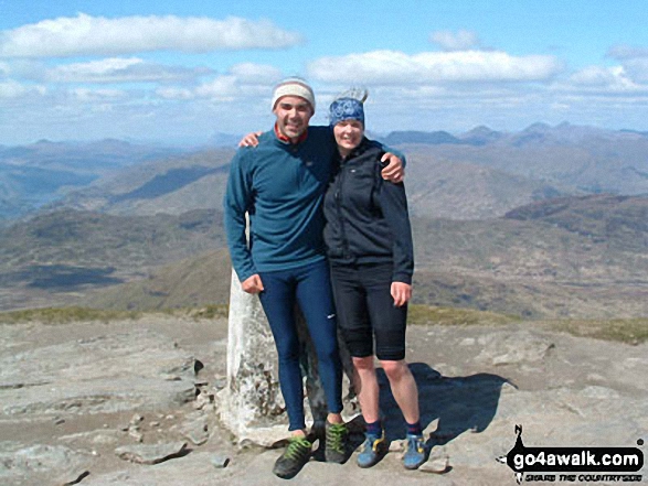 The summit of Ben Lomond in The Firth of Clyde to Strath Tay
Photo: Heather Meek
Is there a Mountain, Peak, Top or Hill missing from the above google map or list?


