Walk Photographs and views from British Walks published during 2023


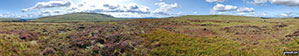
Wild Bank Hill (Hollingworthhall Moor) Summit Trig Point


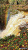
Mary Stanford Lifeboat House, Rye

Windmill and buildings of Rye from Rye Harbour

Jill Windmill (of The Jack and Jill Windmills) above Clayton

South Downs Way signpost near The Jack and Jill Windmills above Clayton


Halton Gill Bridge over the River Skilfare


The River Skilfare between Foxup and Halton Gill

One of the Harrop Barns with Horse Head beyond

Another one of the Harrop Barns

Some of the Harrop Barns with Wensleydale beyond

One of the Harrop Barns with Horse Head beyond

Ruined Harrop Barn with Horse Head in the background


Plover Hill and Pen-y-ghent from the summit of Blaydike Moss

The small cairn on the summit of Blaydike Moss

High Green Field Knott from Cosh Water Gap


Dry stone wall snaking its way up High Green Field Knott

Trig Point on High Green Field Knott with Plover Hill and Pen-y-ghent in the background
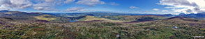
Panorama from the summit of Blaydike Moss

Plover Hill (centre) and Pen-y-ghent (right) from High Green Field Knott

The actual summit of High Green Field Knott (Cosh Knott)

Littondale from High Green Field Knott

Looking towards Horse Head Moor from High Green Field Knott


Descending back towards Halton Gill from Horse Head with Fountains Fell dominating the skyline

Choice of paths above Halton Gill

The former church in Halton Gill
There were a lot of flying insects on the summit of Moel Eilio (Dolgarrog)!
There were a lot of flying insects on the summit of Moel Eilio (Dolgarrog)!
Panorama from the summit of Moel Eilio (Dolgarrog)

Grassy summit of Moel Eilio (Dolgarrog)


Broken fence on the way up Moel Eilio (Dolgarrog)

Information Board on the Water Treatment Works access road above Pont Dolgarrog


Water channel on Tai-isaf-ardda

Couple of bridges over a 2nd water channel on Tai-isaf-ardda

Small waterfall in Cwm Afon Ddu

The reservoir access road crossing a stream in Cwm Afon Ddu

The Llyn Cowlyd Reservoir pipeline in Cwm Afon Ddu


Approaching Moel Eilio (Dolgarrog)

Coedty Reservoir and the Conwy Valley from Moel Eilio (Dolgarrog)

Helicopter hovering above Pen Llithrig y Wrach from Cwm Afon Ddu

The Llyn Cowlyd Reservoir pipeline with Creigiau Gleision beyond


Cefn Cyfarwydd from the summit of Moel Eilio (Dolgarrog)!

Moel Eilio (Dolgarrog) from Cwm Afon Ddu

The trig point on the summit of Mynydd Carn-y-cefn


Y Foel Goch (centre) and Tryfan (right) from Gallt yr Ogof

Y Foel Goch (centre left) and Tryfan (right) from Gallt yr Ogof


Moel Ymenyn from Craig y Bychau

Arenig Fawr (Moel Yr Eglwys) from the summit of Moel Ymenyn


Swirral Edge and Helvellyn from the summit cairn on Catstye Cam


High Seat (Ashness Fell) summit trig point


On Raven Crag (Thirlmere) with a broken arm


Ling Fell from the summit of Sale Fell

Me beside the trig point on the summit of Ling Fell (Wythop)

Ling Fell (Wythop) summit cairn


Wainwright's Low Fell summit cairn

The true summit of Low Fell summit


Rannerdale Knotts summit cairn

The view from Rannerdale Knotts summit cairn

Memorial Plaque on the summit of Castle Crag


Steel Fell (Dead Pike) summit cairn


The summit cairn on Fleetwith Pike

White cross memorial to Fanny Mercer near the bottom of Fleetwith Pike near Gatescarth

The Nab (Martindale) summit cairn

Bluebells on Rannerdale Knotts


The view from Brae Fell summit cairn

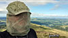
Me on the summit of Longlands Fell

Derwent Water and Keswick from Latrigg

Little Mell Fell summit trig point

Great Mell Fell summit cairn and post

Fell ponies on Great Mell Fell

Ullswater from the summit cairn on Glenridding Dodd

Glenridding Dodd from the lower slopes of Sheffield Pike


Raise (Helvellyn) summit cairn


Lower Man (Helvellyn) summit cairn


Peaks and Northern Footpaths Society Sign for Footpath No. 452 to Newchurch Common

The Whitegate Way - a former railway line

Moel Penderyn Summit Trig Point emblazoned with a Welsh Dragon

Welsh Dragon on the Trig Point located on the summit of Moel Penderyn

Sculptured owl on the lanes outside Higher Walton

Snowdrops in woods on the outskirts of Higher Walton


Cheshire countryside near Frodsham

Helsby Hill National Trust area

Sandstone Cliff near Bakers Dozen steps, Helsby Hill National Trust area

Sandstone Cliffs, Helsby Hill National Trust area

Snidley Moor Wood, Helsby Hill National Trust area

The view north towards Liverpool from the summit of Helsby Hill

To contribute to go4awalk.com or to contact us about anything at all - see Talk To Us.
For help see Help.
go4awalk.com and go4awalk.co.uk are registered trademarks of TMDH Limited.
Copyright © 2000-2026 TMDH Limited. All rights reserved.
Copyright Terms & Conditions Privacy Statement
A - Z Walks Home Log On/Accounts Photo Gallery Walk Ideas and Collections Fell Facts Hill Skills Walking Questions and Answers Your Stories News Competitions Product Reviews/Gear Tests Walking Gear Guides Peaks and Mountains Peak Bagging Find New Walking Friends Camping GPS Waypoints for Walking Contents Walk Search Talk To Us go4awalk.com Help Free Example Walks Newsletter


