Walk Photographs and views from British Walks published during 2017

Preparing for the climb up Pillar Rock

Taking a breather on 'the slab' - about a third of the way up Pillar Rock


The cairn on the summit of Pillar Rock


At the bottom of the abseil off Pillar Rock


The view from the summit of The Pike (Hesk Fell)

The Pike (Hesk Fell) from Ulpha Church

Tarn Hill (Dunnerdale Fells) summit cairn

Great Stickle (Dunnerdale Fells) from Tarn Hill (Dunnerdale Fells)

Tarns on the top of Tarn Hill (Dunnerdale Fells)


Dent (Long Barrow) from the summit of Flat Fell

Cold Fell (Cleator Moor) from Flat Fell

Cold Fell (Cleator Moor) summit cairn

The view from Cold Fell (Cleator Moor)

Devoke Water from Hesk Fell (Ulpha Fell)

Hesk Fell (Ulpha Fell) and The Pike (Dunnerdale Fells) from the Birkby road

Hesk Fell (Ulpha Fell) from The Pike (Dunnerdale Fells)

The Pike (Dunnerdale Fells) from Hesk Fell (Ulpha Fell)


Wildboarclough and Shutlingsloe (right) from Whetstone Ridge


Buxton from Axe Edge (Axe Edge Moor)

Axe Edge (Axe Edge Moor) summit trig point

Sheep Fold on Cheeks Hill - the highest point in Staffordshire

The Cat and Fiddle from Axe Edge (Axe Edge Moor)


Another view of the sheepfold on Cheeks Hill - the highest point in Staffordshire

Y shaped section of dry stone wall near Orchard Farm

River Dane in Danebower Quarries

Crossing the River Dane in Danebower Quarries

The River Dane in Danebower Quarries

Unusual dry stone structure in Danebower Quarries

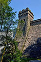
Old chimney in Danebower Quarries


Summit cairn on Seat (Buttermere)

Herdies (Herdwick Sheep) in front of Green Crag (Buttermere)

Green Crag (Buttermere) summit cairn with Kirk Fell beyond

Buttermere and Crummock Water from Green Crag (Buttermere) summit

View from the approach to Ponsonby Fell through Blengdale Forest

The Wasdale Screes below Illgill Head (centre) and Whin Rigg (right) from Ponsonby Fell


View from the summit of Ponsonby Fell

Ponsonby Fell summit cairn almost hidden in long grass


The Ennerdale Fells from the summit of Ponsonby Fell

Grange-over-Sands and Morecambe Bay from Arnside Knott

Kent Viaduct (railway bridge) across Morecambe Bay from Arnside Knott

Handgate on Arnside Knott with Kent Viaduct (railway bridge) across Morecambe Bay in the distance

Signed path junction on Arnside Knott

Arnside Knott summit trig point

Looking South across Morecambe Bay towards Morecambe itself from Arnside Knott

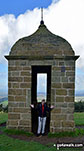
Memorial overlooking Cove Harbour

The view from the top of Stob Binnein

Stob Binnein (The Anvil Peak) from Ben More (The Crianlarich Hills)
Castle Crag in the 'Jaws' of Borrowdale taken from the north end of Derwent Water
The Skiddaw massif along with Walla Crag (to the right) from the southern end of Derwent Water


Hallin Fell from a viewpoint on the descent from High Dodd (Sleet Fell)

Red Screes from St Raven's Edge

The summit cairn on St Raven's Edge


The welcoming party on the summit of Killhope Law

Made it! Me on the summit of my Killhope Law, final English Nuttall

Me on the summit trig point of Killhope Law, my final English Nuttall

The bog surrounding the trig point of Killhope Law

What's left of the 40ft pole on the summit of Killhope Law

Finally the sun came out as we descended Killhope Law


Tryfan (left), Glyder Fawr, Y Garn (Glyderau) (right) and Llyn Ogwen from near Glan Dena

Looking towards Whins Brow, Langden Brook and Dunsop Bridge from Hareden Fell

Looking towards Kinder Scout from Mam Tor

Falcom Clints and The Rever Tees from near White Well Green on Moor House (Cronkley Fell)


The grassy path up Watch Hill (Cockermouth)

Small pile of stones which seem to mark the highest point on Watch Hill (Cockermouth)

Setmurthy Common (Watch Hill) summit

The summit of Setmurthy Common (Watch Hill)


The Skiddaw Massif from the path up Clints Crags

Cows blocking my way up Clints Crags


The Limestone escarpment on Clints Crags

The tiny cairn on the top of Clints Crags

The Lorton Fells from Clints Crags Summit

Thackray Cottage below Clints Crags escarpment


Looking back to Yoadcastle from the summit of The Knott (Stainton Fell)

The view from the path up Buck Barrow


Looking towards Kinmont Buck Barrow summit from Buck Barrow

Kinmont Buck Barrow summit cairn

The Knott (Stainton Fell) summit trig point


Whitfell (Whit Fell) summit trig point

Holehouse Tarn near Stainton Fell

Whitfell (Whit Fell) summit cairn and shelter

Whitfell (Whit Fell) summit appears out of the mist

A good path up Swindale Edge with Roman Fell on the right

A Military Bunker on Tinside Rigg

An interesting marker on the way to Long Fell


Cow Green Reservoir from Viewing Hill summit


Roman Fell summit cairn and shelter


The summit cairn on Viewing Hill


Looking down to Nenthead from The Dodd


Bink Moss summit complete with Wellies


The small summit cairn on Bullman Hills

The small cairn at the north-east end of the Bullman Hills ridge

The view from Bullman Hills looking north-east towards Garrigill

Cairn on the summit of Long Man Hill


The remains of a Hill Fort in the Lammermuir Hills

Approaching the top of Meldon Hill (Dufton Fell)

Natural Arch near Cockburnspath

The stone built Trig Point on the summit of Backstone Edge (Dufton)

Backstone Edge (Dufton) summit cairn now minus its pole


The tall marker cairn on the summit of Bellbeaver Rigg (Tynehead Fell)

Bellbeaver Rigg (Tynehead Fell) summit cairn

Round Hill (Tyne Head) from the descent off Bellbeaver Rigg (Tynehead Fell)

Round Hill (Tyne Head) summit cairn

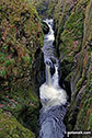
Waterfalls on Tyne Head near the source of The River Tyne

The Ingleton Waterfalls Trail Notice Board

The River Twiss on The Ingleton Waterfalls Trail

The River Twiss on The Ingleton Waterfalls Trail

The Money Tree on The Ingleton Waterfalls Trail
Peca Falls on The Ingleton Waterfalls Trail

Lower Peca Falls on The Ingleton Waterfalls Trail

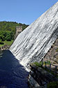
Thornton Force on The Ingleton Waterfalls Trail

An Old Gnarled Tree on The Ingleton Waterfalls Trail

Ingleborough from Beezley Falls at the upper end of The Ingleton Waterfalls Trail

Triple Spout Falls on The Ingleton Waterfalls Trail
Baxenghyll Gorge on The Ingleton Waterfalls Trail


Coate Moor above a cloud inversion near Roseberry Topping

Shooting Box near Roseberry Topping

Stunted Pine south west of Roseberry Topping (top right)

Approaching Roseberry Topping from the south west

On the summit of Roseberry Topping

Roseberry Topping from Roseberry Common

Roseberry Topping from near Captain Cook's Monument on Easby Moor

RAF Memorial Plaque near Captain Cook's Monument on Easby Moor

Roseberry Topping from the Cleveland Way near Captain Cook's Monument on Easby Moor
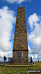
Captain Cook's Monument on Easby Moor


Looking up to a snowy Great Gable from Sty Head

Sty Head Tarn with Base Brown beyond in the snow

Checking the GPS on Sty Head in the snow


The Stretcher Box at Sty Head in the snow

Snow on Great Napes from Sty Head


Snow on Great Napes from Sty Head

Burnthwaite Farm Kitchen, Wasdale Head

Burnthwaite Farm Bedroom, Wasdale Head

Burnthwaite Farm Lounge, Wasdale Head

Burnthwaite Farm Bedroom Two, Wasdale Head

Great Gable from Burnthwaite Farm, Wasdale Head

Dore Head (left) and Pillar from Mosedale, Wasdale Head


Bassenthwaite Lake from Hursthole Point

Woodend Brow, Bassenthwaite Lake

National Trust plaque at the bottom of Jacob's Ladder

The bridge over the River Noe at the bottom of Jacob's Ladder


Lost on a misty Kinder Scout in the Great Grimpen Mire

Into the abyss on a misty Kinder Scout

Sculptured rocks on a misty Kinder Scout

Sculptured rock streams on a misty Kinder Scout

Cascading water on a misty Kinder Scout

Caldron on a misty Kinder Scout

Caldron on a misty Kinder Scout

Its getting a bit wet and windy on a misty Kinder Scout

More rock formations on a misty Kinder Scout

Descending back to Edale from a misty Kinder Scout

Paignton Harbour from the South West Coast Path (SWC)

On the South West Coast Path (SWC) near Inner Forward Point

Scabbacombe Sands on the South West Coast Path (SWC)

Renwick Fell (Thack Moor) lit by the setting sun from Grey Nag

Renwick Fell (Thack Moor) summit Trig Point under a light dusting of snow

Sun and snow on Skiddaw and Blencathra from Black Fell (Haresceugh Fell)


The Packhorse Bridge over The River Derwent at the northern end of Howden Reservoir

Howden Edge and the Crow Stones from Bull Clough at the northern end of Howden Reservoir

Island Plantation in the middle of Derwent Reservoir
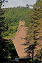
Water cascading over Howden Reservoir Dam


The River Lathkill in Lathkill Dale

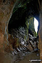
The view from a cave in Lathkill Dale

Waterfalls on the River Lathkill in Lathkill Dale

Inside one of the Lathkill Dale Mines

Shaft down one of the Lathkill Dale Mines

Access ladder into one of the Lathkill Dale Mines


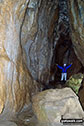
Lathkill Head Cave, Lathkill Dale

Troglodytes in Lathkill Head Cave, Lathkill Dale


The River Lathkill in Lathkill Dale


Walkers and Cyclists near the Kings Tree turning circle at the northern end of Howden Reservoir


Yachts on Dove Stone Reservoir with Alderman's Brow in the background

Barges at Adlington Basin on the Macclesfield Canal

Upper Scaur Valley from the Southern Upland Way near Collar Knowe (Cloud Hill)

Me beside Loadpot Hill summit cairn

The ridge path between Wether Hill and Loadpot Hill

The River Manifold below Thor's Cave


The Manifold Valley from Thor's Cave

Inside another cave above Thor's Cave

Inside another cave above Thor's Cave


The old bridge below Wettonmill

The River Manifold below the old bridge below Wettonmill

Thor's Tor and Thor's Cave in The Manifold-Valley

Black Fell (Haresceugh Fell) summit Trig Point

Cold Fell Pike (Geltsdale) Summit living up to its name under a light dusting of snow

Curricks on Tindale Fell under a light dusting of snow

Grey Nag Summit cairn and Trig Point


The summit of Knott (Uldale Fells)


The cairn on the summit of Glaramara


Me on the summit of Gray Crag (Hayeswater)

On the summit of Nethermost Pike


Sitting on Dove Crag summit cairn in the snow


Harter Fell (Eskdale) summit Trig Point

The Scafell Massif from the summit of Haycock


The Trig Point on the summit of The Old Man of Coniston

Cairn on the summit of Rossett Pike

Grey Crag (Sleddale) summit cairn

The tall cairn on the summit of Dale Head (Newlands)


The large cairn on the High Raise (Mardale) summit)

Branstree (Artlecrag Pike) summit beacon

On the summit of Mungrisdale Common


The view from the summit of Lord's Seat (Whinlatter)

The cairn on the summit of Great Sca Fell

The view from the summit of Pavey Ark


Me on the summit of Sergeant Man

On the summit of Helvellyn in the snow


The cairn and tangle of old fence posts that mark the summit of Little Dodd (Ennerdale)

Pike of Stickle (Pike O' Stickle) summit cairn


The cairn on the summit of Grike


The Trig point on the summit of High Raise (Langdale)

Long Side summit cairn with Skiddaw beyond


Harrison Stickle summit cairn complete with post

The summit of Ard Crags with the shoulder of Robinson and High Snockrigg beyond

The summit cairn on Brock Crags

Me by the large cairn on the summit of Glenridding Dodd with Ullswater in the background

Me beside the Trig Point on High Raise (Langdale) Summit


Bannerdale Crags summit cairn with Blencathra beyond


The cairn on the summit of High Rigg

The tall beacon on the summit of The Old Man of Coniston


The summit cairn on Fairfield with Windermere in the distance

The summit cairn on Hartsop Dodd


The summit cairn on Knott Rigg

Me on Harter Fell (Mardale) summit cairn


High Hartsop Dodd summit cairn in the snow

The summit cairn on Dollywaggon Pike

The cairn and bench on the summit of High Pike (Caldbeck)

Me by the Trig Point on the summit of Pillar

The cairn and fence on the summit of Burnbank Fell

Catstye Cam and Ullswater from Helvellyn

The cairn and plane crash memorial on the summit of Great Carrs

The large beacon on the summit of High Spy

The flat cairn on the summit of Birks


The Ordnance Survey Concrete Ring on the summit of Branstree (Artlecrag Pike)

Gowbarrow Fell summit Trig Point

The Trig Point on the summit of Helvellyn


Scar Crags (left), Sail and Crag Hill (Eel Crag) from the summit cairn on Outerside


Little Mell Fell summit Trig Point

The summit cairn on Fleetwith Pike

Little Scoat Fell from the summit of Steeple

The small cairn on the summit of The Nab (Martindale)
The lovely skies over Pendle Hill (Beacon or Big End)
To contribute to go4awalk.com or to contact us about anything at all - see Talk To Us.
For help see Help.
go4awalk.com and go4awalk.co.uk are registered trademarks of TMDH Limited.
Copyright © 2000-2026 TMDH Limited. All rights reserved.
Copyright Terms & Conditions Privacy Statement
A - Z Walks Home Log On/Accounts Photo Gallery Walk Ideas and Collections Fell Facts Hill Skills Walking Questions and Answers Your Stories News Competitions Product Reviews/Gear Tests Walking Gear Guides Peaks and Mountains Peak Bagging Find New Walking Friends Camping GPS Waypoints for Walking Contents Walk Search Talk To Us go4awalk.com Help Free Example Walks Newsletter


