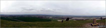
Walk Photographs and views from British Walks published during 2013

Steps up through woodland towards Birchen Edge

Path through woodland below Birchen Edge

Approaching Nelson's Monument (Birchen Edge)

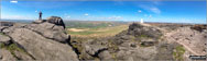
Birchen Edge near Nelson's Monument (Birchen Edge)

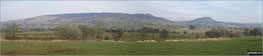
Looking along Birchen Edge from Nelson's Monument (Birchen Edge)

Nelson's Monument (Birchen Edge)


Victory - the first of three huge boulders that form The Three Ships on Birchen Edge

Defiance - the middle of three huge boulders that form The Three Ships on Birchen Edge

Royal Soverin - the third of three huge boulders that form The Three Ships on Birchen Edge

Nelson's Monument (Birchen Edge) from The Three Ships on Birchen Edge

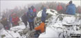
Busy day with plenty of climbers on Birchen Edge

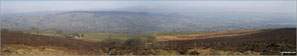
Looking down from Birchen Edge

Looking north to Nelson's Monument (Birchen Edge)

Birchen Edge summit trig point

Cottages by the path into Chatsworth Park from Baslow

The Cannon Kissing Gate allowing access into Chatsworth Park from Baslow


Close-up view of Jubilee Rock, Chatsworth Park

Path from Chatsworth Park into Jumble Coppice

Rock cliffs above Jumble Coppice

Rock cliffs above Jumble Coppice

Footbridge across Heathy Lea Brook in Jumble Coppice - near The Robin Hood

White Edge (Big Moor) (South East Top) summit trig point

The trig point on the summit of White Edge (Big Moor) (South East Top)

The path along the top of White Edge (Big Moor)

Shelter/ruin on the summit of White Edge (Big Moor)


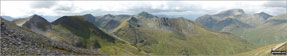
Na Gruagaichean from Binnein Mor in the Eastern Mamores

Na Gruagaichean (North West Top) from Binnein Mor in the Eastern Mamores


Ben Nevis and Carn Mor Dear from Binnein Mor in the Eastern Mamores

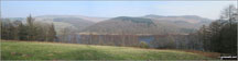
The Cheshire Countryside near Three Shires Head


Looking SW across the Dane Valley from near Three Shires Head

Shutlinsloe from Tagsclough Hill

The stream in Wildboarclough in spate


Sunlight falling through the entrance to Blore Church

Hurkling Stones and Whinstone Lee Tor beyond Ladybower Reservoir

Back Tor (Derwent Edge) beyond Ladybower Reservoir

Access Road to Crookhill Farm, Ladybower Reservoir


Barn near Crookhill Farm on the lower slopes of Crook Hill (Ladybower)


Crook Hill (Ladybower) from Crookhill Farm

Crook Hill (Ladybower) from Crook Hill (Ladybower) (South Top)

Ladybower Reservoir and the lower slopes of Win Hill from Crook Hill (Ladybower)

Crook Hill (Ladybower) from Crook Hill (Ladybower) (South Top)

Crook Hill (Ladybower) (South Top) summit


Crook Hill (Ladybower) (South Top) from Crook Hill (Ladybower)

On the craggy summit of Crook Hill (Ladybower)


Crook Hill (Ladybower) and Crook Hill (Ladybower) (South Top) from Bridge-end Pasture


Pike Low above Ladybower Reservoir from Hagg Side Woods

Ladybower Reservoir from Hagg Side Woods


Pipe/Foot Bridge across and inlet, Ladybower Reservoir

Surf riders; looking towards Tyninghame from near Dunbar


Early morning looking west from road to Mungrisdale


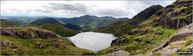
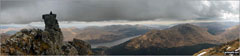
Thirlmere Reservoir from path from near Browncove Crags

Dove Stone Reservoir overflow with Great Dove Stone Rocks in the background

Dovestone Reservoir and Great Dove Stone Rocks from Chew Brook

Dovestone Reservoir with Dick Hill in the background from near Chew Brook

On the Oldham Way climbing towards Stable Stones Brow (Hoarstone Edge)


Looking back to Chew Brook and Chew Reservoir from the Stable Stones Brow (Hoarstone Edge) ridge

Dovestone Reservoir appearing through the mist from Stable Stones Brow (Hoarstone Edge)

Dovestone Reservoir and Dick Hill from Stable Stones Brow (Hoarstone Edge)

Alphin Pike from Stable Stones Brow (Hoarstone Edge)

On Stable Stones Brow (Hoarstone Edge)

Alphin Pike from Stable Stones Brow (Hoarstone Edge)

The top of Chew Brook and Chew Reservoir from the Stable Stones Brow (Hoarstone Edge)

On Stable Stones Brow (Hoarstone Edge)

Dick Hill above Dovestone Reservoir from Stable Stones Brow (Hoarstone Edge)

Alphin Pike from Stable Stones Brow (Hoarstone Edge)

Stable Stones Brow (Hoarstone Edge) from near Alphin Pike

Dick Hill and Dovestone Reservoir from near Alphin Pike

Dick Hill and Great Dove Stone Rocks above Dovestone Reservoir from Alphin Pike


Alphin Pike summit cairn and trig point

Arthur's Seat from Edinburgh Castle

St. Bartholomew's Church, Blore

The nave inside St. Bartholomew's Church, Blore

The Bassett Monument inside St. Bartholomew's Church, Blore

The Bassett Monument inside St. Bartholomew's Church, Blore

Ancient gravestone inside St. Bartholomew's Church, Blore

The Plaque beneath the Bassett Monument inside St. Bartholomew's Church, Blore

The Bassett Monument inside St. Bartholomew's Church, Blore

Display case containing medieval tiles inside St. Bartholomew's Church, Blore

The Bassett Monument inside St. Bartholomew's Church, Blore

Looking towards the The Bassett Monument inside St. Bartholomew's Church, Blore

The Apse, St. Bartholomew's Church, Blore

A black and white shot of Red Deer just below the summit of Glas Charn (Aberchalder Forest)


Ullswater from Keldas near Lanty's Tarn

Looking south towards Skipton and Airedale from Crookrise Crag Top

On the summit trig point on Crookrise Crag Top

Crowden Brook with Bareholmes Moss beyond from Crowden

The spoil heaps above Brookholes Wood, Crowden


Bareholme Moss and Crowden (right) from Oakenclough Brook

Approaching Black Chew Head (Laddow Rocks) (left) and Laddow Rocks

Black Chew Head (Laddow Rocks) summit cairn and pole

The Pennine Way on Black Chew Head (Laddow Rocks)

The Pennine Way on Black Chew Head (Laddow Rocks) with Black Hill (Soldier's Lump) in the distance

Looking back along The Pennine Way to Black Chew Head (Laddow Rocks)


The Crowden valley from The Pennine Way on Black Chew Head (Laddow Rocks)

The Pennine Way north of Black Chew Head (Laddow Rocks)

Crowden Great Brook on Sliddens

Crowden Great Brook in the sunshine at Near Broadslate

Crowden Great Brook near Sliddens

The Pennine Way across Dun Hill

Looking back to Black Chew Head (Laddow Rocks) from The Pennine Way on Dun Hill

The Pennine Way on Black Hill (Soldier's Lump) about 150m from the summit

Black Hill (Soldier's Lump) summit trig point

Waymarker cairn on Tooleyshaw Moss

Waymarker cairn on Tooleyshaw Moss

Waymarker cairn on Tooleyshaw Moss marking the entrance to a section of peat groughs


Fence stile on Tooleyshaw Moor

Summit post on a wet and boggy Westend Moss

Hay Moss and The Crowden Valley from Westend Moss

Descending towards Crowden from Westend Moss

The Crowden Little Brook from Hey Moss above Crowden

Torside Reservoir and Rhodeswood Reservoir from Hey Moss above Crowden

Crowden and Torside Reservoir from Hey Edge

Not your usual walkers on The Bridgewater Canal

Yockenthwaite Moor summit Trig Point

Towers and Curricks on Fountains Fell


Darnbrook Fell summit Trig Point


View from High Cap on the way up Cross Fell


Little Dun Fell and Great Dun Fell from Cross Fell


Little Dun Fell summit shelter

Approaching the summit of Great Dun Fell summit


Park Fell (Ribblehead) summit in mist


The Pennine Way from High Cup down to Dufton

Loughrigg Fell and Rydal Water from Nab Scar

Helm Crag, Gibson Knott and Steel Fell from Nab Scar

Looking down to Alcock Tarn from near Heron Pike with Helm Crag, Gibson Knott and Steel Fell beyond

Rydal Head with Fairfield (left) and Hart Crag (right) from Great Rigg

Fairfield summit cairn with Windermere in the distance

The Central Fells and Seat Sandal (right) from the summit of Fairfield

Fellow go4awalkers Chris and Alan on Fairfield summit


The view towards Patterdale from Hart Crag

Windermere from Low Pike (Scandale) on the way back down from completing The Fairfield Horseshoe


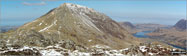
Y Lliwedd Bach (centre), Y Lliwedd (East Top) and Y Lliwedd (far right) from the north east ridge

Nantgwynant with Ysgafell Wen and Cnicht on the horizon from the summit of Y Lliwedd


Llyn Llydaw from a gap in the crags near Bwlch y Saethau on the upper slopes of Snowdon (Yr Wyddfa)


On the summit of Snowdon (Yr Wyddfa) with Y Lliwedd in the background

Walking through woodland on the banks of Langsett Reservoir


Walking through woodland on the banks of Langsett Reservoir


Walking through woodland on the banks of Langsett Reservoir

The Porter or Little Don River from Langsett Reservoir

Mickleden Edge from The Porter or Little Don River


Walking through woodland on the banks of Langsett Reservoir

Walking through woodland on the banks of Langsett Reservoir


Walking through woodland on the banks of Langsett Reservoir


The Porter or Little Don River


Walking through woodland on the banks of Langsett Reservoir

Walking through woodland on the banks of Langsett Reservoir

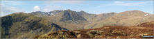
The view up the Alport Valley from Crookstone Knoll on the northern edge of the Kinder Plateau

On the summit of Carnedd Moel Siabod in the January snow


Field of wild flowers after Kinder Scout, towards Edale

Moray Hillwalkers on the PYG Track up Mt Snowdon


My husband on The Watkin Path up Snowdon

Julie Senior enjoying the view from Stac Pollaidh


Jemima, Jack & Dougie exploring the Rossendale Valley

Chris near Twll Du (Devil's Kitchen)

Chris near the top of Ben Nevis


My friend Annabelle at the summit of Coniston Old Man


Carnedd Moel Siabod (left, distance) and Llyn Llydaw from the top of Crib Goch

Clare on the summit of Garnedd Ugain (Crib y Ddysgl)

Clare on the summit of Garnedd Ugain (Crib y Ddysgl) with Crib Goch in the background (bottom right)

Snowdon (Yr Wyddfa) from the summit of Garnedd Ugain (Crib y Ddysgl)

My son Ben Collier (12) on top of Blackstone Edge

Blackstone Edge summit trig point
My son Ben Collier (12) on top of Blackstone Edge


4th Sevenoaks Scouts Cycle Expedition at The Long Man of Wilmington

Jerusalem Baptist Church hike on Pant y Creigiau with Talybont Reservoir in the background

Sarah, Me, Jenny & Amy at Hollins Cross stretching our hamstrings!

Me on top of Place Fell with Ullswater in the background


My husband and children at Stickle Tarn, Great Langdale


The Caldey Island/Ynys Byr coast

A family walk around Blackmoorfoot Reservoir near Huddersfield on a sunny afternoon


The view from Ditchling Beacon


Topdog hikers on Wild Boar Fell

A gentle walk on the shore of Rudyard Reservoir for little legs

My son Joe jumping for joy between Adam and Eve on the top of Tyfan

Mark and Joe tackling Crib Goch

My son in law Mark waking up on the top of Snowdon with fabulous clouds down below

Mick and Rob, friends of 40 years make it to the top of a windswept Pen Y Fan

Don't look down - Llanberis Slate Mines

Tony and myself (on the right) on the top of Harrison Stickle

On top of The Cobbler (Ben Arthur)

Loch Long from The Cobbler (Ben Arthur)

The Brack from The Cobbler (Ben Arthur)
The Cobbler (Ben Arthur) (left), Loch Long and The Brack (right)


My son Daniel and our 2 dogs Brecon and Maggie at the top of The Skirrid

Godrevy Island from Carbis Bay

Me at the top of Pen Y Fan on a wonderful 'brooding' day


Justin at Pen-y-Ghent summit trig point


The Carrauntoohill Horseshoe from Lough Eighter MacGillycuddy�s Reeks County Kerry,

The magnificent view from The Calf in the Howgills after a full English and a stiff climb

A great day on Carnedd Moel Siabod


Looking towards Malvern from Brown Clee Hill

Looking towards Bridgenorth from Brown Clee Hill at sunset


Jesper Jorgensen on the Cuillin Ridge Isle of Skye

David Ward on Sgurr Dearg (Inaccessible Pinnacle a.k.a. 'In Pin')

Stickle Tarn from half-way up Jake's Rake, Pavey Ark

Me and my lad on the 'cantilever stone' on Glyder Fach

Angle Tarn (Martindale) frozen in the snow

Angle Tarn (Martindale)in the snow

View today of The Wrekin from The Brown Clee Hill (Abdon Burf)

My partner Anthony and our lovely dog Cookie on top of Loughrigg Fell on a blustery Sunday

Murton Fell from the Narrow Gate Path on the west side of High Cup

Approaching High Cup Gill above High Cup Nick, High Cup with Murton Fell beyond


At High Cup Gill above High Cup Nick, High Cup

Birkhouse Moor (foreground) and Striding Edge (right background) from Sheffield Pike


White Side and Raise (Helvellyn) from Sheffield Pike

Corn Du and the Brecon Beacons from the summit of Pen y Fan just after sunset

Pitstone Windmill from Ivinghoe Beacon
Corn Du and the Brecon Beacons from the summit of Pen y Fan just after sunset


Ivinghoe Beacon summit trig point

The view from the summit of Ivinghoe Beacon


Ian and Baillie Wright on the East side of Worcestershire Beacon

Heading up to Stanage Edge last week

Family group having completed Striding Edge before the last pull up to Helvellyn.

Me and mate Mike on Scafell Pike

Me and my mate Mike on Whernside

Me and my mate Mike on Ben Nevis

My wife Pat halfway up Scafell Pike

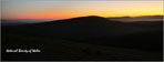
Wintery walk at the top of Hay Bluff in the snow


On top of Causey Pike with Scar Crags, Sail (Derwent Fells) and Crag Hill (Eel Crag) behind


Snow and ice at Aber Falls (Rhaeadr-fawr)


It was a bit draughty on our walk from Osmotherley to Clay Bank Top

Lunch on Hen Cloud the Roaches

Looking back over Tittesworth Reservoir from Hen Cloud the Roaches

R&R's Walking Group on the way up The Roaches

My son on Merbach Hill looking over to Hay Bluff and Twmpa (Lord Hereford's Knob)

My husband, Graham, on the South West Coast Path overlooking Bat's Head in the Purbecks

My son at Merbach Hill trig point with Hergest Ridge, Colva Hill and Glascwm Hill in the distance

Me, Wainwright bagging, at the top of Middle Dodd with Brothers Water and Place Fell in the distance


A sprinkling of snow on Tryfan (left) and Glyder Fach (right) above Llyn Ogwen from Pen yr Ole Wen

Iain, Tim and I finishing the mammoth 80 odd mile Dales Way walk at Windermere on the finishing seat

Llyn Ogwen and the Ogwen Valley from the lower slopes of Cefn Ysgolion Duon


Me and a friends little girl attempting a wee picnic up Haresfield Beacon

At Nelson's Monument (Birchen Edge)

Hen Cloud and The Roaches from near the Mermaid Pub


Cribyn from Pen y Fan in the snow

Fred on the top of Arthur's Seat

My 2 daughters, husband and not forgetting the 13 year old dog

Stepping Stones in Chee Dale, The River Wye


Snow on Scafell Pike from a frozen Innominate Tarn
Snow on Scafell Pike and the Scafell Massif from a very frozen Innominate Tarn

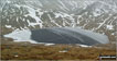
Seat (Buttermere), Gamlin End and High Crag (Buttermere) from Hay Stacks (Haystacks)


A frozen Grisedale Tarn from the lower slopes of Dollywaggon Pike in the snow
A frozen Grisedale Tarn from the lower slopes of Dollywaggon Pike in the snow

On Blackstone Edge near Rochdale on Easter Saturday 2013


On the summit of Snowdon (Yr Wyddfa) with Crib Goch (left) and Llyn Llydaw (right) in the background

On the summit of Snowdon (Yr Wyddfa)


Fleetwith Pike refelected in Buttermere

Fleetwith Pike across Buttermere


Robinson and Buttermere from Old Burtness below Red Pike (Buttermere)

Red Pike (Buttermere) (left) and Dodd (Buttermere) right from Old Burtness below Bleaberry Tarn

Russ with High Snockrigg, Robinson and Buttermere in the background from above from Burtness Wood

Russ and Me on the summit of Red Pike (Buttermere) in the snow

Me and Russ at the top of Scale Force

The Grasmoor Fells from near Bleaberry Tarn


Buttermere (below), Whitless Pike (left) and High Snockrigg (right) from Ling Comb


A lone sheep blocks the track above Renwick

Quiet track above Townend, Renwick

Renwick Fell (Thack Moor) summit trig point

Renwick Fell (Thack Moor) from Watch Hill (Graystone Edge)


Black Fell (Haresceugh Fell) summit


Waypoint marker for the c2c (coast to coast) cycle route near Hartside Top Cafe

Footpath to Selah Bridge (& Renwick) from near Hartside Top Cafe

Me on the left, looking towards Ullswater & St Sunday Crag (right) from a very snowy Seat Sandal

On the summit of Dodd (Skiddaw) on Easter Monday, 2013

Myself about to tackle Sharp Edge (Blencathra)

Ann on the top of Titterstone Clee Hill

My mate Rich just strolling past the 'Bad Step' on Sharp Edge without really noticing it!


Me on top of Arthur's Seat in Edimburgh


A very poor view from the top of An Sgurr (Eigg) on the Isle of Eigg

A snowy mothers day on Kinder Scout

The view from Mount Snowdon with a touch of hoar frost on the grass making them into white ribbons


Relaxing with a great bunch of friends in Glen Nevis after returning from the waterfall


Hen Cloud from the lane north of Meerbrook
The Roaches and Hen Cloud from the lane north of Meerbrook

Woodland path near Meadows Farm

Gun (Staffordshire) from near Meadows Farm


The Roaches from Turner's Pool

Gun (Staffordshire) summit trig point
The Roaches and Hen Cloud from the summit of Gun (Staffordshire)

The Staffordshire countryside from near Gun (Staffordshire)

The Staffordshire countryside from near Gun (Staffordshire)

The Abbey Inn in Abbey Green near Leek

The Staffordshire countryside near Abbey Wood


The Roaches and Hen Cloud from the summit of Hillswood

The Roaches and Hen Cloud from Tittesworth Reservoir


A 70th birthday on the top of Tryfan

On the summit of Winhill Pike (Win Hill) in the snow

One man and his dog, a gorgeous day walking from Mam Tor to Hollins Cross

Deep snow near Queensbury on Friday 22nd March 2013

Me on top of Goatfell (Goat Fell) on The Isle of Arran

On the Dales Way near Kettlewell

Biscuits and hot chocolate near Llyn Idwal with the Nant Ffrancon valley in the distance


Myself and Steve Taylor on the top of Fairfield in thick mist

The Pen Y Fan ridge from Lower Neuadd Reservoir


Derwent Water from Cat Bells (Catbells)

St Oswald's Bay - known locally as Man O'War Bay

Rannoch Moor from The pass of Glen Coe

Grisedale Tarn in the snow with St Sunday Crag (centre left) and Fairfield (right)

Pantmaenog Forest Slate Mine from Rosebush

The Preseli Hills from Rosebush in the snow

Lake Coniston & Coniston Village from The Old Man of Coniston

Thirlmere and a snowy Helvellyn range from Raven Crag (Thirlmere)

Nap-of-earth fighter plane training seen from Aonach Mor


My dog and hubby after a steep cliff climb near Tintagel

The view from the top of a hill in Boscastle

My sister on the Miners' Track up Snowdon with Glaslyn in the background

The Sgurr Choinnich Mor Ridge in May

The view from Colley Hill in winter

The view from Brown Clee Hill (Abdon Burf)

At the summit of Snowdon in March 2012


My wife, two children, aunt and uncle on top of a large hill overlooking Solva Harbour

My son and Daughter on a hill overlooking the Pembrokeshire Coastline near Solva Harbour


Muckle Flugga from Herma Ness, Unst

Y Lliwedd summit from Y Lliwedd (East Top) with Snowdon (Yr Wyddfa) in the distance

My wife on the summit of Golden Cap

Loch Lomond from near Conic Hill

The Forth Road Bridge at night

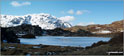
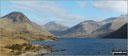
Yewbarrow (left), Great Gable and Lingmell (right) from Wast Water
Yewbarrow (left), Great Gable and Lingmell (right) and Scafell Pike (far right) from Wast Water


Grasmoor from Crag Hill (Eel Crag) trig point


Hopegill Head and Sand Hill from Crag Hill (Eel Crag) trig point

The top of Hobcarton Crag and Grisdale Pike from Crag Hill (Eel Crag) trig point

The top of Hobcarton Crag and Grisdale Pike from Crag Hill (Eel Crag) trig point


The snow covered Southern Fells from Crag Hill (Eel Crag) trig point

The Western Fells from Crag Hill (Eel Crag) trig point


The view inside Victoria Cave, Attermire Scar near Settle on Christmas Day!

Fantastic double rainbow seen from Countisbury Hill above Lynmouth

The South West Coast Path between Tintagel and Port Issac

The Three Amigos on top of Simon's Seat
Northern Souls Walking Club at the Remembrance Day service on top of Great Gable

My lovely husband Dean at The Big Pit in Blaenavon


Brunt Knott and Sharp Edge with Atkinson Pike above from Scales Beck

Path through Lever Park from Rivington Lane Car Park

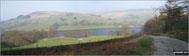
The Castle (Lower Rivington Reservoir)

The Castle (Lower Rivington Reservoir)

Lower Rivington Reservoir shore path


Woodland path above Rivington Hall

Woodland path above Rivington Cottage

Woodland path above Rivington Upper Barn


Pigeon Tower (Rivington Moor) with Rivington Reservoir in the distance

Great Hill and Spitlers Edge from Winter Hill (Rivington Moor)

Snow on Winter Hill (Rivington Moor)

Winter Hill (Rivington Moor) summit trig point

Telecommunications tower on Winter Hill (Rivington Moor)

Warning sign on Winter Hill (Rivington Moor)

Memorial on Winter Hill (Rivington Moor)
The tall TV mast on the summit of Winter Hill (Rivington Moor)

Lower Rivington Reservoir from Rivington Pike

The three cairns on the summit of Two Lads (Rivington Moor)

Winter Hill (Rivington Moor) from Rivington Pike


Winter Hill (Rivington Moor) from Two Lads (Rivington Moor)

Millenium Cairn near Muker, Swaledale

My brother Peter knee deep in snow on tap o' the Bin of Cullen


Hollow Moor (Green Quarter) summit

Water disappearing in Ease Gill


Windermere from the summit of Orrest Head

The Kentmere Fells from Hollow Moor (Green Quarter)

Skeggles Water on the way to Hollow Moor (Green Quarter)

View from Scout Scar (Barrowfield)

Scout Scar (Barrowfield) summit

Morcombe Bay from Scout Scar (Barrowfield)


Looking across Loch Shieldaig and Upper Loch Torridon from above our holiday cottage near Kenmore

Horton in Ribblesdale church with Pen-y-ghent in the distance

Ingleborough from above Brackenbottom

Pen-y-ghent from Brackenbottom Scar

Pen-y-ghent from The Pennine Way on Gavel Rigg

Fountains Fell from Pen-y-ghent

The Pennine Way crossing Gavel Rigg from Pen-y-ghent


Pen-y-ghent summit wind shelters in a little bit of snow

Pen-y-ghent summit trig point with a little bit of snow

Plover Hill from the large cairn NW of Pen-y-ghent summit

Pen-y-ghent Side Scar in the snow

Looking back up to Pen-y-ghent from Pen-y-ghent Side Scar in the snow

Pen-y-ghent from The Pennine Way above Hunt Pot

Pen-y-ghent from The Pennine Way near Hull Pot

Sell Gill Beck on Whitber Hill

Simon Fell and Ingleborough from Whitber Hill

God's Bridge over Brow Gill Beck

Brow Gill Beck from God's Bridge

Footbridge over Ling Gill Beck at Nether Lodge


The Carn Mor Dearg Arête from near Carn Mor Dearg

Graham walking near Thorncombe Hill

Cold Fell Pike (Geltsdale) summit on the snow

From the top of Great Orme, Llandudno

Clough Head, Calfhow Pike, Great Dodd and Watson's Dodd from Castlerigg in the snow

Castlerigg Stone Circle in the snow


Our dog Ted enjoying the view in the way up Helvellyn

On Meall nan Tarmachan in the snow

Nick and Jet my dog at the top of Schiehallion


Loch Leven and Glenco from near the summit of Bidean Nam Bian


My son Harry on the top of Earl's Hill near Pontesbury


Dawn taking in the view from Corn Du

Me, halfway across Sharp Edge, trying to be brave

Walking up to Gibbett Hill with family and dogs


Myself and husband Stuart at Garn Fawr

My mountain dog Degla, admiring the view (near the top of the PYG/Miners' Track) off Mount Snowdon

Lovely days climbing at Trevor Rocks in Llangollen with the Clywdian range in the background


My Husband Matt above Loch Morar

A snow capped Tor Y Foel from Talybont Reservoir Dam

Sunset from Eston Nab in the Eston Hills
To contribute to go4awalk.com or to contact us about anything at all - see Talk To Us.
For help see Help.
go4awalk.com and go4awalk.co.uk are registered trademarks of TMDH Limited.
Copyright © 2000-2026 TMDH Limited. All rights reserved.
Copyright Terms & Conditions Privacy Statement
A - Z Walks Home Log On/Accounts Photo Gallery Walk Ideas and Collections Fell Facts Hill Skills Walking Questions and Answers Your Stories News Competitions Product Reviews/Gear Tests Walking Gear Guides Peaks and Mountains Peak Bagging Find New Walking Friends Camping GPS Waypoints for Walking Contents Walk Search Talk To Us go4awalk.com Help Free Example Walks Newsletter


