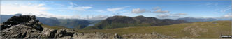
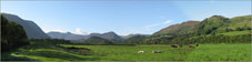
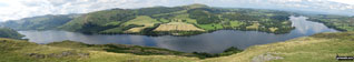
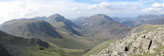
Photographs and Pictures taken from local, easy-to-follow, circular walks by Chris Brankin

To find a walk route* to the locations featured in these pictures, click the thumbnail. The most recent pictures are at the top.
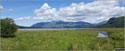
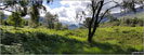
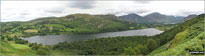
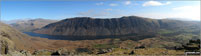

Derwent Water and Borrowdale with Cat Bells, Maiden Moor and Castle Crag on the right from the northern end of the lake   The Skiddaw massif along with Walla Crag (to the right) from the southern end of Derwent Water   Castle Crag in the 'Jaws' of Borrowdale taken from the north end of Derwent Water   Loweswater photographed from the terrace path above Holme Wood   Mellbreak taken in the evening sunlight from the Kirkstile Inn in Loweswater Village   Whin Rigg (left) and Lund Bridge from Buckbarrow   Illgill Head (left) and Whin Rigg (right) above the Wast Water screes from Buckbarrow   The Scafel Massive featuring Ling Mell, Great End, Broad Crag, Ill Crag, Scafell Pike, Symonds Knott and Sca Fell above Wast Water from Buckbarrow   Wast Water with the Scafel Massive (far left- featuring Ling Mell, Great End, Broad Crag, Ill Crag, Scafell Pike, Symonds Knott and Sca Fell) and Illgill Head (centre) and Whin Rigg (centre right) above the Wast Water screes from Buckbarrow   Robinson, Crag Hill (Eel Crag), Sail, Causey Pike, Rowling End, The Skiddaw Masiff, Keswick, Cat Bells (Catbells) and High Crags from Blea Crags   High Crags from Blea Crags   Causey Pike and Rowling End from Blea Crags   Keswick and The Skiddaw Masiff (distance) and Cat Bells (Catbells) (right) from Blea Crags   Crag Hill (Eel Crag) and Sail from Blea Crags   Robinson from Blea Crags   The summit shelter, Mellbreak, Rannerdale Knotts, Buttermere, Grasmoor, Whiteless Pike, Wandope, Crag Hill (Eel Crag), Sail and Knott Rigg from the summit of Robinson   Grasmoor (back), Whiteless Pike, Wandope and Crag Hill (Eel Crag), Sail (mid distance) and Knott Rigg (foreground right) from Robinson   Mellbreak, Buttermere and Rannerdale Knotts from Robinson   Robinson summit shelter   360 degree panorama taken from the top of Troutbeck Tongue   360 degree panorama taken from the top of Gowbarrow Fell (Airy Crag)   Fellbarrow and Low Fell (right) across the Vale of Lorton   Mellbreck across the Vale of Lorton   Whiteside (left), High Stile and Red Pike (Buttermere) (right) across the Vale of Lorton   The view is across the Vale of Lorton towards Whiteside (left), High Stile and Red Pike (Buttermere), Mellbreck (centre) and Fellbarrow and Low Fell (right)   Esk Pike (far left), Great End (centre) and Scafell Pike from Base Brown   Glaramara from Base Brown   Dale Head (Newlands) and High Spy from Base Brown   Little Scoat Fell and Pillar (distance) with Brandreth (foreground) from Base Brown   Great Gable and Green Gable from Base Brown   360 degree panorama featuring Great Gable, Green Gable, Little Scoat Fell & Pillar (distance), Brandreth, Dale Head (Newlands), High Spy, Glaramara, Esk Pike, Great End and Scafell Pike from Base Brown   Great Mell Fell and Little Mell Fell from Hallin Fell   Gowbarrow Fell (Airy Crag) from Hallin Fell summit   Ullswater featuring Patterdale & Glenridding (left), Gowbarrow Fell (Airy Crag) (centre left), Great Mell Fell (centre), Little Mell Fell (centre right) and Pooley Bridge (right) from Hallin Fell summit   High Stile, High Crag & Hay Stacks, Crummock Water & Buttermere and Grasmoor from the top of Green Gable   Ennerdale and High Stile, High Crag & Hay Stacks from Green Gable summit   Kirk Fell, Looking Stead & Pillar from the summit of Green Gable   Kirk Fell, Looking Stead & Pillar, Ennerdale, High Stile, High Crag & Hay Stacks, Crummock Water & Buttermere and Grasmoor from Green Gable   The Helvellyn Ridge beyond St Sunday Crag from Arnison Crag, Patterdale   Thornthwaite Crag (left), Hartsop Dodd and Stony Cove Pike (Caudale Moor) (centre), Red Screes (right) and the shoulder of Hartsop above How (foreground) from Arnison Crag, Patterdale   Anlgetarn Pikes and Brock Crags from Arnison Crag, Patterdale   Place Fell from Arnison Crag, Patterdale   Ullswater and Glenridding from Arnison Crag, Patterdale   The shoulder of St Sunday Crag and Birks (left), Catstye Cam, Birkhouse Moor (centre) and Sheffield Pike from Arnison Crag, Patterdale   360 panorama taken from the top of Arnison Crag, Patterdale  


*where available


Do not miss our pick of the Best Walks in Britain


Follow go4awalk.com on Twitter Follow go4awalk.com on Facebook


Home


Find new Friends to go walking with

Walk all 214 Wainwrights in just 59 Walks. Download GPS Waypoints - Great Walks you must not miss!

Walk The Yorkshire Three Peaks Challenge Walk - All the Latest Route Information, GPS Waypoints and Split Times to keep you on Schedule

Walk The British Three Peaks Challenge Walk - All the Latest Route Information and GPS Waypoints

See our pick of The Best Walks in The Lake District - Great Walks you must not miss!

Walk our pick of the Best Lake District Ridge Walks - Great Walks you must not miss!

Walk our pick of the Best Lake District Walks to do in the rain - Great Walks you must not miss!

Walk our pick of The Best Walks in Snowdonia - Great Walks you must not miss!

Walk our pick of The Best Ridge Walks in Wales - Walks you must not miss!

Walk our pick of The Best Walks in The Brecon Beacons - Great Walks you must not miss!

Walk our pick of The Best Walks in The Yorkshire Dales - Walks you must not miss!

Walk our pick of The Best Walks in The Peak District - Walks you must not miss!

Walk our pick of The Best Walks in The Forest of Bowland - Walks you must not miss!

Walk our pick of The Best Walks in Shropshire - Walks you must not miss!

Walk our pick of The Best Walks in Cheshire - Walks you must not miss!

Walk our pick of The Best Walks in Lancashire - Walks you must not miss!

Not sure where to walk next? Try Peak Bagging - Great Walks you must not miss!

Not sure where to walk next? Walk part of a National Trail - Great Walks you must not miss!

Walks with Downloadable and Uploadable GPS Waypoint Data

Walking Kit and Gear Tested by Walkers

Full Site Search
Do not miss our pick of the Best Walks in Britain