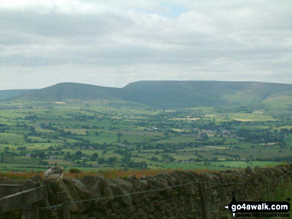
Parlick and Fair Snape Fell from Longridge Fell (Spire Hill)
The Forest of Bowland
Lancashire England


Parlick and Fair Snape Fell from Longridge Fell (Spire Hill) walking The Forest of Bowland walks in  Lancashire England

Walk Photograph by:  
Stephen Dawson (33 of 40) See Previous | Next | All


To experience views like this - walk this walk:


1. Walk l126 Longridge Fell (Spire Hill) from Jeffrey Hill
GPS Waypoint Data is included on walk l126  Longridge Fell (Spire Hill) from Jeffrey Hill map
The Forest of Bowland Lancashire England

Download walk route map pdf for walk l126  Longridge Fell (Spire Hill) from Jeffrey Hill
Superb Views of Chipping
Route Details: Jeffrey Hill, Thornley Hall, Gibbon Bridge, River Loud, River Hodder, Weedacre Farm, Longridge Fell (Spire Hill), Jeffrey Hill
Length: 9.50km (6ml) | Ascent: 262m (859ft) | Time: 3.00hrs | Grade: Walk Grade
For more walks near this one - see these interactive maps:
 OS Explorer OL41
or
 OS Landranger 103
or see walks that start at the same location or within 5 | 10 | 15 | 20 | 25 miles displayed using Google Maps.
or see a list of walks that start within 5 | 10 | 15 | 20 | 25 miles.

See more photos from walk l126 Longridge Fell (Spire Hill) from Jeffrey Hill


We are busy building the largest collection of walk related photographs available on the internet.


If you would like to see your photographs as part of this collection, send them as email attachments (configured for any computer) along with your name to the and we shall do our best to publish them.


Guide Size = at least 400pixels (wide) x 300 pixels (High)
Photos for moving panoramas must be at least 300pixels deep - we can create the side-to-side movement from static images - see example


NB. Please label each picture as clearly as possible including where each photograph was taken, which walk you were doing at the time and the view captured (if you know).


To contribute to go4awalk.com or to contact us about anything at all

- see Talk To Us. For help see Help.


NB. To see our navigational hills you must have the Macromedia Shockwave/Flash Player plug-in installed in your browser. This is free and comes as standard with later versions. If you have an early version browser - click here and follow Macromedia's installation instructions.


go4awalk.com and go4awalk.co.uk are registered trademarks of TMDH Limited.

Copyright © 2000-2008 TMDH Limited. All rights reserved.


Copyright | Terms & Conditions | Privacy Statement


Walks | Home | Log On / Accounts | Photo Gallery | Walk Ideas | Fell Facts | Places to Stay | Hill Skills | Walking Questions and Answers | Your Stories | News | Competitions | Gear Tests | Gear Guides | Gear Tips | Peaks and Mountains | Peak Bagging | Find New Walking Friends | Ordnance Survey Walking Maps | Camping | GPS Waypoints for Walking | Walk Search | go4awalk.com Help


Find a Friend to go walking with


Win fantastic walking gear with go4awalk.com
Download GPS Waypoints
GET 10% OFF Ordnance Survey Maps with FREE postage and packing
Walking Gear Tested by Walkers

Dedicated hand-held GPS
Digital Mapping
Apple ipod
Apple iphone
Nokia GPS Phone
Garmin Nuvifone GPS Phone

None of the above