3 easy to follow walk route maps of all grades that include part of The Beacons Way
Three easy-to-follow walk route maps of all grades that include part of The Beacons Way in Walk Grade Order
The Beacons Way is a 158km (98 miles) linear footpath connecting Abergavenny in Monmouthshire, with Llangadog in Carmarthenshire, England.
The Beacons Way is waymarked by named posts with a mountains and river motif.
Tap/mouse over a coloured circle (1-3 easy walks, 4-6 moderate walks, 7-9 hard walks) and click to select.
Scroll down the list of walks below & click on each walk title (in blue) to locate it on the map above.
   |
Vital Statistics:
| Length: | 8.5 miles (13.5 km) |
| Ascent: | 2,914ft (888m) |
| Time: | 6 hrs |
| Grade: |  |
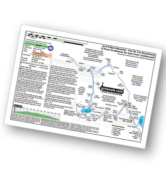
Route Summary:
Car Park SE of Llanddeusant - Nant Melyn - Sychnant - Disgwylfa - Cefn Disgwylfa - Tro'r Fan Foel - Fan Foel - The Beacons Way - Twr y Fan Foel - Fan Brycheiniog - Fan Hir - Fan Brycheiniog (Twr y Fan Foel) - Fan Foel - Bwlch Blaen Twrch - Pant y Bwlch - Picws Du (Bannau Sir Gaer) - Glastir y Picws - Cwar Du Mawr - Cwar Du Bach - Waun Lefrith (Bannau Sir Gaer) - Llyn y Fan Fach - Llethr y Llyn - Waun y Llyn - Nant Coch - Car Park SE of Llanddeusant
|
Vital Statistics:
| Length: | 15 miles (24 km) |
| Ascent: | 3,673ft (1,119m) |
| Time: | 9.25hrs |
| Grade: |  |
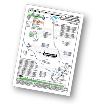
Route Summary:
Glyntawe - Afon Tawe - Ty Hendrey - Allt Fach - Fan Fechan - Fan Hir - Bwlch Giedd - The Beacons Way - Fan Brycheiniog (Twr y Fan Foel) - Fan Foel - Tro'r Fan Foel - Bwlch Blaen Twrch - Pant y Bwlch - Picws Du (Bannau Sir Gaer) - Glastir y Picws - Cwar Du Mawr - Cwar Du Bach - Waun Lefrith (Bannau Sir Gaer) - Afon Mihartfach - Carreg yr Ogof - Garreg Las (Twyn Swnd) - Pen Rhiw-goch - Twrch Fechan - Cwterydd Blaen-Twrch Fechag - Esgair Ddu (Black Mountains) - Carnau Nant-Menyn - Nant Lluestau - Afon Twrch - Afon Giedd - Pwll y Cig - Waun Fignen Felen - Disgwylfa - Twynwalter - Twyn Spratt - Afon Haffes - Dan-yr-Ogog Campsite and Showcaves - Glyntawe
|
Vital Statistics:
| Length: | 6.25 miles (10 km) |
| Ascent: | 2,130ft (649m) |
| Time: | 4½ hrs |
| Grade: |  |
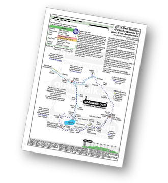
Route Summary:
Car Park SE of Llanddeusant - Nant Melyn - Sychnant - Disgwylfa - Cefn Disgwylfa - Tro'r Fan Foel - Fan Foel - The Beacons Way - Twr y Fan Foel - Bwlch Blaen Twrch - Pant y Bwlch - Picws Du (Bannau Sir Gaer) - Glastir y Picws - Cwar Du Mawr - Cwar Du Bach - Waun Lefrith (Bannau Sir Gaer) - Llyn y Fan Fach - Llethr y Llyn - Waun y Llyn - Nant Coch - Car Park SE of Llanddeusant


