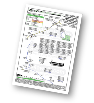
Ribblehead Viaduct
The Southern Fells Area,
The Yorkshire Dales National Park,
North Yorkshire, England

See views like this by using any of these 9 easy-to-follow circular walk route maps:
   |
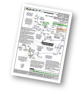
Vital Statistics:
| Length: | 7.75 miles (12.5 km) |
| Ascent: | 1,574ft (480m) |
| Time: | 4½ hrs |
| Grade: |  |

Route Summary:
Ribblehead - Blea Moor - Force Gill - Grain Ing - Whernside - Broadrake Farm - Ivescar Farm - Ribblehead
|
Vital Statistics:
| Length: | 9 miles (14.5 km) |
| Ascent: | 1,644ft (501m) |
| Time: | 5 hrs |
| Grade: | |
Route Summary:
Ribblehead - (Railway Station - After Train Journey From Horton in Ribblesdale) - B6255 - Old Hill Inn - Chapel-le-Dale - Braithwaite Wife Hole - Ingleborough - Pen-y-ghent Cafe - Horton in Ribblesdale.
|
Vital Statistics:
| Length: | 8.25 miles (13 km) |
| Ascent: | 1,932ft (589m) |
| Time: | 5 hrs |
| Grade: |  |

Route Summary:
Ribblehead - (The Old Hill Inn) - Chapel-le-Dale - Braithwaite Wife Hole - Ingleborough Nature Reserve - Humphrey Bottom - Ingleborough - Quaking Pot - Crina Bottom Farm - White Scars - High Howeth - Raven Scar - Harry Hallam's Moss - Old Hill Inn - Ribblehead
|
Vital Statistics:
| Length: | 11.5 miles (18.5 km) |
| Ascent: | 2,227ft (679m) |
| Time: | 6½ hrs |
| Grade: | |

Route Summary:
Ribblehead - (The Old Hill Inn) - Ingleborough Nature Reserve - Humphrey Bottom - Ingleborough - Simon Fell - Park Fell (Ribblehead) - New Close Farm - Ribblehead - Gunnerfleet Farm - Ivescar Farm - Broadrake Farm - Ellerbeck Farm - Jingle Pot - Chaple-le-Dale - The Old Hill Inn - Ribblehead
|
Vital Statistics:
| Length: | 10.25 miles (16.5 km) |
| Ascent: | 2,136ft (651m) |
| Time: | 6 hrs |
| Grade: | |
Route Summary:
Horton in Ribblesdale - Pen-y-ghent Cafe - Brackenbottom - Gavel Rigg - The Pennine Way - Pen-y-ghent - Hunt Pot - Hull Pot - Whitber Hill - God's Bridge - Brow Gill Beck - Nether Lodge - River Ribble - Lodge Hall (or Ingman Lodge) - Ribblehead - Ribblehead Railway Station - Train Journey - Horton in Ribblesdale Railway Station - Horton in Ribblesdale.
|
Vital Statistics:
| Length: | 10.25 miles (16.5 km) |
| Ascent: | 2,136ft (651m) |
| Time: | 6 hrs |
| Grade: | |

Route Summary:
Horton in Ribblesdale - Pen-y-ghent Cafe - Brackenbottom - Gavel Rigg - The Pennine Way - Pen-y-ghent - Hunt Pot - Hull Pot - Whitber Hill - God's Bridge - Brow Gill Beck - Nether Lodge - River Ribble - Lodge Hall (or Ingman Lodge) - Ribblehead - Ribblehead Railway Station - Train Journey - Horton in Ribblesdale Railway Station - Horton in Ribblesdale.
|
Vital Statistics:
| Length: | 8.75 miles (14 km) |
| Ascent: | 1,772ft (540m) |
| Time: | 5 hrs |
| Grade: | |

Route Summary:
Ribblehead - (Railway Station) - Blea Moor Common - Blue Clay Ridge - Force Gill - Grain Ing - Greenset Moss - Whernside - Broadrake Farm - Bruntscar Farm - Philpin Farm - Scar Close - Ellerbeck Pasture - Ribblehead
|
Vital Statistics:
| Length: | 14 miles (22.5 km) |
| Ascent: | 3,207ft (977m) |
| Time: | 8½ hrs |
| Grade: |  |

Route Summary:
Horton in Ribblesdale - Railway Station - Train Journey - Ribblehead Railway Station - Ribblehead - Blea Moor - Whernside - Broadrake Farm - Ribblehead - Blea Moor - Whernside - Broadrake Farm - Chapel-le-Dale - Braithwaite Wife Hole - Ingleborough - Pen-y-ghent Cafe - Horton in Ribblesdale.
|
Vital Statistics:
| Length: | 24 miles (38.5 km) |
| Ascent: | 5,297ft (1,614m) |
| Time: | 14 hrs |
| Grade: |  |

Route Summary:
Horton in Ribblesdale - Pen-y-ghent Cafe - Brackenbottom - Gavel Rigg - The Pennine Way - Pen-y-ghent - Hunt Pot - Hull Pot - Whitber Hill - God's Bridge - Brow Gill Beck - Nether Lodge - River Ribble - Lodge Hall (or Ingman Lodge) - Ribblehead - Blea Moor - Whernside - Broadrake Farm - Chapel-le-Dale - Braithwaite Wife Hole - Ingleborough - Pen-y-ghent Cafe - Horton in Ribblesdale.
Send us your photographs and pictures of walks and hikes in the British countryside
If you would like to see your digital photographs as part of this collection, please send them as email attachments (configured for any computer) along with your name to:
and we shall do our best to publish them.
(Guide Resolution = 300dpi. At least = 587 pixels (wide) x 440 pixels (high).)

You can also submit photos via our Facebook Page.
NB. Please indicate where each photo was taken.
NB. To see photographs and pictures from a particular walk choose your walk from Walks or use our Walk Search facility.
To see photographs and pictures on, of or from a particular Mountain, Peak, Top or Hill select from Peaks & Mountains' or enter the Mountain, Peak, Top or Hill Name into our 'Photo Search facility.


