
![]()
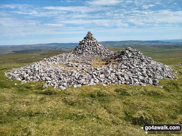
Proctor High Mark
531m (1743ft)
The Southern Dales Area, The Yorkshire Dales, North Yorkshire, England England

Not familiar with this top?
   |
|---|
Vital Statistics:
| Length: | 7.5mls (12km) |
|---|---|
| Ascent: | 909ft (277m) |
| Time: | 3.75hrs |
| Grade: |  (Moderate) (Moderate) |
Route Summary:
Street Gate - Gordale Beck - East Great Close - Clapham High Mark - Lee Gate High Mark - Rabbit Rock - Proctor High Mark - Tommy High Pasture - Mastiles Lane - Street Gate
|
|---|
Vital Statistics:
| Length: | 8.75mls (14km) |
|---|---|
| Ascent: | 1,162ft (354m) |
| Time: | 4½ hrs |
| Grade: |  (Moderate) (Moderate) |

Route Summary:
Street Gate - Great Close Plantation - Great Close Scar - Middle House Farm - Low Midge Hills - High Midge Hills - Middle House - Out Pasture - Middle House Hill - Dew Bottoms - Parson's Pulpit - Lee Gate High Mark - Rabbit Rock - Proctor High Mark - Tommy High Pasture - Mastiles Lane - Street Gate
See Proctor High Mark and the surrounding tops on our free-to-access 'Google Style' Peak Bagging Maps:
The Southern Dales Area of The Yorkshire Dales National Park
Less data - quicker to download
The Whole of The Yorkshire Dales National Park
More data - might take a little longer to download
See Proctor High Mark and the surrounding tops on our downloadable Peak Bagging Map in PDF format:

NB: Whether you print off a copy or download it to your phone, this PDF Peak Baggers' Map might prove incredibly useful when your are up there on the tops and you cannot get a phone signal.
You can find Proctor High Mark & all the walks that climb it on these unique free-to-access Interactive Walk Planning Maps:
1:25,000 scale OS Explorer Map (orange/yellow covers):
1:50,000 scale OS Landranger Map (pink/magenta covers):
 Fellow go4awalkers who have already walked, climbed, summited & bagged Proctor High Mark
Mark Davidson walked up Proctor High Mark on June 2nd, 2020 [from/via/route] Walk ny172 Parson's Pulpit & Proctor High Mark from Street Gate [with] Alone [weather] Baking hot - First proper walk after Covid-19 lockdown. It was good to be out.
Tony Rogerson climbed it on April 16th, 2016 [from/via/route] Mastiles Lane Proctor High Mark Parsons Pulpit [with] Caz Floss [weather] Sunny but chilly & breezy
Patrick Rogozinski has walked, climbed & bagged Proctor High Mark.
To add (or remove) your name and experiences on this page - Log On and edit your Personal Mountain Bagging Record
More Photographs & Pictures of views from, on or of Proctor High Mark
Send us your photographs and pictures on, of, or from Proctor High Mark
If you would like to add your walk photographs and pictures to this page, please send them as email attachments (configured for any computer) along with your name to:
and we shall do our best to publish them.
(Guide Resolution = 300dpi. At least = 660pixels (wide) x 440 pixels (high).)

You can also submit photos via our Facebook Page.
NB. Please indicate where each photo was taken and whether you wish us to credit your photos with a Username or your First Name/Last Name.


