UK Postcode TA9 - The 30 nearest easy-to-follow, circular walk route maps to you
The thirty nearest easy-to-follow, circular walk route maps to you in UK Postcode TA9 in Walk Grade Order
The UK cities, towns and villages in Somerset, England that have TA9 in their UK Postcode include:
• Bason Bridge • Brent Knoll • Cote • East Brent • East Huntspill • Edithmead • Highbridge • Huntspill • Mark • Mark Causeway • Watchfield • West Huntspill •
Not familiar with the area around TA9?
See these 30 nearest walks to UK Postcode TA9 on a google map
   |
Vital Statistics:
| Length: | 7.5 miles (12 km) |
| Ascent: | 656 ft (200 m) |
| Time: | 3.25 hrs |
| Grade: |  |

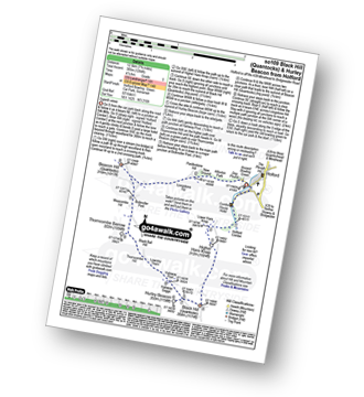
Route Summary:
Cheddar Gorge - Black Rock Nature Reserve - Long Wood Nature Reserve - Tyning's Farm - Beacon Batch (Mendip Hills) - Charterhouse - Velvet Bottom Nature Reserve - Black Rock Nature Reserve - Cheddar Gorge
|
Vital Statistics:
| Length: | 7.75 miles (12.5 km) |
| Ascent: | 1,264 ft (385 m) |
| Time: | 4.25 hrs |
| Grade: |  |
Route Summary:
Holford - Holford Combe - Lower Hare Knap - Higher Hare Knap - Black Hill (Quantocks) - Hurley Beacon - Halsway Soggs - Halsway Post - Thorncombe Hill - Black Ball Hill - Thorncombe Barrow - Weacombe Hill - Bicknoller Post - Beacon Hill (Quantocks) - Longstone Hill - Alfoxton Park - Holford
|
Vital Statistics:
| Length: | 5.5 miles (8.5 km) |
| Ascent: | 722 ft (220 m) |
| Time: | 2.75 hrs |
| Grade: | |

Route Summary:
Easton-in-Gordano - The Gordano Round - Hails Wood - The Bottoms - Summer House Wood - Windmill Hill - Buddings Wood - Downs School - Charlton Farm Children's Hospice - Prior's Wood - Portbury - Portbury Standing Stone - Gordano Services - Easton-in-Gordano
|
Vital Statistics:
| Length: | 5.75 miles (9.5 km) |
| Ascent: | 600 ft (183 m) |
| Time: | 2.75 hrs |
| Grade: | |

Route Summary:
Mells - Wadbury Hill Fort - Mells Stream - Wadbury Valley - Great Elm - The Macmillan Way - Buckland Brook - Buckland Dinham - Clareham Lane - Hill House Farm - Conduit Bridge - Mells
|
Vital Statistics:
| Length: | 9.5 miles (15 km) |
| Ascent: | 2,038 ft (621 m) |
| Time: | 5½ hrs |
| Grade: |  |

Route Summary:
Luccombe - Luccombe Plantation - Webbers Post - Dicky's Path - Hollow Combe - Dunkery Beacon - Little Rowbarrow - Great Rowbarrow - Lang Combe Head - Cloutsham Gate - Stoke Pero Church - Prickslade - Cloutsham Farm - East Water Valley - Webbers Post - Horner Plantataion - Luccombe
|
Vital Statistics:
| Length: | 6.75 miles (11 km) |
| Ascent: | 1,254 ft (382 m) |
| Time: | 3.75 hrs |
| Grade: |  |
Route Summary:
Webbers Post - Dicky's Path - Hollow Combe - Dunkery Beacon - Little Rowbarrow - Great Rowbarrow - Lang Combe Head - Cloutsham Gate - Cloutsham Farm - East Water Valley - Webbers Post
|
Vital Statistics:
| Length: | 6 miles (9.5 km) |
| Ascent: | 1,408 ft (429 m) |
| Time: | 3½ hrs |
| Grade: | |

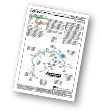
Route Summary:
Bossington - Allerford - Selworthy - Selworthy Beacon - The South West Coast Path - Hurlstone Combe - Hurlstone Point - Porlock Bay - Bossington
|
Vital Statistics:
| Length: | 5.75 miles (9 km) |
| Ascent: | 1,083 ft (330 m) |
| Time: | 3.25 hrs |
| Grade: | |
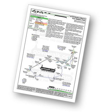
Route Summary:
Bury - River Haddeo - Hartford Bottom - Hartford Lodge - Pulham River - Upton Dam - Wimbleball Lake - Haddon Hill - Hadborough (Haddon Hill) - Hadborough Plantation - Haddon Farm - Bury
|
Vital Statistics:
| Length: | 5 miles (8 km) |
| Ascent: | 558 ft (170 m) |
| Time: | 2½ hrs |
| Grade: | |
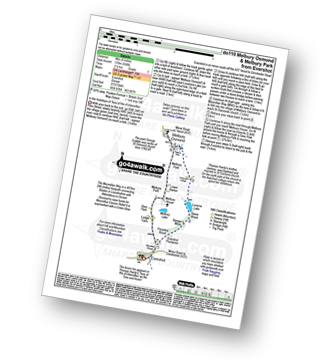
Route Summary:
Evershot - Paradise Wood - Evershot Plantation - Banger's Moor - Sares Wood - Lucerne Lake - Melbury Park - The Macmillan Way - Melbury Osmond - Lower Barton - Melbury House - Evershot
|
Vital Statistics:
| Length: | 8.75 miles (14 km) |
| Ascent: | 1,634 ft (498 m) |
| Time: | 4.75 hrs |
| Grade: | |

Route Summary:
Withypool - The Two Moors Way - Withypool Hill - Westwater Farm - Parsonage Down - River Barle - Tarr Steps - Knaplock Wood - Withypool
|
Vital Statistics:
| Length: | 5.5 miles (9 km) |
| Ascent: | 630 ft (192 m) |
| Time: | 2.75 hrs |
| Grade: | |

Route Summary:
Askerswell - South Eggardon Farm - North Eggardon Farm - Eggardon Hill Fort - Eggardon Hill - Haydon Down - Stancombe Farm - Askerswell Down - Nallers Farm - Askerswell
|
Vital Statistics:
| Length: | 5 miles (8 km) |
| Ascent: | 1,708 ft (521 m) |
| Time: | 3.75 hrs |
| Grade: | |

Route Summary:
Lynmouth - The East Lyn River - Wester Wood - Horner's Neck Wood - Watersmeet - Watersmeet House - Trilly - Countisbury - Butter Hill - The Sought West Coast Path - Lower Blackhead - Sillery Sands - Black Rocks - Point Perilous - Lynmouth
|
Vital Statistics:
| Length: | 10.5 miles (17 km) |
| Ascent: | 374 ft (114 m) |
| Time: | 4.25 hrs |
| Grade: | |
Route Summary:
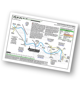
Clytha National Trust Car Park - The River Usk - The Usk Valley Walk - Pant-y-Goitre - Llangatwg Dyffryn Wysg - Llanellen - Llanover - Pant-y-Goitre - Clytha National Trust Car Park
|
Vital Statistics:
| Length: | 5.5 miles (9 km) |
| Ascent: | 768 ft (234 m) |
| Time: | 3 hrs |
| Grade: | |

Route Summary:
Clytha National Trust Car Park - The River Usk - Afon Wysg - The Usk Valley Walk - Bettws Newydd - Coed y Bwnydd (fort) - Clytha Hill - Great House Farm - Hillgrove Farm - Clytha - Clytha National Trust Car Park
|
Vital Statistics:
| Length: | 5.5 miles (8.5 km) |
| Ascent: | 1,493 ft (455 m) |
| Time: | 3½ hrs |
| Grade: | |

Route Summary:
Lynton - The Danes Or Valley Of Rocks - Six Acre Wood - The South West Coast Path - Lee Bay - Lee Abbey - Castle Rock - Rugged Jack - Wringcliff Bay - Ruddy Ball - Lynmouth - Lynton
Not familiar with the area around TA9?
See these 30 nearest walks to UK Postcode TA9 on a google map
|
Vital Statistics:
| Length: | 4.75 miles (7.5 km) |
| Ascent: | 811 ft (247 m) |
| Time: | 2½ hrs |
| Grade: | |

Route Summary:
West Bexington - Tulks Hill - Abbotsbury Castle (Iron Age Fort) - The South West Coast Path - Chesil Beach - West Bexington
|
Vital Statistics:
| Length: | 6.75 miles (11 km) |
| Ascent: | 1,208 ft (368 m) |
| Time: | 3.75 hrs |
| Grade: | |

Route Summary:
Shobrooke - Shobrook Lake - Coombe Barton - Stockleigh Wood - Parsonage Copse - Stockleigh Pomeroy - Stong's Brake - Raddon Hills - Raddon Court - West Raddon - Exeter Hill Cross - Shobrooke
|
Vital Statistics:
| Length: | 7 miles (11 km) |
| Ascent: | 1,037 ft (316 m) |
| Time: | 3½ hrs |
| Grade: | |

Route Summary:
Martinstown (or Winterborne St Martin) - Grove Hill Bottom - Great Hill - South Dorset Ridgeway - Corton Down - Bronkham Hill - Jubilee Trail - Blackdown - Smitten Corner - Black Down (Hardy Monument) - Bronkham Hill - Pen Barn Farm - Grove Hill Bottom - Martinstown (or Winterborne St Martin)
|
Vital Statistics:
| Length: | 7.25 miles (11.5 km) |
| Ascent: | 847 ft (258 m) |
| Time: | 3½ hrs |
| Grade: | |
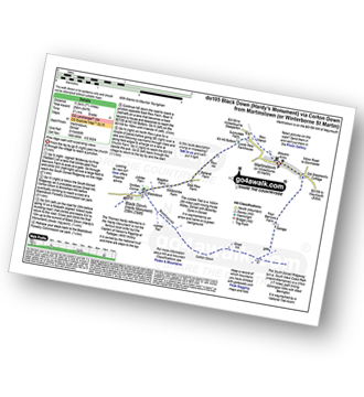
Route Summary:
Martinstown (or Winterborne St Martin) - Four Barrows Farm - Great Hill - South Dorset Ridgeway - Corton Down - Bronkham Hill - Jubilee Trail - Blackdown - Smitten Corner - Black Down (Hardy Monument) - East Rew Farm - Rew Manor - Martinstown (or Winterboune St Martin).
|
Vital Statistics:
| Length: | 8.25 miles (13 km) |
| Ascent: | 1,070 ft (326 m) |
| Time: | 4 hrs |
| Grade: | |

Route Summary:
Abbotsbury - The Macmillan Way - Abbotsbury Plain - The South Dorset Ridgeway - Abbotsbury Castle (Iron Age Fort) - Tulks Hill - West Bexington - The South West Coast Path - Chesil Beach - Abbotsbury
|
Vital Statistics:
| Length: | 7.25 miles (11.5 km) |
| Ascent: | 1,158 ft (353 m) |
| Time: | 3.75 hrs |
| Grade: | |

Route Summary:
Abbotsbury - The Macmillan Way - Abbotsbury Plains - Borad Coppice - Gorwell Farm - Kingstone Russel Stone Circle - Tenants Hill - Littlebredy - Topparts Dairy - The South Dorset Ridgeway - White Hill (Abbotsbury) - Abbotsbury
|
Vital Statistics:
| Length: | 6.25 miles (10 km) |
| Ascent: | 994 ft (303 m) |
| Time: | 3.25 hrs |
| Grade: | |

Route Summary:
Abbotsbury - The Macmillan Way - Abbotsbury Plain - The South Dorset Ridgeway - Abbotsbury Castle (Iron Age Fort) - Tulks Hill - Labour in Vain Farm - East Bexington Farm - The South West Coast Path - Chesil Beach - Abbotsbury
|
Vital Statistics:
| Length: | 4.75 miles (7.5 km) |
| Ascent: | 499 ft (152 m) |
| Time: | 2.25 hrs |
| Grade: |  |
Route Summary:
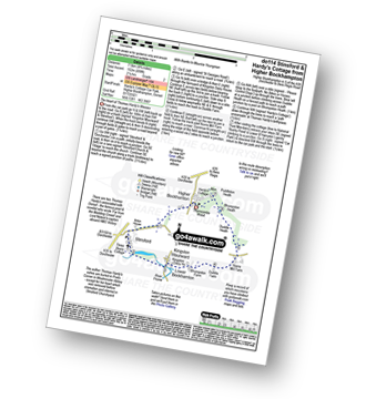
Higher Bockhampton - Stinsford - Lower Bockhampton - Kingston Maurward - Duddle Heath - Bhompston Heath - Puddleton Heath - Hardy's Cottage (Thomas Hardy's Birthplace) - Thorncombe Wood - Higher Bockhampton
|
Vital Statistics:
| Length: | 5 miles (8 km) |
| Ascent: | 561 ft (171 m) |
| Time: | 2½ hrs |
| Grade: | |
Route Summary:
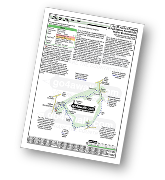
Higher Bockhampton - Thorncombe Wood - Hardy's Cottage (Thomas Hardy's Birthplace) - Bhompston Heath - Duddle Heath - Castle Hill - Beacon Corner - Beacon Hill - Puddletown Forest - Hardy's Cottage (Thomas Hardy's Birthplace) - Higher Bockhampton
|
Vital Statistics:
| Length: | 7.25 miles (11.5 km) |
| Ascent: | 643 ft (196 m) |
| Time: | 3.25 hrs |
| Grade: | |

Route Summary:
Higher Bockhampton - Stinsford - Lower Bockhampton - Kingston Maurward - River Frome - Duddle Heath - Castle Hill - Beacon Corner - Beacon Hill - Puddletown Forest - Hardy's Cottage (Thomas Hardy's Birthplace) - Higher Bockhampton
|
Vital Statistics:
| Length: | 4.75 miles (7.5 km) |
| Ascent: | 1,405 ft (428 m) |
| Time: | 3.25 hrs |
| Grade: | |

Route Summary:
Uley - Uley Bury Hill Fort - Cliff Wood - Crawley Barns - The Cotswolds Way - Hodgecombe Farm - Cam Long Down - Peaked Down - Uleyfield - Downham Hill (Smallpox Hill) - Hydegate - Uley Bury Hill Fort - Uley
|
Vital Statistics:
| Length: | 5 miles (8 km) |
| Ascent: | 1,155 ft (352 m) |
| Time: | 3 hrs |
| Grade: | |

Route Summary:
B4521 Layby - Llanddewi Skirrid - Skirrid Fawr (Ysgyryd Fawr) - Llwyn Franc - Top Cottage - Top Cottage - Pant-Skirrid - B4521 Layby
|
Vital Statistics:
| Length: | 5.25 miles (8.5 km) |
| Ascent: | 322 ft (98 m) |
| Time: | 2.25 hrs |
| Grade: | |
Route Summary:
Tolpuddle - Southover Heath - Clyff Copse - Tincleton Hang - Cowpound Wood - Athelhamton - Park Farm - Tolpuddle
|
Vital Statistics:
| Length: | 5.25 miles (8.5 km) |
| Ascent: | 1,555 ft (474 m) |
| Time: | 3½ hrs |
| Grade: | |

Route Summary:
Porth-y-parc Farm - The Park - Twyn Gwyn - Sugar Loaf (Y Fal) - Deri - Sunny View - Sunny Vale - Porth-y-parc Farm
|
Vital Statistics:
| Length: | 8.25 miles (13 km) |
| Ascent: | 1,326 ft (404 m) |
| Time: | 4.25 hrs |
| Grade: | |
Route Summary:
Ponsticill - Baltic Quarry - Cefn Yr Ystrad - Cwar Yr Ystrad - Cwar Yr Hendre - Gwaun Danydarren - Gwaun Nant Ddu - Cwm Callan - Dolygaer - Pontsticill Reservoir - Brecon Mountain Railway - Pontsticill Railway Station - Ponsticill
Not familiar with the area around TA9?
See these 30 nearest walks to UK Postcode TA9 on a google map


