UK Postcode PO6 - The 30 nearest easy-to-follow, circular walk route maps to you
The thirty nearest easy-to-follow, circular walk route maps to you in UK Postcode PO6 in Walk Grade Order
The UK cities, towns and villages in Hampshire, England that have PO6 in their UK Postcode include:
• Cosham • Drayton • Wymering •
Not familiar with the area around PO6?
See these 30 nearest walks to UK Postcode PO6 on a google map
   |
Vital Statistics:
| Length: | 5.5 miles (8.5 km) |
| Ascent: | 3 ft (136 m) |
| Time: | 2½ hrs |
| Grade: |  |
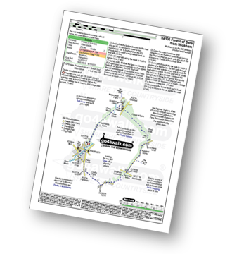
Route Summary:
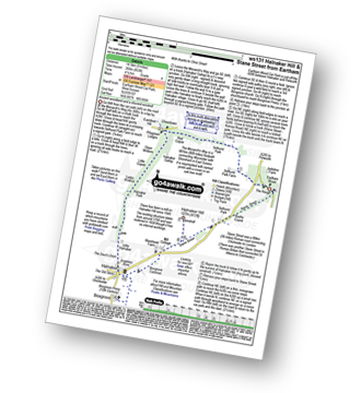
Wickham - Castle Farm - Wickham Common - Mellishes Bottom - Pillgrims' Way - Hundred Acres - Forest of Bere West Walk - Close Wood - Northfields Farm - Wickham
|
Vital Statistics:
| Length: | 5 miles (8 km) |
| Ascent: | 374 ft (114 m) |
| Time: | 2.25 hrs |
| Grade: | |

Route Summary:
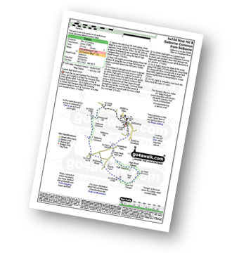
Bramdean - Alresford Lane - Cheriton Wood - Copwer Cottage - Bramdean Common - Wood Farm - Bramdean
|
Vital Statistics:
| Length: | 7.75 miles (12.5 km) |
| Ascent: | 610 ft (186 m) |
| Time: | 3½ hrs |
| Grade: |  |
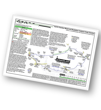
Route Summary:
Cheriton - The Wayfarer's Walk - Hinton Lane - Upper Lamborough Lane - Broad Lane - Cheriton Wood - Alresford Lane - Copwer Cottage - Bramdean Common - Wood Farm - Bramdean - Hinton Ampner - New Cheriton - Cheriton
|
Vital Statistics:
| Length: | 5 miles (8 km) |
| Ascent: | 387 ft (118 m) |
| Time: | 2.25 hrs |
| Grade: | |

Route Summary:
Cheriton - The Wayfarer's Walk - Hinton Lane - Upper Lamborough Lane - Broad Lane - Cheriton Wood - Alresford Lane - New Cottages - Bramdean House - Bramdean - Hinton Ampner - New Cheriton - Cheriton
|
Vital Statistics:
| Length: | 4.75 miles (7.5 km) |
| Ascent: | 443 ft (135 m) |
| Time: | 2.25 hrs |
| Grade: | |
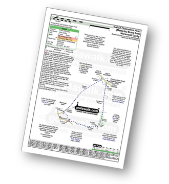
Route Summary:
Morestead - Old Copse Down - Old Down Wood - Old Down Plantation - Longwood Warren - The Allan King's Way - Cheesefoot Head (Matterley Bowl) - Fawley Down - Morestead Down - Morestead
|
Vital Statistics:
| Length: | 5.25 miles (8.5 km) |
| Ascent: | 994 ft (303 m) |
| Time: | 3 hrs |
| Grade: |  |
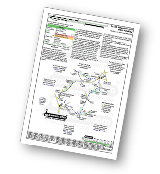
Route Summary:
Hawkley - The Hangers Way - Lower Oakshott Farm - Wheatham Hill - Edward Thomas Memorial - Froxfield - Warren Corner - Wealdon Edge Hangers Nature Reserve - Hawkley Hanger - Hawkley
|
Vital Statistics:
| Length: | 10 miles (16 km) |
| Ascent: | 985 ft (300 m) |
| Time: | 4.75 hrs |
| Grade: |  |

Route Summary:
Cheesefoot Head Car Park - Cheesefoot Head (Matterley Bowl) - Fawley Down - Hydes Cottages - Morestead - Old Down Copse - Bushy Copse - Longwood House - Longwood Dead Farm - Lane End - The South Downs Way - Holden Farm - Gander Down - Temple Valley - Cheesefoot Head Car Park
|
Vital Statistics:
| Length: | 5.25 miles (8.5 km) |
| Ascent: | 896 ft (273 m) |
| Time: | 2.75 hrs |
| Grade: | |

Route Summary:
Godshill - Godshill Park - Stenbury Trail - Freemantle Gate - Appuldurcombe Farm - Appuldurcombe House - Span Lodge Farm - Stenbury Down - Appuldurcombe Down - Sainham Farm - Godshill Church - Godshill
|
Vital Statistics:
| Length: | 9 miles (14.5 km) |
| Ascent: | 853 ft (260 m) |
| Time: | 4.25 hrs |
| Grade: | |
Route Summary:
Eartham Woods - The Monarch's Way - Selhurst Park Farm - Red Copse - Chisledown - Eastdean Hill - Pillygreen Lodges - Halnaker Gallop - Open Winkins - Ladys Winkins - Little Copse - Little Halnaker - Halnaker - Boxgrove Priory - Boxgrove Commoon - Warehead Farm - Halnaker Hill - Stane Street (Roman Road) - Bushy Copse - Eartham Woods
|
Vital Statistics:
| Length: | 9.75 miles (15.5 km) |
| Ascent: | 1,126 ft (343 m) |
| Time: | 4.75 hrs |
| Grade: | |

Route Summary:
Winchester - Tun Bridge - The Itchen Way - Itchen Navigation - St Catherine's Hill - Pilgrims' Trail - Twyford Down - Morestead Down - Hydes Cottages - Fawley Down - The Allan King's Way - Cheesefoot Head Car Park - Cheesefoot Head (Matterley Bowl) - The South Downs Way - The Pilgrim's Way - Telegraph Hill - Little Golders - Chilcomb - Highcliffe - The Soke - City Mill - Wharf Bridge - Tun Bridge - Winchester
|
Vital Statistics:
| Length: | 5.5 miles (9 km) |
| Ascent: | 738 ft (225 m) |
| Time: | 2.75 hrs |
| Grade: | |
Route Summary:
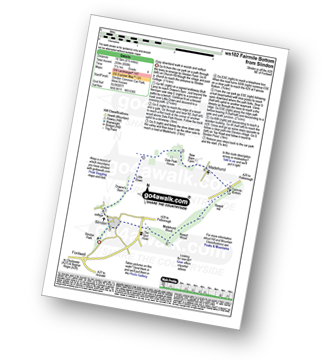
Selborne - The Hangers Way - High Common - High Wood Hanger - Noar Hill - Noar Hill Hanger - Bridleway Wood - Selborne Common - Coneycroft Hill - Selborne
|
Vital Statistics:
| Length: | 7 miles (11 km) |
| Ascent: | 515 ft (157 m) |
| Time: | 3 hrs |
| Grade: | |

Route Summary:
Selborne - Dorton - Oakhanger Stream - Oakhanger - Binswood Farm - Shortheath - The Hangers Way - Pheasant Wood - Wick Hill Hanger - High Candovers - Wick Wood - Coombe Wood - Long Lyth - Selborne
|
Vital Statistics:
| Length: | 10 miles (16 km) |
| Ascent: | 1,237 ft (377 m) |
| Time: | 4 hrs |
| Grade: | |

Route Summary:
Slindon - Park Pale - Slindon Woods - The Reeds - Nore Hill - The Folly (Nore Folly) - Court Hill Farm - Down's Barn - Little Down. Dale Park House - Madehurst - Fairmile Bottom - Rewell Hill - Reweel Hill - Madehurst Wood - Slindon
|
Vital Statistics:
| Length: | 5 miles (8 km) |
| Ascent: | 522 ft (159 m) |
| Time: | 2½ hrs |
| Grade: | |

Route Summary:
Slindon - Park Pale - Slindon Woods - The Reeds - Nore Hill - The Folly (Nore Folly) - Court Hill Farm Slindon.
|
Vital Statistics:
| Length: | 3.75 miles (6 km) |
| Ascent: | 312 ft (95 m) |
| Time: | 1.75 hrs |
| Grade: | |

Route Summary:
Slindon - Park Pale - Slindon Woods - The Reeds - Row's Bar - Court Hill Farm - Slindon
Not familiar with the area around PO6?
See these 30 nearest walks to UK Postcode PO6 on a google map
|
Vital Statistics:
| Length: | 6.5 miles (10.5 km) |
| Ascent: | 850 ft (259 m) |
| Time: | 3.25 hrs |
| Grade: | |
Route Summary:
Slindon - Down's Barn - Little Down. Dale Park House - Madehurst - Fairmile Bottom - Rewell Hill - Reweel Hill - Madehurst Wood - Slindon
|
Vital Statistics:
| Length: | 6.25 miles (10 km) |
| Ascent: | 40 ft (12 m) |
| Time: | 2.25 hrs |
| Grade: |  |
Route Summary:
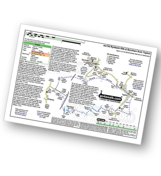
Yapton - Yapton Gardens - Bilsham - Ryebank Rife - Weststone Bridge - Westfield - Lidsey Rife - The Portsmouth and Arundel Navigation Canal - Tilebarn Farm - Barnham - Yapton
|
Vital Statistics:
| Length: | 5.5 miles (8.5 km) |
| Ascent: | 263 ft (80 m) |
| Time: | 2.25 hrs |
| Grade: | |
Route Summary:
Chawton - Alton - Jane Austen's House Museum - The St Swithun's Way - Lower Farringdon - Upper Farringdon - Caker Stream - Round Groves Copse - Peck Copse - Shepherd's Court - Eastfield Farm - Chawton
|
Vital Statistics:
| Length: | 7.5 miles (12 km) |
| Ascent: | 673 ft (205 m) |
| Time: | 3.75 hrs |
| Grade: | |

Route Summary:
Chawton - Alton - Jane Austen's House Museum - The St Swithun's Way - Park Cottage - Upper Woodside Farm - New Copse - Dell Piece - Weathermore Copse - Medstead and Four Marks - Watercress Railway Line - Chawton Park Wood - Alton - Chawton
|
Vital Statistics:
| Length: | 3.5 miles (5.5 km) |
| Ascent: | 16 ft (5 m) |
| Time: | 1½ hrs |
| Grade: | |
Route Summary:
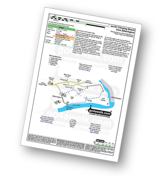
Climping Beach - Atherington - Kent's Farm - Ryebank Rife - River Arun - Littlehampton - Littlehampton Harbour - The Mill - Climping - Climping Beach
|
Vital Statistics:
| Length: | 4.75 miles (7.5 km) |
| Ascent: | 475 ft (145 m) |
| Time: | 2½ hrs |
| Grade: | |
Route Summary:
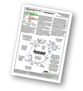
Arundel - Arundel Castle - The River Arun - Wildfowl Reserve - Offham - Offham Hanger - Swanbourne Lake - Arundel Park - The Monarch''s Way - Hiorne Tower - Arundel Cathedral - Arundel Chapel - Arundel Castle - Arundel
|
Vital Statistics:
| Length: | 6.75 miles (11 km) |
| Ascent: | 715 ft (218 m) |
| Time: | 3.25 hrs |
| Grade: | |
Route Summary:
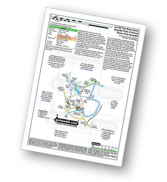
Arundel - Arundel Castle - Swanbourne Lake - Arundel Park - The Monarch''s Way - Hiorne Tower - Duke's Plantation - Dry Lodge Plantation - South Wood - The River Arun - South Stoke - The River Arun - Offham - Wildfowl Reserve - Arundel
|
Vital Statistics:
| Length: | 9 miles (14.5 km) |
| Ascent: | 948 ft (289 m) |
| Time: | 4.25 hrs |
| Grade: | |
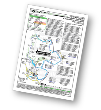
Route Summary:
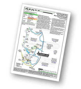
Arundel - Arundel Castle - Swanbourne Lake - Arundel Park - The Monarch''s Way - Hiorne Tower - Duke's Plantation - Dry Lodge Plantation - South Wood - The River Arun - South Stoke - Burpham - Arundel
|
Vital Statistics:
| Length: | 5.5 miles (9 km) |
| Ascent: | 397 ft (121 m) |
| Time: | 2½ hrs |
| Grade: | |
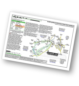
Route Summary:
Lyndhurst - Emery Down - White Moor - Buckhill Hole - The New Forest - Highland Water - Roman Bridge - Bramble Hill - Allum Green House - Cut Walk - Swan Green - Lyndhurst
|
Vital Statistics:
| Length: | 7.25 miles (11.5 km) |
| Ascent: | 1,303 ft (397 m) |
| Time: | 4 hrs |
| Grade: | |

Route Summary:
Freshwater Bay - Watcombe Bay - Tennyson Down - Tennyson's Monument - Highdown Cliffs - New Battery - Scratchell's Bay - Old Battery - The Needles - Coastguard Cottages - West High Down - Nodewell Farm - Freshwater Bay
|
Vital Statistics:
| Length: | 6.25 miles (10 km) |
| Ascent: | 660 ft (201 m) |
| Time: | 3 hrs |
| Grade: | |

Route Summary:
Amberley Museum - Amberley Railway Station - Houghton Bridge - The River Arun - North Stoke - Camp Hill - The South Downs Way - Amberley Village - Amberley Castle - The River Arun - Amberley.
|
Vital Statistics:
| Length: | 5.5 miles (9 km) |
| Ascent: | 630 ft (192 m) |
| Time: | 2½ hrs |
| Grade: | |
Route Summary:
Amberley Museum - Amberley Railway Station - Houghton Bridge - The River Arun - North Stoke - Camp Hill - The South Downs Way - High Titten - Foxleigh Down - The River Arun - Amberley.
|
Vital Statistics:
| Length: | 7.75 miles (12.5 km) |
| Ascent: | 932 ft (284 m) |
| Time: | 3.75 hrs |
| Grade: | |
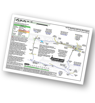
Route Summary:
Storrington - Greyfriars Farm - Chantry Hill - Kithurst Hill - The South Downs Way - Springhead Hill - Rackham Hill - Rackham - Parham House - Cootham - Storrington
|
Vital Statistics:
| Length: | 6 miles (9.5 km) |
| Ascent: | 262 ft (80 m) |
| Time: | 2½ hrs |
| Grade: | |

Route Summary:
Ashington - Mitchbourne Farm - Greenhurst Farm - Abingworth - Thakeham - Warminghurst - Ashington
|
Vital Statistics:
| Length: | 5 miles (8 km) |
| Ascent: | 190 ft (58 m) |
| Time: | 2 hrs |
| Grade: | |

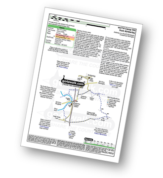
Route Summary:
Winchfield Hurst - Barley Mow Bridge - The Basingstoke Canal - Stacey's Bridge - The Three Castles Path - Baseley's Bridge - Sprat's Hatch Bridge - Sprat's Hatch Farm - Tundry Pond - Parsonage Copse - Double Bridge Farm - Whitlow Alders - Crookham Village - Brook Hill - Brook Meadow Farm - Dogmersfield - Norman's Green - Pilcot Farm - Winchfield Hurst
Not familiar with the area around PO6?
See these 30 nearest walks to UK Postcode PO6 on a google map


