UK Postcode PL6 - The 30 nearest easy-to-follow, circular walk route maps to you
The thirty nearest easy-to-follow, circular walk route maps to you in UK Postcode PL6 in Walk Grade Order
The UK cities, towns and villages in Devon, England that have PL6 in their UK Postcode include:
• Bickleigh • Clearbrook • Crownhill • Egg Buckland • Maristow • Roborough •
Not familiar with the area around PL6?
See these 30 nearest walks to UK Postcode PL6 on a google map
   |
Vital Statistics:
| Length: | 6 miles (9.5 km) |
| Ascent: | 1,382 ft (421 m) |
| Time: | 3.75 hrs |
| Grade: |  |

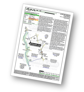
Route Summary:
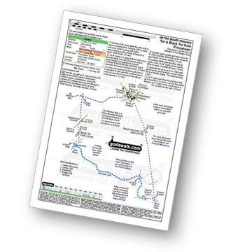
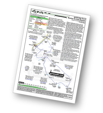
Cawsand - The South West Coast Path - Cawsand Bay - Pier Cellars - Penlee Point - Homebarton Hill - Rame Head - Queener Point - Polhawn Cove - Captain Blake's Point - Wiggle Cliff - Wiggle - Wringford Downs Cawsand.
|
Vital Statistics:
| Length: | 11 miles (17.5 km) |
| Ascent: | 1,526 ft (476 m) |
| Time: | 5½ hrs |
| Grade: |  |

Route Summary:
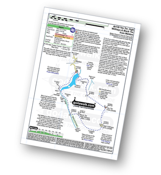
Princetown - North Hessary Tor - Rundlestone - Little Mis Tor - Great Mis Tor - Merrivale Army Firing Range - Greena Ball - River Walkham - Langstone Mor Stone Circle - Petertavy Great Common - Roos Tor - Great Staple Tor - Middle Staple Tor - Grimstone and Sortridge Leat - River Walkham - Yellowmeade Farm - Foggintor Quarry - The Dartmoor Way - Princetown
|
Vital Statistics:
| Length: | 7.75 miles (12.5 km) |
| Ascent: | 643 ft (196 m) |
| Time: | 3½ hrs |
| Grade: |  |
Route Summary:
Princetown - South Hessary Tor - Siward's Cross - Nun's Cross - Devonport Leat - Raddick Hill - River Meavey - Black Tor (Walkhampton Common) - The Dartmoor Way - Princetown
|
Vital Statistics:
| Length: | 4.75 miles (7.5 km) |
| Ascent: | 525 ft (160 m) |
| Time: | 2.25 hrs |
| Grade: |  |

Route Summary:
Princetown - North Hessary Tor - Rundlestone - Yellowmeade Farm - Foggintor Quarry - The Dartmoor Way - Princetown
|
Vital Statistics:
| Length: | 6.25 miles (10 km) |
| Ascent: | 1,139 ft (347 m) |
| Time: | 3½ hrs |
| Grade: | |
Route Summary:
Merrivale - Little Mis Tor - Great Mis Tor - Merrivale Army Firing Range - Greena Ball - River Walkham - Langstone Moor Stone Circle - Petertravy Great Common - Roos Tor - Great Staple Tor - Middle Staple Tor - Grimstone and Sortridge Leat - River Walkham - Merrivale
|
Vital Statistics:
| Length: | 5 miles (8 km) |
| Ascent: | 748 ft (228 m) |
| Time: | 2.75 hrs |
| Grade: | |

Route Summary:
Merrivale - Little Mis Tor - Great Mis Tor - Merrivale Army Firing Range - Greena Ball - River Walkham - Blowing House - Merrivale
|
Vital Statistics:
| Length: | 7.25 miles (11.5 km) |
| Ascent: | 1,260 ft (384 m) |
| Time: | 4 hrs |
| Grade: | |
Route Summary:
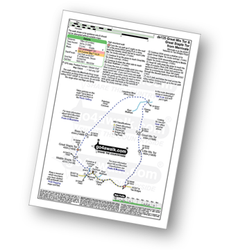
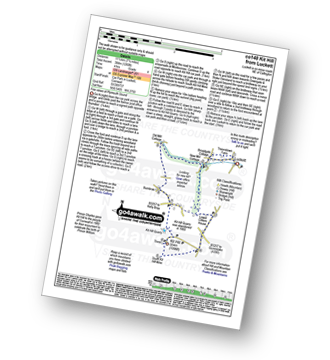
Luckett - Treovitown Farm - New Mill Cottage - Lower Clitters House - South Kit Hill Mine - Kit Hill - Kit Hill Quarry - Downgate - Old Mill Cottage - New Mill Cottage - Luckett
|
Vital Statistics:
| Length: | 8.25 miles (13 km) |
| Ascent: | 1,027 ft (313 m) |
| Time: | 4 hrs |
| Grade: | |
Route Summary:
Two Bridges - Parson's Cottage - Crockern Tor - Littaford Tors - Longaford Tor - Higher White Tor - Lower White Tor - Brown's House - West Dart River - Rough Tor - West Dart River - Cockern Farm - Two Bridges
|
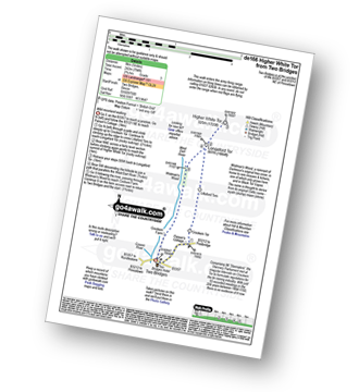
Vital Statistics:
| Length: | 8.25 miles (13 km) |
| Ascent: | 1,201 ft (366 m) |
| Time: | 4.25 hrs |
| Grade: |  |
Route Summary:
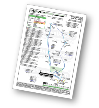
Two Bridges - Beardown Farm - Devonport Leat - Beardown Tors - West Dart River - Mothern Brook - Merrivale Army Firing Range - Devil's Tor - Cowsic River - Two Bridges
|
Vital Statistics:
| Length: | 5 miles (8 km) |
| Ascent: | 794 ft (242 m) |
| Time: | 2.77 hrs |
| Grade: | |
Route Summary:
Two Bridges - Parson's Cottage - Crockern Tor - Littaford Tors - Longaford Tor - Higher White Tor - Wistman's Wood - West Dart River - Two Bridges
|
Vital Statistics:
| Length: | 7.25 miles (11.5 km) |
| Ascent: | 1,247 ft (380 m) |
| Time: | 3.25 hrs |
| Grade: | |
Route Summary:
Dartmeet - East Dart River - Stepping Stones - Walla Brook - Babeny Farm - East Dart River - Stepping Stones - Laughter Hole Farm - Laughter Tor - Dunnabridge Pound - West Dart River - River Swincombe - Hexworthy - Dartmeet
|
Vital Statistics:
| Length: | 4.5 miles (7 km) |
| Ascent: | 870 ft (265 m) |
| Time: | 2½ hrs |
| Grade: | |

Route Summary:
Lanehead - Ger Tor - Willsworthy Army Firing Range - Hare Tor - Rattle Brook - River Tavy - Watern Oke - Tavy Cleave - Mine Leat - Nattor Farm - Lanehead
|
Vital Statistics:
| Length: | 9 miles (14.5 km) |
| Ascent: | 1,398 ft (426 m) |
| Time: | 4.75 hrs |
| Grade: | |

Route Summary:
Lanehead Car Park - Higher Willsworthy - Crouster Farm - Merrivale Army Firing Range - Lynch Tor - Oakhampton Army Firing Range - Fur Tor - Amicombe Brook - Watern Oke - River Tavy - Tavy Cleave - Wilsworthy Army Firing Range - Mine Leat - Nattor Farm - Lanehead Car Park.
|
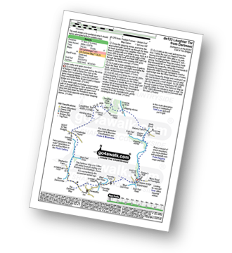
Vital Statistics:
| Length: | 9.75 miles (15.5 km) |
| Ascent: | 1,457 ft (444 m) |
| Time: | 5 hrs |
| Grade: | |

Route Summary:
Postbridge - Bellever Tor - Laughter Tor - Huccaby Tor - Dartmeet - West Dart River - East Dart River - Walla Brook - Bellever - Postbridge
|
Vital Statistics:
| Length: | 5.25 miles (8.5 km) |
| Ascent: | 821 ft (250 m) |
| Time: | 2.75 hrs |
| Grade: | |
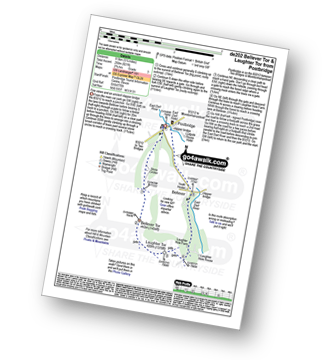
Route Summary:
Postbridge - East Dart River - Bellever Tor - Laughter Tor - Laughter Hole Farm - Bellever - Postbridge
Not familiar with the area around PL6?
See these 30 nearest walks to UK Postcode PL6 on a google map
|
Vital Statistics:
| Length: | 6.25 miles (10 km) |
| Ascent: | 1,122 ft (342 m) |
| Time: | 3½ hrs |
| Grade: | |

Route Summary:
Millpool Car Park - West Looe - East Looe - The South West Coast Path - Hannafore Point - Portnadler Bay - Hore Stone - Talland Bay - Talland Church - Tencreek Campsite - Portlooe - West Looe - East Looe.
|
Vital Statistics:
| Length: | 7.5 miles (12 km) |
| Ascent: | 1,533 ft (467 m) |
| Time: | 4.25 hrs |
| Grade: | |

Route Summary:
Millpool Car Park - West Looe - East Looe - The South West Coast Path - Hannafore Point - Portnadler Bay - Hore Stone - Talland Bay - Talland Church - Tencreek Campsite - Parkers Cross - Kilminorth - Watergate - West Looe River - Kilminorth Wood - West Looe - East Looe.
|
Vital Statistics:
| Length: | 7.25 miles (11.5 km) |
| Ascent: | 1,119 ft (341 m) |
| Time: | 3.75 hrs |
| Grade: | |
Route Summary:
Duloe - Duloe Stone Circle - Gillhill Wood - West Looe River - Tremadart Wood - Churchbridge - Pendruffle Wood - Herodsfoot - Carglonnon Farm - Black Down - Bodbrane Farm - Polvean Cross - Duloe
|
Vital Statistics:
| Length: | 3.75 miles (6 km) |
| Ascent: | 630 ft (192 m) |
| Time: | 2 hrs |
| Grade: | |

Route Summary:
Duloe - Duloe Stone Circle - Gillhill Wood - West Looe River - Tremadart Wood - Churchbridge - Duloe
|
Vital Statistics:
| Length: | 6 miles (9.5 km) |
| Ascent: | 1,076 ft (328 m) |
| Time: | 3.25 hrs |
| Grade: | |
Route Summary:
Pelynt - Outways Farm - Tregarrick Mill - Muchlarnick - Yearle's Wood - West Looe River - Sowden's Bridge - Trelawne Mill - Kiln Wood - Cathrinepark Wood - Pelynt
|
Vital Statistics:
| Length: | 5.5 miles (9 km) |
| Ascent: | 1,407 ft (448 m) |
| Time: | 3½ hrs |
| Grade: | |

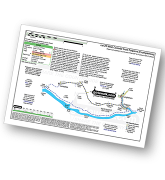
Route Summary:
Crumplehorn - Polperro - Landaviddy Manor - Raphael - Little Lizzen - East Coombe - The South West Coast Path - East Coombe - Broad Cove - Shag Rock - Colours Cove - Chapel Cliff - Polperro - Crumplehorn
|
Vital Statistics:
| Length: | 8 miles (12 km) |
| Ascent: | 1,759 ft (536 m) |
| Time: | 4½ hrs |
| Grade: | |
Route Summary:
Crumplehorn - Polperro - Landaviddy Manor - Raphael - Great Tregue - Lansallos - West Coombe - The South West Coast Path - East Coombe - Broad Cove - Shag Rock - Colours Cove - Chapel Cliff - Polperro - Crumplehorn
|
Vital Statistics:
| Length: | 5.25 miles (8.5 km) |
| Ascent: | 1,260 ft (384 m) |
| Time: | 3.25 hrs |
| Grade: | |

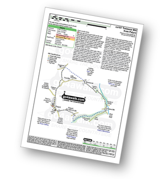
Route Summary:
Crumplehorn - Longcoombe Mill - Watergate House - Sclerder Abbey - Porthallow - Talland Bay - The South West Coast Path - Downend Point - Polperro - Crumplehorn
|
Vital Statistics:
| Length: | 6.25 miles (10 km) |
| Ascent: | 1,132 ft (345 m) |
| Time: | 3½ hrs |
| Grade: | |

Route Summary:
Swallerton Gate - Hound Tor (Bonehill Down) - Hundaford Village - Greator Rocks - Becka Brook - Leighton Farm - Beckaford Bridge - New Bridge - Water - Hayne Cross - Hayne Down - Bowerman's Nose - Swine Down - Jay's Grave - Moorhayes Farm - Swallerton Gate
|
Vital Statistics:
| Length: | 6.5 miles (10.5 km) |
| Ascent: | 1,188 ft (362 m) |
| Time: | 3.75 hrs |
| Grade: | |
Route Summary:
Sourton - Sourton Church - Two Castles Trail - The West Devon Way - Sourton Tors - Vellake Brook - West Okement River - Vellake Weir - Meldon Reservoir - Downside - The Granite Way - Prewley Moor - Sourton Church.
|
Vital Statistics:
| Length: | 8.25 miles (13 km) |
| Ascent: | 1,375 ft (419 m) |
| Time: | 4½ hrs |
| Grade: | |
Route Summary:
Sourton - Sourton Church - River Lyd - Gren Tor - Hunt Tor - Woodcock Hill - Rattle Brook - Kitty Tor (Amicombe Hill) - Amicombe Hill - Sten-a-tor - Corn Ridge - Sourton Tors - Two Castles Trail - The West Devon Way - Prewley Moor - The Granite Way - Sourton Church.
|
Vital Statistics:
| Length: | 9.5 miles (15.5 km) |
| Ascent: | 1,638 ft (499 m) |
| Time: | 5.25 hrs |
| Grade: | |

Route Summary:
Sourton - Sourton Church - River Lyd - Gren Tor - Hunt Tor - Woodcock Hill - Great Links Tor - Higher Dunna Goat - Lower Dunna Goat - Rattle Brook - Green Tor - Kitty Tor (Amicombe Hill) - Amicombe Hill - Steng-a-tor - Corn Ridge - Branscombe Loaf - Sourton Tors - Two Castles Trail - The West Devon Way - Prewley Moor - The Granite Way - Sourton Church.
|
Vital Statistics:
| Length: | 9.5 miles (15 km) |
| Ascent: | 1,687 ft (514 m) |
| Time: | 5 hrs |
| Grade: | |

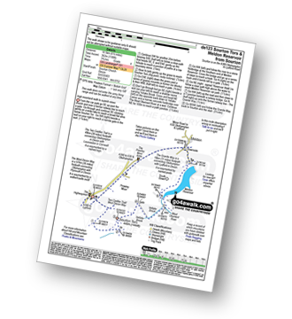
Route Summary:
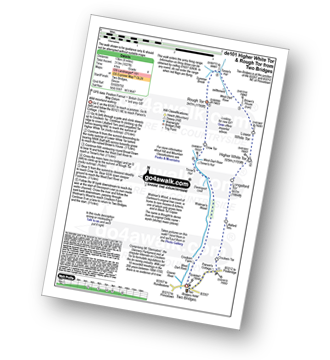
Meldon Reservoir - Longstone Hill - Yes Tor - High Willhays - Dinger Tor - Brim Beck - Kneeset Nose - Sandy Ford - West Okement River - Black-a-Tor Copse - Vellake Weir - Meldon Reservoir
|
Vital Statistics:
| Length: | 6.25 miles (10 km) |
| Ascent: | 1,621 ft (494 m) |
| Time: | 4 hrs |
| Grade: | |
Route Summary:
Meldon Reservoir - Longstone Hill - Okehampton Army Firing Range - Yes Tor - High Willhays - Black Tor - West Okement River - Vellake Weir - Meldon Reservoir
|
Vital Statistics:
| Length: | 2.75 miles (4.5 km) |
| Ascent: | 696 ft (212 m) |
| Time: | 2 hrs |
| Grade: | |

Not familiar with the area around PL6?
See these 30 nearest walks to UK Postcode PL6 on a google map


