UK Postcode PE20 - The 30 nearest easy-to-follow, circular walk route maps to you
The thirty nearest easy-to-follow, circular walk route maps to you in UK Postcode PE20 in Walk Grade Order
The UK cities, towns and villages in Lincolnshire, England that have PE20 in their UK Postcode include:
• Algarkirk • Amber Hill • Bicker • Brothertoft • Drayton • East Heckington • Fenhouses • Fosdyke • Frampton • Frampton West End • Hoffleet Stow • Hubbert's Bridge • Kirton • Kirton End • Kirton Holme • Sandholme • Skeldyke • Sutterton • Swineshead • Swineshead Bridge • Wigtoft •
Not familiar with the area around PE20?
See these 30 nearest walks to UK Postcode PE20 on a google map
   |
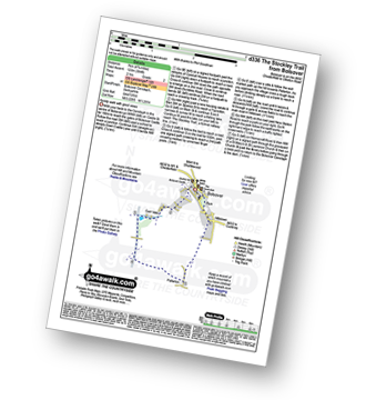
Vital Statistics:
| Length: | 8.75 miles (14 km) |
| Ascent: | 36ft (11m) |
| Time: | 3 hrs |
| Grade: |  |

Route Summary:
Bardney - Bardney Abbey - Young Wood - Southrey Wood - Tupholme Abbey - Southrey - The Viking Way - Bardney
|
Vital Statistics:
| Length: | 7.25 miles (11.5 km) |
| Ascent: | 515ft (157m) |
| Time: | 3 hrs |
| Grade: |  |

|
Vital Statistics:
| Length: | 4.5 miles (7 km) |
| Ascent: | 407ft (124m) |
| Time: | 2 hrs |
| Grade: |  |
Route Summary:
Clumber Park - Clumber Lake - Nursery Wood - Clumber Bridge - South Lawn - Five Thorns Plantation - Boat House Plantation - Tank Wood - Hardwick Grange - Hardwick Village - White Pleasant Wood - Ash Tree Wood - Clumber Park
|
Vital Statistics:
| Length: | 7.5 miles (12 km) |
| Ascent: | 252ft (77m) |
| Time: | 3 hrs |
| Grade: | |
Route Summary:
Cley Beach Car Park - The Marrams - Watch House (Halfway House) - The Hood - Blakeney Point - Lifeboat House - East Bar - Blakeney Point - The Hood - Watch House (Halfway House) - The Marrams - Cley Beach Car Park
|
Vital Statistics:
| Length: | 9 miles (14.5 km) |
| Ascent: | 33ft (10m) |
| Time: | 3½ hrs |
| Grade: | |
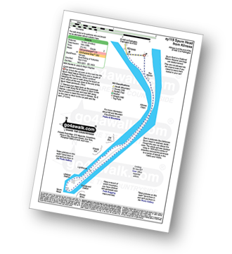
Route Summary:
Kilnsea - Spurn Head Peninsula - The Warren - Kilnsea Clays - Old Den - Greedy Gut - Low Light Lighthouse - Spurn Head - High Light Lighthouse - Stony Binks - Kilnsea
|
Vital Statistics:
| Length: | 4.5 miles (7 km) |
| Ascent: | 295ft (90m) |
| Time: | 2 hrs |
| Grade: | |

Route Summary:
Little Gransden - Waresley - Waresley Wood - Waresley Dean Brook - Gransden Wood - Squirrels' Grove - Gransden Park - Great Gransden - Home Dole Brook - Little Gransden
|
Vital Statistics:
| Length: | 8.5 miles (13.5 km) |
| Ascent: | 246ft (75m) |
| Time: | 3½ hrs |
| Grade: | |
|
Vital Statistics:
| Length: | 6.5 miles (10 km) |
| Ascent: | 82ft (25m) |
| Time: | 2½ hrs |
| Grade: | |

Route Summary:
Fulbourn - Harcamlow Way - Cole's Bridge - New Cut Drain - Hawk Mill Farm - Little Wilbraham - Great Wilbraham - Fleam Dyke - Fulbourn
|
Vital Statistics:
| Length: | 4.75 miles (7 km) |
| Ascent: | 394ft (120m) |
| Time: | 2 hrs |
| Grade: | |
|
Vital Statistics:
| Length: | 6 miles (9.5 km) |
| Ascent: | 331ft (101m) |
| Time: | 2½ hrs |
| Grade: | |
Route Summary:
Thorpe Salvin - Hawks Wood - The Cuckoo Way - Chesterfield Canal - Old Spring Wood - Turnerwood - Crow Wood - Thorpe Salvin
|
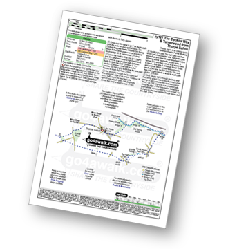
Vital Statistics:
| Length: | 5.5 miles (9 km) |
| Ascent: | 670ft (204m) |
| Time: | 2.75hrs |
| Grade: | |
Route Summary:
Sheringham - The Peddars Way and Norfolk Coast Path - Life Boat Station - Golf Course - Coast Watch Lookout Station - Sheringham Park - Oak Wood - Gazebo View Point - Sheringham Wood - Sheringham Temple - Hall Farm - Upper Sheringham - Sheringham
|
Vital Statistics:
| Length: | 8.25 miles (13 km) |
| Ascent: | 404ft (123m) |
| Time: | 3½ hrs |
| Grade: | |

Route Summary:
Harthill - Woodall - The Cuckoo Way - Kiveton Waters - Chesterfield Canal - Kiveton - Kiveton Park - Hawks Wood - Thorpe Salvin - Loscar Wood - Crow Wood - Harthill
|
Vital Statistics:
| Length: | 10 miles (16 km) |
| Ascent: | 515ft (157m) |
| Time: | 4½ hrs |
| Grade: |  |

Route Summary:
Harthill - Woodall - The Cuckoo Way - Kiveton Waters - Chesterfield Canal - Kiveton - Kiveton Park - Hawks Wood - Old Spring Wood - Turnerwood - Brook House Top Farm - Top Hall Farm - Crow Wood - Harthill
|
Vital Statistics:
| Length: | 6 miles (9.5 km) |
| Ascent: | 322ft (98m) |
| Time: | 2½ hrs |
| Grade: | |
Route Summary:
Felbrigg Hall - Felbrigg Park - Felbrigg Park Church - The Belt - Metton Carrs - Metton - The Weavers Way - Glen Farm Big Fen Plantation - Little Fen Plantation - Sustead Common - Brickfields - Allotment Plantation - Common Plantation - Felbrigg Pond - Roundwood Hill - Fellbrigg Hall.
|
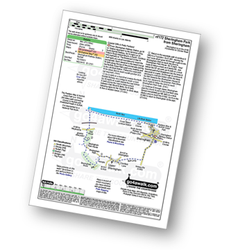
Vital Statistics:
| Length: | 6.5 miles (10 km) |
| Ascent: | 328ft (100m) |
| Time: | 2½ hrs |
| Grade: | |

Route Summary:
Turvey - Turvey Abbey - Priory Farm - Grotto Plantation - Hill Spinney - Ramacre Wood - Gorewell - The Milton Keynes Boundary Walk - Gullet Wood - Keepers (Church's) Cottage - Woodside - Turvey
Not familiar with the area around PE20?
See these 30 nearest walks to UK Postcode PE20 on a google map
|
Vital Statistics:
| Length: | 5.25 miles (8.5 km) |
| Ascent: | 292ft (89m) |
| Time: | 2.25hrs |
| Grade: | |
|
Vital Statistics:
| Length: | 6.5 miles (10.5 km) |
| Ascent: | 338ft (103m) |
| Time: | 2.75hrs |
| Grade: | |
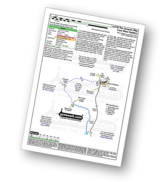
Route Summary:
West Haddon - Foxhill Farm - Watford - The Jurassic Way - Barleypiece Spinney - Long Spinney - Flavell's Lodge - Silsworth Lodge Farm - West Haddon
|
Vital Statistics:
| Length: | 5 miles (8 km) |
| Ascent: | 345ft (105m) |
| Time: | 2.25hrs |
| Grade: | |
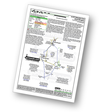
Route Summary:
Great Brington - Nobottle Wood - The Midshires Way - Nobottle - The Macmillan Way - Little Brington - Great Brington
|
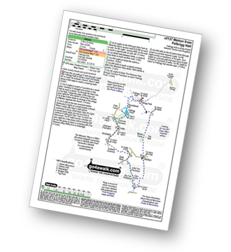
Vital Statistics:
| Length: | 5.75 miles (9 km) |
| Ascent: | 226ft (69m) |
| Time: | 2½ hrs |
| Grade: | |

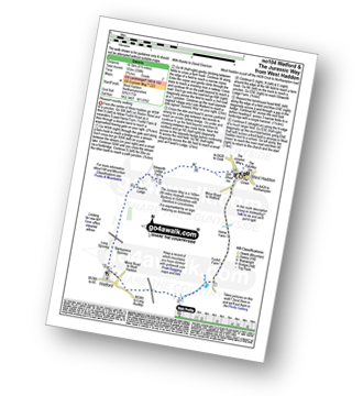
Route Summary:
Watford - The Jurassic Way - Barleypiece Spinney - Long Spinney - Watford Covert - Flavell's Lodge - Silsworth Lodge Farm - Cherry Lodge - Watford
|
Vital Statistics:
| Length: | 3.5 miles (5.5 km) |
| Ascent: | 289ft (88m) |
| Time: | 1.75hrs |
| Grade: | |

Route Summary:
Conkers Discovery Centre - Swadlincote - Conkers Waterside - Ashby Woulds Heritage Trail - Donisthorpe - Donisthorpe Woodland Park - Ashby De La Zouch Canal - Moira Lock - Moira Furnace Museum - Moira - Sarah's Wood - Conkers Waterside - Conkers Discovery Centre - Swadlincote.
|
Vital Statistics:
| Length: | 3.5 miles (5.5 km) |
| Ascent: | 98ft (30m) |
| Time: | 1½ hrs |
| Grade: | |
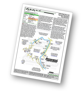
Route Summary:
- Norwich (The Forum) - The River Wensum - Fye Bridge - Cow Tower - Bishop's Bridge - Pulls Ferry - The Compleat Angler - Foundry Bridge - Millennium Bridge - Lady Julian Bridge - Carrow Bridge - The Devil's Tower (Eastern Boom Tower) - King Street - Wensum Lodge (a.k.a. The Music House) - Dragon Hall - St Peter of Parmentergate church - St Julian's Church - Novi Sad Friendship Bridge - Timber Hills - The Gardeners Arms (a.k.a. The Murderers) - The Lamb - St Peter Mancroft Church - The Guildhall - Norwich (The Forum)
|
Vital Statistics:
| Length: | 4.25 miles (6.5 km) |
| Ascent: | 157ft (2,348m) |
| Time: | 1.75hrs |
| Grade: | |

Route Summary:
Worstead - Worstead Belt - Worstead Hall Farm - Chestnut Belt - Gothic Wood - Upper Street - Carman's Lane - Mucklefield Plantation - Dairyhouse Barn - Green Lane - Berard's Road - Worstead
|
Vital Statistics:
| Length: | 4 miles (6.5 km) |
| Ascent: | 400ft (122m) |
| Time: | 2 hrs |
| Grade: | |

Route Summary:
Hell Bank Plantation - Beeley Plantation - Rabbit Warren - Beeley Brook - Hob Hurst's House - Harland Edge - Beeley Moor - Beeley Moor (South East Top) - Beeley Lane - Harland Sick - Hell Bank Plantation
|
Vital Statistics:
| Length: | 12.75 miles (20.5 km) |
| Ascent: | 1,956ft (596m) |
| Time: | 6.75hrs |
| Grade: |  |
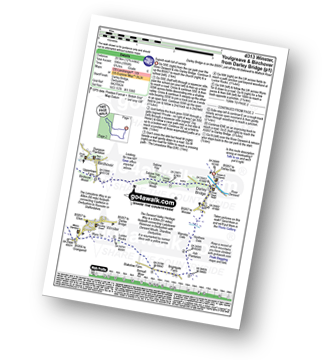
Route Summary:
Darley Bridge - Wensley Dale - Northern Dale - Ash Plantation - Brightgate Farm - Bonsall Moor - The Limestone Way - Luntor Rocks - Winster - Westhill Farm - Robin Hood's Stride - Harthill Moor - Harthill Moor Wood - Bleakley Dike - River Bradford - Bradford Dale - Youlgreave - Rhienstor Plantation - Greenfield Farm - Stoney Ley Wood - Rocking Stone Farm - Birchover - Uppertown Farm - Clough Wood - Sabine Hey Wood - Cowley Knowl - Darley Bridge
|
Vital Statistics:
| Length: | 8.25 miles (13 km) |
| Ascent: | 843ft (257m) |
| Time: | 3.75hrs |
| Grade: | |

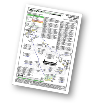
Route Summary:
Carsington Water Visitors Centre - Carsington Water Dam - Millfields - 'Wooden' House - Upperfield Farm - Hopton - Hopton Hall - Carsington - Sheepwash - Carsington Wildlife Conservation Centre - Carsington Water Visitors Centre
|
Vital Statistics:
| Length: | 6.25 miles (10 km) |
| Ascent: | 1,103ft (336m) |
| Time: | 3½ hrs |
| Grade: | |

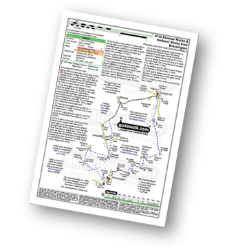
Route Summary:
Birchen Edge Car Park - Jumble Coppice - Three Men - Cupola Cottage - Jack Flat - Wellington's Monument - Curbar Gap - Baslow Edge - Eagle Stone - Eaglestone Flat - Birchen Edge - Nelson's Monument (Birchen Edge) - Three Ships - Birchen Edge Car Park
|
Vital Statistics:
| Length: | 8.25 miles (13 km) |
| Ascent: | 1,122ft (342m) |
| Time: | 4.25hrs |
| Grade: | |

Route Summary:
Beeley - Moor Farm - Beeley Plantation - Rabbit Warren - Beeley Brook - Hob Hurst's House - Harland Edge - Beeley Moor - Beeley Moor (South East Top) - Beeley Lane - Harland Sick - Hell Bank Plantation - Fallinge Farm - Smeltingmill Wood - Fold Farm - Beeley
|
Vital Statistics:
| Length: | 6.5 miles (10.5 km) |
| Ascent: | 1,115ft (340m) |
| Time: | 3½ hrs |
| Grade: | |
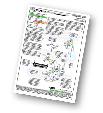
Route Summary:
Rowsley - Holly Wood - Stanton Woodhouse Farm - Stanton Moor - The Reform Tower (or Earl Grey Tower) - The Cork Stone - Nine Ladies Stone Circle - Stanton in Peak - Smithy Wood - Congreave Farm - Rowsley
|
Vital Statistics:
| Length: | 7.25 miles (11.5 km) |
| Ascent: | 1,080ft (329m) |
| Time: | 3.75hrs |
| Grade: | |
Route Summary:
Brassington - The Limestone Way - Rainster Rocks - Longcliffe - Aldwark - Grangemill - The Limestone Way - Grange Mill Quarry - Harboro' Farm - Harboro' Rocks - Bee Nest Mine - Brassington
|
Vital Statistics:
| Length: | 8.25 miles (13 km) |
| Ascent: | 1,358ft (414m) |
| Time: | 4½ hrs |
| Grade: |  |
Route Summary:
Winster - Luntor Rocks - The Limestone Way - Blakelow Hill - Bonsall Moor - Upper Town - Bonsall - Slaley - Dunsley Springs - Bonsall Wood - Ible Wood - Whitelow Farm - Bonsall Moor - Wyns Tor - Winster
Not familiar with the area around PE20?
See these 30 nearest walks to UK Postcode PE20 on a google map


