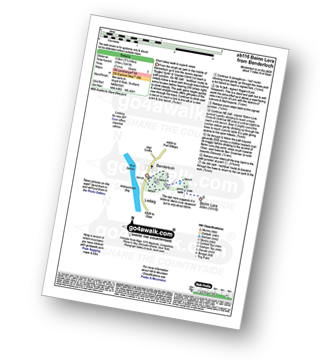
UK Postcode PA21 - The 30 nearest easy-to-follow, circular walk route maps to you
The thirty nearest easy-to-follow, circular walk route maps to you in UK Postcode PA21 in Walk Grade Order
The UK cities, towns and villages in Argyll and Bute, Scotland that have PA21 in their UK Postcode include:
• Acharosson • Ardlamont • Auchenlochan • Auchnaha • Ballimore • Blair's Ferry • Carry • Craignafeich • Derybruich • Drum • Fearnoch • Kames • Kilfinan • Largiemore • Lindsaig • Lower Auchalick • Melldalloch • Millhouse • Otter • Otter Ferry • Port Driseach • Portavadie • Tighnabruaich • West Glen •
Not familiar with the area around PA21?
See these 30 nearest walks to UK Postcode PA21 on a google map
   |
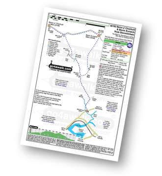
Vital Statistics:
| Length: | 8.75 miles (14 km) |
| Ascent: | 3,499ft (1,051m) |
| Time: | 6.75hrs |
| Grade: |  |

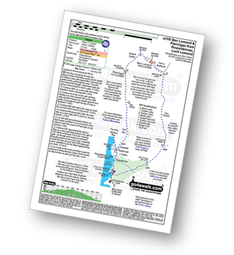
Route Summary:
Arrochar - Loch Long - Ardgarten Forest - Allt a' Bhalachain - Narnain Boulders - Core a' Bhalachain - Lochan a' Chlaidheimh - Bealach A Mhaim - Beinn Ime - Bealach A Mhaim - Lochan a' Chlaidheimh - Core a' Bhalachain - Narnain Boulders - Allt a' Bhalachain - Ardgarten Forest - Arrochar
|
Vital Statistics:
| Length: | 6 miles (9.5 km) |
| Ascent: | 3,216ft (980m) |
| Time: | 5½ hrs |
| Grade: |  |

Route Summary:
Arrochar - Loch Long - Argyle Forest - Creag An Fhithich - Cruach Nam Miseag - The Spearhead - Beinn Narnain - Yawning Crags - Bealach A Mhaim - Lochan a' Chlaidheimh - Core a' Bhalachain - Narnain Boulders - Allt a' Bhalachain - Andgarten Forest - Loch Long - Arrochar
|
Vital Statistics:
| Length: | 7.5 miles (11.5 km) |
| Ascent: | 3,344ft (1,019m) |
| Time: | 6 hrs |
| Grade: | |

Route Summary:
Arrochar - Loch Long - Argyll Forest Park - Adgarten Forest - Allt a' Bhalachain - Narnain Boulders - The Cobbler (Ben Arthur) (NE Top) - The Cobbler (Ben Arthur) - Lochan a' Chlaidheimh - Coire a' Bhalachain - Narnain Boulders - Allt a' Bhalachain - Adgarten Forest - Argyll Forest Park - Arrochar - Loch Long.
|
Vital Statistics:
| Length: | 7.75 miles (12.5 km) |
| Ascent: | 3,180ft (969m) |
| Time: | 6 hrs |
| Grade: | |

Route Summary:
Rowardennan - Loch Lomond - Sron Aonaich - Ben Lomond - Sron Aonaich - The West Highland Way - Rowardennen - Loch Lomond.
|
Vital Statistics:
| Length: | 7.5 miles (12 km) |
| Ascent: | 3,426ft (1,044m) |
| Time: | 6.25hrs |
| Grade: | |
Route Summary:
Rowardennan - Loch Lomond - Sron Aonaich - Ben Lomond - Ptarmigan - Tom Fithich - The West Highland Way - Rowardennen - Loch Lomond.
|
Vital Statistics:
| Length: | 6.25 miles (10 km) |
| Ascent: | 4,506ft (459m) |
| Time: | 4 hrs |
| Grade: |  |
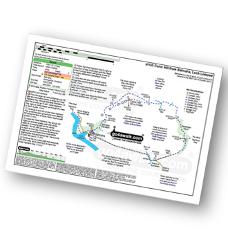
Route Summary:
Balmaha - The West Highland Way - Conic Hill - Burn of Mar - Garadhban Wood - Creity Hall - Milton of Buchanan - Balmaha
|
Vital Statistics:
| Length: | 9 miles (14.5 km) |
| Ascent: | 3,502ft (1,067m) |
| Time: | 6.75hrs |
| Grade: | |

Route Summary:
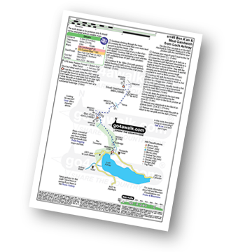
Inveruglas Power Station - Loch Lomond - A82 - Inveruglas Water - Loch Sloy Access Road - Lag Dubh - Ben Vorlich (The Arrochar Alps) - Ben Vorlich (The Arrochar Alps) (North Top) - Lag Dubh - Loch Sloy Access Road - Inveruglas - Loch Lomond.
|
Vital Statistics:
| Length: | 7.5 miles (12 km) |
| Ascent: | 3,101ft (945m) |
| Time: | 6 hrs |
| Grade: | |
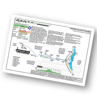
Route Summary:
Inveruglas Power Station - Loch Lomond - Loch Sloy Hydro Electric Sub-station - Inveruglas Water - Coiregrogain - Ben Vane - Coiregrogain - Inveruglas Water - Loch Sloy Hydro Electric Sub-station - Inveruglas Power Station - Loch Lomond.
|
Vital Statistics:
| Length: | 1.5 miles (2.5 km) |
| Ascent: | 542ft (165m) |
| Time: | 1.25hrs |
| Grade: |  |

Route Summary:
Inversnaid - Inversnaid Hotel - Arklet Falls - Loch Lomond - The West Highland Way - Leacainn Lasgair - Cladachbeag - Inversnaid Hotel - Inversnaid
|
Vital Statistics:
| Length: | 2.75 miles (4.5 km) |
| Ascent: | 627ft (191m) |
| Time: | 1.75hrs |
| Grade: |  |

|
Vital Statistics:
| Length: | 11.5 miles (18.5 km) |
| Ascent: | 7,020ft (2,139m) |
| Time: | 11½ hrs |
| Grade: |  |

Route Summary:
Falls of Cruachan - Loch Awe - Cruachan Reservoir - Coire Dearg - Meall Cuanail - Stob Dearg (Taynuilt Peak) - Ben Cruachan - Coire Caorach - Drochaid Ghlas (Ben Cruachan) - Stob Diamh - Stob Garbh (Stob Diamh) - Lairig Torran - Beinn a' Bhuiridh - Cruachan Reservoir - Falls of Cruachan
|
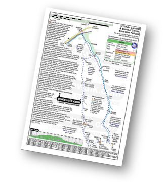
Vital Statistics:
| Length: | 7 miles (11 km) |
| Ascent: | 2,534ft (772m) |
| Time: | 5 hrs |
| Grade: | |
|
Vital Statistics:
| Length: | 1.5 miles (2.5 km) |
| Ascent: | 20ft (6m) |
| Time: | 1 hrs |
| Grade: | |

|
Vital Statistics:
| Length: | 8.5 miles (13.5 km) |
| Ascent: | 4,378ft (1,334m) |
| Time: | 7½ hrs |
| Grade: | |
Route Summary:
B8077 - Allt Mhoille - Castles Farm - Allt Lairig Lanachan - Glen Noe - Beinn a' Chochuill - Beinn Eunaich - Stob Maol - Castles Farm - B8077
|
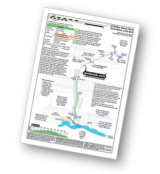
Vital Statistics:
| Length: | 7.25 miles (11.5 km) |
| Ascent: | 1,175ft (358m) |
| Time: | 3.75hrs |
| Grade: |  |
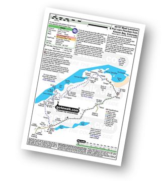
Route Summary:
Kiloran Bay - Druim Buidhe - Upper Kilchattan - Colnatarun Cottage and Bike Hire - Gortain - Leana Mor - Binnein Riabhach (Colonsay) - Aoineadh an t-Sruth - Lamalum - Leum a' Bhriair - Meall Lamalum - An Caigionn - Beinn Bhreac (Colonsay) - Creag Nan Ubhal - Port Nam Fliuchan - Cailleach Uragaig - Duntealtaig - Dun Tealtaig - Uragaig - Creagan - Kiloran Bay
Not familiar with the area around PA21?
See these 30 nearest walks to UK Postcode PA21 on a google map
|
Vital Statistics:
| Length: | 2.5 miles (4 km) |
| Ascent: | 1,329ft (405m) |
| Time: | 2½ hrs |
| Grade: |  |

Route Summary:
Ben A'an Forestry Commision Car Park - Loch Achray - The Trossachs - Woodland - Ben A'an - Woodland - Ben A'an Forestry Commision Car Park - Loch Achray.
|
Vital Statistics:
| Length: | 5.25 miles (8.5 km) |
| Ascent: | 2,117ft (645m) |
| Time: | 4 hrs |
| Grade: | |
Route Summary:
Ben A'an Forestry Commision Car Park - Loch Achray - The Trossachs - Woodland - Ben A'an - Meall Gainmheich - Ben A'an Forestry Commision Car Park - Loch Achray.
|
Vital Statistics:
| Length: | 9.5 miles (15 km) |
| Ascent: | 3,673ft (1,119m) |
| Time: | 7.25hrs |
| Grade: | |
Route Summary:
Glen Falloch - River Falloch - Sron Garbh - Coire Elch - Twistin Hill - The Castle - An Caisteal (Glen Falloch) - Bealach Buidhe - Beinn a' Chroin - Beinn a' Chroin (East Top) - River Falloch - Core Earb - Glen Falloch
|
Vital Statistics:
| Length: | 4.5 miles (7 km) |
| Ascent: | 1,241ft (378m) |
| Time: | 3 hrs |
| Grade: | |
|
Vital Statistics:
| Length: | 6.25 miles (9.5 km) |
| Ascent: | 2,681ft (817m) |
| Time: | 5 hrs |
| Grade: | |

Route Summary:
Falls of Leny - Car Park NW of Falls of Leny - The Rob Roy Way - Garbh Uisge - Coireachchrombie - Stank - Stank Glen - Bealach Nan Corp - Coire na Fuaire - Gualainn Buidhe - Mullach Buidhem - Ben Ledi - Meal Odher - Creag Ghornm Car Park - Falls of Leny
|
Vital Statistics:
| Length: | 6.25 miles (10 km) |
| Ascent: | 1,848ft (563m) |
| Time: | 4.25hrs |
| Grade: | |

Route Summary:
Strathyre - River Balvag - Strathyre Forest - An Sidhean - Beinn an t-Sidhein - Beinn Luidh - Buachaille Breige - Stroneslaney - Baileful - Strathyre
|
Vital Statistics:
| Length: | 5.25 miles (8.5 km) |
| Ascent: | 1,165ft (355m) |
| Time: | 3½ hrs |
| Grade: | |
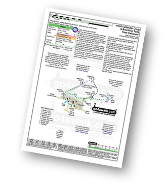
Route Summary:
Callander - Callander Craig - Bracklinn Falls Car Park - Keltie Water - Bracklinn Falls - Woodland - Callander
|
Vital Statistics:
| Length: | 13.75 miles (22 km) |
| Ascent: | 4,523ft (1,378m) |
| Time: | 9½ hrs |
| Grade: | |

Route Summary:
Victoria Bridge - Forest Lodge - Abhainn Shira - Clashgour Estate - Clashgour Hut - Caolain Dubh - Stob a' Choire Odhair (Black Mount) - Aoneach Eagach - Core na Muic - Stob Maol - Stob Ghabhar - Core Chaolain - Core Ghabhar - Sron a';Ghearrain (Stob Ghabhar) - Bealach Core Laoghan - Stob a' Bhruaich Leith (Stob Ghabhar) - Bealach Core Laoghan - Lurg Bhan - Alt Ghabhar - Clashgour - Abhainn Shira - Clashgour Hut - Forest Lodge - Victoria Bridge
|
Vital Statistics:
| Length: | 12.25 miles (19.5 km) |
| Ascent: | 4,322ft (1,317m) |
| Time: | 8.75hrs |
| Grade: |  |

Route Summary:
A82 - Lochan na Stainge - Ba Cottage - Sron Nam Forsair - Clach Leathad (Creise) - Mam Coire Easain (Creise) - Creise - Stob a' Ghlais Choire (Creise) - Meall a' Bhuiridh - Ba Cottage - Lochan na Stainge - A82
|
Vital Statistics:
| Length: | 2.75 miles (4.5 km) |
| Ascent: | 82ft (25m) |
| Time: | 1 hrs |
| Grade: | |

|
Vital Statistics:
| Length: | 5 miles (8 km) |
| Ascent: | 2,983ft (909m) |
| Time: | 5 hrs |
| Grade: | |

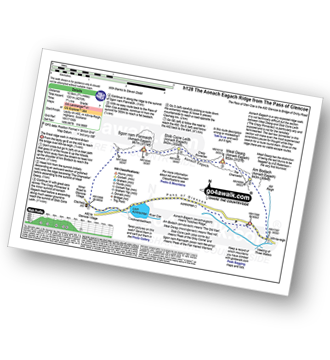
Route Summary:
The Pass of Glencoe - Mam Buidhe - Stob Coire Raineach (Buachaille Etive Beag) - Buachaille Etive Beag (Stob Dubh) - Lairig Eilde - The Pass of Glencoe
|
Vital Statistics:
| Length: | 6.5 miles (10.5 km) |
| Ascent: | 3,318ft (1,011m) |
| Time: | 6 hrs |
| Grade: | |

Route Summary:
The Pass of Glencoe - Mam Buidhe - Stob Coire Raineach (Buachaille Etive Beag) - Buachaille Etive Beag (Stob Dubh) - Lairig Eilde - The Pass of Glencoe
|
Vital Statistics:
| Length: | 9.25 miles (14.5 km) |
| Ascent: | 2,194ft (669m) |
| Time: | 5½ hrs |
| Grade: | |

|
Vital Statistics:
| Length: | 7.75 miles (12.5 km) |
| Ascent: | 4,270ft (1,301m) |
| Time: | 7.25hrs |
| Grade: | |
Route Summary:
The Pass of Glencoe - Allt-na-Reigh - Am Bodach (Aonach Eagach) - The Chancellor - Meall Dearg (Aonach Eagach) - Aonach Eagach Ridge - Stob Coire Leith (Aonach Eagach) - Sgorr Nam Fiannaidh (Aonach Eagach) - Clachaig Gully - Clachaig Inn - Loch Achtriochtan - The Pass of Glencoe
|
Vital Statistics:
| Length: | 9.5 miles (15 km) |
| Ascent: | 6,173ft (1,881m) |
| Time: | 10 hrs |
| Grade: | |

Route Summary:
The Pass of Glencoe - The River Coe - Coire Nan Lochan - Stob Coire Nan Lochan (Bidean Nam Bian) - Bidean Nam Bian - Stob Coire Nam Beith (Bidean Nam Bian) - Bidean Nam Bian - Lost Valley Buttress - Bealach Dearg - Stob Coire Sgreamhach - Beinn Fhada (Stob Coire Sgreamhach) - Beinn Fhada (Stob Coire Sgreamhach) (North East Top) - Beinn Fhada (Stob Coire Sgreamhach) - Stob Coire Sgreamhach - Bealach Dearg - Coire Gabhail (The 'Lost Valley') - Allt Corrie Gabhail - The Pass of Glencoe
Not familiar with the area around PA21?
See these 30 nearest walks to UK Postcode PA21 on a google map


