UK Postcode DN16 - The 30 nearest easy-to-follow, circular walk route maps to you
The thirty nearest easy-to-follow, circular walk route maps to you in UK Postcode DN16 in Walk Grade Order
The UK cities, towns and villages in Lincolnshire, England that have DN16 in their UK Postcode include:
• Ashby • Bottesford •
Not familiar with the area around DN16?
See these 30 nearest walks to UK Postcode DN16 on a google map
   |
Vital Statistics:
| Length: | 4.5 miles (7 km) |
| Ascent: | 407 ft (124 m) |
| Time: | 2 hrs |
| Grade: |  |
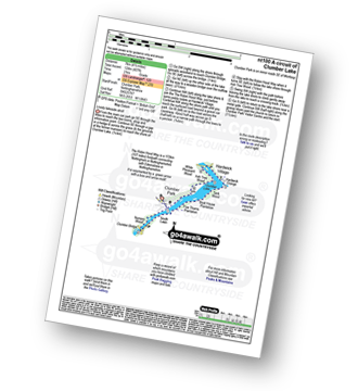
Route Summary:
Clumber Park - Clumber Lake - Nursery Wood - Clumber Bridge - South Lawn - Five Thorns Plantation - Boat House Plantation - Tank Wood - Hardwick Grange - Hardwick Village - White Pleasant Wood - Ash Tree Wood - Clumber Park
|
Vital Statistics:
| Length: | 8.75 miles (14 km) |
| Ascent: | 36 ft (11 m) |
| Time: | 3 hrs |
| Grade: |  |

Route Summary:
Bardney - Bardney Abbey - Young Wood - Southrey Wood - Tupholme Abbey - Southrey - The Viking Way - Bardney
|
Vital Statistics:
| Length: | 6 miles (9.5 km) |
| Ascent: | 331 ft (101 m) |
| Time: | 2½ hrs |
| Grade: | |
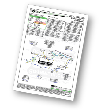
Route Summary:
Thorpe Salvin - Hawks Wood - The Cuckoo Way - Chesterfield Canal - Old Spring Wood - Turnerwood - Crow Wood - Thorpe Salvin
|
Vital Statistics:
| Length: | 8.25 miles (13 km) |
| Ascent: | 404 ft (123 m) |
| Time: | 3½ hrs |
| Grade: |  |

Route Summary:
Harthill - Woodall - The Cuckoo Way - Kiveton Waters - Chesterfield Canal - Kiveton - Kiveton Park - Hawks Wood - Thorpe Salvin - Loscar Wood - Crow Wood - Harthill
|
Vital Statistics:
| Length: | 10 miles (16 km) |
| Ascent: | 515 ft (157 m) |
| Time: | 4½ hrs |
| Grade: |  |

Route Summary:
Harthill - Woodall - The Cuckoo Way - Kiveton Waters - Chesterfield Canal - Kiveton - Kiveton Park - Hawks Wood - Old Spring Wood - Turnerwood - Brook House Top Farm - Top Hall Farm - Crow Wood - Harthill
|
Vital Statistics:
| Length: | 9 miles (14.5 km) |
| Ascent: | 33 ft (10 m) |
| Time: | 3½ hrs |
| Grade: | |
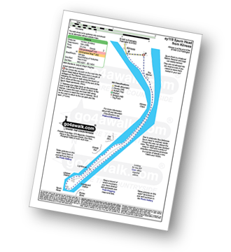
Route Summary:
Kilnsea - Spurn Head Peninsula - The Warren - Kilnsea Clays - Old Den - Greedy Gut - Low Light Lighthouse - Spurn Head - High Light Lighthouse - Stony Binks - Kilnsea
|
Vital Statistics:
| Length: | 4.75 miles (7 km) |
| Ascent: | 394 ft (120 m) |
| Time: | 2 hrs |
| Grade: | |
|
Vital Statistics:
| Length: | 6.75 miles (11 km) |
| Ascent: | 696 ft (212 m) |
| Time: | 3.25 hrs |
| Grade: | |
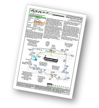
Route Summary:
Cote Hill - The Leeds Country Walk - Harewood Gardens - Lodge Hills - Nan Pie - Grey Stone Pasture - New Bridge - Piper Wood - Stub House Plantation - The Ebor Way - Carr House - Carr Wood - Stank - Harewood House - Home Farm - The Grove - Harewood - Maltkin House - New Laithe Farm - Cut Whin Wood - Hollin Hall - Hollin Hall Pnds - Wike Wood - Cote Hill
|
Vital Statistics:
| Length: | 4.5 miles (7 km) |
| Ascent: | 804 ft (245 m) |
| Time: | 2½ hrs |
| Grade: | |
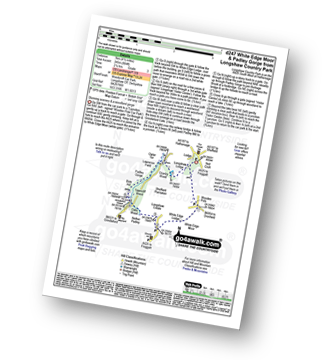
Route Summary:
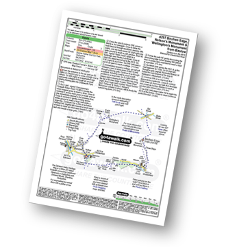
Longshaw Country Park - Woodcroft Car Park - Wooden Pool - White Edge Moor - White Edge Lodge - Nether Padley - Oaks Wood - Grindleford Station - Padley Gorge - Lawrence Field - Burbage Brook - Granby Barn - Granby Wood - Longshaw Pond - Longshaw Country Park
|
Vital Statistics:
| Length: | 5.5 miles (8.5 km) |
| Ascent: | 1,007 ft (307 m) |
| Time: | 3 hrs |
| Grade: | |
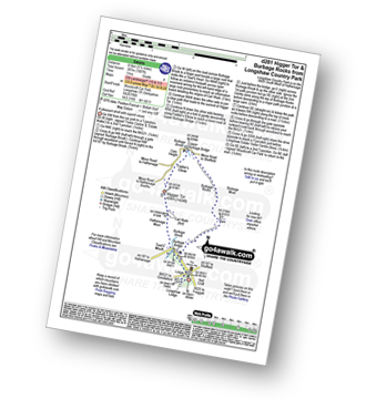
Route Summary:
Longshaw Country Park - Woodcroft Car Park - Burbage Brook - Burbage Bridge - Toad's Mouth - Hathersage Moor - Carl Wark - Higger Tor - Upper Burbage Bridge - Burbage Moor - Burbage Rocks - Longshaw Country Park
|
Vital Statistics:
| Length: | 8.5 miles (13.5 km) |
| Ascent: | 896 ft (273 m) |
| Time: | 4 hrs |
| Grade: | |

Route Summary:
Longshaw Country Park - Woodcroft Car Park - Wooden Pole - White Edge Moor - White Edge (Big Moor) - White Edge (Big Moor) (South East Top) - Curbar Gap - Curbar Edge - Froggatt Edge - Hay Wood - Longshaw Estate - Sheffield Plantation - Longshaw Lodge - Longshaw Country Park
|
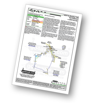
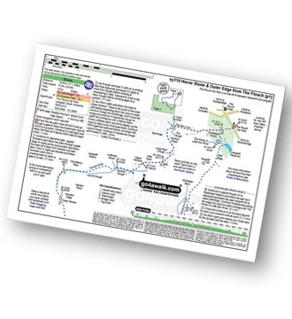
Vital Statistics:
| Length: | 3.75 miles (6.5 km) |
| Ascent: | 673 ft (205 m) |
| Time: | 2.25 hrs |
| Grade: | |
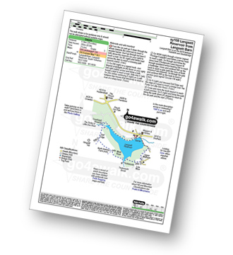
Route Summary:
Langsett Barn - Langsett - Langsett Reservoir Dam - Upper Midhope - Thickwoods - Thickwoods Brook - North America Farm - Delf Edge - Langsett Reservoir - The Porter or Little Don River - Crookland Wood - Langsett Reservoir - Langsett Barn
|
Vital Statistics:
| Length: | 7.5 miles (12 km) |
| Ascent: | 1,118 ft (360 m) |
| Time: | 4 hrs |
| Grade: | |

Route Summary:
Langsett Barn - Langsett - Langsett Reservoir - Langsett Reservoir Dam - Upper Midhope - Thickwoods - Thickwoods Brook - Fenny Common Ings - Fenny Common - Pike Lowe Stones - Pike Lowe - Candlerush Edge - Sugden Top - Lost Lad (Langsett) - Mickleden Edge (Langsett) - Haslingshaw Hingcliff Common - Delf Edge - Langsett Reservoir - The Porter or Little Don River - Crookland Wood - Langsett Reservoir - Langsett Barn
|
Vital Statistics:
| Length: | 7.75 miles (12.5 km) |
| Ascent: | 1,598 ft (487 m) |
| Time: | 4½ hrs |
| Grade: |  |

Route Summary:
South Landing - West Nook - RNLI Lifeboat Station - East Nook - Great Scars - South Cliff - Two Stones - Cattlemere Scar - High Stacks - Cough Hole - Flamborough Head - Selwicks Bay - Cradle Head - Breil Nook - Carter Lane - East Scar - North Landing - High Holme - Thornwick Bay - North Cliff - Close Nook - Flamborough - South Landing
|
Vital Statistics:
| Length: | 5 miles (8 km) |
| Ascent: | 683 ft (208 m) |
| Time: | 2½ hrs |
| Grade: | |
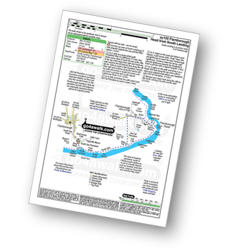
Route Summary:
South Landing - West Nook - RNLI Lifeboat Station - East Nook - Great Scars - South Cliff - Two Stones - New Fall - Old Fall Plantation - Flamborough Head - Cough Hole - High Stacks - Cattlemere Scar - South Cliff - South Landing
Not familiar with the area around DN16?
See these 30 nearest walks to UK Postcode DN16 on a google map
|
Vital Statistics:
| Length: | 11.5 miles (18.5 km) |
| Ascent: | 1,674 ft (510 m) |
| Time: | 6 hrs |
| Grade: |  |
Route Summary:
The Flouch Car Park - Crookland Wood - Swinden Lane - Fox Clough - Langsett Moors - Barmings - Hordron Road - Long Moor Clough - Hordron Clough - The Porter or Little Don River - Laund Clough - Harden Moor - Howden Edge - Hoar Stones - Horse Stone (Horse Stone Naze) - Stainery Clough Head - Howden Moors - Crow Stones - Crow Stones Edge - Outer Edge - Cut Gate End - Cut Gate Path - Mickleden Edge - Delf Edge - Langsett Reservoir - The Porter or Little Don River - The Flouch.
|
Vital Statistics:
| Length: | 10.75 miles (17 km) |
| Ascent: | 1,493 ft (455 m) |
| Time: | 5½ hrs |
| Grade: | |

Route Summary:
Grindleford Station - Oaks Wood - Nether Padley - White Edge Moor - Hurkling Stone - White Edge - White Edge (Big Moor) - White Edge (Big Moor) (South East Top) - Curbar Gap - Baslow Edge - Eaglestone Flat - Eagle Stone - Wellington's Monument - Over End - Baslow - The Derwent Valley Heritage Way - Bridge End - River Derwent - Bubnell - Townend Wood - St Mary's Wood - Curbar - Stocking Farm - New Bridge - Froggatt Bridge - Derwent Farm - Horse Hay Coppice - Grindleford - Grindleford Station
|
Vital Statistics:
| Length: | 7.5 miles (12 km) |
| Ascent: | 1,467 ft (447 m) |
| Time: | 4.25 hrs |
| Grade: | |

Route Summary:
Grindleford Station - Padley Gorge - Lawrence Field - Toad's Mouth - Hathersage Moor - Carl Wark - Higger Tor - Fiddler's Elbow - Upper Burbage Bridge - Burbage Moor - Burbage Rocks - Longshaw Country Park - Sheffield Plantation - Nether Padley - Oaks Wood - Grindleford Station
|
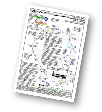
Vital Statistics:
| Length: | 6.75 miles (11 km) |
| Ascent: | 1,122 ft (342 m) |
| Time: | 3.75 hrs |
| Grade: | |

Route Summary:
Hay Wood - Longshaw - Froggatt Edge - Curbar Edge - Curbar - The Derwent Valley Heritage Way - The River Derwent - Stocking Farm - The Goit - New Bridge - Stoke Brook - Froggatt Bridge - Derwent Farm - Horse Hay Coppice - Grindleford - Grindleford Church - Hay Wood
|
Vital Statistics:
| Length: | 6.25 miles (10 km) |
| Ascent: | 1,103 ft (336 m) |
| Time: | 3½ hrs |
| Grade: | |

Route Summary:
Birchen Edge Car Park - Jumble Coppice - Three Men - Cupola Cottage - Jack Flat - Wellington's Monument - Curbar Gap - Baslow Edge - Eagle Stone - Eaglestone Flat - Birchen Edge - Nelson's Monument (Birchen Edge) - Three Ships - Birchen Edge Car Park
|
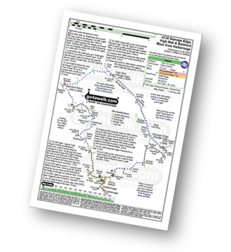
Vital Statistics:
| Length: | 9.75 miles (15.5 km) |
| Ascent: | 1,001 ft (305 m) |
| Time: | 4.75 hrs |
| Grade: | |
Route Summary:
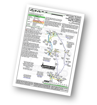
Curbar Gap - Curbar Edge - Froggatt Edge - Hay Wood - Longshaw (A621) - White Edge Lodge - White Edge Moor - Barbrook Bridge - Barbrook Reservoir - Bar Brook - Big Moor - Ramsley Moor - Ramsley Reservoir - Blake Brook - Wellington's Monument - Eagle Stone - Eaglestone Flat - Baslow Edge - Curbar Gap
|
Vital Statistics:
| Length: | 9.5 miles (15 km) |
| Ascent: | 2,097 ft (639 m) |
| Time: | 5½ hrs |
| Grade: | |
Route Summary:
Hathersage - Hathersage Pinfold - Toothill Farm - Hookcar Sitch - Overstones Farm - Cowper Stone - Stanage Edge (Stanage Edge) - Hook's Car - White Path Moss - Robin Hood's Cave - Stanage Plantation - Long Causeway - Stanage Edge - High Neb (Stanage Edge) - Crow Chin - Moscar Moor - Bamford Moor - Upper Hurst Brook - Bole Hill (Bamford) - Bolehill Wood - Upper Hurst Farm - Gatehouse Farm - Hurstclough Lane - Nether Hurst Farm - Coggers Lane - Hathersage
|
Vital Statistics:
| Length: | 8.75 miles (14 km) |
| Ascent: | 1,887 ft (575 m) |
| Time: | 5.25 hrs |
| Grade: | |

Route Summary:
Yorkshire Bridge - Parkin Clough - Winhill Plantation - Winhill Pike (Win Hill) - Twitchill Farm - Fullwood Stile Farm - Roman Road - Hope Cross - Ladybower Reservoir - Wiseman Hey Clough Plantation - Yorkshire Bridge
|
Vital Statistics:
| Length: | 6.75 miles (10.5 km) |
| Ascent: | 1,289 ft (393 m) |
| Time: | 3.75 hrs |
| Grade: | |

Route Summary:
Heatherdene Car Park - Ladybower Reservoir - Yorkshire Bridge - Parkin Clough - Winhill Plantation - Winhill Pike (Win Hill) - Hope Bank - Wooler Knoll - Woodlands Valley - Ladybower Reservoir - Wiseman Hey Clough Plantation - Yorkshire Bridge - Heatherdene Car Park
|
Vital Statistics:
| Length: | 4 miles (6.5 km) |
| Ascent: | 400 ft (122 m) |
| Time: | 2 hrs |
| Grade: | |

Route Summary:
Hell Bank Plantation - Beeley Plantation - Rabbit Warren - Beeley Brook - Hob Hurst's House - Harland Edge - Beeley Moor - Beeley Moor (South East Top) - Beeley Lane - Harland Sick - Hell Bank Plantation
|
Vital Statistics:
| Length: | 5.5 miles (8.5 km) |
| Ascent: | 869 ft (265 m) |
| Time: | 3 hrs |
| Grade: | |
Route Summary:
Baslow - Over End - Wellington's Monument - Eagle Stone - Eaglestone Flat - Baslow Edge - Curbar - Calver - The Derwent Valley Heritage Way - River Derwent - Bridge End - Baslow
|
Vital Statistics:
| Length: | 11.75 miles (19 km) |
| Ascent: | 1,559 ft (475 m) |
| Time: | 5.75 hrs |
| Grade: | |
Route Summary:
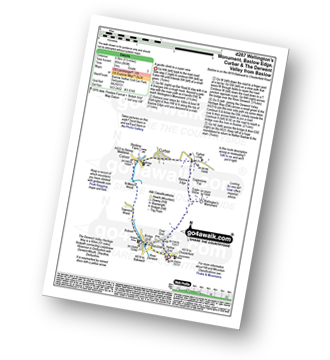
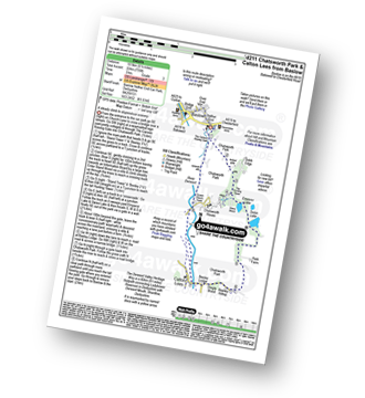
Baslow - The Cannon Kissing Gate - Chatsworth Park - Queen Mary's Bower - Chatsworth House - River Derwent - Calton Lees - Beeley Lodge - Beeley - Beeley Plantation - Hell Bank Plantation - Ravvut Warren - Stand Wood - Swiss Lake - Emperor Lake - Elizabethan Hunting Lodge - Dobb Edge - Heathy Lea Brook - Robin Hood (Baslow) - Birchen Edge Car Park - Three Men - Cupola Cottage - Jack Flat - Wellington's Monument - Eagle Stone - Baslow
|
Vital Statistics:
| Length: | 7.5 miles (12 km) |
| Ascent: | 1,257 ft (383 m) |
| Time: | 4 hrs |
| Grade: | |
Route Summary:
Baslow - Baslow Nether End - Baslow Over End - Gorse Bank Farm - Grislow Field Farm - Lane Farm - Curbar - The Derwent Valley Heritage Way - The River Derwent - Stocking Farm - The Goit - New Bridge - Stoke Brook - Froggatt Bridge - Froggatt - Curbar Edge - Curbar Gap - Baslow Edge - Eagle Stone - Wellington's Monument - Baslow
|
Vital Statistics:
| Length: | 6.5 miles (10.5 km) |
| Ascent: | 735 ft (224 m) |
| Time: | 3 hrs |
| Grade: | |
Route Summary:
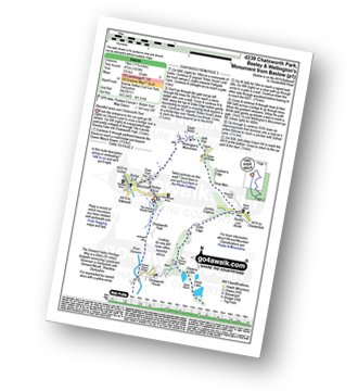
Baslow - The Cannon Kissing Gate - Chatsworth Park - Stand Wood - Elizabethan Hunting Tower - Emperor Lake - Swidd Lake - Rabbit Warren - Beeley Hilltop Farm - Beeley Lodge - Calton Lees - Chatsworth Park - The Derwent Valley Heritage Way - Queen Mary's Tower - Chatsworth House - Chatsworth Park - Baslow
|
Vital Statistics:
| Length: | 5.75 miles (9 km) |
| Ascent: | 890 ft (271 m) |
| Time: | 3 hrs |
| Grade: | |
Route Summary:
Baslow - Bar Brook - The Cannon Kissing Gate - Chatsworth Park - Jubilee Rock - Jumble Coppice - Heathy Lea Brook - Robin Hood (Baslow) - Birchen Edge Car Park - Three Ships - Nelson's Monument (Birchen Edge) - Birchen Edge - Eaglestone Flat - Wellington's Monument - Eagle Stone - Over End - Baslow
Not familiar with the area around DN16?
See these 30 nearest walks to UK Postcode DN16 on a google map


