UK Postcode DL14 - The 30 nearest easy-to-follow, circular walk route maps to you
The thirty nearest easy-to-follow, circular walk route maps to you in UK Postcode DL14 in Walk Grade Order
The UK cities, towns and villages in County Durham, England that have DL14 in their UK Postcode include:
• Bildershaw • Bishop Auckland • Coundon • Coundon Grange • Evenwood • High Etherley • Low Etherley • Morley • Newfield • St Helen Auckland • Toft Hill • West Auckland • Westerton • Witton Park • Witton-le-Wear •
Not familiar with the area around DL14?
See these 30 nearest walks to UK Postcode DL14 on a google map
   |
Vital Statistics:
| Length: | 10.5 miles (17 km) |
| Ascent: | 853ft (260m) |
| Time: | 4½ hrs |
| Grade: |  |

Route Summary:
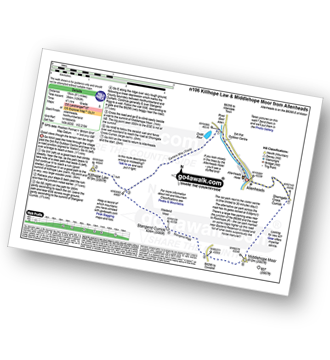
Wolsingham - River Wear - Weardale - The Weardale Way - Ashes House - Towdy Potts - Spence Hill - Harthope - Sunnyside Edge - Elephant Trees - Pikestone Fell - Allotment House - Folly Plantation - Harehope Farm - White Kirkley Farm - Bolihope Burn - Lower Bishopley Farm - Miln House Farm - Bridge End - Frosterley - Weardale - Wolsingham
|
Vital Statistics:
| Length: | 8.5 miles (13.5 km) |
| Ascent: | 1,093ft (333m) |
| Time: | 4.25hrs |
| Grade: | |
Route Summary:
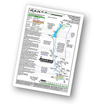
Wolsingham - Waskerley Beck - Holywood House - Bael Hill House - Thistlewood Farm - Wolsingham North Moor - Tunstall Reservoir - Bishop Oak - Wolsingham
|
Vital Statistics:
| Length: | 11 miles (17 km) |
| Ascent: | 1,246ft (380m) |
| Time: | 5.25hrs |
| Grade: |  |

Route Summary:
Frosterley - Wireless Mast - Fatherley Currick - Collier Law - Weatherhill Engine - Heathery Burn - Stanhope Burn - Stanhope - River Wear - Stepping Stones - Weardale - The Weardale Way - Dryburnside Farm - Frosterley
|
Vital Statistics:
| Length: | 17.5 miles (28 km) |
| Ascent: | 1,591ft (485m) |
| Time: | 7.75hrs |
| Grade: |  |
Route Summary:
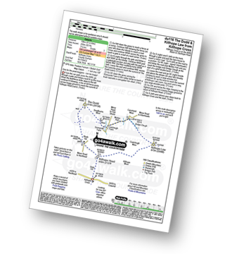
Barningham - Birk Hills Farm - Brown Hill - Cathaw Stoop - Carter Allotment - Badger Way - Badger Way Stoop - How Tallon - How Tallon Gate - How Tallon Ridge - High Moor - Arndale Springs - Frankinshaw How - Holgate Moor - Arndale hole - Kexwith Beck - Kexwith Farm - Moresdale Gill - Moresdale - Moresdale Road - Fair Seat Hill - Moresdale Ridge - Stony Man (St Andrew's Cross) - Booze Moor - Low Moor - Windeg Vein - Little Windeg - Dry Gill Bottom - Shaw Farm - Stang Side - Stang House - Freestone Ridge - Stang Top - Hope Moor - The Stang - Woodcote Gill - Black Hill Gate - Haythwaite Farm - Moorcock Farm - Bragg House - Barningham
|
Vital Statistics:
| Length: | 14.5 miles (23 km) |
| Ascent: | 1,805ft (550m) |
| Time: | 7.25hrs |
| Grade: |  |

Route Summary:
Stanhope - River Wear - Weardale - The Weardale Way - River Wear - Eastgate - Rookhope Burn - Rookhope - C2C Cycle Route - Longlaw End - Bolt's Law (Hunstanworth) - Weatherhill Engine - East Whitely Beck - Stanhope Burn - Stanhope
|
Vital Statistics:
| Length: | 9 miles (14.5 km) |
| Ascent: | 1,730ft (527m) |
| Time: | 5 hrs |
| Grade: | |

Route Summary:
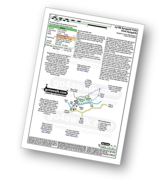
Middleton-in-Teesdale - Hudeshope Beck - Skears Lime Kilns - Club Gill Farm - Coldberry Mine - Coldberry Gutter - Hardberry Hill - Stable Edge - Newbiggin - Newbiggin Bridge - The Pennine Way - Park End Wood - Knott Hill - Middle Crossthwaite - The River Tees - Middleton-in-Teesdale
|
Vital Statistics:
| Length: | 8.25 miles (13 km) |
| Ascent: | 1,172ft (357m) |
| Time: | 4.25hrs |
| Grade: | |

Route Summary:
Middleton-in-Teesdale - River Tees - River Lune - Eller Brook - Grassholme Reservoir - Lunedale - The Pennine Way - Crossthwaite Common - Harter Fell (Crossthwaite Common) - River Tees - Middleton-in-Teesdale
|
Vital Statistics:
| Length: | 7.75 miles (12.5 km) |
| Ascent: | 988ft (301m) |
| Time: | 4 hrs |
| Grade: | |

Route Summary:
Balderhead Reservoir - High Birk Hat Farm - The Pennine Way - Hannah's Meadow - Birk Hat Farm - Blackton Reservoir - Baldsersdale - Willoughby Hall - Scoon Bank - West Brisco - Coproal Hill - East Brisco - How Beck - Lathe Haw - Lathehaw Rigg - Goldsborough Rigg - Goldsborough - East Friar House - Mawmon Sike - Balckton Grange - Balderhead Reservoir
|
Vital Statistics:
| Length: | 12.5 miles (20 km) |
| Ascent: | 1,279ft (390m) |
| Time: | 5.75hrs |
| Grade: | |

Route Summary:
Bowlees - Wynch Bridge - River Tees - Holwick - Low Currick Rigg - Blea Beck - Whiteholm Bank - Dry Beck - Skyer Beck - Birk Rigg - Thistle Green - White Well Green - River Tees - Fox Earths - Raven Scar - Cronkley Scar - Green Hill - Cronkley Pasture - High House - The Pennine Way - Cronkley Farm - Bracken Rigg - Bleabeck Force - High Force - Saur Hill Bridge - Low Force - Wynch Bridge - Bowlees
|
Vital Statistics:
| Length: | 8.5 miles (13.5 km) |
| Ascent: | 1,231ft (375m) |
| Time: | 4½ hrs |
| Grade: | |
Route Summary:
Holwick - Holwick Scars - Rowton Beck - Green Fell - Bink Moss - Dry Gill - Hagworm Hill - Howden Moss - Black Beck - White Rigg - Holwick
|
Vital Statistics:
| Length: | 14 miles (22.5 km) |
| Ascent: | 1,979ft (603m) |
| Time: | 7 hrs |
| Grade: | |

Route Summary:
St John's Chapel - Thatch Mires - Chapelfell Top - Fendrith Hill - Swinhope Moor - Dora's Seat - Swinhope Head - Westernhope Moor - Black Hill (Westernhope Moor) - Littlewood Farm - Brotherlee - Shield - River Wear - Weardale - The Weardale Way - Westgate - Daddry - St John's Chapel
|
Vital Statistics:
| Length: | 9 miles (14.5 km) |
| Ascent: | 1,651ft (503m) |
| Time: | 5 hrs |
| Grade: | |

Route Summary:
St John's Chapel - Thatch Mires - Chapelfell Top - Fendrith Hill - Swinhope Moor - Dora's Seat - Swinhope Head - Swinside House - Daddry Shield - River Wear - Weardale - The Weardale Way - St John's Chapel
|
Vital Statistics:
| Length: | 8.75 miles (14 km) |
| Ascent: | 1,870ft (570m) |
| Time: | 5 hrs |
| Grade: | |
Route Summary:
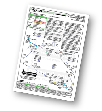
Reeth - Arkle Beck - High Fremington - White House Farm - Fremington Edge - Fremington Edge Top - Fell End Lead Mine - Storthwaite Hall - Arkengarthdale - Langthwaite - Arken Town - Calver Hill - Riddings Farm - Skelgate Lane - Wainwright's Coast to Coast Walk - The Herriot Way - Reeth
|
Vital Statistics:
| Length: | 12.75 miles (20.5 km) |
| Ascent: | 1,935ft (590m) |
| Time: | 6½ hrs |
| Grade: | |

Route Summary:
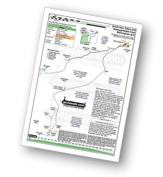
Reeth - River Swale - Harkerside Place Farm - Harker Mires - The Herriot Way - Low Harker Hill - High Harker Hill - Blue Hill - Beldow Hill - Green Hill Ends - Whitaside Moor - ashpot Gutters - Apedale Road (Track) Apedale - Dent's House - Greets Hill - How Hill - Grinton Lodge - The Herriot Way - Grinton - Arkle Beck - Reeth
|
Vital Statistics:
| Length: | 7 miles (11 km) |
| Ascent: | 1,674ft (411m) |
| Time: | 4 hrs |
| Grade: | |

Route Summary:
Reeth - Wainwright's Coast to Coast Walk - Arkle Beck - High Fremington - White House Farm - Fremington Edge - Fremington Edge Top - Fell End Lead Mine - Storthwaite Hall - Arkengarthdale - Castle Farm House - Cuckoo Hill - The Herriot Way - Reeth
Not familiar with the area around DL14?
See these 30 nearest walks to UK Postcode DL14 on a google map
|
Vital Statistics:
| Length: | 9 miles (14.5 km) |
| Ascent: | 1,674ft (510m) |
| Time: | 5 hrs |
| Grade: | |

Route Summary:
Reeth - Wainwright's Coast to Coast Walk - Arkle Beck - High Fremington - White House Farm - Fremington Edge - Fremington Edge Top - Fell End Lead Mine - Storthwaite Hall - Arkengarthdale - Langthwaite - Castle Farm House - Cuckoo Hill - The Herriot Way - Reeth
|
Vital Statistics:
| Length: | 14 miles (22.5 km) |
| Ascent: | 1,743ft (531m) |
| Time: | 7 hrs |
| Grade: | |
Route Summary:
Langdon Beck - Tarn Hole - Tarn Hole Edge - Three Pikes - Grasshill Common - Causeway Hill - Coldberry Edge - Great Stony Hill - Scaud Hill - Redgleam (Harwood Common) - Swallow Hole - Holdenhurth Band - Herdship Fell - Viewing Hill - Backside Fell Bothy - West Common - Touting Hill - Cow Green Reservoir - Widdybank Fell - Langdon Beck
|
Vital Statistics:
| Length: | 5.5 miles (8.5 km) |
| Ascent: | 46ft (14m) |
| Time: | 2 hrs |
| Grade: |  |

Route Summary:
Baltic Square - Gateshead - Millennium Bridge - Newcastle - Quayside Walk - The Hadrian's Way - The Hadrian's Wall Path - Byker Ouseburn Regeneration Centre - Ouse Burn - Spillars Tyne Mill - Hadrian's Cycle Way - St Anthony's - Pottery Bank - St Peters Marina - Quayside Walk - Newcastle - Millennium Bridge - Gateshead.
|
Vital Statistics:
| Length: | 7.5 miles (12 km) |
| Ascent: | 1,287ft (392m) |
| Time: | 4 hrs |
| Grade: | |
Route Summary:
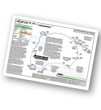
Burnhope Reservoir - Ireshope Moor - Coldberry End - Three Pikes - Coldberry End - Great Stony Hill - Coldberry End - Ireshope Moor - Burnhope Reservoir
|
Vital Statistics:
| Length: | 14 miles (22.5 km) |
| Ascent: | 1,904ft (580m) |
| Time: | 7 hrs |
| Grade: | |
Route Summary:
Burnhope Reservoir - Ireshope Moor - Coldberry End - Three Pikes - Coldberry End - Great Stony Hill - Scaud Hill - Redgleam (Harwood Common) - Burnhope Seat - Dead Stones - White Edge (Burnhope Reservoir) - Lamb's Head - Highwatch Currick - The Malakoff - Bents Head - Stripe End - Burnhope Reservoir
|
Vital Statistics:
| Length: | 11.5 miles (18.5 km) |
| Ascent: | 1,631ft (497m) |
| Time: | 5.75hrs |
| Grade: | |
Route Summary:
Burnhope Reservoir - Ireshope Moor - Coldberry End - Great Stony Hill - Scaud Hill - Redgleam (Harwood Common) - Burnhope Seat - Dead Stones - White Edge (Burnhope Reservoir) - Lamb's Head - Highwatch Currick - The Malakoff - Bents Head - Stripe End - Burnhope Reservoir
|
Vital Statistics:
| Length: | 9.5 miles (15 km) |
| Ascent: | 1,378ft (420m) |
| Time: | 4.75hrs |
| Grade: | |
Route Summary:
Allenheads - Dirt Pots - The Weardale Way - Killhope Law - Stangend Currick - Middlehope Moor - Shorngate Cross - Allenheads
|
Vital Statistics:
| Length: | 12.75 miles (20.5 km) |
| Ascent: | 1,759ft (536m) |
| Time: | 6½ hrs |
| Grade: | |

Route Summary:
Allenheads - Dirt Pots - The Weardale Way - Killhope Law - Shivery Hill - Carshield Moor - Scum Hill - Hartley Moor - Nan Davison's Cleugh - Philipson's Fold - Knockshield Moor - Black Way (Track) - Swinhope Shield - High Knock Shield - Knock Shield - Knockburn Farm - River East Allen - Low Sipton Shield - Sipton Terrace - Teedham Green - Corn Mill - Low Huntwell - Dirt Pots - Allenheads
|
Vital Statistics:
| Length: | 15.75 miles (23.5 km) |
| Ascent: | 1,835ft (559m) |
| Time: | 7.25hrs |
| Grade: | |
Route Summary:
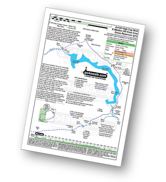
Cow Green Reservoir - Widdybank Fell - Cauldron Snout - The Pennine Way - Birkdale Farm - Grain Beck - Rasp Hill - Maize Beck - High Cup - High Cup Nick - Stake Beck - Meldon Hill (Dufton Fell) - Force Burn - River Tees - Backside Fell Bothy - Cow Green Reservoir
|
Vital Statistics:
| Length: | 11 miles (17.5 km) |
| Ascent: | 2,681ft (817m) |
| Time: | 6.75hrs |
| Grade: | |

Route Summary:
Keld - The Pennine Way - The Herriot Way - The River Swale - Swaledale - Wainwright's Coast to Coast Walk - Kisdon Force - Crackpot Hall - Swinner Gill - Hind Hole Beck - Swinner Gill Lead Mines - East Grain - High Stone Man - Rogan's Seat - Moor Hen Nest - Water Crag (Arkengarthdale) - Blakethwaite Gill - Blakethwaite Meres - Blakethwaite Dams - Gunnerside Gill - Eweleap Scar - Bling Gill - Lownathwaite Mea - High Whim - Swinner Gill - Kisdon Force - Crackpot Hall - Keld
|
Vital Statistics:
| Length: | 11.25 miles (18 km) |
| Ascent: | 2,091ft (637m) |
| Time: | 6.25hrs |
| Grade: | |

Route Summary:
Keld - The Pennine Way - The Herriot Way - Kisdon Force - Black Moor - Stonesdale Moor - The Tan Hill Inn - Tan Gill - Stonesdale Beck - Thomas Gill - Robert's Seat - Pryclose Gutter - Ravenseat - Wainwright's Coast to Coast Walk - Whitsundale Beck - How Edge Scars - Oven Mouth - Cotterby Scar - East Stonesdale Farm - The River Swale - Keld
|
Vital Statistics:
| Length: | 7 miles (11 km) |
| Ascent: | 1,345ft (410m) |
| Time: | 3.75hrs |
| Grade: | |

Route Summary:
Muker - Kisdon - Hooker Mill Scar - Swallow Hole Farm - Keld - The Herriot Way - The Pennine Way - The River Swale - Wainwright's Coast to Coast Walk - Kisdon Force - East Gill Force - Crackpot Hall - Swinner Gill - Arngill Wood - Swaledale - Ramps Holme Bridge - Muker
|
Vital Statistics:
| Length: | 6.25 miles (10 km) |
| Ascent: | 821ft (250m) |
| Time: | 3.25hrs |
| Grade: |  |
Route Summary:
Killhope Cross - Killhope Head - Black Hill - The Dodd - Smallburns Moor - Sunnyside Farm - Coalcleugh Farm - Mufton Hall - Carrshield Moor - Bridge Cleugh - Killhope Law - Killhope Head - Killhope Cross
|
Vital Statistics:
| Length: | 3 miles (4.5 km) |
| Ascent: | 367ft (112m) |
| Time: | 1½ hrs |
| Grade: |  |
Route Summary:
Aysgarth - Aysgarth Falls - High Force - The Herriot Way - Aysgarth Falls - Middle Force - Aysgarth Falls - Low Force - St Josephs Wood - Freeholders' Wood - Aysgarth
|
Vital Statistics:
| Length: | 4 miles (6.5 km) |
| Ascent: | 643ft (196m) |
| Time: | 2.25hrs |
| Grade: | |
Route Summary:
Nenthead - Nenthead Mines Heritage Centre - Shaw Side - Old Carr's Burn - Flinty Fell - Dowgang Hush - Nenthead
Not familiar with the area around DL14?
See these 30 nearest walks to UK Postcode DL14 on a google map


