UK Postcode CO1 - The 30 nearest easy-to-follow, circular walk route maps to you
The thirty nearest easy-to-follow, circular walk route maps to you in UK Postcode CO1 in Walk Grade Order
The UK cities, towns and villages in Essex, England that have CO1 in their UK Postcode include:
• Colchester •
Not familiar with the area around CO1?
See these 30 nearest walks to UK Postcode CO1 on a google map
   |
Vital Statistics:
| Length: | 4.5 miles (7 km) |
| Ascent: | 207 ft (63 m) |
| Time: | 2 hrs |
| Grade: |  |

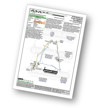
Route Summary:
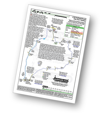
Wherstead - Wherstead Hall - Suffolk Food Hall - Redgate Farm - Freston Brook - The Stour and Orwell Walk - Freston Wood - Freston - Bond Hall Farm - Broom Knoll - Cutler's Wood - Stalls Valley - Valley Farm - Park Farm - Wherstead
|
Vital Statistics:
| Length: | 9 miles (14.5 km) |
| Ascent: | 256 ft (78 m) |
| Time: | 3.75 hrs |
| Grade: |  |
Route Summary:
Takeley - Hope End Green - Cow Common - Hellman's Cross - Taverners Green - Hatfield Broad Oak - Three Forests Way - Pincy Brook - Bush End - Harcamlow Way - The Flitch Way - Takeley
|
Vital Statistics:
| Length: | 7 miles (11 km) |
| Ascent: | 650 ft (198 m) |
| Time: | 3.25 hrs |
| Grade: |  |
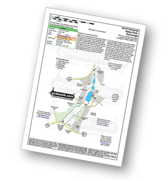
Route Summary:
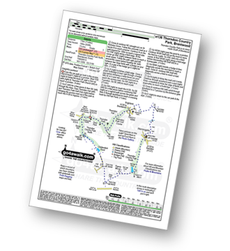
Thorndon Country Park North - Thorndon Park - Thorndon Hall - Ingrave - Herongate - Thorndon Country Park South - Old Hall Pond - Pigeon Mount - Jury Hill - Childerditch Pond - Scrub Hill - Countryside Centre - Thorndon Country Park North
|
Vital Statistics:
| Length: | 6.5 miles (10 km) |
| Ascent: | 82 ft (25 m) |
| Time: | 2½ hrs |
| Grade: | |

Route Summary:
Fulbourn - Harcamlow Way - Cole's Bridge - New Cut Drain - Hawk Mill Farm - Little Wilbraham - Great Wilbraham - Fleam Dyke - Fulbourn
|
Vital Statistics:
| Length: | 5.5 miles (9 km) |
| Ascent: | 118 ft (36 m) |
| Time: | 2 hrs |
| Grade: | |

Route Summary:
Eastbridge - Sandpytle Plantation - The Sluice - Minsmere Nature Reserve - Coastguard Cottages - Dunwich Heath - Eastbridge
|
Vital Statistics:
| Length: | 3.75 miles (6 km) |
| Ascent: | 161 ft (49 m) |
| Time: | 1½ hrs |
| Grade: | |

Route Summary:
Garlinge - Westbrook - Nr Margate - Minster Rd - Shottendane Rd - Woodchurch - Archer Farm - Hengrove Farm - Garlinge
|
Vital Statistics:
| Length: | 6.25 miles (70 km) |
| Ascent: | 240 ft (73 m) |
| Time: | 2½ hrs |
| Grade: | |
Route Summary:
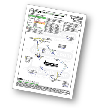
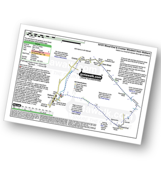
Ardeley - Wood End - Roman Road - Hare Street - Roman Road - Hare Street - Cromer Windmill - Ardeley
|
Vital Statistics:
| Length: | 7.5 miles (12 km) |
| Ascent: | 315 ft (96 m) |
| Time: | 3 hrs |
| Grade: | |
|
Vital Statistics:
| Length: | 4.75 miles (7.5 km) |
| Ascent: | 249 ft (76 m) |
| Time: | 2 hrs |
| Grade: | |
|
Vital Statistics:
| Length: | 2.25 miles (3.5 km) |
| Ascent: | 72 ft (22 m) |
| Time: | 1 hrs |
| Grade: | |
|
Vital Statistics:
| Length: | 7.25 miles (11.5 km) |
| Ascent: | 840 ft (256 m) |
| Time: | 3½ hrs |
| Grade: |  |
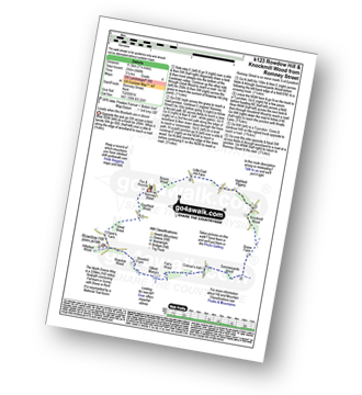
Route Summary:
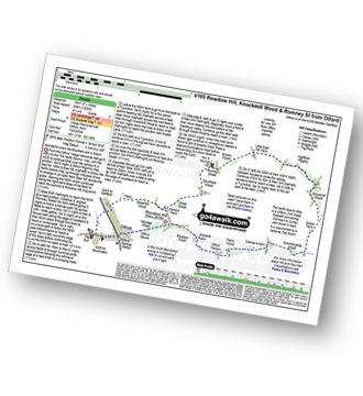
Romney Street - Courtfield Wood - Eastdown - Great Wood - Paine's Farm - Rowdon Hill - The North Downs Way - Rowdow Wood - Shorehill Farm - Otford Manor - Fab's Wood - Cotman's Ash - Summeryards Wood - Knockmill Wood - Highfield Piggery - Little East Hill Farm - Broom Wood - Romney Street
|
Vital Statistics:
| Length: | 4.5 miles (7 km) |
| Ascent: | 295 ft (90 m) |
| Time: | 2 hrs |
| Grade: | |

Route Summary:
Little Gransden - Waresley - Waresley Wood - Waresley Dean Brook - Gransden Wood - Squirrels' Grove - Gransden Park - Great Gransden - Home Dole Brook - Little Gransden
|
Vital Statistics:
| Length: | 5.25 miles (8.5 km) |
| Ascent: | 407 ft (124 m) |
| Time: | 2.25 hrs |
| Grade: | |
|
Vital Statistics:
| Length: | 9.5 miles (15 km) |
| Ascent: | 1,306 ft (398 m) |
| Time: | 4.75 hrs |
| Grade: |  |
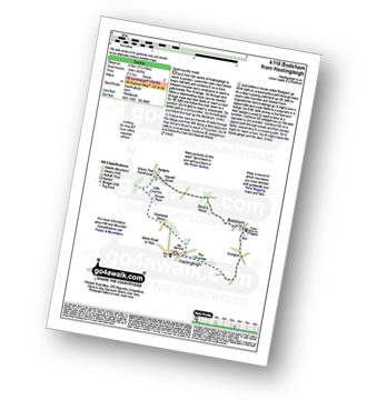
Route Summary:
Otford - The North Downs Way - Otford Mount - Hillydeal Wood - Rowdow Hill - Rowdow Wood - Shorehill Farm - Otford Manor - Fab's Wood - Cotman's Ash - Summeryards Wood - Knockmill Wood - Highfield Piggery - Little East Hill Farm - Broom Wood - Romney Street - Courtfield Wood - Eastdown - Great Wood - Paine's Farm - Greenhill Wood - Otford
|
Vital Statistics:
| Length: | 7 miles (11 km) |
| Ascent: | 141 ft (43 m) |
| Time: | 3 hrs |
| Grade: | |

Route Summary:
Haddiscoe - Thorpe Road - Thorpe Hall - Haddiscoe Marshes - Thorpe Marshes - Thorpe and Haddiscoe Fleet - Haddiscoe Cut Bridge - Willow Farm - Marsh Farm - Lower Thurlton - Haddiscoe
Not familiar with the area around CO1?
See these 30 nearest walks to UK Postcode CO1 on a google map
|
Vital Statistics:
| Length: | 3.5 miles (5.5 km) |
| Ascent: | 98 ft (30 m) |
| Time: | 1½ hrs |
| Grade: | |
Route Summary:
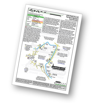
- Norwich (The Forum) - The River Wensum - Fye Bridge - Cow Tower - Bishop's Bridge - Pulls Ferry - The Compleat Angler - Foundry Bridge - Millennium Bridge - Lady Julian Bridge - Carrow Bridge - The Devil's Tower (Eastern Boom Tower) - King Street - Wensum Lodge (a.k.a. The Music House) - Dragon Hall - St Peter of Parmentergate church - St Julian's Church - Novi Sad Friendship Bridge - Timber Hills - The Gardeners Arms (a.k.a. The Murderers) - The Lamb - St Peter Mancroft Church - The Guildhall - Norwich (The Forum)
|
Vital Statistics:
| Length: | 12.5 miles (20 km) |
| Ascent: | 347 ft (106 m) |
| Time: | 4.75 hrs |
| Grade: | |

Route Summary:
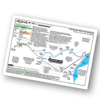
Reedham - Reedham Chain Ferry - Wherryman's Way - Reedham Drainage Mill - River Yare - Reedham Marshes - Seven Mile House - Polkey's Drainage Mill - Cadge's Drainage Mill - Berney Arms Reach - Berney Arms Mill - The Weavers Way - Berney Marshes - Berney Arms Railway Station - Stone's Drainage Mill - Wickhampton Marshes - Wickhampton - Halvergate Road - Reedham Parish Church - Damgate - Holly Farm Road - Reedham
|
Vital Statistics:
| Length: | 7.25 miles (11.5 km) |
| Ascent: | 197 ft (60 m) |
| Time: | 3 hrs |
| Grade: | |

Route Summary:
Somerleyton - The Angles Way - Somerleyton Park - Lound - Green Lane - Waddling Lane - The Angles Way - Wicker Well - Waddling Wood - Somerleyton Railway Station - Somerleyton
|
Vital Statistics:
| Length: | 7.25 miles (11.5 km) |
| Ascent: | 571 ft (174 m) |
| Time: | 3.25 hrs |
| Grade: | |

Route Summary:
Langdon Cliffs Car Park - Dover - The Saxon Shore Way - Langdon Hole - Crab Bay - Fan Point - Bantam Hole - South Foreland Lighthouse - St Margaret's At Cliffe - Bere Wood - Bere Farm - Broadlees Farm - Broadlees Bottom - Langdon Cliffs Car Park - Dover.
|
Vital Statistics:
| Length: | 9.25 miles (14.5 km) |
| Ascent: | 229 ft (70 m) |
| Time: | 3½ hrs |
| Grade: | |
Route Summary:
Halvergate - The Weavers Way - Wickhampton Marshes - Berney Arms Railway Station - Berney Arms Mill - Berney Arms Reach - Breydon Water - Reedham Marshes - Beighton Marshes - Breydon Pump - The Fleet - Halvergate
|
Vital Statistics:
| Length: | 4.5 miles (7 km) |
| Ascent: | 453 ft (138 m) |
| Time: | 2 hrs |
| Grade: | |

|
Vital Statistics:
| Length: | 9 miles (14.5 km) |
| Ascent: | 125 ft (38 m) |
| Time: | 3½ hrs |
| Grade: | |

Route Summary:
Burgh Castle - Burgh Castle Roman Fort - The Angles Way - Breydon Water - Burgh Castle Marshes - Breydon Water Pump House - Fisher's Marshes - Humberstone Marshes - Breydon Bridge - Cobholm Island - Great Yarmouth - Southtown - Ganton Marshes - Bradwell Hall - Burgh Castle
|
Vital Statistics:
| Length: | 6.5 miles (9.5 km) |
| Ascent: | 689 ft (210 m) |
| Time: | 2.75 hrs |
| Grade: | |

Route Summary:
Oxted - The Greensand Way - Limpsfield - The North Downs Way - Tandridge Hill - Townland Pool - Oxted Mill - The Greensand Way - Oxted
|
Vital Statistics:
| Length: | 7.25 miles (11.5 km) |
| Ascent: | 381 ft (116 m) |
| Time: | 3 hrs |
| Grade: | |

Route Summary:
Richmond Park - Pembroke Lodge - Hamcross Plantation - Ham Bottom - Park Gate - Kingston Gate - Robin Hood Gate - Beverley Brook - Roehampton Gate - Adam's Pond - Sheen Gate - The Bog - Richmond Gate - Richmond Park (Richmond Park) - Pembroke Lodge - Richmond Park
|
Vital Statistics:
| Length: | 6.5 miles (10.5 km) |
| Ascent: | 542 ft (165 m) |
| Time: | 3 hrs |
| Grade: | |

Route Summary:
Farthing Downs - Fairdean Downs - Chaldon Church - Chaldon - The North Downs Way - Ockley Hill - Hilltop House - Willey Park Farm - Caterham - Farthing Downs
|
Vital Statistics:
| Length: | 7.75 miles (12.5 km) |
| Ascent: | 135 ft (41 m) |
| Time: | 3 hrs |
| Grade: | |
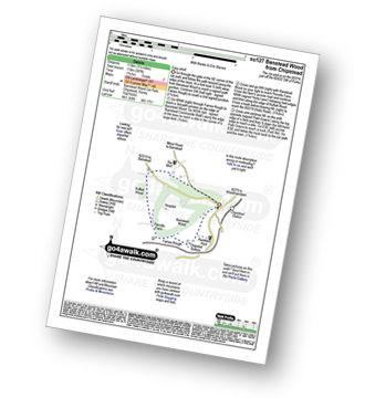
Route Summary:
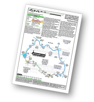
South Walsham Broad - Fleet Dike - Ward Marsh - St Benet's Abbey - River Bure - South Walsham Marshes - Thurne Mouth - Upton Marshes - Upton Black Drainage Mill - Ashby Oby Drainage & sawmill - Clippesby Mill - Upton Dyke - Palmer's Mill - Upton - Duckboards in Upton Broad and Marshes Nature Reserve - Cargate Green - Pilson Green - South Walsham Broad
|
Vital Statistics:
| Length: | 4 miles (6.5 km) |
| Ascent: | 420 ft (128 m) |
| Time: | 2 hrs |
| Grade: | |
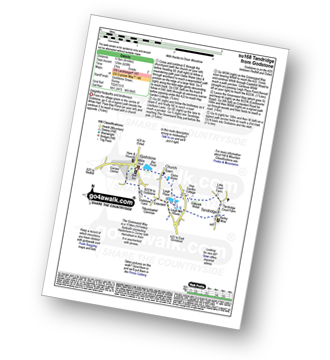
Route Summary:
Godstone - Glebe Water - Church Town - Leigh Place - Oakpark Wood - Tandridge - The Greensand Way - Enterdent - Tilburstowhill Common - Godstone
|
Vital Statistics:
| Length: | 3.75 miles (6 km) |
| Ascent: | 387 ft (118 m) |
| Time: | 1.75 hrs |
| Grade: | |
Route Summary:
Chipstead - Chipstead Bottom - Fames Rough - Perrotts Farm - Ruffett Wood - Chipstead
|
Vital Statistics:
| Length: | 6.5 miles (10.5 km) |
| Ascent: | 637 ft (194 m) |
| Time: | 3 hrs |
| Grade: | |
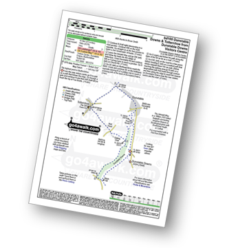
Route Summary:
Dunstable Downs Visitors Centre - The Icknield Way - Five Knolls - Drovers Way - Totternhoe - Well Head - Bison Hill - Dunstable Downs Visitors Centre
|
Vital Statistics:
| Length: | 7.25 miles (11.5 km) |
| Ascent: | 752 ft (229 m) |
| Time: | 3½ hrs |
| Grade: | |
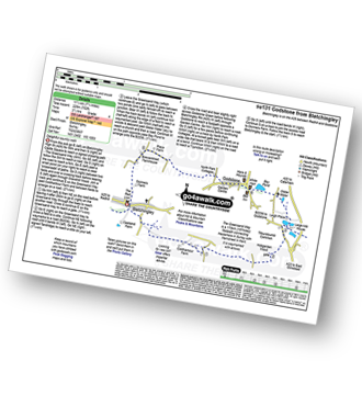
Route Summary:
Bletchingley - The Greensand Way - Coldharbour Farm - Hobgarden Wood - Leigh Place - Glebe Water - Bay Pond - Godstone - Brewer Street - Bletchingley
Not familiar with the area around CO1?
See these 30 nearest walks to UK Postcode CO1 on a google map


