UK Postcode SY19 - The 30 nearest easy-to-follow, circular walk route maps to you
The thirty nearest easy-to-follow, circular walk route maps to you in UK Postcode SY19 in Walk Grade Order
The UK cities, towns and villages in Powys, Wales that have SY19 in their UK Postcode include:
• Bont Dolgadfan • Dylife • Llan • Llanbrynmair • Pandy • Pennant • Pentre-celyn • Plas-rhiw-Saeson • Pont Crugnant • Staylittle • Tafolwern • Talerddig •
Tap/mouse over a coloured circle (1-3 easy walks, 4-6 moderate walks, 7-9 hard walks) and click to select.
Scroll down the list of walks below & click on each walk title (in blue) to locate it on the map above.
   |
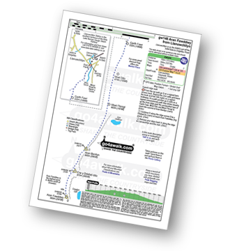
Vital Statistics:
| Length: | 9.5 miles (15 km) |
| Ascent: | 2,777 ft (846 m) |
| Time: | 6½ hrs |
| Grade: |  |
Route Summary:
Aberllefenni - Bryn Coedwig Field Studies Centre - Cwm Ratgoed - Fynnon-Badarn - Ffridd Newydd - Mynydd Ceiswyn - Waun-oer - Cribin Fawr - Craig Portas - Craig Portas (East Top) - Craig Portas - Mynydd Dolgoed - Dolgoed - Ratgoed Hall - Bryn Coedwig - Aberllefenni
|
Vital Statistics:
| Length: | 12.5 miles (20 km) |
| Ascent: | 3,738 ft (1,139 m) |
| Time: | 8.25 hrs |
| Grade: |  |
Route Summary:
Aberllefenni - Bryn Coedwig Field Studies Centre - Cwm Ratgoed - Fynnon-Badarn - Ffridd Newydd - Mynydd Ceiswyn - Waun-oer - Cribin Fawr - Craig Portas - Craig Portas (East Top) - Maesglase (Craig Rhiw-erch) - Maesglase (Maen Du) - Craig Portas (East Top) - Craig Portas - Mynydd Dolgoed - Dolgoed - Ratgoed Hall - Bryn Coedwig - Aberllefenni
|
Vital Statistics:
| Length: | 10 miles (16 km) |
| Ascent: | 2,353 ft (717 m) |
| Time: | 6 hrs |
| Grade: | |

Route Summary:
Nant-y-moch Reservoir - Nant-y-moch - Y Garn (Pumlumon) - Dyll Faen - Pen y Drawsallt - Pen Pumlumon Fawr (Plynlimon) - Pumlumon Fach - Pumlumon Fach (East Top) - Pen Pumlumon Llygad-bychan - Pen Pumlumon Arwystli - Craig y March - Cwm Gwerin - Lluest y Graig - Afon Hengwm - Pantau'r Brwyn - Nant y Llyn - Maesnant - Bryn y Beddau - Nant-y-moch Reservoir
|
Vital Statistics:
| Length: | 7.5 miles (12 km) |
| Ascent: | 2,721 ft (829 m) |
| Time: | 5½ hrs |
| Grade: | |

Route Summary:
Cwm Cywarch - Tai-newyddion - Blaencywarch - Llyn Bach - Glasgwm - Llyn y Fign - Pen y Brynfforchog - Nant y Craig-wen - Craig Cywarch - Y Gribin (Arans) - Cwm Yr Ychen - Cwm Cywarch
|
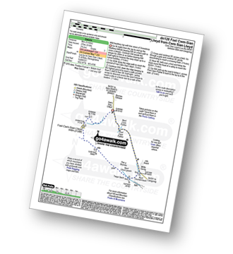
Vital Statistics:
| Length: | 12 miles (19 km) |
| Ascent: | 4,050 ft (1,234 m) |
| Time: | 8½ hrs |
| Grade: | |
Route Summary:
Cwm Cywarch - Afon Cywarch - Waun Camddwr - Camddwr - Gwaun y Llwyni - Aran Fawddwy - Erw y Ddafad-ddu - Aran Benllyn - Aran Fawddwy (South Top) - Drws Bach - Drysgol (Aran Fawddwy) - Gwaun Lydan - Pumryd Fawr - Waun Goch - Pen yr Allt Uchaf - Allt Uchaf - Ty'n-y-ddol - Cwm Cywarch
|
Vital Statistics:
| Length: | 6 miles (9.5 km) |
| Ascent: | 3,218 ft (981 m) |
| Time: | 5½ hrs |
| Grade: | |

Route Summary:
Minffordd Hotel - Afon Faw - Ystrad-gwyn - Nant Cadair - The Minffordd Path - Llyn Cau - Craig Lwyd - Craig Cwm Amarch - Craig Cau - Cadair Idris (Penygadair) - Mynydd Moel - Mynydd Moel Path - Minffordd.
|
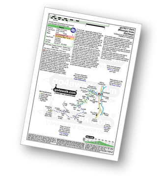
Vital Statistics:
| Length: | 10.5 miles (17 km) |
| Ascent: | 4,060 ft (1,237 m) |
| Time: | 8 hrs |
| Grade: | |
Route Summary:
Minffordd Hotel - Afon Faw - Ystrad-gwyn - Nant Cadair - The Minffordd Path - Llyn Cau - Craig Lwyd - Craig Cwm Amarch - Craig Cau - Cadair Idris (Penygadair) - Cyfrwy - Cadair Idris (Penygadair) - Mynydd Moel - Gau Graig - Mynydd Gwerngraig - A487 - Nant Yr Allt-ioen - Cwm Rhwyddfor - Bwlch Llyn Bach - Minffordd.
|
Vital Statistics:
| Length: | 10.5 miles (17 km) |
| Ascent: | 3,328 ft (1,014 m) |
| Time: | 7.25 hrs |
| Grade: |  |
Route Summary:
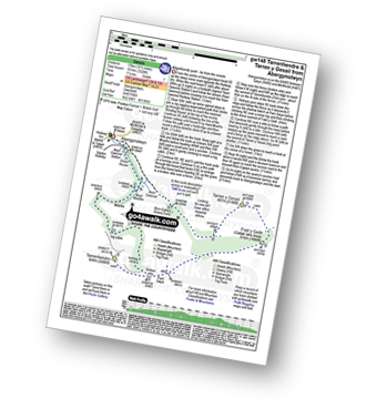
Abergynolwyn - Nant Gwernol - Nant Gwernol Station - Drum House - Nant Moelfre - Moelfre - Tarrenhendre - Pant Gwyn (Tarrenhendre) - Mynydd Rhyd-galed - Foel y Geifr - Tarren y Gesail - Bryn-Eglwys Quarry - Abergynolwyn
|
Vital Statistics:
| Length: | 7.75 miles (12.5 km) |
| Ascent: | 2,281 ft (695 m) |
| Time: | 5.25 hrs |
| Grade: | |
Route Summary:
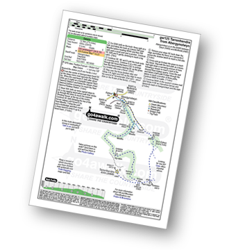
Abergynolwyn - Nant Gwernol - Nant Gwernol Station - Drum House - Nant Moelfre - Moelfre - Tarrenhendre - Pant Gwyn (Tarrenhendre) - Bryn-Eglwys Quarry - Abergynolwyn
|
Vital Statistics:
| Length: | 11 miles (17.5 km) |
| Ascent: | 2,839 ft (865 m) |
| Time: | 6.75 hrs |
| Grade: | |

Route Summary:
Bwlch y Groes - Gwaun Yr Hen-Luest - Clipiau-Duon - Llechwedd Du (Arans) - Afon Twrch - Foel Rhudd - Esgeiriau Gwynion - Bwlch Sirddyn - Foel Hafod-fynydd - Creiglyn Dyfi - Llaethnant - Ceunant y Briddell - Pen y Craig - Natn Llewlyn-goch - Blaen-pennant - Afon Rhiwlech - Foel y Groes - Moel y Cerrig Duon - Bwlch y Groes
|
Vital Statistics:
| Length: | 10 miles (16 km) |
| Ascent: | 2,737 ft (834 m) |
| Time: | 6½ hrs |
| Grade: | |

Route Summary:
Llanfihangel-y-pennant - Tynyfach - Gwastadfryn - Hafotty Gwastaffryn - Rhiw Gwerdydd - Carnedd Lwyd - Tyrrau Mawr (Craig-las) - Tyrau Mawr (Craig-las) - Craig-y-llyn - Twll y Ogof - Bodilan Fach - Afon Cadair - Llanfihangel-y-pennant
|
Vital Statistics:
| Length: | 10.5 miles (17 km) |
| Ascent: | 3,627 ft (1,105 m) |
| Time: | 7½ hrs |
| Grade: | |
Route Summary:
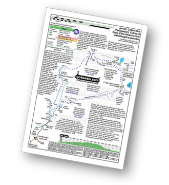
Llanfihangel-y-pennant - Afon Cadair - Tynyfach - Gwastadfryn - Hafotty Gwastaffryn - Rhiw Gwerdydd - The Pony Path - Cyfrwy - Cadair Idris (Penygadair) - Craig Cau - Craig Cwm Amarch - Mynydd Pencoed - Pencoed - Llanfihangel-y-pennant
|
Vital Statistics:
| Length: | 6 miles (9.5 km) |
| Ascent: | 1,194 ft (364 m) |
| Time: | 3.25 hrs |
| Grade: |  |

Route Summary:
The Arch - Coed Yr Arch - Coed y Cwm - Bryn-llwyd - Coed y Ceuleth - Truman - Rhos Peiran - Craig U Ceffyl - Pen Y Garn (Bryn Garw) - Banc Myheryn - Rhos Nantperfedd - Glemast Farm - Rhos y Cwm - The Arch
|
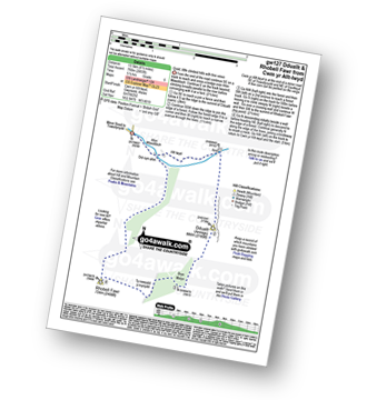
Vital Statistics:
| Length: | 9.75 miles (15.5 km) |
| Ascent: | 4,247 ft (1,294 m) |
| Time: | 7.75 hrs |
| Grade: | |
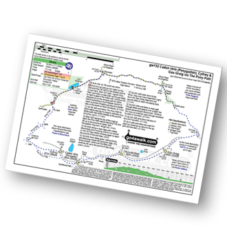
Route Summary:
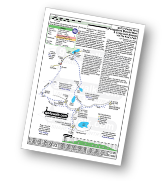
Llyn Gwernan - Llyn Gafr - The Fox's Path - Cadair Idris (Penygadair) - Mynydd Moel - Craig Cwm Amarch - Craig Cau - The Pony Path - Cyfrwy - Rhiw Gwerdydd - Llyn Gwernan
|
Vital Statistics:
| Length: | 11.25 miles (18.5 km) |
| Ascent: | 3,558 ft (1,084 m) |
| Time: | 7.75 hrs |
| Grade: | |
Route Summary:
Llyn Gwernan - The Pony Path - Rhiw Gwerdydd - Cyfrwy - Cadair Idris (Penygadair) - Mynydd Moel - Gau Graig - Bwlch-coch - Pandy Gader - Afon Arran - Rhydwen - Llyn Gwernan
|
Vital Statistics:
| Length: | 4.5 miles (7 km) |
| Ascent: | 1,454 ft (443 m) |
| Time: | 4 hrs |
| Grade: |  |

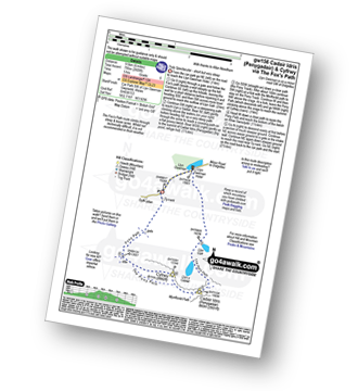
Route Summary:
Llyn Gwernan - The Pony Path - Llyn y Cadair - The Fox's Path (lower Section) - Llyn Gafr - Llyn Gwernan
|
Vital Statistics:
| Length: | 6 miles (9.5 km) |
| Ascent: | 2,609 ft (975 m) |
| Time: | 5 hrs |
| Grade: | |
Route Summary:
Llyn Gwernan - Llyn Gafr - Llyn y Cadair - The Fox's Path - Cadair Idris (Penygadair) - The Pony Path - Cyfrwy - Rhiw Gwerdydd - Llyn Gwernan
|
Vital Statistics:
| Length: | 3.5 miles (5.5 km) |
| Ascent: | 289 ft (88 m) |
| Time: | 1.75 hrs |
| Grade: |  |

Route Summary:
Coed y Groes - Gwern Offeiriaid - The Precipice Walk - Ffridd Dol-Fawr - Foel Faner (fort) - Llyn Cynwych - Gwern Offeiriaid - Coed y Groes
|
Vital Statistics:
| Length: | 8.5 miles (13.5 km) |
| Ascent: | 2,406 ft (733 m) |
| Time: | 5½ hrs |
| Grade: | |
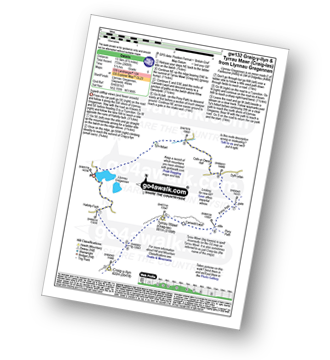
Route Summary:
Llynnau Cregennen - Hafotty-fach - Craig-y-llyn - Tyrrau Mawr (Craig-las) - Tyrau Mawr (Craig-las) - Carnedd Lwyd - Rhiw Gwerdydd - Pony Path - Dyffr-ydan - Cefn-yr-Owen Isaf - Ty'n-llidiart - Llynnau Cregennen
|
Vital Statistics:
| Length: | 7.5 miles (12 km) |
| Ascent: | 1,588 ft (484 m) |
| Time: | 4½ hrs |
| Grade: |  |
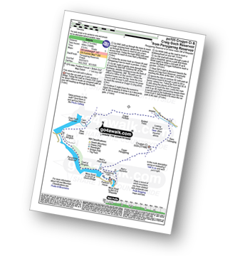
Route Summary:
Penygarreg Reservoir - Nant y Blymbren - Penygarreg Farm - Esgair Penygarreg (Crugyn Ci) - Banc Trehesglog - Briddell Fell - Esgair Perfedd - Cwm Garw - Rhiw Caws - Craig Goch Reservoir - Craig Yr Allt-goch - Coed Yr Allt-goch - Penygarreg Reservoir
|
Vital Statistics:
| Length: | 5 miles (8 km) |
| Ascent: | 1,375 ft (419 m) |
| Time: | 3.25 hrs |
| Grade: | |

Route Summary:
Arthog - Afon Arthog - Arthog Waterfalls - Pant Phylip - Llys-Bradwen - Llynnau Cregennan - Cregennen Lakes - Pared y Cefn hir - Pant y Cae - Tan y Coed - Arthog
|
Vital Statistics:
| Length: | 10.5 miles (17 km) |
| Ascent: | 3,273 ft (998 m) |
| Time: | 7 hrs |
| Grade: | |
Route Summary:
Llanuwchllyn - Pont y Pandy - Garth Fawr - Moel Ddu - Moel Ffenigl - Aran Benllyn - Erw y Ddafad-ddu - Aran Fawddwy - Llanuwchllyn
|
Vital Statistics:
| Length: | 5.5 miles (8.5 km) |
| Ascent: | 2,032 ft (619 m) |
| Time: | 4 hrs |
| Grade: | |
Route Summary:
Ganllwyd - Cwm Camlan - Afon Camlan - Rhaeadr Du - Black Waterfalls - Coed Ganllwyd - Ffridd Bryn-melyn - Nant Las - Bryn Bedwog - Y Garn (Rhinogs) - Bryn Bedwog - Nant Las - Ffridd Bryn-melyn - Coed Ganllwyd - Black Waterfalls - Rhaeadr Du - Afon Camlan - Cwm Camlan - Ganllwyd
|
Vital Statistics:
| Length: | 4.75 miles (7.5 km) |
| Ascent: | 1,628 ft (496 m) |
| Time: | 3½ hrs |
| Grade: | |

Route Summary:
Hirnant Pass - Foel Goch (Berwyns) - Trum y Gwrgedd - Trum y Gwragedd - Foel y Geifr (Berwyns) - Pen y Cerrig - Hirnant Pass
|
Vital Statistics:
| Length: | 10.5 miles (17 km) |
| Ascent: | 2,081 ft (634 m) |
| Time: | 6 hrs |
| Grade: | |

Route Summary:
Hirnant Pass - Pen y Cerrig - Pen y Boncyn Trefeilw - Stac Rhos - Cefn Gwyntog - Foel Cedig - Cyrniau Nod - Y Groes Fagl - Pennllyn Forest - Ystrad-y-groes - Hirnant Pass
|
Vital Statistics:
| Length: | 12.75 miles (20.5 km) |
| Ascent: | 2,763 ft (842 m) |
| Time: | 7½ hrs |
| Grade: | |

Route Summary:
Hirnant Pass - Foel Goch (Berwyns) - Trum y Gwrgedd - Trum y Gwragedd - Foel y Geifr (Berwyns) - Pen y Cerrig Duon - Pen y Boncyn Trefeilw - Stac Rhos - Cefn Gwyntog - Foel Cedig - Cyrniau Nod - Y Groes Fagl - Pennllyn Forest - Ystrad-y-groes - Hirnant Pass
|
Vital Statistics:
| Length: | 8.5 miles (13.5 km) |
| Ascent: | 2,493 ft (760 m) |
| Time: | 5½ hrs |
| Grade: | |
Route Summary:
Cwm Yr Allt-lwyd - Afon Mawddach - Dduallt (Arenigs) - Bryn Melyn - Ty-newydd-y-mynydd - Rhobell Fawr - Cwm Yr Allt-lwyd
|
Vital Statistics:
| Length: | 7.75 miles (12.5 km) |
| Ascent: | 1,575 ft (480 m) |
| Time: | 4½ hrs |
| Grade: | |

Route Summary:
Elan Valley Visitor Centre - Caban-coch Reservoir Dam - Caban-coch Reservoir - Craig Cnwch - Nant-y-Gro Dam - Ty'n-y-pant - Dolymynach Reservoir - Llanerch Cawr Longhouse - Craig y Mynach - Nant Gwyllt - Penglaneinon Farm - Coed Aberelan - Garreg-ddu Reservoir - Caban-coch Reservoir - Elan Valley Visitor Centre
|
Vital Statistics:
| Length: | 4.75 miles (7.5 km) |
| Ascent: | 916 ft (279 m) |
| Time: | 2.75 hrs |
| Grade: | |
Route Summary:
Cwm Sian Llwyd - Foel Cwm-Sian Llwyd - Trwyn Swch - Nant Llwyn-gwerh - Nant Ceunant-bach - Milltir Gerrig - Pont Cwm Pydew - Nant Cwm Pydew - Cwm Sian Llwyd
|
Vital Statistics:
| Length: | 12.75 miles (20.5 km) |
| Ascent: | 3,180 ft (969 m) |
| Time: | 7.75 hrs |
| Grade: | |

Route Summary:
Pistyll Rhaeadr Waterfall - Tan-y-pistyll - Nant y Llyn - LLyn Lluncaws - Cadair Berwyn - Cadair Berwyn (North Top) - Moel Sych - Ceulan Myheryn - Post Gwyn - Y Clogydd - Glan Hafon (Y Garn) - Afon Yr Ast - Pistyll Rhaeadr - Tan-y-pistyll.


