UK Postcode PL26 - The 30 nearest easy-to-follow, circular walk route maps to you
The thirty nearest easy-to-follow, circular walk route maps to you in UK Postcode PL26 in Walk Grade Order
The UK cities, towns and villages in Cornwall, England that have PL26 in their UK Postcode include:
• Belowda • Bilberry • Bodwen • Boswinger • Bugle • Carthew • Coombe • Foxhole • Gorran Churchtown • Gorran Haven • Hewas Water • High Street • Lockengate • Mevagissey • Nanpean • Penare • Pentewan • Penwithick • Polgooth • Polmassick • Portholland • Porthpean • Retew • Roche • Ruddlemoor • St Dennis • St Ewe • St Mewan • St Michael Caerhays • St Stephen • Stenalees • Sticker • Trenarren • Trethurgy • Trevarrick • Treviscoe • Victoria •
Tap/mouse over a coloured circle (1-3 easy walks, 4-6 moderate walks, 7-9 hard walks) and click to select.
Scroll down the list of walks below & click on each walk title (in blue) to locate it on the map above.
   |
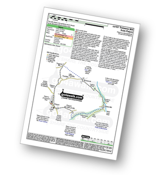
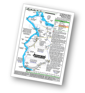
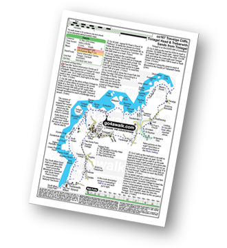
Vital Statistics:
| Length: | 7 miles (11 km) |
| Ascent: | 1,086 ft (331 m) |
| Time: | 3.75 hrs |
| Grade: |  |

Route Summary:
Mawgan Porth - Bracken Cott - Vale of Mawgan - St Mawgan - Trevarrian - Tregurrian - Watergate Bay - The South West Coast Path - Ontonna Rock - Stem Point - Griffin's Point - Beacon Cove - Berryl's Point - Butt Rock - Grange Point - Mawgan Porth
|
Vital Statistics:
| Length: | 6 miles (9.5 km) |
| Ascent: | 1,076 ft (328 m) |
| Time: | 3.25 hrs |
| Grade: | |
Route Summary:
Pelynt - Outways Farm - Tregarrick Mill - Muchlarnick - Yearle's Wood - West Looe River - Sowden's Bridge - Trelawne Mill - Kiln Wood - Cathrinepark Wood - Pelynt
|
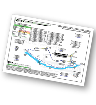
Vital Statistics:
| Length: | 5.5 miles (9 km) |
| Ascent: | 1,407 ft (448 m) |
| Time: | 3½ hrs |
| Grade: | |

Route Summary:
Crumplehorn - Polperro - Landaviddy Manor - Raphael - Little Lizzen - East Coombe - The South West Coast Path - East Coombe - Broad Cove - Shag Rock - Colours Cove - Chapel Cliff - Polperro - Crumplehorn
|
Vital Statistics:
| Length: | 8 miles (12 km) |
| Ascent: | 1,759 ft (536 m) |
| Time: | 4½ hrs |
| Grade: |  |
Route Summary:
Crumplehorn - Polperro - Landaviddy Manor - Raphael - Great Tregue - Lansallos - West Coombe - The South West Coast Path - East Coombe - Broad Cove - Shag Rock - Colours Cove - Chapel Cliff - Polperro - Crumplehorn
|
Vital Statistics:
| Length: | 5.25 miles (8.5 km) |
| Ascent: | 1,260 ft (384 m) |
| Time: | 3.25 hrs |
| Grade: | |

Route Summary:
Crumplehorn - Longcoombe Mill - Watergate House - Sclerder Abbey - Porthallow - Talland Bay - The South West Coast Path - Downend Point - Polperro - Crumplehorn
|
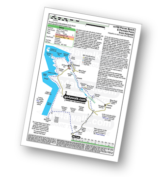
Vital Statistics:
| Length: | 4.5 miles (7 km) |
| Ascent: | 748 ft (228 m) |
| Time: | 2½ hrs |
| Grade: |  |
Route Summary:
Pentire Farm - Porth Mear - The South West Coast Path - High Cove - Park Head - Mackerel Cove - Pentire Steps - Diggory's Island - Bedruthan Steps - Pendarve Point - Whitestone Cove - Bedruthan Steps Visitor Centre - B3276 - Pentire Farm
|
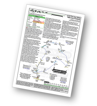
Vital Statistics:
| Length: | 4.75 miles (7.5 km) |
| Ascent: | 876 ft (267 m) |
| Time: | 2½ hrs |
| Grade: | |

Route Summary:
West Pentire - The South West Coast Path - Pentire Point West - Porth Joke - Kelsey Head - Holywell Bay - Holywell Beach - Holywell - The Kelseys - Cuthbert Common - West Pentire
|
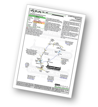
Vital Statistics:
| Length: | 7.75 miles (12.5 km) |
| Ascent: | 1,306 ft (398 m) |
| Time: | 4.25 hrs |
| Grade: | |
Route Summary:
Holywell - Ellenglaze - Trebisken House - Mount Farm - Penhale Sands (Dunes) - St Prian's Church (Penhale Sands) - St Piran's Oratory (Penhale Sands) - The South West Coast Path - Perran Beach - Liggar Bay - Perran Bay - Liggar Point - Hoblyn's Cove - Penhale Point - Holywell Bay - Holywell
|
Vital Statistics:
| Length: | 6.25 miles (10 km) |
| Ascent: | 945 ft (288 m) |
| Time: | 3.25 hrs |
| Grade: | |

Route Summary:
Padstow - Padstow Harbour - The South West Coast Path - St Saviour's Point - St George's Cove - Gun Point - Harbour Cove - Hawker's Cove - The Narrows - Old Boad - Stepper Point - Stepper Point Beacon - Crams - Pepper Hole - Butter Hole - Ginver Head - Middle Merope Islands - Crugmeer - Tregirls Farm - Prideaux Place - Padstow - Padstow Harbour.
|
Vital Statistics:
| Length: | 11.75 miles (19 km) |
| Ascent: | 1,867 ft (569 m) |
| Time: | 6.25 hrs |
| Grade: |  |
Route Summary:
Rock (Padstow Bay) - The South West Coast Path - Brea Hill - Daymer Bay (Trebetherick) - Trebetherick Point - Greenaway Beach - Broadagogue Cove - Hayle Bay - Trebetherick - Polzeath - New Polzeath - Slipper Point - Pentireglaze Haven - Pentire Point - Pentire Head - Guglane - Rumps Point - Sandinway Beach - Com Head - Pengrit Cove - Downhedge Cove - Pentireglaze - Portkillock Farm - Roserrow - Pityme - Splatt - Stoptide - Rock (Padstow Bay)
|
Vital Statistics:
| Length: | 6.5 miles (10 km) |
| Ascent: | 755 ft (230 m) |
| Time: | 3 hrs |
| Grade: | |
Route Summary:
Rock (Padstow Bay) - Porthilly Cove - Stoptide - Rock (Padstow Bay) - St Endoc Golf Course - St Endoc Church - Trebetherick - The South West Coast Path - Broadagogue Cove - Greenaway Beach - Padstow Bay - Daymer Bay (Trebetherick) - Brea Hill - Rock (Padstow Bay)
|
Vital Statistics:
| Length: | 3.75 miles (6 km) |
| Ascent: | 630 ft (192 m) |
| Time: | 2 hrs |
| Grade: |  |

Route Summary:
Duloe - Duloe Stone Circle - Gillhill Wood - West Looe River - Tremadart Wood - Churchbridge - Duloe
|
Vital Statistics:
| Length: | 7.25 miles (11.5 km) |
| Ascent: | 1,119 ft (341 m) |
| Time: | 3.75 hrs |
| Grade: | |
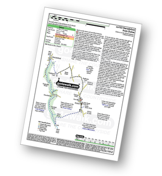
Route Summary:
Duloe - Duloe Stone Circle - Gillhill Wood - West Looe River - Tremadart Wood - Churchbridge - Pendruffle Wood - Herodsfoot - Carglonnon Farm - Black Down - Bodbrane Farm - Polvean Cross - Duloe
|
Vital Statistics:
| Length: | 5 miles (8 km) |
| Ascent: | 952 ft (290 m) |
| Time: | 2.75 hrs |
| Grade: | |
Route Summary:
Constantine Bay - The South West Coast Path - Treyarnon Point - Treyarnon Bay - Trethias Island - Pepper Cove - Warren Cove - Fox Cove - Minnows Islands - Will's Rock - Porthcothan Bay - Carnevas - Trethias Farm - Treyarnon Farm - Constantine Bay
|
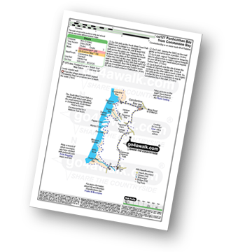
Vital Statistics:
| Length: | 7.5 miles (12 km) |
| Ascent: | 1,533 ft (467 m) |
| Time: | 4.25 hrs |
| Grade: | |

Route Summary:
Millpool Car Park - West Looe - East Looe - The South West Coast Path - Hannafore Point - Portnadler Bay - Hore Stone - Talland Bay - Talland Church - Tencreek Campsite - Parkers Cross - Kilminorth - Watergate - West Looe River - Kilminorth Wood - West Looe - East Looe.
|
Vital Statistics:
| Length: | 6.25 miles (10 km) |
| Ascent: | 1,122 ft (342 m) |
| Time: | 3½ hrs |
| Grade: | |

Route Summary:
Millpool Car Park - West Looe - East Looe - The South West Coast Path - Hannafore Point - Portnadler Bay - Hore Stone - Talland Bay - Talland Church - Tencreek Campsite - Portlooe - West Looe - East Looe.
|
Vital Statistics:
| Length: | 8.25 miles (13.5 km) |
| Ascent: | 958 ft (292 m) |
| Time: | 4 hrs |
| Grade: | |
Route Summary:
Daymer Bay (Trebetherick) - The South West Coast Path - Trebetherick Point - Greenaway Beach - Broadagogue Cove - Hayle Bay - Trebetherick - Polzeath - New Polzeath - Slipper Point - Pentireglaze Haven - Pentireglaze - Portkillock Farm - Roserrow - Pityme - Splatt - Stoptide - Rock (Padstow Bay) - St Endoc Church - Daymer Bay (Trebetherick)
|
Vital Statistics:
| Length: | 4 miles (6.5 km) |
| Ascent: | 391 ft (119 m) |
| Time: | 2 hrs |
| Grade: | |

Route Summary:
Daymer Bay (Trebetherick) - The South West Coast Path - Brea Hill - Rock (Padstow Bay) - St Endoc Golf Course - St Endoc Church - Daymer Bay (Trebetherick)
|
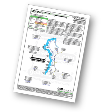
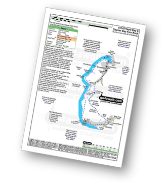
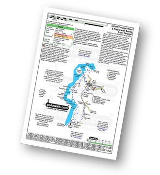
Vital Statistics:
| Length: | 11 miles (17.5 km) |
| Ascent: | 1,657 ft (505 m) |
| Time: | 5½ hrs |
| Grade: | |
Route Summary:
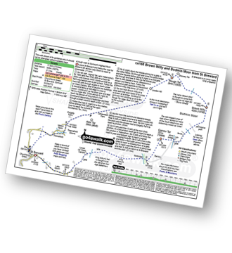
St Breward - Churchtown - Lady Down - West Candra - Lower Candra - King Arthur's Hall - Bodmin Moor - Garrow Tor - Butter's Tor - Brown Willy - Little Rough Tor - Rough Tor - Louden Hill - Alex Tor - Treswallock - St Breward
|
Vital Statistics:
| Length: | 5.5 miles (9 km) |
| Ascent: | 1,208 ft (368 m) |
| Time: | 3½ hrs |
| Grade: | |

Route Summary:
Trebetherick - The South West Coast Path - Polzeath - New Polzeath - Slipper Point - Pentireglaze Haven - Pentire Point - Pentire Head - Guglane - Rumps Point - Sandinway Beach - Com Head - Pengrit Cove - Downhedge Cove - Pentireglaze - Polzeath - Trebetherick
|
Vital Statistics:
| Length: | 7.25 miles (11.5 km) |
| Ascent: | 1,805 ft (550 m) |
| Time: | 4½ hrs |
| Grade: | |
Route Summary:
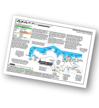
Port Isaac - Port Gaverne - Trewetha - Trelights - Rosecarrock Farm - Port Quin - Kellan Head - Downgate Cove - Greengarden Cove - Varley Head - Varley Sands - Pine Haven - Lobber Point - Port Isaac
|
Vital Statistics:
| Length: | 6.75 miles (11 km) |
| Ascent: | 1,234 ft (376 m) |
| Time: | 3.75 hrs |
| Grade: | |

Route Summary:
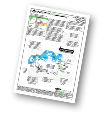
Tintagel - Fenterleigh - St Nectan's Glen - St Piran's Church - Trethevey - Trevalga - The South West Coast Path - Ladies Window - Trevalga Cliff - Trewthet Gut - Trewethett Mill - Rocky Valley - Benoath Cove - Bossiney Haven - Gullastern - Smith Cliff - Barras Gut - Barras Nose - Tintagel Haven - Tintagel Castle - Tintagel Head - Tintagel
|
Vital Statistics:
| Length: | 5 miles (8 km) |
| Ascent: | 1,096 ft (334 m) |
| Time: | 3 hrs |
| Grade: | |
Route Summary:
Tintagel - Fenterleigh - St Nectan's Glen - St Piran's Church - Trethevey - Trevelleit Mill - Trewethett Mill - Rocky Valley - The South West Coast Path - Benoath Cove - Bossiney Haven - Gullastern - Smith Cliff - Barras Gut - Barras Nose - Tintagel Haven - Tintagel Castle - Tintagel Head - Tintagel
|
Vital Statistics:
| Length: | 10.75 miles (17 km) |
| Ascent: | 1,983 ft (568 m) |
| Time: | 5.75 hrs |
| Grade: | |
Route Summary:
Tintagel - Fenterleigh - St Nectan's Glen - St Piran's Church - Trethevey - Trevalga - The South West Coast Path - Ladies Window - Trevalga Cliff - Trewthet Gut - Trewethett Mill - Rocky Valley - Benoath Cove - Bossiney Haven - Gullastern - Smith Cliff - Barras Gut - Barras Nose - Tintagel Haven - Tintagel Head - Glebe Cliff - Dunderhole Point - Penhallic Point - Hole Beach - Trebarwith Sands - Trelake - Treknow - Two Acre Farm - Tintagel
|
Vital Statistics:
| Length: | 4.75 miles (7.5 km) |
| Ascent: | 807 ft (246 m) |
| Time: | 2½ hrs |
| Grade: | |
Route Summary:
Tintagel - Tintagel Castle - Tintagel Haven - Tintagel Head - Glebe Cliff - Dunderhole Point - Penhallic Point - Hole Beach - Trebarwith Sands - Trelake - Treknow - Two Acre Farm - Tintagel
|
Vital Statistics:
| Length: | 4.5 miles (7 km) |
| Ascent: | 561 ft (171 m) |
| Time: | 2.25 hrs |
| Grade: | |
Route Summary:
Fivelanes - Five Lanes - Altarnun - Penpont Water - Penhallow Manor - Higher Tregunnon Farm - Lower Tregunnon - Trenarrett - Penpont Water - Tresmaine - Altarnun - Fivelanes
|
Vital Statistics:
| Length: | 7.5 miles (12 km) |
| Ascent: | 1,109 ft (338 m) |
| Time: | 4 hrs |
| Grade: | |
Route Summary:
Fivelanes - Five Lanes - Altarnun - Penpont Water - Penhallow Manor - Higher Tregunnon Farm - River Inny - Laneast - Treroose - Trespearne - Gimblett's Mill - River Inny - Trethinna - Trerithick - Little Trenarrett - Penpont Water - Tresmaine - Altarnun - Fivelanes
|
Vital Statistics:
| Length: | 5 miles (8 km) |
| Ascent: | 673 ft (205 m) |
| Time: | 2½ hrs |
| Grade: | |
Route Summary:
Laneast - Treroose - Trespearne - Gimblett's Mill - River Inny - Trethinna - Trerithick - Trenarrett - Lower Tregunnon - Higher Tregunnon Farm - River Inny - Laneast
|
Vital Statistics:
| Length: | 7 miles (11 km) |
| Ascent: | 1,789 ft (545 m) |
| Time: | 4½ hrs |
| Grade: | |
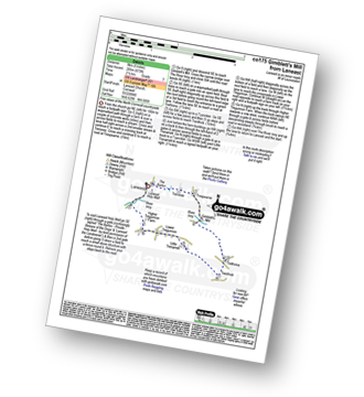
Route Summary:
Boscastle - The South West Coast Path - River Valency - Boscastle Harbour - Penally Point - Penally Hill - Pentargon Bay - Pentargon Falls - Beeny Cliff - Seals Hole - Fire Beacon Point - Beeny - Trebyla Farm - Penvention Farm - St Julietta's Church - River Valency - Boscastle
|
Vital Statistics:
| Length: | 11.25 miles (18 km) |
| Ascent: | 3,197 ft (974 m) |
| Time: | 7½ hrs |
| Grade: |  |
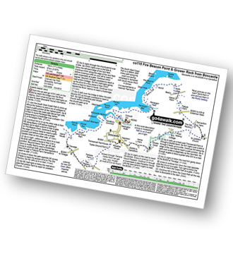
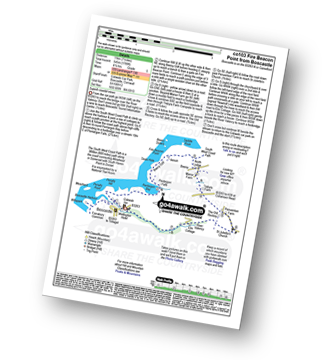
Route Summary:
Boscastle - The South West Coast Path - River Valency - Boscastle Harbour - Penally Point - Penally Hill - Pentargon Bay - Pentargon Falls - Beeny Cliff - Seals Hole - Fire Beacon Point - Beeny - Trebyla Farm - Penvention Farm - St Julietta's Church - River Valency - Minster Wood - Upper Boscastle - Trehane Farm - Trevalga - The South West Coast Path - Grower Rock - Grower Gut - Western Blackapit - Willapark - Boscastle Harbour - Boscastle


