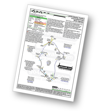
UK Postcode GL52 - The 30 nearest easy-to-follow, circular walk route maps to you
The thirty nearest easy-to-follow, circular walk route maps to you in UK Postcode GL52 in Walk Grade Order
The UK cities, towns and villages in Gloucestershire, England that have GL52 in their UK Postcode include:
• Bishop's Cleeve • Charlton Kings • Cheltenham • Cleeve Hill • Gotherington • Oxenton • Prestbury • Southam • Stoke Orchard • Woodmancote •
Tap/mouse over a coloured circle (1-3 easy walks, 4-6 moderate walks, 7-9 hard walks) and click to select.
Scroll down the list of walks below & click on each walk title (in blue) to locate it on the map above.
   |
Vital Statistics:
| Length: | 8.25 miles (13 km) |
| Ascent: | 912 ft (278 m) |
| Time: | 4 hrs |
| Grade: |  |

Route Summary:
Seven Springs - Coberley - The Gloucestershire Way - Cowley - Cockleford - Butlers Hill Farm - Butler's Farm - Colesbourne - Forty Acre Plantation - Balbarrow Wood - The Forest - Pinswell Plantation - Mercombe Wood - Hilcot Wood - Upper Coberley - New Farm Bungalow - Seven Springs
|
Vital Statistics:
| Length: | 5.5 miles (9 km) |
| Ascent: | 669 ft (204 m) |
| Time: | 2.75 hrs |
| Grade: |  |
Route Summary:
Seven Springs - Coberley - The Gloucestershire Way - Cowley - Cockleford - Westbury Farm - Tomtit's Bottom - Upper Coberley - New Farm Bungalow - Seven Springs
|
Vital Statistics:
| Length: | 8.5 miles (13.5 km) |
| Ascent: | 951 ft (290 m) |
| Time: | 4 hrs |
| Grade: | |

Route Summary:
Winchcombe - River Isbourne - The Cotswold Way - Salter's Lane - Hailes Abbey - North Farmcote - Lynes Barn - Campden Lane (Track) - Deadmanbury Gate - Wardens' Way - Salt Way - The Warren - Parks Farm - Sudeley Lodge - Sudeley Castle - Winchcombe
|
Vital Statistics:
| Length: | 5.75 miles (9 km) |
| Ascent: | 571 ft (174 m) |
| Time: | 2.75 hrs |
| Grade: | |

Route Summary:
Chedworth Roman Villa - The Macmillan Way - River Coln - Yanworth Common - Yanworth Wood - Streetfold - Yanworth - Dean Grove - Sheep Wash - Oxpens Farm - The Monarch's Way - Stowell Grove - Budford's Grove - Yanworth Mill - River Coln - Chedworth Woods - Chedworth Roman Villa
|
Vital Statistics:
| Length: | 9 miles (14.5 km) |
| Ascent: | 754 ft (230 m) |
| Time: | 4 hrs |
| Grade: | |

Route Summary:
Chedworth - Woodlands Farm - Postcombe - Withington Woods - Withington - River Coln - Woodbridge - Cassey Compton - Turpin's Green - Hutnage - Chedworth Roman Villa - The Monarch's Way - The Macmillan Way - Yanworth Mill - Chedworth Woods - Chedworth
|
Vital Statistics:
| Length: | 10.75 miles (17 km) |
| Ascent: | 689 ft (210 m) |
| Time: | 4.75 hrs |
| Grade: | |
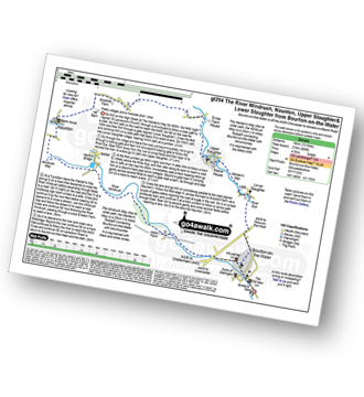
Route Summary:
Bourton-on-the-Water - The Warden's Way - River Eye - Lower Slaughter - Upper Slaughter - Brockhill Farm - Naunton - The Windrush Way - River Windrush - Aston Farm - Bourton-on-the-Water
|
Vital Statistics:
| Length: | 6.75 miles (11 km) |
| Ascent: | 312 ft (95 m) |
| Time: | 3 hrs |
| Grade: |  |

Route Summary:
Bourton-on-the-Water - Little Rissington - Great Rissington - New Bridge - River Windrush - Bourton-on-the-Water
|
Vital Statistics:
| Length: | 6 miles (9.5 km) |
| Ascent: | 508 ft (155 m) |
| Time: | 2½ hrs |
| Grade: | |

Route Summary:
Stow-on-the-Wold - The Monarch's Way - Broadwell - Donnington - Battle of Stow Memorial - The Gloucestershire Way - Upper Swell - Stow-on-the-Wold
|
Vital Statistics:
| Length: | 10.25 miles (16.5 km) |
| Ascent: | 463 ft (141 m) |
| Time: | 4.25 hrs |
| Grade: | |

Route Summary:
Moreton-in-Marsh - The Mornarch's Way - Upper Fields Farm - Longborough - Donnington - Broadwell - Quinmoor Far - River Evenlode - Evenlode - Codicote Farm - Moreton-in-Marsh
|
Vital Statistics:
| Length: | 8.25 miles (13 km) |
| Ascent: | 696 ft (212 m) |
| Time: | 3.75 hrs |
| Grade: | |

|
Vital Statistics:
| Length: | 9 miles (14.5 km) |
| Ascent: | 801 ft (244 m) |
| Time: | 4.25 hrs |
| Grade: | |

Route Summary:
Adlestrop - The Macmillan Way - Chastleton - Chastleton House - Chastleton Barrow Iron Age Fort - Cornwell - Daylesford - The Macmillan Way - Lower Oddington - Adlestrop Park - Adlestrop
|
Vital Statistics:
| Length: | 6.25 miles (10 km) |
| Ascent: | 670 ft (204 m) |
| Time: | 3 hrs |
| Grade: | |
Route Summary:
Adlestrop - The Macmillan Way - Chastleton - Chastleton House - Chastleton Barrow Iron Age Fort - Cornwell - Adlestrop
|
Vital Statistics:
| Length: | 3.75 miles (6 km) |
| Ascent: | 394 ft (120 m) |
| Time: | 1.75 hrs |
| Grade: | |
Route Summary:
Adlestrop - The Macmillan Way - Chastleton - Chastleton House - Chastleton Barrow Iron Age Fort - Long Drive - Adlestrop
|
Vital Statistics:
| Length: | 6.25 miles (10 km) |
| Ascent: | 1,615 ft (492 m) |
| Time: | 4 hrs |
| Grade: |  |
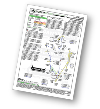
Route Summary:
Upper Wyche - Malvern (Worcestershire Beacon) - Sugarloaf Hill (Malverns) - North Hill (Malverns) - Table Hill (Malverns) - End Hill (Malverns) - The Malvern Hills Outdoor Centre - Birches Farm - West Malvern - Mathon Lodge Farm - Coneycroft Farm - The Perlieu - Upper Wyche
|
Vital Statistics:
| Length: | 4.75 miles (7.5 km) |
| Ascent: | 1,405 ft (428 m) |
| Time: | 3.25 hrs |
| Grade: | |

Route Summary:
Uley - Uley Bury Hill Fort - Cliff Wood - Crawley Barns - The Cotswolds Way - Hodgecombe Farm - Cam Long Down - Peaked Down - Uleyfield - Downham Hill (Smallpox Hill) - Hydegate - Uley Bury Hill Fort - Uley
|
Vital Statistics:
| Length: | 6.25 miles (10 km) |
| Ascent: | 558 ft (170 m) |
| Time: | 2.75 hrs |
| Grade: | |
Route Summary:
Burford - Fulbrook - Widley Copse - Dean Bottom - Widford Church - River Windrush - Burford
|
Vital Statistics:
| Length: | 5.5 miles (9 km) |
| Ascent: | 400 ft (122 m) |
| Time: | 2½ hrs |
| Grade: | |
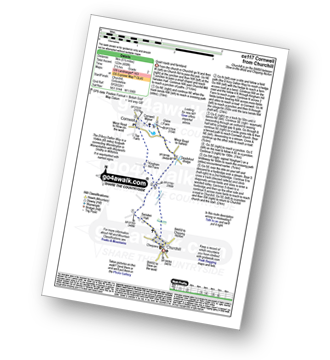
Route Summary:
Churchill - Sarsden Halt. Kingham Hill Farm - Cornwell - Swailsford Bridge - Churchill
|
Vital Statistics:
| Length: | 6.5 miles (10.5 km) |
| Ascent: | 272 ft (83 m) |
| Time: | 2.75 hrs |
| Grade: | |

Route Summary:
Shipton Under Wychwood - Milton Under Wychwood - Grange Farm - Home Farm - Foxholes Nature Reserve - The Oxfordshire Way - Bruern Abbey - Shipton Under Wychwood
|
Vital Statistics:
| Length: | 7 miles (11 km) |
| Ascent: | 420 ft (128 m) |
| Time: | 3 hrs |
| Grade: | |

|
Vital Statistics:
| Length: | 8.75 miles (14 km) |
| Ascent: | 574 ft (175 m) |
| Time: | 3.75 hrs |
| Grade: | |

Route Summary:
Charlbury - The Oxfordshire Way - Dean Grove - Coldron Mill - Spelsbury - Taston - Taston Village Cross - The Wychwood Way - Inotts Clump - Shilcott Wood - Ditchley Park - Charlbury
|
Vital Statistics:
| Length: | 7 miles (11 km) |
| Ascent: | 151 ft (46 m) |
| Time: | 2.75 hrs |
| Grade: | |

Route Summary:
Stratford-upon-Avon - Tramway - River Stour - Clifford Chambers - The Greenway - River Avon - Stratford-upon-Avon
|
Vital Statistics:
| Length: | 6 miles (9.5 km) |
| Ascent: | 496 ft (151 m) |
| Time: | 2.75 hrs |
| Grade: | |

Route Summary:
Coleshill - Brimstone Farm - Badbury Hill Fort - Badbury Hill - Great Coxwell - Ashen Copse Farm - Flamborough Wood - Coleshill Park - Coleshill
|
Vital Statistics:
| Length: | 8.25 miles (13 km) |
| Ascent: | 1,719 ft (524 m) |
| Time: | 4½ hrs |
| Grade: | |

Route Summary:
Symonds Yat - Symonds Yat Rock - The River Wye - The Slughter - The Wye Valley Walk - The Biblins - The Gosling Ash - Near Hearkening Rock - The Suck Stone - Staunton (Coleford) - Braceland - Motiva Ropes Course - Symonds Yat
|
Vital Statistics:
| Length: | 6.25 miles (10 km) |
| Ascent: | 1,847 ft (563 m) |
| Time: | 4 hrs |
| Grade: | |

Route Summary:
Symonds Yat - Symonds Yat Rock - Saracen's Head Ferry - The River Wye - King Arthur's Cave - Seven Sisters Rocks - The Wye Valley Walk - The Biblins - The Gosling Ash - The Slaughter - Symonds Yat
|
Vital Statistics:
| Length: | 10 miles (16 km) |
| Ascent: | 2,335 ft (712 m) |
| Time: | 6 hrs |
| Grade: |  |

Route Summary:
Symonds Yat - Symonds Yat Rock - Saracen's Head Ferry - The River Wye - King Arthur's Cave - Seven Sisters Rocks - The Wye Valley Walk - The Biblins - The Gosling Ash - Near Hearkening Rock - The Suck Stone - Staunton (Coleford) - Braceland - Motiva Ropes Course - Symonds Yat
|
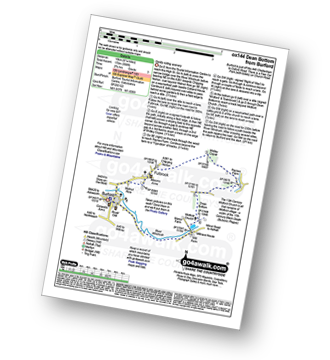
Vital Statistics:
| Length: | 7.25 miles (15.5 km) |
| Ascent: | 584 ft (178 m) |
| Time: | 3.25 hrs |
| Grade: | |

Route Summary:
Bushton - Parsonage Farm - Common Farm - Boradtown Road Farm - Cotmarsh - Tyning Farm - The White Horse Trail - Broad Town White Horse - Broadtown Hill - Preachers' Point - Broad Town - Clyffe Pypard - Bushton
|
Vital Statistics:
| Length: | 9.75 miles (15 km) |
| Ascent: | 555 ft (169 m) |
| Time: | 4 hrs |
| Grade: | |

Route Summary:
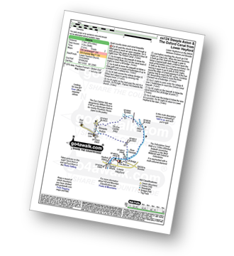
Lower Heyford - Heyford Wharfe - The Oxford Canal - The Eye Catcher - Steeple Aston - Three Corner Clump - Middle Aston - Warren Lodge - Hendon Farm - North Aston - The Manor - River Cherwell - Somerton - The Oxfordshire Canal Walk - The Oxford Canal - Somerton Crossing - Heyford Common Lock - Allens Lock - Lower Heyford
|
Vital Statistics:
| Length: | 6.75 miles (11 km) |
| Ascent: | 427 ft (130 m) |
| Time: | 3 hrs |
| Grade: | |
Route Summary:
Lower Heyford - Heyford Wharfe - The Oxford Canal - The Eye Catcher - Steeple Aston - Three Corner Clump - Middle Aston - River Cherwell - Somerton Crossing - The Oxfordshire Canal Walk - The Oxford Canal - Heyford Common Lock - Allens Lock - Lower Heyford
|
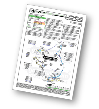
Vital Statistics:
| Length: | 4.75 miles (7.5 km) |
| Ascent: | 368 ft (112 m) |
| Time: | 2.25 hrs |
| Grade: | |
Route Summary:
Lower Heyford - Heyford Wharfe - The Oxford Canal - Steeple Aston - The Eye Catcher (Folly) - River Cherwell - The Oxfordshire Canal Walk - The Oxford Canal - Allens Lock - Lower Heyford
|
Vital Statistics:
| Length: | 8.5 miles (13.5 km) |
| Ascent: | 873 ft (266 m) |
| Time: | 4 hrs |
| Grade: | |

Route Summary:
Aldbourne - The Giant's Grave - Upper Upham - The Ridgeway - Sugar Hill - Four Barrows - Aldbourne


