6 walks in The Cambrian Mountains and Pembrokeshire
The Cambrian Mountains and Pembrokeshire area is the area of mid-Wales between Snowdonia to the north and The Brecon Beacons to the south.
Interactive Map of Walks in The Cambrian Mountains and Pembrokeshire
![]() How to Load this interactive map: Due to usage restrictions, you must be Registered and Logged-On to go4awalk.com to view and use the interactive Google Map below. You do not need to purchase any credits, but you must be Registered and Logged-On.
How to Load this interactive map: Due to usage restrictions, you must be Registered and Logged-On to go4awalk.com to view and use the interactive Google Map below. You do not need to purchase any credits, but you must be Registered and Logged-On.
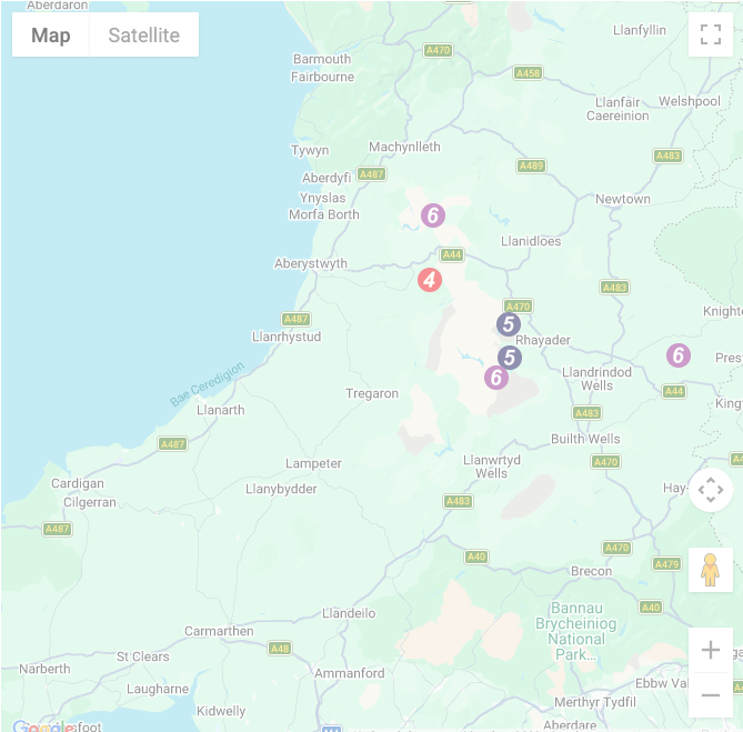
You can use these checkboxes to show only the grades of walk you are interested in:-
Six easy-to-follow, circular, walk route maps in The Cambrian Mountains and Pembrokeshire in Walk Grade Order
See this list of walks, routes & maps in:
Grade Order | Length Order | Time Order | Walk Number or Start Location Order
NB. To reverse (toggle) this order, click Grade Order again
Scroll down the list of walks below & click on each walk title (in blue) to locate it on the map above.
   |
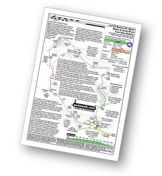
Vital Statistics:
| Length: | 10 miles (16 km) |
| Ascent: | 2,353 ft (717 m) |
| Time: | 6 hrs |
| Grade: |  |

Route Summary:
Nant-y-moch Reservoir - Nant-y-moch - Y Garn (Pumlumon) - Dyll Faen - Pen y Drawsallt - Pen Pumlumon Fawr (Plynlimon) - Pumlumon Fach - Pumlumon Fach (East Top) - Pen Pumlumon Llygad-bychan - Pen Pumlumon Arwystli - Craig y March - Cwm Gwerin - Lluest y Graig - Afon Hengwm - Pantau'r Brwyn - Nant y Llyn - Maesnant - Bryn y Beddau - Nant-y-moch Reservoir
|
Vital Statistics:
| Length: | 6 miles (9.5 km) |
| Ascent: | 1,194 ft (364 m) |
| Time: | 3.25 hrs |
| Grade: |  |

Route Summary:
The Arch - Coed Yr Arch - Coed y Cwm - Bryn-llwyd - Coed y Ceuleth - Truman - Rhos Peiran - Craig U Ceffyl - Pen Y Garn (Bryn Garw) - Banc Myheryn - Rhos Nantperfedd - Glemast Farm - Rhos y Cwm - The Arch
|
Vital Statistics:
| Length: | 9 miles (14.5 km) |
| Ascent: | 1,963 ft (598 m) |
| Time: | 5.25 hrs |
| Grade: | |
Route Summary:
New Radnor - Whinyard Rocks - Bache Hill - Head of Ystol Bach Brook - Black Mixen - Shepherd's Well - Cross Dyke - Great Rhos - Davy Morgan's Dingle - Harley Dingle - Lower Harley - Harley Dingle Brook - Harley Gorse - New Radnor
|
Vital Statistics:
| Length: | 7.5 miles (12 km) |
| Ascent: | 1,588 ft (484 m) |
| Time: | 4½ hrs |
| Grade: |  |
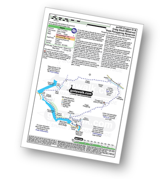
Route Summary:
Penygarreg Reservoir - Nant y Blymbren - Penygarreg Farm - Esgair Penygarreg (Crugyn Ci) - Banc Trehesglog - Briddell Fell - Esgair Perfedd - Cwm Garw - Rhiw Caws - Craig Goch Reservoir - Craig Yr Allt-goch - Coed Yr Allt-goch - Penygarreg Reservoir
|
Vital Statistics:
| Length: | 11 miles (17.5 km) |
| Ascent: | 1,900 ft (579 m) |
| Time: | 6 hrs |
| Grade: | |
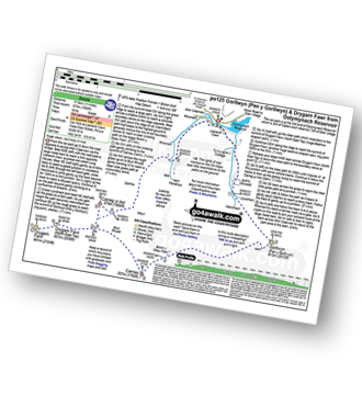
Route Summary:
Dolymynach Reservoir - Afon Claerwen - Llanerch Cawr - Llywdnant - Marchnant - Gorllwyn (Pen y Gorllwyn) - Bwlch Ddau Faen - Carnau - Bryn Rhudd - Drygarn Fawr (North East Top) - Drygarn Fawr - Carreg Yr Ast - Nant Paradwys - Rhiwnant - Dolymynach Reservoir
|
Vital Statistics:
| Length: | 7.75 miles (12.5 km) |
| Ascent: | 1,575 ft (480 m) |
| Time: | 4½ hrs |
| Grade: | |

Route Summary:
Elan Valley Visitor Centre - Caban-coch Reservoir Dam - Caban-coch Reservoir - Craig Cnwch - Nant-y-Gro Dam - Ty'n-y-pant - Dolymynach Reservoir - Llanerch Cawr Longhouse - Craig y Mynach - Nant Gwyllt - Penglaneinon Farm - Coed Aberelan - Garreg-ddu Reservoir - Caban-coch Reservoir - Elan Valley Visitor Centre
See this list of walks, routes & maps in:
Grade Order | Length Order | Time Order | Walk Number or Start Location Order
NB. To reverse (toggle) this order, click Grade Order again


