22 easy-to-follow walk route maps of all grades in The Scottish Borders region of Scotland
Twenty-two easy-to-follow walk route maps of all grades in The Scottish Borders region of Scotland in Walk Grade Order
The Scottish Borders is the area enclosed by an imaginary line connecting:
- Glasgow to North Berwick via the Forth and Clyde Canal and the Firth of Forth, Queensferry and Edinburgh to the North;
- North Berwick to Berwick-upon-Tweed via the North Sea to the North East
- Berwick-upon-Tweed to Gretna Green via the border between Scotland & England to the South East
- Gretna Green to Glasgow via the A74(M) past Lockerbie, Moffat, Douglas and Hamilton to the South West
Tap/mouse over a coloured circle (1-3 easy walks, 4-6 moderate walks, 7-9 hard walks) and click to select.
Not familiar with the The Scottish Borders region of Scotland?
See these 22 walks in The Scottish Borders on an interactive Google Map
See this list of walks, routes & maps in:
Grade Order | Length Order | Time Order | Walk Number or Start Location Order
NB. To reverse (toggle) this order, click Grade Order again
   |
Vital Statistics:
| Length: | 8.25 miles (13 km) |
| Ascent: | 1,520 ft (463 m) |
| Time: | 4½ hrs |
| Grade: |  |
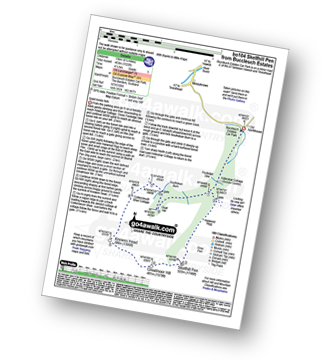
Route Summary:
Buccleuch Estates (Teviothead - Teviotdale) - Fouledge Syke - Alderybar Cottage - Harwood Rigg - Grey Pen - Skelfhill Pen - Greatmoor Hill - Knowes Head - Coltercleugh Shiel Cottage - Goat Hill - Buccleuch Estates (Teviothead).
|
Vital Statistics:
| Length: | 6.25 miles (10 km) |
| Ascent: | 758 ft (231 m) |
| Time: | 3 hrs |
| Grade: |  |
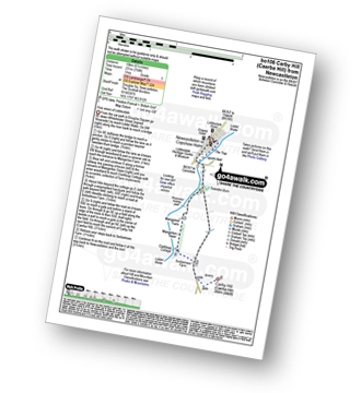
Route Summary:
Newcastleton - Liddesdale - Liddel Water - Tweeden Burn - Mangerton Tower - Sorbietrees Farm - Carby Hill (Caerba Hill) - Newcastleton or Copshaw Holme.
|
Vital Statistics:
| Length: | 7.25 miles (11.5 km) |
| Ascent: | 2,009 ft (612 m) |
| Time: | 4.75 hrs |
| Grade: | |
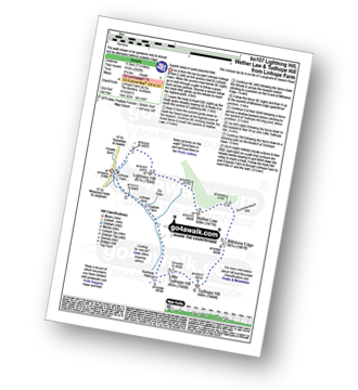
Route Summary:
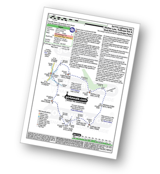
Linhope Farm - Lightning Hill - Wether Law (Teviothead) - Crummiecleuch Rig - Millstone Edge (Tudhope Hill) - Tudhope Hill - Little Tudhope Hill - Sunhope Hass - Elygrain Farm - Linhope Burn - Linhope Farm
|
Vital Statistics:
| Length: | 8.75 miles (14 km) |
| Ascent: | 3,482 ft (1,061 m) |
| Time: | 7 hrs |
| Grade: |  |
Route Summary:
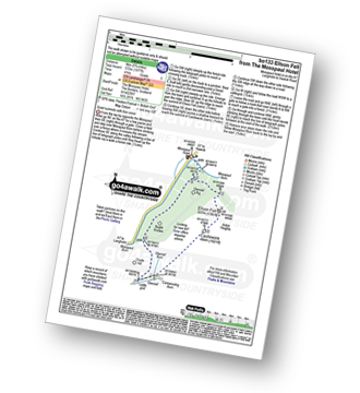
Mosspaul Hotel - Wisp Hill (Teviothead) - Ewenshope Fell - Ewes Doors - Pikethaw Hill - Frodaw Height - Dan's Hags - Upper Hill (Fiddleton Cottage) - Fiddleton Cottage - Glenrief Cottage - Castlewink - Ellson Fell - Glenrief Rig - Mosspaul Burn - Mosspaul Hotel
|
Vital Statistics:
| Length: | 8.75 miles (14 km) |
| Ascent: | 2,793 ft (851 m) |
| Time: | 6 hrs |
| Grade: |  |
Route Summary:
Linhope Farm - Lightning Hill - Wether Law (Teviothead) - Crummiecleuch Rig - Millstone Edge (Tudhope Hill) - Tudhope Hill - Little Tudhope Hill - Sunhope Hass - Carlin Tooth (Teviothead) - Bye Hill - Dod Hill (Teviothead) - Linhope Burn - Linhope Farm
|
Vital Statistics:
| Length: | 14.5 miles (23 km) |
| Ascent: | 2,018 ft (615 m) |
| Time: | 7.25 hrs |
| Grade: | |

Route Summary:
Newcastleton or Copshaw Holm - Bedda Cleuch - Blackburn Farm - Kiln Knowe - Black Burn - Hog Gill - Rigging Sike - Millstone Edge (Roan Fell) - Roan Fell - Watch Hill - Strait Hill - Cooms Fell - Black Edge - Watch Crags - Loch Knowe - Tinnis Bridge - Hazelyside Hill - Bedda Hill - Newcastleton
|
Vital Statistics:
| Length: | 10 miles (16 km) |
| Ascent: | 2,238 ft (682 m) |
| Time: | 6 hrs |
| Grade: | |

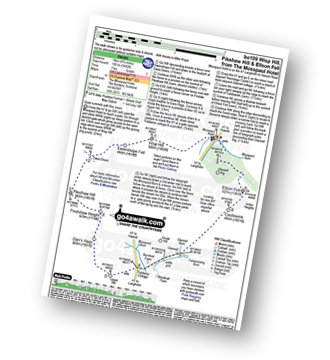
Route Summary:
Tow Ford - Dere Street - Woden Law - Langside Law - Buchtrig Farm - Humblemoor Hill - Little Humblemoor - The Hows - Tronshaw Hill - Upper Chatto - Chatto - Towford Farm - Kale Water - Tow Farm.
|
Vital Statistics:
| Length: | 8.5 miles (13.5 km) |
| Ascent: | 2,832 ft (863 m) |
| Time: | 5.75 hrs |
| Grade: | |

Route Summary:
Mosspaul Hotel - Wisp Hill (Teviothead) - Ewenshope Fell - Ewes Doors - Pikethaw Hill - Frodaw Height - Dan's Hags - Upper Hill (Fiddleton Cottage) - Fiddleton Cottage - Bught Knowe - Glenrief Rig - Mosspaul Burn - Mosspaul Hotel
|
Vital Statistics:
| Length: | 8.75 miles (14 km) |
| Ascent: | 1,260 ft (384 m) |
| Time: | 4½ hrs |
| Grade: | |

Route Summary:
Morebattle - The St Cuthbert's Way - Kale Water - Grubbit Law - Cushat End - Hownam Law - South Cote - Howgate - Heavyside - Gateshaw - Morebattle
|
Vital Statistics:
| Length: | 4.5 miles (7 km) |
| Ascent: | 1,503 ft (458 m) |
| Time: | 3.25 hrs |
| Grade: |  |

Route Summary:
Linhope Farm - Linhope Burn - Dod Hill (Teviothead) - Bye Hill - Carlin Tooth (Teviothead) - Sunhope Hass - Linhope Burn - Elygrain Farm - Linhope Farm
|
Vital Statistics:
| Length: | 4 miles (6.5 km) |
| Ascent: | 1,057 ft (322 m) |
| Time: | 2.75 hrs |
| Grade: | |

Route Summary:
Tow Ford - Dere Street - Woden Law - Langside Law - Buchtrig Farm - Kale Water - Tow Farm.
|
Vital Statistics:
| Length: | 5.75 miles (9 km) |
| Ascent: | 1,877 ft (572 m) |
| Time: | 4 hrs |
| Grade: | |
Route Summary:
Mosspaul Hotel - Mosspaul Burn - Glenrief Rig - Ellson Fell - Castlewink - Glenrief Cottage - Bught Knowe - Glenrief Rig - Mosspaul Burn - Mosspaul Hotel
|
Vital Statistics:
| Length: | 13.25 miles (21 km) |
| Ascent: | 2,586 ft (788 m) |
| Time: | 7.25 hrs |
| Grade: | |

Route Summary:
Ettrick Water,Longhope Burn - Bught Hill - Bodesbeck Law - Nowtrig Head - Mid Rig (Bell Craig) - Salmongill Craig - Bald Craig - Bell Craig - Mirk Side - Andrewhinney Hill - Brockhope Head - Trowgrain Middle - Herman Law - Fala Grain - Back Beck - Brockhoperig - Ettrick Water
|
Vital Statistics:
| Length: | 7 miles (11 km) |
| Ascent: | 1,408 ft (429 m) |
| Time: | 4 hrs |
| Grade: | |

Route Summary:
Towford Farm - Kale Water - Buchtrig Farm - Humblemoor Hill - Little Humblemoor - The Hows - Tronshaw Hill - Upper Chatto - Chatto - Towford Farm
|
Vital Statistics:
| Length: | 7.5 miles (12 km) |
| Ascent: | 2,018 ft (615 m) |
| Time: | 4.75 hrs |
| Grade: | |

Route Summary:
Mosspaul Hotel - Wisp Hill (Teviothead) - Ewenshope Fell - Ewes Doors - Ewelees Farm - Fiddleton Cottage - Bught Knowe - Glenrief Rig - Mosspaul Burn - Mosspaul Hotel
|
Vital Statistics:
| Length: | 4 miles (6.5 km) |
| Ascent: | 958 ft (292 m) |
| Time: | 2½ hrs |
| Grade: | |
Route Summary:
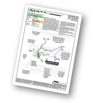
Langholm - Ewes Water - River Esk - Whita Hill - Sir John Malcolm Monument Obelsik - Charlie's Moss - Hugh MacDiarmid Memorial - Hillhead - Ewes Water - Langholm
|
Vital Statistics:
| Length: | 10.25 miles (16.5 km) |
| Ascent: | 1,917 ft (584 m) |
| Time: | 5.75 hrs |
| Grade: | |
Route Summary:
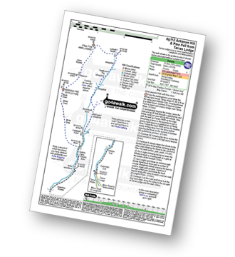
Tarras Lodge - Tarras Water - Coomsfell End - Arkleton Cottage - Greenlea Knowe - Cooms Farm - White Brae - White Cove - Black Cove - Arkleton Hill - Linns Knowe - Pike Fell - Ludsgill Sware - Hawknest Rig - Byrecleuch Burn - Lodgegill Farm - Cooms Farm - Greenlea Knowe - Arkleton Cottage - Coomsfell End - Tarras Lodge
|
Vital Statistics:
| Length: | 14.75 miles (23.5 km) |
| Ascent: | 2,609 ft (795 m) |
| Time: | 8 hrs |
| Grade: | |
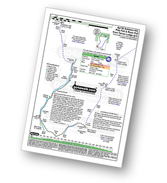
Route Summary:
Tarras Lodge - Tarras Water - Arkleton Cottage - Greenlea Knowe - Cooms Farm - White Brae - White Cove - Black Cove - Arkleton Hill - Linns Knowe - Pike Fell - Ludsgill Sware - Watch Knowe - Scawd Bank - The Pikes - Hartsgarth Fell - Roan Fell - Millstone Edge (Roan Fell) - Watch Hill - Strait Hill - Cooms Fell - Black Edge - Watch Crags - Loch Knowe - Burrowstown Moss - Perter Rig - Tarras Lodge
|
Vital Statistics:
| Length: | 8.75 miles (14 km) |
| Ascent: | 3,236 ft (986 m) |
| Time: | 6½ hrs |
| Grade: | |
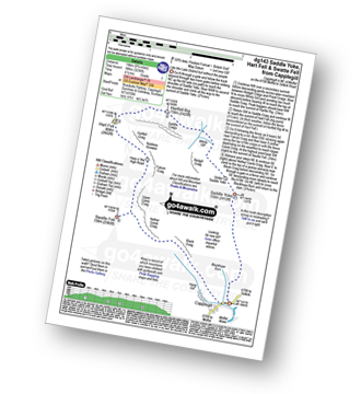
Route Summary:
Capplegill - Blackhope Burn - Saddle Yoke - Under Saddle Yoke - Whirly Gill - Saddle Craigs - Harfell Rig - Hart Fell (Moffat) - Hartfell Craig - Falcon Craig - Upper Comb Craig - Swatte Fell - Nether Comb Craig - Black Craig - Hang Burn - Hang Gill - Capplegill
|
Vital Statistics:
| Length: | 13.75 miles (22 km) |
| Ascent: | 1,861 ft (567 m) |
| Time: | 6.75 hrs |
| Grade: | |

Route Summary:
Tarras Lodge - Tarras Water - Coomsfell End - Arkleton Cottage - Greenlea Knowe - Cooms Farm - Lodgegill Farm - Byrecleuch Burn - Hawknest Rig - Ludsgill Sware - Watch Knowe - Scawd Bank - The Pikes - Hartsgarth Fell - Roan Fell - Millstone Edge (Roan Fell) - Watch Hill - Strait Hill - Cooms Fell - Black Edge - Watch Crags - Loch Knowe - Burrowstown Moss - Perter Rig - Tarras Lodge
|
Vital Statistics:
| Length: | 7.5 miles (12 km) |
| Ascent: | 1,699 ft (518 m) |
| Time: | 4½ hrs |
| Grade: | |
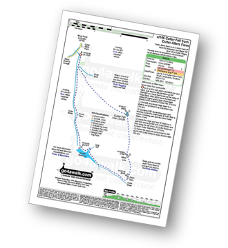
Route Summary:
Culter Allers Farm - Culter Fell - Moss Law - Holm Nick - Culter Water - Coulter Reservoir - Culter Waterhead - Culter Allers Farm
|
Vital Statistics:
| Length: | 12.25 miles (19.5 km) |
| Ascent: | 3,305 ft (1,007 m) |
| Time: | 7.75 hrs |
| Grade: | |

Route Summary:
Culter Allers Farm - Culter Fell - Moss Law - Holm Nick - Gathersnow Hill - Hillshaw Head - Coomb Dod - Dod Hill - Hudderstone - Lea Gill - Culter Water - Culter Allers Farm
See this list of walks, routes & maps in:
Grade Order | Length Order | Time Order | Walk Number or Start Location Order
NB. To reverse (toggle) this order, click Grade Order again


