18 easy-to-follow walk route maps of all grades in the Loch Lomond and The Trossachs to Loch Tay region of Scotland
Eighteen easy-to-follow walk route maps of all grades in the Loch Lomond and The Trossachs to Loch Tay region of Scotland in Walk Grade Order
Loch Lomond and The Trossachs to Loch Tay is the area enclosed by an imaginary line connecting:
- Loch Awe to Ballinluig via the A85 through Dalmally, Inverlochy, Tyndrum & Crianlarich, the A85 through Glen Dochart and then the A827 through Killin, Loch Tay, Kenmore & Aberfeldy to the North
- Ballinluig to Perth via the A9 through Strath Tay to the East
- Perth to Stirling via the A9 through Auchterarder, Greenloaning & Dumblane to the South-East
- Stirling to the Firth of Clyde via the A811 through Kippen & Drymen and then the A812 through Alexandria & Dumbarton to the South
- The Firth of Clyde to Loch Awe via Loch Long to Arrochar, the A83 to Inveraray through Rest and be Thankful and then the A819 to the A85 through Glen Aray & Tullich to the West
Tap/mouse over a coloured circle (1-3 easy walks, 4-6 moderate walks, 7-9 hard walks) and click to select.
Not familiar with the Loch Lomond and The Trossachs to Loch Tay region of Scotland?
See these 18 walks in Loch Lomond and The Trossachs to Loch Tay on an interactive Google Map
See this list of walks, routes & maps in:
Grade Order | Length Order | Time Order | Walk Number or Start Location Order
NB. To reverse (toggle) this order, click Grade Order again
   |
Vital Statistics:
| Length: | 8.75 miles (14 km) |
| Ascent: | 3,499 ft (1,051 m) |
| Time: | 6.75 hrs |
| Grade: |  |

Route Summary:
Arrochar - Loch Long - Ardgarten Forest - Allt a' Bhalachain - Narnain Boulders - Core a' Bhalachain - Lochan a' Chlaidheimh - Bealach A Mhaim - Beinn Ime - Bealach A Mhaim - Lochan a' Chlaidheimh - Core a' Bhalachain - Narnain Boulders - Allt a' Bhalachain - Ardgarten Forest - Arrochar
|
Vital Statistics:
| Length: | 6 miles (9.5 km) |
| Ascent: | 3,216 ft (980 m) |
| Time: | 5½ hrs |
| Grade: |  |

Route Summary:
Arrochar - Loch Long - Argyle Forest - Creag An Fhithich - Cruach Nam Miseag - The Spearhead - Beinn Narnain - Yawning Crags - Bealach A Mhaim - Lochan a' Chlaidheimh - Core a' Bhalachain - Narnain Boulders - Allt a' Bhalachain - Andgarten Forest - Loch Long - Arrochar
|
Vital Statistics:
| Length: | 9 miles (14.5 km) |
| Ascent: | 3,502 ft (1,067 m) |
| Time: | 6.75 hrs |
| Grade: | |

Route Summary:
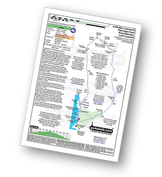
Inveruglas Power Station - Loch Lomond - A82 - Inveruglas Water - Loch Sloy Access Road - Lag Dubh - Ben Vorlich (The Arrochar Alps) - Ben Vorlich (The Arrochar Alps) (North Top) - Lag Dubh - Loch Sloy Access Road - Inveruglas - Loch Lomond.
|
Vital Statistics:
| Length: | 7.5 miles (12 km) |
| Ascent: | 3,101 ft (945 m) |
| Time: | 6 hrs |
| Grade: | |
Route Summary:
Inveruglas Power Station - Loch Lomond - Loch Sloy Hydro Electric Sub-station - Inveruglas Water - Coiregrogain - Ben Vane - Coiregrogain - Inveruglas Water - Loch Sloy Hydro Electric Sub-station - Inveruglas Power Station - Loch Lomond.
|
Vital Statistics:
| Length: | 7.5 miles (11.5 km) |
| Ascent: | 3,344 ft (1,019 m) |
| Time: | 6 hrs |
| Grade: | |

Route Summary:
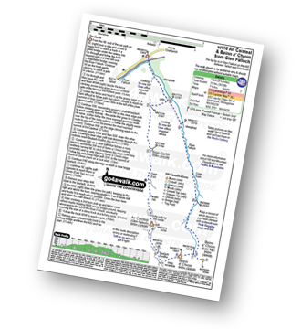
Arrochar - Loch Long - Argyll Forest Park - Adgarten Forest - Allt a' Bhalachain - Narnain Boulders - The Cobbler (Ben Arthur) (NE Top) - The Cobbler (Ben Arthur) - Lochan a' Chlaidheimh - Coire a' Bhalachain - Narnain Boulders - Allt a' Bhalachain - Adgarten Forest - Argyll Forest Park - Arrochar - Loch Long.
|
Vital Statistics:
| Length: | 7.5 miles (12 km) |
| Ascent: | 3,426 ft (1,044 m) |
| Time: | 6.25 hrs |
| Grade: | |
Route Summary:
Rowardennan - Loch Lomond - Sron Aonaich - Ben Lomond - Ptarmigan - Tom Fithich - The West Highland Way - Rowardennen - Loch Lomond.
|
Vital Statistics:
| Length: | 1.5 miles (2.5 km) |
| Ascent: | 542 ft (165 m) |
| Time: | 1.25 hrs |
| Grade: |  |

Route Summary:
Inversnaid - Inversnaid Hotel - Arklet Falls - Loch Lomond - The West Highland Way - Leacainn Lasgair - Cladachbeag - Inversnaid Hotel - Inversnaid
|
Vital Statistics:
| Length: | 6.25 miles (10 km) |
| Ascent: | 4,506 ft (459 m) |
| Time: | 4 hrs |
| Grade: |  |
Route Summary:
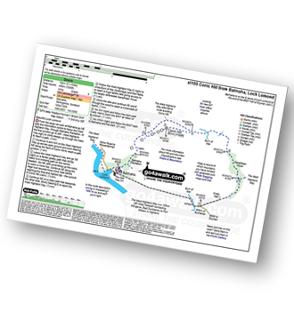
Balmaha - The West Highland Way - Conic Hill - Burn of Mar - Garadhban Wood - Creity Hall - Milton of Buchanan - Balmaha
|
Vital Statistics:
| Length: | 7.75 miles (12.5 km) |
| Ascent: | 3,180 ft (969 m) |
| Time: | 6 hrs |
| Grade: | |

Route Summary:
Rowardennan - Loch Lomond - Sron Aonaich - Ben Lomond - Sron Aonaich - The West Highland Way - Rowardennen - Loch Lomond.
|
Vital Statistics:
| Length: | 7 miles (11 km) |
| Ascent: | 2,534 ft (772 m) |
| Time: | 5 hrs |
| Grade: | |
|
Vital Statistics:
| Length: | 9.5 miles (15 km) |
| Ascent: | 3,673 ft (1,119 m) |
| Time: | 7.25 hrs |
| Grade: | |
Route Summary:
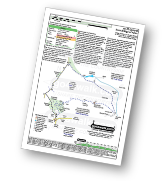
Glen Falloch - River Falloch - Sron Garbh - Coire Elch - Twistin Hill - The Castle - An Caisteal (Glen Falloch) - Bealach Buidhe - Beinn a' Chroin - Beinn a' Chroin (East Top) - River Falloch - Core Earb - Glen Falloch
|
Vital Statistics:
| Length: | 6.25 miles (10 km) |
| Ascent: | 1,848 ft (563 m) |
| Time: | 4.25 hrs |
| Grade: | |

Route Summary:
Strathyre - River Balvag - Strathyre Forest - An Sidhean - Beinn an t-Sidhein - Beinn Luidh - Buachaille Breige - Stroneslaney - Baileful - Strathyre
|
Vital Statistics:
| Length: | 2.75 miles (4.5 km) |
| Ascent: | 627 ft (191 m) |
| Time: | 1.75 hrs |
| Grade: |  |

|
Vital Statistics:
| Length: | 2.5 miles (4 km) |
| Ascent: | 1,329 ft (405 m) |
| Time: | 2½ hrs |
| Grade: |  |

Route Summary:
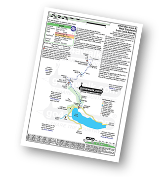
Ben A'an Forestry Commission Car Park - Loch Achray - The Trossachs - Woodland - Ben A'an - Woodland - Ben A'an Forestry Commission Car Park - Loch Achray.
|
Vital Statistics:
| Length: | 7.25 miles (11.5 km) |
| Ascent: | 1,894 ft (577 m) |
| Time: | 4½ hrs |
| Grade: | |
Route Summary:
Kirk Logie - Bridge of Allan - Yellow Craig Wood - Dumyat - Glen Menstrie - Lossburn Reservoir - Kirk Logie - Bridge of Allan.
|
Vital Statistics:
| Length: | 6.25 miles (9.5 km) |
| Ascent: | 2,681 ft (817 m) |
| Time: | 5 hrs |
| Grade: | |

Route Summary:
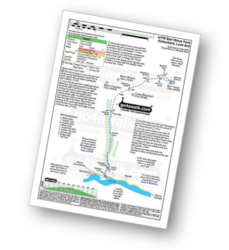
Falls of Leny - Car Park NW of Falls of Leny - The Rob Roy Way - Garbh Uisge - Coireachchrombie - Stank - Stank Glen - Bealach Nan Corp - Coire na Fuaire - Gualainn Buidhe - Mullach Buidhem - Ben Ledi - Meal Odher - Creag Ghornm Car Park - Falls of Leny
|
Vital Statistics:
| Length: | 5.25 miles (8.5 km) |
| Ascent: | 1,165 ft (355 m) |
| Time: | 3½ hrs |
| Grade: |  |
Route Summary:
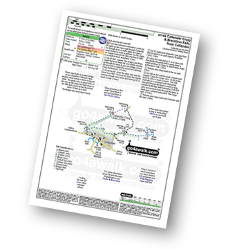
Callander - Callander Craig - Bracklinn Falls Car Park - Keltie Water - Bracklinn Falls - Woodland - Callander
|
Vital Statistics:
| Length: | 5.25 miles (8.5 km) |
| Ascent: | 2,117 ft (645 m) |
| Time: | 4 hrs |
| Grade: | |
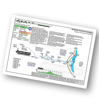
Route Summary:
Ben A'an Forestry Commision Car Park - Loch Achray - The Trossachs - Woodland - Ben A'an - Meall Gainmheich - Ben A'an Forestry Commision Car Park - Loch Achray.
See this list of walks, routes & maps in:
Grade Order | Length Order | Time Order | Walk Number or Start Location Order
NB. To reverse (toggle) this order, click Grade Order again


