Four easy to follow walk route maps from Hawes in the Yorkshire Dales, North Yorkshire, England
Scroll down the list of walks below & click on each walk title (in blue) to locate it on the map above.
   |
Vital Statistics:
| Length: | 3.75 miles (6 km) |
| Ascent: | 295ft (90m) |
| Time: | 1.75hrs |
| Grade: |  |
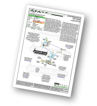
Route Summary:
Hawes - The Pennine Way - The Herriot Way - Haylands Bridge - The River Ure - Hardraw - Hardraw Force - West House - Simonstone Hotel - Sedbusk - Hawes
|
Vital Statistics:
| Length: | 8.5 miles (13.5 km) |
| Ascent: | 1,030ft (314m) |
| Time: | 4 hrs |
| Grade: |  |
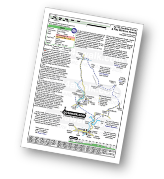
Route Summary:
Hawes - The Pennine Way - The Herriot Way - Haylands Bridge - The River Ure - Hardraw - Hardraw Force - Shaw Gill Wood - Simonstone Hotel - High Shaw - Shivery Gill - Pike Hill - Abbotside Common - Low Clint - High Pasture Gate - Shutt Lane - Sedbusk - Hawes
|
Vital Statistics:
| Length: | 12 miles (19 km) |
| Ascent: | 1,956ft (596m) |
| Time: | 6.25hrs |
| Grade: |  |
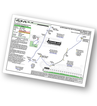
Route Summary:
Hawes - The Pennine Way - The Herriot Way - Gayle - Gaudy Lane - Rottonstone Hill - Ten End Peat Ground - West Cam Road - Dodd Fell Hill - North Gate - West Duerley Pasture - Cam High Road - Howgate Head - Drumaldrace (Wether Fell) - Wether Fell - Gayle - Hawes
|
Vital Statistics:
| Length: | 13.75 miles (22 km) |
| Ascent: | 2,330ft (710m) |
| Time: | 7.25hrs |
| Grade: |  |
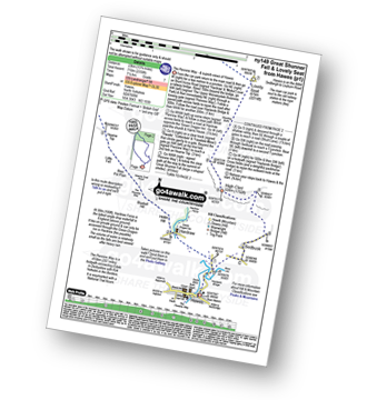
Route Summary:
Hawes - The Pennine Way - The Herriot Way - Haylands Bridge - The River Ure - Hardraw - Hardraw Force - Hearne Coal Road - Hollin Hill - Bluebell Hill - Blea Pot Plain - Hearn Top - Bleak Haw - Hearne Head - Great Shunner Fell - Little Shunner Fell - Pickersett Mea - Fossdale Moss - Grimy Gutter - Lovely Seat - Coal Gill Hags - Abbotside Common - High Clint - High Pasture Gate - Shutt Lane - Sedbusk - Hawes

To contribute to go4awalk.com or to contact us about anything at all - see Talk To Us. For help see Help.
go4awalk.com and go4awalk.co.uk are registered trademarks of TMDH Limited.
Copyright © 2000-2024 TMDH Limited. All rights reserved.
Copyright | Terms & Conditions | Privacy Statement
A - Z
Walks
Home
Log On/Accounts
Photo Gallery
Walk Ideas and Collections
Fell Facts
Places to Stay
Hill Skills
Walking Questions and Answers
Your Stories
News
Competitions
Product Reviews/Gear Tests
Walking Gear Guides
Peaks and Mountains
Peak Bagging
Find New Walking Friends
Camping
GPS Waypoints for Walking
Walk Search
Talk to us
go4awalk.com Help
Free example walks
Newsletter


