Ten easy to follow walk route maps from Hope in the Peak District, Derbyshire, England
Scroll down the list of walks below & click on each walk title (in blue) to locate it on the map above.
   |
Vital Statistics:
| Length: | 5.75 miles (9 km) |
| Ascent: | 971ft (296m) |
| Time: | 3 hrs |
| Grade: |  |
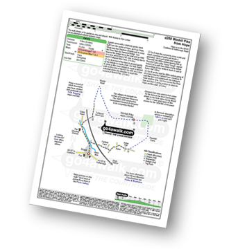
Route Summary:
Hope - Hope Bank - Wooler Knoll - Winhill Plantation - Winhill Pike (Win Hill) - Thornhill - Aston - Hope
|
Vital Statistics:
| Length: | 9.5 miles (15 km) |
| Ascent: | 1,588ft (484m) |
| Time: | 5 hrs |
| Grade: |  |
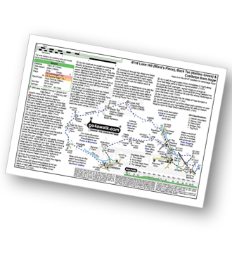
Route Summary:
Hope - Townhead Bridge - Losehill End - Lose Hill (Ward's Piece) - Back Tor (Hollins Cross) - Barker Bank - Hollins Cross - Mam Tor Farm - Knowlgate Farm - Odin Sitch - Castleton - Hollowford Centre - Spring House Farm - Hope
|
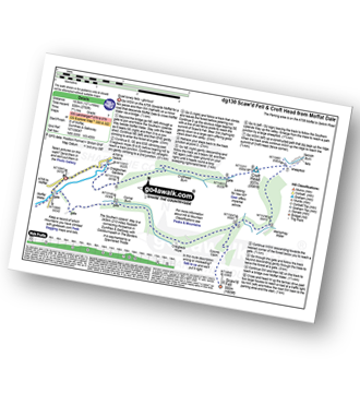
Vital Statistics:
| Length: | 8.25 miles (13 km) |
| Ascent: | 1,532ft (467m) |
| Time: | 4½ hrs |
| Grade: | |
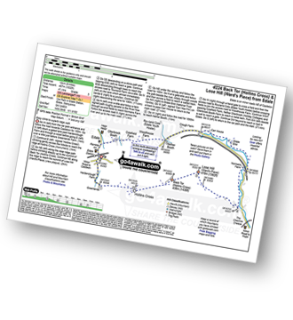
Route Summary:
Edale - Small Clough - Hardenclough Farm - Greenlands - Hollins Cross - Back Tor (Hollins Cross) - Lose Hill (Ward's Piece) - Hope - The River Noe - Normans Farm - Edale End - Carr House - Nether Booth - Ollerbrook Booth - The Vale of Edale - Edale
|
Vital Statistics:
| Length: | 10.25 miles (16.5 km) |
| Ascent: | 1,585ft (483m) |
| Time: | 5.25hrs |
| Grade: |  |
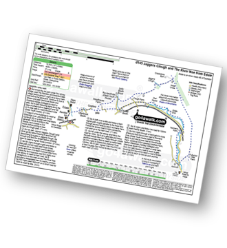
Route Summary:
Edale - Ollerbrook Booth - Rowland Cote (Edale Youth Hostel) - Lady Booth Brook - Nether Moor - Backside Wood - Jaggers Clough - Hope Cross - Fulwood Stile Farm. Hope - The River Noe - Normans Farm - Edale End - Carr House - Nether Booth - Ollerbrook Booth - The Vale of Edale - Edale
|
Vital Statistics:
| Length: | 9.75 miles (15.5 km) |
| Ascent: | 2,206ft (672m) |
| Time: | 5.75hrs |
| Grade: | |
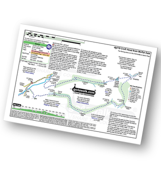
Route Summary:
Parking Area A708 NE of Moffat - Moffat Water - Moffat Dale - The Southern Upland Way - Cornal Burn - Craigbeck Hope - Eskdalemuir - Wamphrey Burn - Sheepfold - Slecoth Burn - Croft Head - Corfthead Burn - Craiglochan Gardens - Parking Area.
|
Vital Statistics:
| Length: | 7.25 miles (11.5 km) |
| Ascent: | 3,086ft (941m) |
| Time: | 5½ hrs |
| Grade: | |
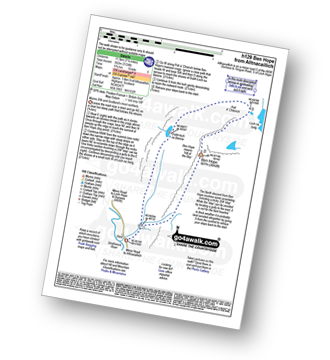
Route Summary:
Strath More - Muiseal - Allt a' Muiseal - Leitir Muiseal - Ben Hope - Leitir Muiseal - Allt a' Muiseal - Muiseal - Strath More
|
Vital Statistics:
| Length: | 8.5 miles (13.5 km) |
| Ascent: | 2,114ft (644m) |
| Time: | 5½ hrs |
| Grade: | |
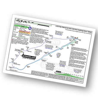
Route Summary:
Harthope Burn Valley - Hawsen Burn Parking Area - New Burn - Scald Hill - The Cheviot - Cairn Hill (Scotsmans Cairn) - Harthope Burn - Hrthope Linn - Langleeford Hope - Cat Loup - Ray Burn - Langleeford Farm - Hawsen Burn Parking Area.
|
Vital Statistics:
| Length: | 12.25 miles (19.5 km) |
| Ascent: | 2,750ft (838m) |
| Time: | 7½ hrs |
| Grade: |  |
Route Summary:
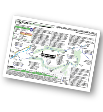
Parking Area A708 NE of Moffat - Moffat Water - Moffat Dale - The Southern Upland Way - Cornal Burn - Craigbeck Hope - Coomb Cairn - Scaw'd Fell - Eskdalemuir - Wamphrey Burn - Sheepfold - Slecoth Burn - Croft Head - Corfthead Burn - Craiglochan Gardens - Parking Area.
|
Vital Statistics:
| Length: | 10.5 miles (17 km) |
| Ascent: | 2,614ft (797m) |
| Time: | 6½ hrs |
| Grade: | |

Route Summary:
Harthope Burn Valley - Cold Law - Broadhope Hill - Scald Hill - The Cheviot - The Pennine Way - Harthope Burn - Langleeford Hope - Langleeford - Harthope Burn Valley
|
Vital Statistics:
| Length: | 14.5 miles (23 km) |
| Ascent: | 3,781ft (1,152m) |
| Time: | 9 hrs |
| Grade: |  |
Route Summary:
Parking Area A708 NE of Moffat - Moffat Water - Moffat Dale - The Southern Upland Way - Cornal Burn - Craigbeck Hope - Coomb Cairn - Scaw'd Fell - Eskdalemuir - Wamphrey Burn - Sheepfold - Slecoth Burn - Loch Fell - Croft Head - Corfthead Burn - Craiglochan Gardens - Parking Area.

To contribute to go4awalk.com or to contact us about anything at all - see Talk To Us. For help see Help.
go4awalk.com and go4awalk.co.uk are registered trademarks of TMDH Limited.
Copyright © 2000-2024 TMDH Limited. All rights reserved.
Copyright | Terms & Conditions | Privacy Statement
A - Z
Walks
Home
Log On/Accounts
Photo Gallery
Walk Ideas and Collections
Fell Facts
Places to Stay
Hill Skills
Walking Questions and Answers
Your Stories
News
Competitions
Product Reviews/Gear Tests
Walking Gear Guides
Peaks and Mountains
Peak Bagging
Find New Walking Friends
Camping
GPS Waypoints for Walking
Walk Search
Talk to us
go4awalk.com Help
Free example walks
Newsletter


