Nine easy to follow walk route maps from the village of Eskdale in the southern Lake District, Cumbria, England
   |
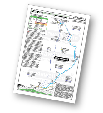
Vital Statistics:
| Length: | 6.25 miles (10 km) |
| Ascent: | 601ft (183m) |
| Time: | 3 hrs |
| Grade: |  |
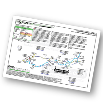
Route Summary:
Eskdale - Boot - Dalegarth Station - River Esk - Doctor Bridge - Jubilee Bridge - Hardknott Pass - Brotherilkeld - Taw House Farm - Boot - Eskdale
|
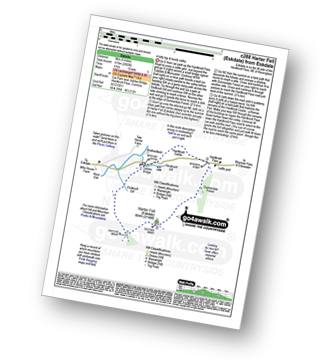
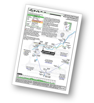
Vital Statistics:
| Length: | 6.25 miles (10 km) |
| Ascent: | 1,756ft (535m) |
| Time: | 4 hrs |
| Grade: |  |
Route Summary:
Eskdale - Jubilee Bridge - Hardknott Pass - Hardknott Castle. (Roman Fort) - Hardknott Pass - Hard Knott - Yew Bank - Lingcove Beck - Lingcove Bridge - Great Moss - River Esk - Jubilee Bridge - Eskdale
|
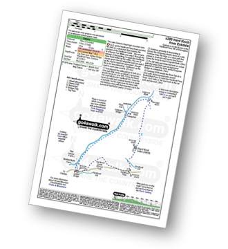
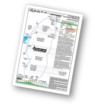
Vital Statistics:
| Length: | 5 miles (8 km) |
| Ascent: | 2,002ft (610m) |
| Time: | 4 hrs |
| Grade: | |
Route Summary:
Eskdale - Jubilee Bridge - Eskdale - Dobknott Gill - Spothow Gill - Harter Fell (Eskdale) - Dunnerdale Forest - Hardknott Pass - Hardknott Castle (Roman Fort) - Jubilee Bridge - Eskdale
|
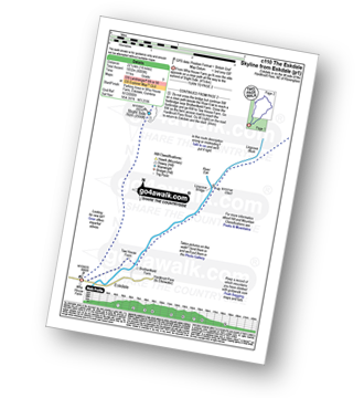
Vital Statistics:
| Length: | 8.5 miles (13.5 km) |
| Ascent: | 1,953ft (595m) |
| Time: | 5 hrs |
| Grade: |  |
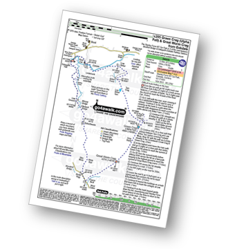
Route Summary:
Stanley Force NT Car Park - Eskdale - Boot - River Esk - Low Birker - Crook Crag - Green Crag (Ulpha Fell) - Great Worm Crag - Brown Rigg - Sike Moss - Birkerthwaite - Low Ground Cottages - Stanley Force - River Esk - Stanley Force NT Car Park - Eskdale
|
Vital Statistics:
| Length: | 10 miles (16 km) |
| Ascent: | 3,428ft (1,045m) |
| Time: | 7 hrs |
| Grade: |  |
Route Summary:
Eskdale - Wha House Farm - Hare Crag - Quagrigg Moss - Slight Side - Sca Fell - Symonds Knott - Foxes Tarn - Cam Spout Crag - River Esk - Great Moss - Lingcove Bridge - Brotherilkeld - Hardknott Pass - Eskdale
|
Vital Statistics:
| Length: | 10 miles (16 km) |
| Ascent: | 3,401ft (1,037m) |
| Time: | 7 hrs |
| Grade: | |
Route Summary:
Eskdale - Wha House Farm - Hare Crag - Goat Crag - Dawsonground Crags - Cat Crag - Quagrigg Moss - Slight Side - Sca Fell - Symonds Knott - Hard Rigg - Burnmoor Tarn - Eel Tarn - Christcliff - Wha House Farm - Eskdale
|
Vital Statistics:
| Length: | 12.25 miles (19.5 km) |
| Ascent: | 3,568ft (1,087m) |
| Time: | 8 hrs |
| Grade: |  |
Route Summary:
Eskdale - The Woolpack Inn - Doctor Bridge - Low Birker - Birker Force - Low Birker Tarn - Green Crag (Ulpha Fell) - Crook Crag - Harter Fell (Eskdale) - Dunnerdale Forest - Hardknott Pass - Hardknott Gill - Hard Knott - Yew Bank - Lingcove Beck - Lingcove Bridge - Great Moss - Brotherilkeld - Taw House Farm - Wha House Farm - The River Esk - The Woolpack Inn - Eskdale
|
Vital Statistics:
| Length: | 14 miles (22.5 km) |
| Ascent: | 6,009ft (1,832m) |
| Time: | 9 hrs |
| Grade: |  |
Route Summary:
Eskdale - Wha House Farm - Hare Crag - Quagrigg Moss - Slight Side - Sca Fell - Symonds Knott - Mickledore - Scafell Pike - Broad Crag - Ill Crag - Great End - Esk Hause - Esk Pike - Ore Gap - Bow Fell (Bowfell) (North Top) - Bow Fell (Bowfell) - Bowfell Buttress - Cambridge Crag - Flat Crag - Climbers' Traverse (optional) - Three Tarns - Great Moss - Brotherikeld - Eskdale
|
Vital Statistics:
| Length: | 13.75 miles (22 km) |
| Ascent: | 4,982ft (1,519m) |
| Time: | 10 hrs |
| Grade: | |

Route Summary:
Eskdale - Wha House Farm - Hare Crag - Quagrigg Moss - Slight Side - Sca Fell - Symonds Knott - Scafell Pike - Broad Crag - Ill Crag - Great End - Esk Hause - Lingcove Bridge - Great Moss - Eskdale

To contribute to go4awalk.com or to contact us about anything at all - see Talk To Us. For help see Help.
go4awalk.com and go4awalk.co.uk are registered trademarks of TMDH Limited.
Copyright © 2000-2024 TMDH Limited. All rights reserved.
Copyright | Terms & Conditions | Privacy Statement
A - Z
Walks
Home
Log On/Accounts
Photo Gallery
Walk Ideas and Collections
Fell Facts
Places to Stay
Hill Skills
Walking Questions and Answers
Your Stories
News
Competitions
Product Reviews/Gear Tests
Walking Gear Guides
Peaks and Mountains
Peak Bagging
Find New Walking Friends
Camping
GPS Waypoints for Walking
Walk Search
Talk to us
go4awalk.com Help
Free example walks
Newsletter


