16 easy to follow walk route maps of all grades on OS Explorer Map 340 Holy Island & Bamburgh
Sixteen easy-to-follow hand-crafted printable walk route maps that are wholly on or partly on OS Explorer Map 340 Holy Island & Bamburgh to suit all levels of fitness and ability.
Tap/mouse over a coloured circle (1-3 easy walks, 4-6 moderate walks, 7-9 hard walks) and click to select.
You can use these checkboxes to show only the grades of walk you are interested in:-
Sixteen easy-to-follow walk route maps of all grades on OS Explorer Map 340 Holy Island & Bamburgh in Walk Grade Order
Scroll down the list of walks below & click on each walk title (in blue) to locate it on the map above.
See this list of walks, routes & maps in:
Grade Order |
Length Order |
Time Order |
Walk Number or Start Location Order
NB. To reverse (toggle) this order, click Grade Order again
   |
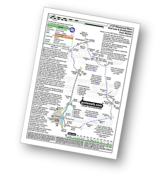
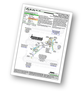
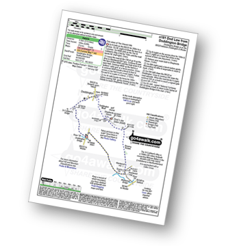
Vital Statistics:
| Length: | 5 miles (8 km) |
| Ascent: | 180ft (55m) |
| Time: | 2 hrs |
| Grade: |  |
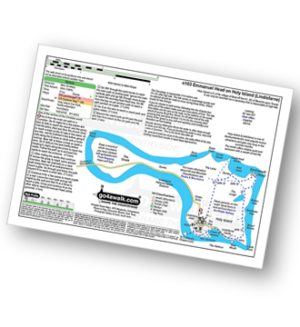
Route Summary:
Holy Island (Lindisfarne) Car Park - The Priory - The St Cuthbert's Way - Lindisfarne Castle - Emannuel Head - Holy Island (Lindisfarne) Car Park
|
Vital Statistics:
| Length: | 7.5 miles (12 km) |
| Ascent: | 1,257ft (383m) |
| Time: | 4½ hrs |
| Grade: |  |
Route Summary:
Wooler - The St Cuthbert's Way - Waud House - Kenterdale Hill - Wooler Common - Switcher Wood - Earlhillhead Farm - Carey Burn - Careyburn Bridge - Harthope Burn - Colgate Water (High Level Route) - Happy Valley - Middleton Old Town - North Middleton - Colgate Mill - Colgate Water - Earle Mill - Wooler Water - Wooler
|
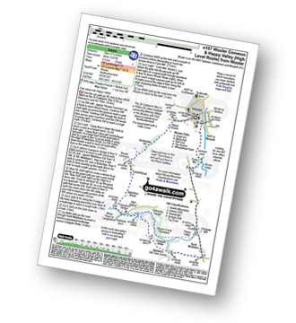
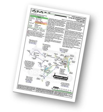
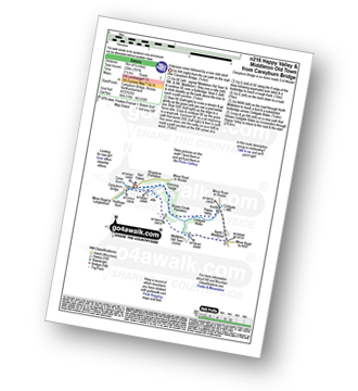
Vital Statistics:
| Length: | 4.75 miles (7.5 km) |
| Ascent: | 985ft (300m) |
| Time: | 2.75hrs |
| Grade: |  |
Route Summary:
Wooler - Gallowlaw Gallowlaw Hill - Humbleton - Humbleton Hill - Brown's Law - Wooler Common And Woodland Park - Wooler
|
Vital Statistics:
| Length: | 5.25 miles (8.5 km) |
| Ascent: | 512ft (156m) |
| Time: | 2½ hrs |
| Grade: | |
Route Summary:
Bamburgh - Bamburgh Castle - The Wynding - Harkess Rocks - Bamburgh Lighthouse - Blackrocks Point - Hare Law - Kittling Hill - Budle Point - Heather Cottages - Kiln Point - Budle - East Hill - Warren Camping and Caravan Park - Drawkiln Hill - Shada Plantation - Gallinheugh Bank - Bamburgh
|
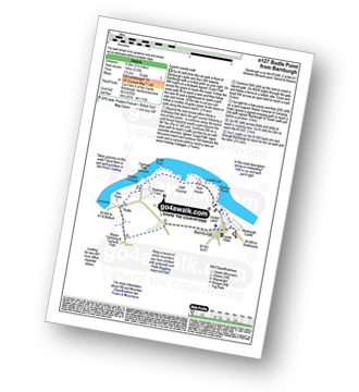
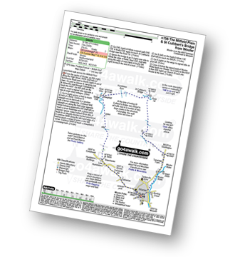
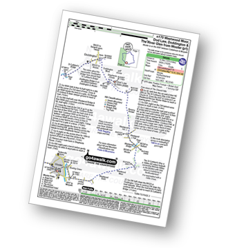
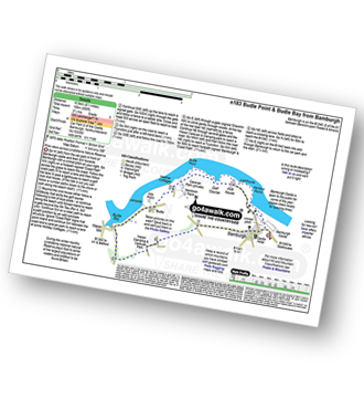
Vital Statistics:
| Length: | 8.5 miles (13.5 km) |
| Ascent: | 1,093ft (333m) |
| Time: | 4.25hrs |
| Grade: |  |
Route Summary:
Wooler - The St Cuthbert's Way - Weetwood Bank - Weetwood Moor - River Till - Weetwood Bridge - Weetwood Hall - Weetwood Hill - Broomy Knowe - Shepherds House - Dod Law - Doddington Moor - Doddington - Milfield Plain - Doddington Bridge - Turvelaws Farm - Wooler
|
Vital Statistics:
| Length: | 5.75 miles (9 km) |
| Ascent: | 1,214ft (370m) |
| Time: | 3½ hrs |
| Grade: | |
Route Summary:
Wooler - Gallowlaw Gallowlaw Hill - Humbleton - Humbleton Hill - Brown's Law - Wooler Common and Woodland Park - The St Cuthbert's Way - Kenterdale Hill - Waud House - Wooler
|
Vital Statistics:
| Length: | 6.5 miles (10.5 km) |
| Ascent: | 1,043ft (318m) |
| Time: | 3½ hrs |
| Grade: | |
Route Summary:
Wooler - The St Cuthbert's Way - Waud House - Kenterdale Hill - Wooler Common - Switcher Wood - Earlhillhead Farm - Carey Burn - Careyburn Bridge - Harthope Burn - Colgate Water (Low Level Route) - Skirl Naked - Grimping Haugh - Broom Crook Plantation - Happy Valley - Careyburn Bridge - Colgate Mill - Earle Mill - Wooler Water - Wooler
|
Vital Statistics:
| Length: | 6.5 miles (10.5 km) |
| Ascent: | 240ft (73m) |
| Time: | 2.75hrs |
| Grade: |  |
Route Summary:
Wooler - Gallowlaw Gallowlaw Hill - Low Humbleton - Bowchester - The River Glen - Bridge End - Humbleton Burn Milfield Plain - St Cuthbert's Bridge - Turvelaws Farm - Wooler
|
Vital Statistics:
| Length: | 6.25 miles (10 km) |
| Ascent: | 1,037ft (316m) |
| Time: | 3½ hrs |
| Grade: | |
Route Summary:
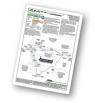
Hepburn Wood - Hepburn Crags - Ros Castle (Ross Castle) - Hepburn Moor - Botany Cottage - Quarryhouse Moor - Blawearie - Hepburn Crags - Hepburn Wood
|
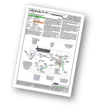
Vital Statistics:
| Length: | 3.25 miles (5 km) |
| Ascent: | 525ft (160m) |
| Time: | 1.75hrs |
| Grade: | |
Route Summary:
Wooler - The St Cuthbert's Way - Waud House - Kenterdale Hill - Wooler Common and Woodland Park - Wooler
|
Vital Statistics:
| Length: | 10.25 miles (16.5 km) |
| Ascent: | 1,182ft (360m) |
| Time: | 5 hrs |
| Grade: | |
Route Summary:
Wooler - The St Cuthbert's Way - Weetwood Bank - Weetwood Moor - River Till - Weetwood Bridge - Weetwood Hall - Weetwood Hill - Broomy Knowe - Shepherds House - Dod Law (Doddington Moor) - Doddington Moor - Doddington - River Till - St Cuthbert's Bridge - Milfield Plain - River Glen - Bridge End - Bowchester - Low Humbleton - Gallowlaw Hill - Gallowlaw - Wooler
|
Vital Statistics:
| Length: | 8.5 miles (13.5 km) |
| Ascent: | 988ft (301m) |
| Time: | 4.25hrs |
| Grade: | |
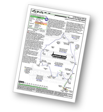
Route Summary:
Eglingham - Tarry - Eglingham Moor - Curleheugh - Hare Crag - Ceteran Hill - Ceteran Meadows Moss - Blawearie - Bewick Moor - Tick Law - Harehope Hill - Harehope Farm - Ticket Hill - Eglingham
|
Vital Statistics:
| Length: | 5.5 miles (8.5 km) |
| Ascent: | 620ft (189m) |
| Time: | 2.75hrs |
| Grade: | |
Route Summary:
Doddington Bridge - Quarry Hill - Weetwood Hill - Broomy Knowe - Shepherds House - Dod Law - Doddington Moor - Doddington - Milfield Plain - River Till - Doddington Bridge
|
Vital Statistics:
| Length: | 6.5 miles (10.5 km) |
| Ascent: | 650ft (198m) |
| Time: | 3½ hrs |
| Grade: | |
Route Summary:
Bamburgh - Bamburgh Castle - The Wynding - Harkess Rocks - Bamburgh Lighthouse - Blackrocks Point - Hare Law - Kittling Hill - Budle Point - Heather Cottages - Kiln Point - Budle - Budle Bay - Widehoe Haugh - Spindlestone Heaughs - Ladley Worm's Trough - Drawkiln Hill - Warren Camping and Caravan Park - East Hill - Shada Plantation - Gallinheugh Bank - Bamburgh
|
Vital Statistics:
| Length: | 10.75 miles (17 km) |
| Ascent: | 1,746ft (532m) |
| Time: | 5.75hrs |
| Grade: |  |
Route Summary:
Wooler - The St Cuthbert's Way - Waud House - Kenterdale Hill - Wooler Common - Carey Burn - Broadstruthers Burn - Commonburn House - Wackerage Cairn - Tom Tallon's Crag - The St Cuthbert's Way - Gleadscleugh - Akeld Burn - Humbleton - Gallowlaw - Wooler
|
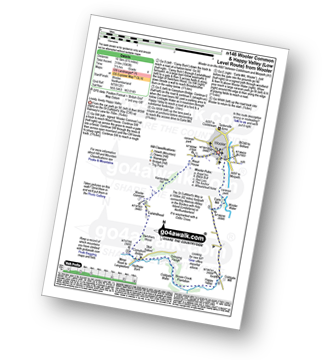
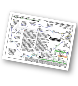
Vital Statistics:
| Length: | 4.5 miles (7 km) |
| Ascent: | 781ft (238m) |
| Time: | 2½ hrs |
| Grade: | |
Route Summary:
Careyburn Bridge - Carey Burn - Harthope Burn - Middleton Old Town - North Middleton - Colgate Mill - Colgate Water (Low Level Route) - Happy Valley - Broom Crook Plantation - Grimping Haugh - Skirl Naked - Careyburn Bridge
See this list of walks, routes & maps in:
Grade Order |
Length Order |
Time Order |
Walk Number or Start Location Order
NB. To reverse (toggle) this order, click Grade Order again
To contribute to go4awalk.com or to contact us about anything at all - see Talk To Us. For help see Help.
go4awalk.com and go4awalk.co.uk are registered trademarks of TMDH Limited.
Copyright © 2000-2024 TMDH Limited. All rights reserved.
Copyright | Terms & Conditions | Privacy Statement
A - Z
Walks
Home
Log On/Accounts
Photo Gallery
Walk Ideas and Collections
Fell Facts
Places to Stay
Hill Skills
Walking Questions and Answers
Your Stories
News
Competitions
Product Reviews/Gear Tests
Walking Gear Guides
Peaks and Mountains
Peak Bagging
Find New Walking Friends
Camping
GPS Waypoints for Walking
Walk Search
Talk to us
go4awalk.com Help
Free example walks
Newsletter


