56 easy to follow walk route maps of all grades on OS Explorer Map OL2 Yorkshire Dales - Southern & Western areas
Fifty-six easy-to-follow hand-crafted printable walk route maps that are wholly on or partly on OS Explorer Map OL2 Yorkshire Dales - Southern & Western areas to suit all levels of fitness and ability.
Tap/mouse over a coloured circle (1-3 easy walks, 4-6 moderate walks, 7-9 hard walks) and click to select.
You can use these checkboxes to show only the grades of walk you are interested in:-
Fifty-six easy-to-follow walk route maps of all grades on OS Explorer Map OL2 Yorkshire Dales - Southern & Western areas in Walk Grade Order
Scroll down the list of walks below & click on each walk title (in blue) to locate it on the map above.
See this list of walks, routes & maps in:
Grade Order |
Length Order |
Time Order |
Walk Number or Start Location Order
NB. To reverse (toggle) this order, click Grade Order again
   |
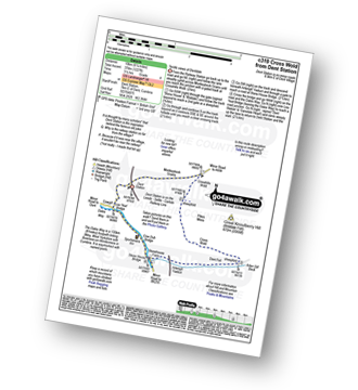
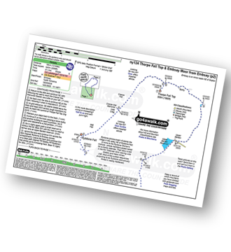
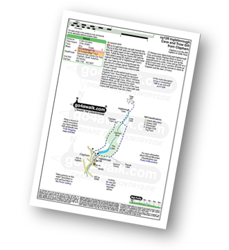
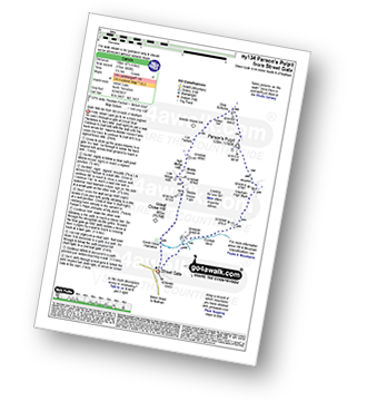
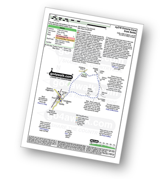
Vital Statistics:
| Length: | 4 miles (6.5 km) |
| Ascent: | 797ft (243m) |
| Time: | 2½ hrs |
| Grade: |  |
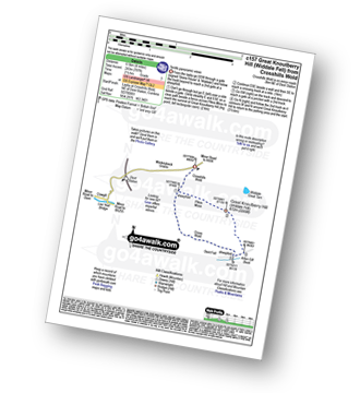
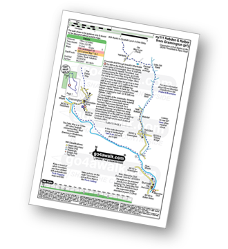
Route Summary:
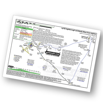
Crosshills Wold (nr Dent Railway Station) - Pikes Moss - Great Knoutberry Hill (Widdale Fell) - Arten Gill Beck - Cross Wold - Crosshills Wold.
|
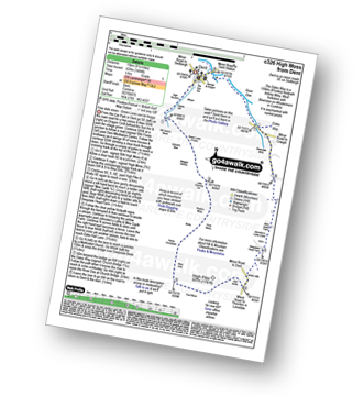
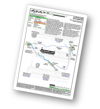
Vital Statistics:
| Length: | 6.25 miles (10 km) |
| Ascent: | 1,548ft (472m) |
| Time: | 4 hrs |
| Grade: |  |
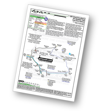
Route Summary:
Dent Railway Station - Crosshills Wold - Pikes Moss - Great Knoutberry Hill (Widdale Fell) - Arten Gill Beck - Dent Fell - The Dales Way - Stone House - Cowgill - Dent Railway Station
|
Vital Statistics:
| Length: | 9 miles (14.5 km) |
| Ascent: | 19,112ft (583m) |
| Time: | 5.25hrs |
| Grade: |  |
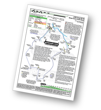
Route Summary:
Dent - Flinter Gill - Crag Hill (Great Coum) - Great Coum - Lancashire County Stone - Blea Gills - Nun House Outrake - The Dales Way - River Dee - Dent
|
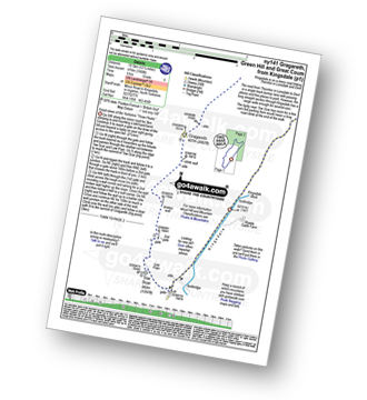
Vital Statistics:
| Length: | 12.25 miles (19.5 km) |
| Ascent: | 2,306ft (703m) |
| Time: | 6.70hrs |
| Grade: |  |
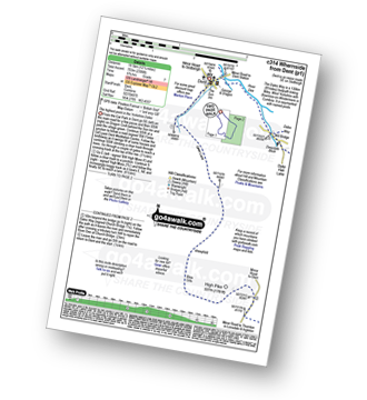
Route Summary:
Dent - Flinter Gill - Green Lane - High Pike - Whernside - Wernside Tarns - Craven Way - Mill Bridge (Deepdale Beck) - The Dales Way - Deepdale Beck - River Dee - Dent
|
Vital Statistics:
| Length: | 6.5 miles (10.5 km) |
| Ascent: | 1,227ft (374m) |
| Time: | 3.75hrs |
| Grade: |  |
Route Summary:
Dent Railway Station - Crosshills Wold - Pikes Moss - Great Knoutberry Hill (Widdale Fell) - Arten Gill Beck - Dent Fell - The Dales Way - Stone House - Cowgill - Dent Railway Station
|
Vital Statistics:
| Length: | 9.5 miles (15 km) |
| Ascent: | 1,404ft (428m) |
| Time: | 5 hrs |
| Grade: | |
Route Summary:
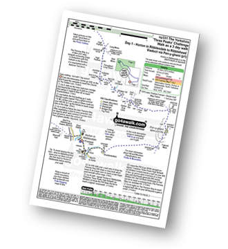
Dent - Flinter Gill - Green Lane - Bill Varry's Moss - Garnet's Man - Megger Stones - Little Coombe Hill - Ralph's Moss - Flow Moss - Robin Constable - High Pike - High Moss - White Shaw - Deepdale Head - Johnston's Lathe - Mire Garth - Dyke Hall Lane - Deepdale Beck - The Dales Way - River Dee - Dent
|
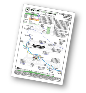
Vital Statistics:
| Length: | 13.5 miles (21.5 km) |
| Ascent: | 2,317ft (706m) |
| Time: | 7.25hrs |
| Grade: | |
Route Summary:
Hodge Bridge - Barbon - Thorn Moor - Eskholme Pike - Castle Knott - Calf Top - Barkin Top - Longbank Peat Moss - Long Bank - Fellside Farm - River Lune - Low Waterside Farm - Middleton Hall Bridge - Stockdale Beck - Applegarth - Borwens - Eller Beck - Barbon - Hodge Bridge
|
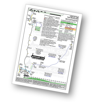
Vital Statistics:
| Length: | 12.75 miles (20.5 km) |
| Ascent: | 1,830ft (558m) |
| Time: | 6½ hrs |
| Grade: | |
Route Summary:
Dent - The Dales Way - Barth Bridge - Long Moor - Aye Gill Pike - Rise Hill - Snaizwold Fell - Cowgill - The Dales Way - Dent
|
Vital Statistics:
| Length: | 18 miles (29 km) |
| Ascent: | 2,945ft (898m) |
| Time: | 9½ hrs |
| Grade: |  |
Route Summary:
Dent - The Dales Way - Barth Bridge - Long Moor - Aye Gill Pike - Rise Hill - Little Snaizwold Fell - Snaizwold Fell - Cowgill Wold Moss - Crosshills Wold - Pikes Moss - Great Knoutberry Hill (Widdale Fell) - Arten Gill Beck - Dent Fell - The Dales Way - Stone House - Cowgill - Dent
|
Vital Statistics:
| Length: | 5.5 miles (8.5 km) |
| Ascent: | 1,004ft (306m) |
| Time: | 3 hrs |
| Grade: | |
Route Summary:
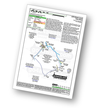
Dent - Flinter Gill - Green Lane - Nun House Outrake - The Dales Way - River Dee - Dent
|
Vital Statistics:
| Length: | 4.75 miles (7.5 km) |
| Ascent: | 984ft (300m) |
| Time: | 3 hrs |
| Grade: | |
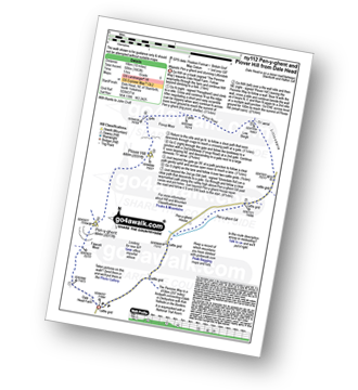
Route Summary:
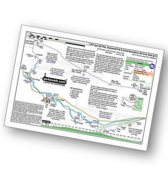
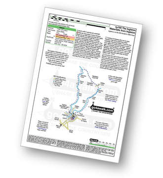
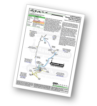
Ingleton - The Ingleton Waterfalls Trail - River Twiss - Swilla Glen - The Money Tree - Helks - Mount - Manor Bridge - Constitution Hill - Pecca Bridge - Pecca Falls - Thornton Force - Raven Ray Bridge - Kingsdale - Twistleton Hall - River Doe - Beezley Falls - Rival Falls - Snow Falls - Ingleton
|
Vital Statistics:
| Length: | 24 miles (38.5 km) |
| Ascent: | 5,297ft (1,614m) |
| Time: | 14 hrs |
| Grade: |  |
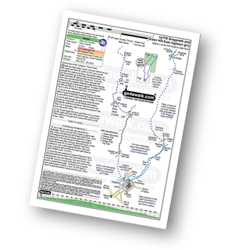
Route Summary:
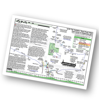
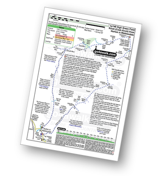
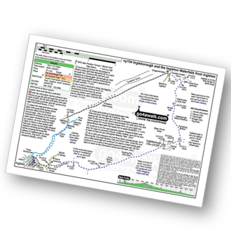
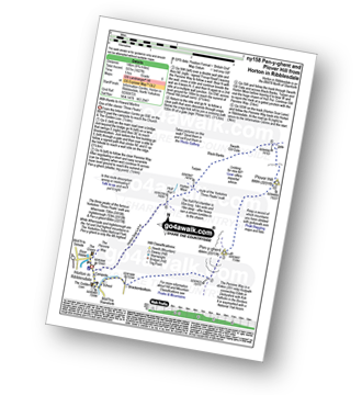
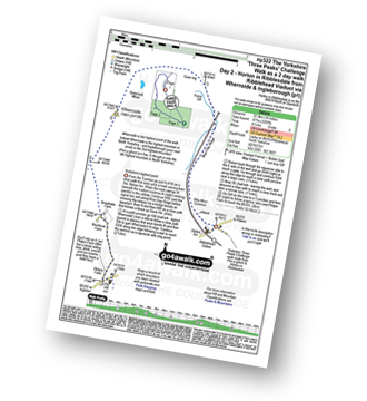
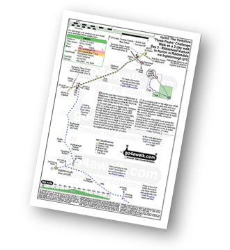
Horton in Ribblesdale - Pen-y-ghent Cafe - Brackenbottom - Gavel Rigg - The Pennine Way - Pen-y-ghent - Hunt Pot - Hull Pot - Whitber Hill - God's Bridge - Brow Gill Beck - Nether Lodge - River Ribble - Lodge Hall (or Ingman Lodge) - Ribblehead - Blea Moor - Whernside - Broadrake Farm - Chapel-le-Dale - Braithwaite Wife Hole - Ingleborough - Pen-y-ghent Cafe - Horton in Ribblesdale.
|
Vital Statistics:
| Length: | 9.5 miles (15 km) |
| Ascent: | 2,250ft (686m) |
| Time: | 5½ hrs |
| Grade: | |
Route Summary:
Ingleton - Ingleton Information Centre - Richmond House - Fell Lane - Crina Bottom Farm - Quaking Pot - Ingleborough - Little Ingleborough - Newby Moss - Newby Cote - Bleak Bank - Duck Dub - Holly Platt - Slatenber - Jenkin Bridge - Ingleton
|
Vital Statistics:
| Length: | 7.5 miles (12 km) |
| Ascent: | 876ft (267m) |
| Time: | 3½ hrs |
| Grade: | |
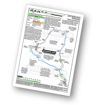
Route Summary:
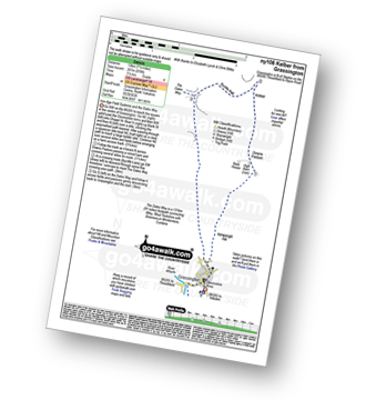
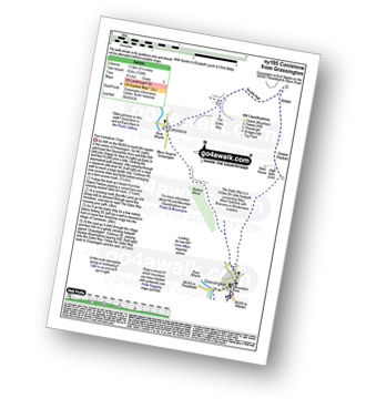
Grassington - Kimpergill Hill - Downs Pasture - Green Hill Pasture - Seeds Hill - Kelber - Bycliffe Road (Track) - The Dales Way - Old Pasture - Lea Green - Grassington
|
Vital Statistics:
| Length: | 12 miles (19 km) |
| Ascent: | 1,956ft (596m) |
| Time: | 6.25hrs |
| Grade: | |
Route Summary:
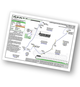
Hawes - The Pennine Way - The Herriot Way - Gayle - Gaudy Lane - Rottonstone Hill - Ten End Peat Ground - West Cam Road - Dodd Fell Hill - North Gate - West Duerley Pasture - Cam High Road - Howgate Head - Drumaldrace (Wether Fell) - Wether Fell - Gayle - Hawes
|
Vital Statistics:
| Length: | 7.75 miles (12.5 km) |
| Ascent: | 1,574ft (480m) |
| Time: | 4½ hrs |
| Grade: | |
Route Summary:
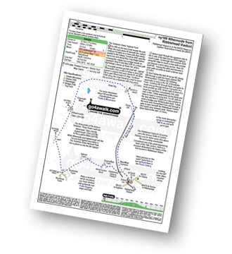
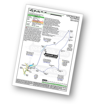
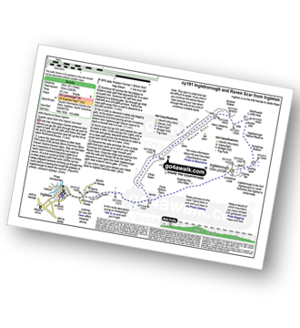
Ribblehead - Blea Moor - Force Gill - Grain Ing - Whernside - Broadrake Farm - Ivescar Farm - Ribblehead
|
Vital Statistics:
| Length: | 11.5 miles (18.5 km) |
| Ascent: | 1,017ft (310m) |
| Time: | 5.25hrs |
| Grade: | |
Route Summary:
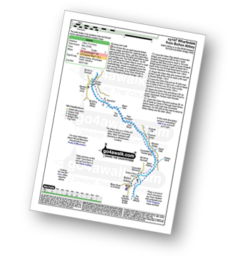
Grassington - The Dales Way - Lea Green - Old Pasture - Bycliffe Road (Track) - Kelber Gate - Kelber - Seeds Hill - Green Hill Pasture - Downs Pasture - New Pasture Edge - Yarnbury - Hebden Beck - Loss Gill Bank - Cockbur Ford - Bolton Haw Side - The Mere - Rocking Stone - Care Scar,Hole Bottom - Scale Haw - Knowles Lathe - Side Lathe - High Green - Hebden - The River Wharfe - The Dales Way - Linton Falls - Grassington
|
Vital Statistics:
| Length: | 10 miles (16 km) |
| Ascent: | 1,663ft (506m) |
| Time: | 5 hrs |
| Grade: | |
Route Summary:
Dale Head - The Pennine Way - Gavel Rigg - Pen-y-ghent - Plover Hill - Foxup Moor - Foxup Road - Low Bergh - Littondale - Pen-y-ghent Gill - Dale Head
|
Vital Statistics:
| Length: | 7.5 miles (12 km) |
| Ascent: | 909ft (277m) |
| Time: | 3.75hrs |
| Grade: | |
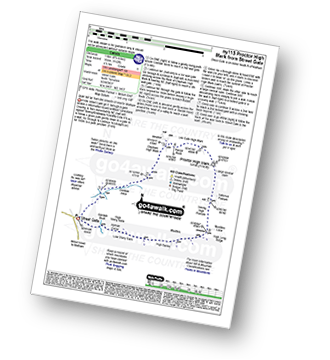
Route Summary:
Street Gate - Gordale Beck - East Great Close - Clapham High Mark - Lee Gate High Mark - Rabbit Rock - Proctor High Mark - Tommy High Pasture - Mastiles Lane - Street Gate
|
Vital Statistics:
| Length: | 16.5 miles (26 km) |
| Ascent: | 2,447ft (746m) |
| Time: | 8½ hrs |
| Grade: | |
Route Summary:
Ingleton - Thornton Hall Farm - Tow Scar - Gragareth - Green Hill (Gragareth) - Lancashire County Stone - High Pike - Kingsdale Beck - Braida Garth Farm - Twistleton Hall Farm - The Ingleton Waterfalls Trail - Beezley Falls - River Doe - Snow Falls - Ingleton
|
Vital Statistics:
| Length: | 8.5 miles (13.5 km) |
| Ascent: | 2,178ft (664m) |
| Time: | 5 hrs |
| Grade: | |
Route Summary:
Clapham - Limekiln Plantation - Clapdale Farm - Ingleborough Cave - Trow Gill - Hernal Moss - Gaping Gill - Seat Haw - Little Ingleborough - Ingleborough - Little Ingleborough - Newby Moss - Cote Haw - Newby Cote - Clapham
|
Vital Statistics:
| Length: | 9 miles (14.5 km) |
| Ascent: | 1,805ft (550m) |
| Time: | 5.25hrs |
| Grade: | |
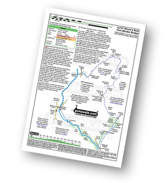
Route Summary:
Wharfedale - Barden Bridge - The River Wharfe - Wharfedale - The Dales Way - The Strid. Strid Wood - Waterfall Cottage - Posforth Gill - Valley of Desolation - Laund Pasture Plantation - Smithyman Nook - Carncliff Top (Earl Seat) - Nanny Crag - Truckle Crags - Simon's Seat (Wharfedale) - Dalehead Farm - Eastwood Head - Howgill Lodge - The Dales Way - The River Wharfe - Barden Bridge - Wharfedale
|
Vital Statistics:
| Length: | 5 miles (8 km) |
| Ascent: | 804ft (245m) |
| Time: | 2½ hrs |
| Grade: | |
Route Summary:
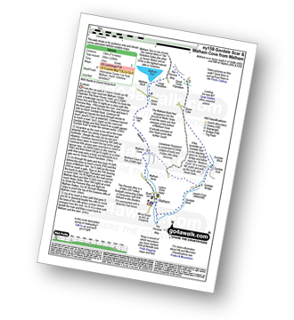
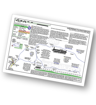
Malham - The Pennine Way - Gordale Beck - New Laithe - Mantley Field Laithe - Janet's Foss - Gordale Bridge - Gordale Scar - Gordale Bridge - Cawden Flats Barn - Shorkley Hill - Sheriff Hill - Malham Cove - Malham Beck - Malham
|
Vital Statistics:
| Length: | 12 miles (19 km) |
| Ascent: | 2,099ft (640m) |
| Time: | 6½ hrs |
| Grade: | |
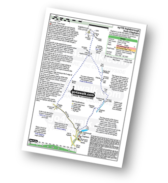
Route Summary:
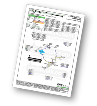
Embsay - Embsay Reservoir - Embsay Moor - Crookrise Crag Top - Waterfall Gill Beck - Rylstone Fell - Rylstone Cross - Watt Crag - Cracoe Fell - Cracoe War Memorial Cross Obelisk - Thorpe Fell Top - Upper Barden Reservoir - Embsay
|
Vital Statistics:
| Length: | 4 miles (6.5 km) |
| Ascent: | 558ft (170m) |
| Time: | 2 hrs |
| Grade: |  |
Route Summary:
Clapham - Limekiln Plantation - Clapdale Farm - Ingleborough Cave - Trow Gill - Long Lane (Track) - Thwaite Scars - Thwaite Lane (Track) - Clapham
|
Vital Statistics:
| Length: | 6.5 miles (10.5 km) |
| Ascent: | 1,476ft (450m) |
| Time: | 3.75hrs |
| Grade: | |
Route Summary:
Kettlewell - River Wharfe - New Bridge - Gate Cote Scar - Middlesmoor Pasture - Byre Bank Wood - Arncliffe - River Skirfare - Hawkswick - Knipe Wood - Kettlewell
|
Vital Statistics:
| Length: | 8.5 miles (13.5 km) |
| Ascent: | 1,653ft (504m) |
| Time: | 4.75hrs |
| Grade: | |
Route Summary:
Leck Fell House - The Three Men of Gragareth - Gragareth - Green Hill (Gragareth) - Lancashire County Stone - Great Coum - Crag Hill - Casterton Fell - Ease Gill - Leck Fell House
|
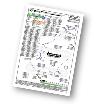
Vital Statistics:
| Length: | 8.25 miles (13 km) |
| Ascent: | 1,932ft (589m) |
| Time: | 5 hrs |
| Grade: | |
Route Summary:
Ribblehead - (The Old Hill Inn) - Chapel-le-Dale - Braithwaite Wife Hole - Ingleborough Nature Reserve - Humphrey Bottom - Ingleborough - Quaking Pot - Crina Bottom Farm - White Scars - High Howeth - Raven Scar - Harry Hallam's Moss - Old Hill Inn - Ribblehead
|
Vital Statistics:
| Length: | 6.25 miles (10 km) |
| Ascent: | 902ft (275m) |
| Time: | 3.25hrs |
| Grade: | |
Route Summary:
Street Gate - Great Close Plantation - Great Close Scar - Middle House Farm - Low Midge Hills - High Midge Hills - Middle House - Out Pasture - Middle House Hill - Dew Bottoms - Parson's Pulpit - East Great Close - Gordale Beck - Street Gate
|
Vital Statistics:
| Length: | 11.5 miles (18.5 km) |
| Ascent: | 1,961ft (598m) |
| Time: | 6.25hrs |
| Grade: | |
Route Summary:
Dale Head - The Pennine Way - Fountains Fell - Fountains Fell (South Top) - Fountains Fell Tarn - Darnbrook Fell - Wilson's Pasture - River Skirfare - Nether Hesleden Farm - Pen-y-ghent Gill - Dale Head
|
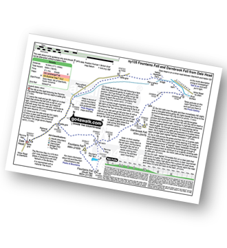
Vital Statistics:
| Length: | 12.25 miles (19.5 km) |
| Ascent: | 1,568ft (478m) |
| Time: | 6 hrs |
| Grade: | |
Route Summary:
Kingsdale - Tow Scar - Gragareth - Green Hill (Gragareth) - Lancashire County Stone - High Pike - Kingsdale Beck - Kingsdale
|
Vital Statistics:
| Length: | 6.25 miles (10 km) |
| Ascent: | 1,640ft (489m) |
| Time: | 4 hrs |
| Grade: | |
Route Summary:
Horton in Ribblesdale - Brackenbottom - Gavel Rigg - The Pennine Way - Pen-y-ghent - Hunt Pot - Hull Pot - Horton in Ribblesdale.
|
Vital Statistics:
| Length: | 10.5 miles (17 km) |
| Ascent: | 1,566ft (477m) |
| Time: | 5½ hrs |
| Grade: | |
Route Summary:
Horton In Ribblesdale - The Pennine Way - Sell Gill Holes - Sell Gill Beck - Red Moss Pot - Birkwith Moor - Birkwith Common - Green Haw Moor - Cosh Knott Well - Cosh Outside (Cosh Knott) - High Green Field Knott (Cosh Knott) - Cosh Beck Head - Lante Shop Caves - Cosh Water Gap - Black Banks - Turpen Horton Moor - Hull Pot Beck - Hull Pot - Hunt Pot - Horton Scar Lane - Horton In Ribblesdale
|
Vital Statistics:
| Length: | 7.25 miles (11.5 km) |
| Ascent: | 210ft (64m) |
| Time: | 3 hrs |
| Grade: | |
Route Summary:
Wharfedale - Bolton Abbey - The Dales Way - The River Wharfe - Wharfedale - Pickles Beck - Stead Dike - Posforth Gill - Black Sike - Bolton Abbey Aqueduct - Barden Bridge - Bolton Abbey Aqueduct - The Strid - Strid Wood - Cavendish Pavilion - Sand Holme - Bolton Priory - Bolton Abbey - Wharfedale
|
Vital Statistics:
| Length: | 3.5 miles (5.5 km) |
| Ascent: | 738ft (225m) |
| Time: | 2 hrs |
| Grade: | |
|
Vital Statistics:
| Length: | 10 miles (16 km) |
| Ascent: | 2,244ft (684m) |
| Time: | 5.75hrs |
| Grade: | |
Route Summary:
Ingleton - Fell Lane - Crina Bottom Farm - Quaking Pot - Ingleborough - Humphrey Bottom - Ingleborough Nature Reserve - Braithwaite Wife Hole - Souther Scales Farm - Chapel-le-Dale - Twistleton Scars - Oddies Lane - The Ingleton Waterfalls Trail - Beezley Falls - Snow Falls - Ingleton
|
Vital Statistics:
| Length: | 8.75 miles (14 km) |
| Ascent: | 1,827ft (557m) |
| Time: | 5 hrs |
| Grade: | |
Route Summary:
Horton In Ribblesdale - Brackenbottom - Gavel Rigg - The Pennine Way - Pen-y-ghent - Plover Hill - Foxup Moor - Swarth Gill Gate - Black Banks - Turpen - Horton Moor - Hull Pot - The Pennine Way - Horton Scar Lane - Horton In Ribblesdale
|
Vital Statistics:
| Length: | 7.5 miles (12 km) |
| Ascent: | 1,296ft (395m) |
| Time: | 4 hrs |
| Grade: | |
Route Summary:
Malham - The Pennine Way - Gordale Beck - New Laithe - Mantley Field Laithe - Janet's Foss - Gordale Bridge - Gordale Scar - New Close - Seaty Hill - Street Gate - Great Close Scar - Great Close Plantation - Malham Tarn - The Pennine Way - Malham Beck - Water Sinks - Comb Hill - Ing Scar Crag - Watlowes - Malham Cove - Malham
|
Vital Statistics:
| Length: | 11 miles (17.5 km) |
| Ascent: | 1,181ft (360m) |
| Time: | 5.25hrs |
| Grade: | |
Route Summary:
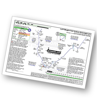
Yarnbury - Grassington Lead Mines - Duke's New Road (Track) - Hebden Beck - Cupola Corner - Deep Cut - Grassington Moor - Rather Standard Side - Sleet Moor - Rather Standard End - Henstone Band - Meugher Dike - Meugher Drive - Meugher - Friar Hood - Sandy Gate - Sandy Gate Pike Shelter - Mossdale - Mossdale Shooting Lodge - Mossdale Beck - Mossdale Scar - Bycliffe Road (Track) - Bycliffe - Kelber - Seeds Hill - Green Hill Pasture - Back Pasture - Downs Pasture - High Barn (ruin) - New Pasture Edge - Yarnbury
|
Vital Statistics:
| Length: | 8.25 miles (13 km) |
| Ascent: | 951ft (290m) |
| Time: | 3.75hrs |
| Grade: | |
Route Summary:
Clapham - Ingleborough Hall - Thwaite Lane - Summit Clump - Robin Proctor's Scar - Norber Brow - Nappa Scars - Crummack Lane - Crummack Farm - Crummack Dale - Begger's Stile - Thieves Moss - Sulber Gate - Long Scar - Long Lane (Track). Thwaite Scars - Clapham
|
Vital Statistics:
| Length: | 8.25 miles (13 km) |
| Ascent: | 1,279ft (390m) |
| Time: | 4.25hrs |
| Grade: | |
Route Summary:
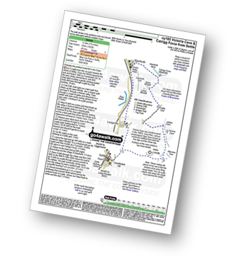
Settle - Constitution Hill - Attermire - Attermire Scar - Victoria Cave - Clay Pits Plantation - Upper Winskill - Catrigg Force (waterfall) - Stainforth - Langcliffe - Settle
|
Vital Statistics:
| Length: | 13.75 miles (22 km) |
| Ascent: | 2,660ft (811m) |
| Time: | 7½ hrs |
| Grade: | |
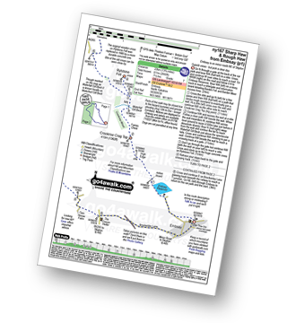
Route Summary:
Embsay - Embsay Reservoir - Embsay Moor - Crookrise Crag Top - Waterfall Gill Beck - Rylstone Fell - Rylstone Cross - Rylstone - Hetton - Flasby - Rough Haw - Sharp Haw - Embsay
|
Vital Statistics:
| Length: | 11.5 miles (18.5 km) |
| Ascent: | 2,227ft (679m) |
| Time: | 6½ hrs |
| Grade: | |
Route Summary:
Ribblehead - (The Old Hill Inn) - Ingleborough Nature Reserve - Humphrey Bottom - Ingleborough - Simon Fell - Park Fell (Ribblehead) - New Close Farm - Ribblehead - Gunnerfleet Farm - Ivescar Farm - Broadrake Farm - Ellerbeck Farm - Jingle Pot - Chaple-le-Dale - The Old Hill Inn - Ribblehead
|
Vital Statistics:
| Length: | 8.75 miles (14 km) |
| Ascent: | 1,162ft (354m) |
| Time: | 4½ hrs |
| Grade: | |
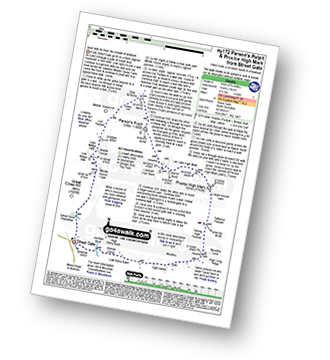
Route Summary:
Street Gate - Great Close Plantation - Great Close Scar - Middle House Farm - Low Midge Hills - High Midge Hills - Middle House - Out Pasture - Middle House Hill - Dew Bottoms - Parson's Pulpit - Lee Gate High Mark - Rabbit Rock - Proctor High Mark - Tommy High Pasture - Mastiles Lane - Street Gate
|
Vital Statistics:
| Length: | 5 miles (8 km) |
| Ascent: | 961ft (293m) |
| Time: | 3 hrs |
| Grade: | |
Route Summary:
Ingleton - Thornton Hall Farm - Kingsdale - River Dow - The Ingleton Waterfalls Trail Beezley Falls - Rival Falls - Snow Falls - Ingleton
|
Vital Statistics:
| Length: | 9.5 miles (15 km) |
| Ascent: | 2,362ft (720m) |
| Time: | 5.75hrs |
| Grade: | |
Route Summary:
Ingleton - Ingleton Tourist Information Centre - Fell Lane - Crina Bottom Farm - Quaking Pot - Ingleborough - Humphrey Bottom - Ingleborough Nature Reserve - Raven Scar - High Howeth - Harry Hallam's Moss - White Scars - Ingleton
|
Vital Statistics:
| Length: | 8.5 miles (13.5 km) |
| Ascent: | 1,158ft (353m) |
| Time: | 4.25hrs |
| Grade: | |
Route Summary:
Grassington - Kimpergill Hill - Downs Pasture - Green Hill Pasture - Seeds Hill - Kelber - Bycliffe Road (Track) - The Dales Way - Bull Scar - Davy Dimple - Conistone - Little Lathe - Dib Dale - Bastow Wood - The Dales Way - Grassington
|
Vital Statistics:
| Length: | 14 miles (22.5 km) |
| Ascent: | 2,562ft (781m) |
| Time: | 7½ hrs |
| Grade: | |
Route Summary:
Settle - Constitution Hill - Attermire Scar - Victoria Cave - Stickdale Farm - Malham - Malham Cove - Limestone Pavement - Watlowes - Langscar Gate - Outside - Gorbeck - Jubilee Cave - Clay Pits Plantation - Settle
| |
Vital Statistics:
| Length: | 4.5 miles (7 km) |
| Ascent: | 977ft (298m) |
| Time: | 2.75hrs |
| Grade: | |
Route Summary:
Settle - Constitution Hill - Attermire - Attermire Scar - Warrendale Knotts - Victoria Cave - Clay Pits Plantation - Blua Crags - Settle
|
Vital Statistics:
| Length: | 7.5 miles (12 km) |
| Ascent: | 1,492ft (455m) |
| Time: | 4½ hrs |
| Grade: | |
Route Summary:
Embsay - Embsay Reservoir - Embsay Moor - Crookrise Crag Top - Waterfall Gill Beck - Rylstone Fell - Rylstone Cross - Barden Moor - Embsay Moor - Embsay
|
Vital Statistics:
| Length: | 6.75 miles (11 km) |
| Ascent: | 607ft (185m) |
| Time: | 3.25hrs |
| Grade: | |
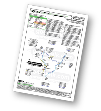
Route Summary:
Grassington - The Dales Way - Bank Lathe - Intake Lathe - Moor Lane - Hebden Beck - Loss Gill Bank - Cockbur Ford - Bolton Haw Side - The Mere - Rocking Stone - Care Scar,Hole Bottom - Scale Haw - Knowles Lathe - Side Lathe - High Green - Hebden - The River Wharfe - The Dales Way - Linton Falls - Grassington
|
Vital Statistics:
| Length: | 10.25 miles (16.5 km) |
| Ascent: | 2,136ft (651m) |
| Time: | 6 hrs |
| Grade: | |
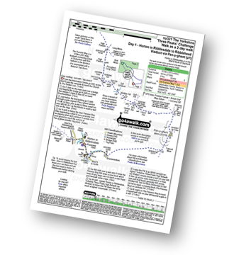
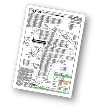
Route Summary:
Horton in Ribblesdale - Pen-y-ghent Cafe - Brackenbottom - Gavel Rigg - The Pennine Way - Pen-y-ghent - Hunt Pot - Hull Pot - Whitber Hill - God's Bridge - Brow Gill Beck - Nether Lodge - River Ribble - Lodge Hall (or Ingman Lodge) - Ribblehead - Ribblehead Railway Station - Train Journey - Horton in Ribblesdale Railway Station - Horton in Ribblesdale.
|
Vital Statistics:
| Length: | 14 miles (22.5 km) |
| Ascent: | 3,207ft (977m) |
| Time: | 8½ hrs |
| Grade: | |
Route Summary:
Horton in Ribblesdale - Railway Station - Train Journey - Ribblehead Railway Station - Ribblehead - Blea Moor - Whernside - Broadrake Farm - Ribblehead - Blea Moor - Whernside - Broadrake Farm - Chapel-le-Dale - Braithwaite Wife Hole - Ingleborough - Pen-y-ghent Cafe - Horton in Ribblesdale.
|
Vital Statistics:
| Length: | 10.25 miles (16.5 km) |
| Ascent: | 2,136ft (651m) |
| Time: | 6 hrs |
| Grade: | |
Route Summary:
Horton in Ribblesdale - Pen-y-ghent Cafe - Brackenbottom - Gavel Rigg - The Pennine Way - Pen-y-ghent - Hunt Pot - Hull Pot - Whitber Hill - God's Bridge - Brow Gill Beck - Nether Lodge - River Ribble - Lodge Hall (or Ingman Lodge) - Ribblehead - Ribblehead Railway Station - Train Journey - Horton in Ribblesdale Railway Station - Horton in Ribblesdale.
|
Vital Statistics:
| Length: | 8.75 miles (14 km) |
| Ascent: | 1,772ft (540m) |
| Time: | 5 hrs |
| Grade: | |
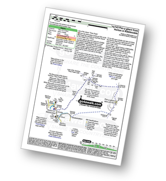
Route Summary:
Ribblehead - (Railway Station) - Blea Moor Common - Blue Clay Ridge - Force Gill - Grain Ing - Greenset Moss - Whernside - Broadrake Farm - Bruntscar Farm - Philpin Farm - Scar Close - Ellerbeck Pasture - Ribblehead
|
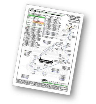
Vital Statistics:
| Length: | 9 miles (14.5 km) |
| Ascent: | 1,644ft (501m) |
| Time: | 5 hrs |
| Grade: | |
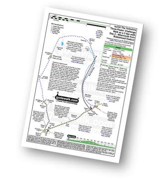
Route Summary:
Ribblehead - (Railway Station - After Train Journey From Horton in Ribblesdale) - B6255 - Old Hill Inn - Chapel-le-Dale - Braithwaite Wife Hole - Ingleborough - Pen-y-ghent Cafe - Horton in Ribblesdale.
See this list of walks, routes & maps in:
Grade Order |
Length Order |
Time Order |
Walk Number or Start Location Order
NB. To reverse (toggle) this order, click Grade Order again

To contribute to go4awalk.com or to contact us about anything at all - see Talk To Us. For help see Help.
go4awalk.com and go4awalk.co.uk are registered trademarks of TMDH Limited.
Copyright © 2000-2024 TMDH Limited. All rights reserved.
Copyright | Terms & Conditions | Privacy Statement
A - Z
Walks
Home
Log On/Accounts
Photo Gallery
Walk Ideas and Collections
Fell Facts
Places to Stay
Hill Skills
Walking Questions and Answers
Your Stories
News
Competitions
Product Reviews/Gear Tests
Walking Gear Guides
Peaks and Mountains
Peak Bagging
Find New Walking Friends
Camping
GPS Waypoints for Walking
Walk Search
Talk to us
go4awalk.com Help
Free example walks
Newsletter


