15 easy-to-follow walk, route maps of all grades on OS Explorer Map OL15 Purbeck and South Dorset
Fifteen easy-to-follow walk, route maps of all grades on OS Explorer Map OL15 Purbeck and South Dorset in Walk Grade OrderTap/mouse over a coloured circle (1-3 easy walks, 4-6 moderate walks, 7-9 hard walks) and click to select.
You can use these checkboxes to show only the grades of walk you are interested in:-
Fifteen easy-to-follow walk, route maps of all grades on OS Explorer Map OL15 Purbeck and South Dorset in Walk Grade Order
Scroll down the list of walks below & click on each walk title (in blue) to locate it on the map above.
See this list of walks, routes & maps in:
Grade Order | Length Order | Time Order | Walk Number or Start Location Order
NB. To reverse (toggle) this order, click Grade Order again
   |
Vital Statistics:
| Length: | 5.25 miles (8.5 km) |
| Ascent: | 1,234 ft (376 m) |
| Time: | 3.25 hrs |
| Grade: |  |

Route Summary:
Durdle Door Car Park - Daggers Gate - The Warren - Chaldon Down - The South West Coast Path - West Bottom - Middle Bottom - Bat's Hole - Bat's Head - The Jurassic Coast - Swyre Head - Scratchy Bottom - Durdle Door - Durdle Door Car Park
|
Vital Statistics:
| Length: | 5.5 miles (9 km) |
| Ascent: | 630 ft (192 m) |
| Time: | 2.75 hrs |
| Grade: |  |

Route Summary:
Askerswell - South Eggardon Farm - North Eggardon Farm - Eggardon Hill Fort - Eggardon Hill - Haydon Down - Stancombe Farm - Askerswell Down - Nallers Farm - Askerswell
|
Vital Statistics:
| Length: | 7.25 miles (11.5 km) |
| Ascent: | 847 ft (258 m) |
| Time: | 3½ hrs |
| Grade: | |
Route Summary:
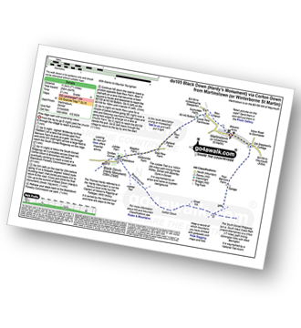
Martinstown (or Winterborne St Martin) - Four Barrows Farm - Great Hill - South Dorset Ridgeway - Corton Down - Bronkham Hill - Jubilee Trail - Blackdown - Smitten Corner - Black Down (Hardy Monument) - East Rew Farm - Rew Manor - Martinstown (or Winterboune St Martin).
|
Vital Statistics:
| Length: | 7.25 miles (11.5 km) |
| Ascent: | 643 ft (196 m) |
| Time: | 3.25 hrs |
| Grade: | |

Route Summary:
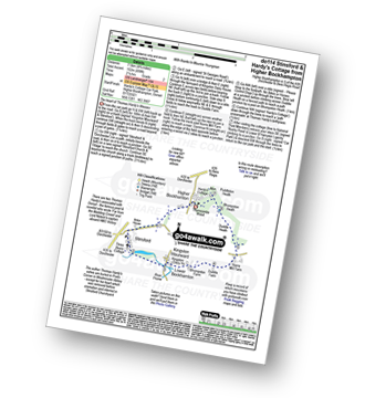
Higher Bockhampton - Stinsford - Lower Bockhampton - Kingston Maurward - River Frome - Duddle Heath - Castle Hill - Beacon Corner - Beacon Hill - Puddletown Forest - Hardy's Cottage (Thomas Hardy's Birthplace) - Higher Bockhampton
|
Vital Statistics:
| Length: | 6.25 miles (10 km) |
| Ascent: | 994 ft (303 m) |
| Time: | 3.25 hrs |
| Grade: | |

Route Summary:
Abbotsbury - The Macmillan Way - Abbotsbury Plain - The South Dorset Ridgeway - Abbotsbury Castle (Iron Age Fort) - Tulks Hill - Labour in Vain Farm - East Bexington Farm - The South West Coast Path - Chesil Beach - Abbotsbury
|
Vital Statistics:
| Length: | 4.75 miles (7.5 km) |
| Ascent: | 499 ft (152 m) |
| Time: | 2.25 hrs |
| Grade: |  |
Route Summary:
Higher Bockhampton - Stinsford - Lower Bockhampton - Kingston Maurward - Duddle Heath - Bhompston Heath - Puddleton Heath - Hardy's Cottage (Thomas Hardy's Birthplace) - Thorncombe Wood - Higher Bockhampton
|
Vital Statistics:
| Length: | 9.5 miles (15 km) |
| Ascent: | 1,388 ft (423 m) |
| Time: | 5 hrs |
| Grade: |  |

Route Summary:
Worth Matravers - Swanworth Quarry - The Purbeck Way - Coomb Bottom - Corfe Common - Corfe Castle - Corfe Common - Kingston - Houns-tout-Cliffs - The South West Coast Path - North Hill - West Hill - Renscombe Farm - Worth Matravers
|
Vital Statistics:
| Length: | 4.75 miles (7.5 km) |
| Ascent: | 811 ft (247 m) |
| Time: | 2½ hrs |
| Grade: | |

Route Summary:
West Bexington - Tulks Hill - Abbotsbury Castle (Iron Age Fort) - The South West Coast Path - Chesil Beach - West Bexington
|
Vital Statistics:
| Length: | 7 miles (11 km) |
| Ascent: | 1,037 ft (316 m) |
| Time: | 3½ hrs |
| Grade: | |

Route Summary:
Martinstown (or Winterborne St Martin) - Grove Hill Bottom - Great Hill - South Dorset Ridgeway - Corton Down - Bronkham Hill - Jubilee Trail - Blackdown - Smitten Corner - Black Down (Hardy Monument) - Bronkham Hill - Pen Barn Farm - Grove Hill Bottom - Martinstown (or Winterborne St Martin)
|
Vital Statistics:
| Length: | 9 miles (14.5 km) |
| Ascent: | 1,191 ft (363 m) |
| Time: | 4½ hrs |
| Grade: | |

Route Summary:
Lulworth Cove - West Lulworth - Durdle Door Caravan Park - Newlands Farm - Daggers Gate - The Warren - Chaldon Down - Ringstead Bay - The Jurassic Coast - The South West Coast Path - White Nothe - Whitenothe Cottage - West Bottom - Middle Bottom - Bats Hole - Bats Head - Swyre Head - Scratchy Bottom - Durdle Door - St Oswald's Bay - Hambury Tout - Dungy Head - Stair Hole - Lulworth Cove
|
Vital Statistics:
| Length: | 7.25 miles (11.5 km) |
| Ascent: | 1,158 ft (353 m) |
| Time: | 3.75 hrs |
| Grade: | |

Route Summary:
Abbotsbury - The Macmillan Way - Abbotsbury Plains - Borad Coppice - Gorwell Farm - Kingstone Russel Stone Circle - Tenants Hill - Littlebredy - Topparts Dairy - The South Dorset Ridgeway - White Hill (Abbotsbury) - Abbotsbury
|
Vital Statistics:
| Length: | 5 miles (8 km) |
| Ascent: | 561 ft (171 m) |
| Time: | 2½ hrs |
| Grade: | |
Route Summary:
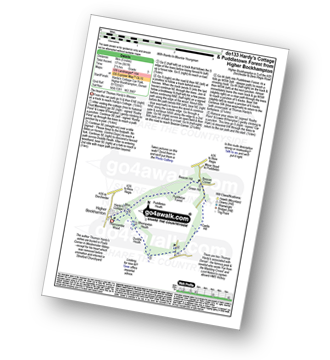
Higher Bockhampton - Thorncombe Wood - Hardy's Cottage (Thomas Hardy's Birthplace) - Bhompston Heath - Duddle Heath - Castle Hill - Beacon Corner - Beacon Hill - Puddletown Forest - Hardy's Cottage (Thomas Hardy's Birthplace) - Higher Bockhampton
|
Vital Statistics:
| Length: | 5.25 miles (8.5 km) |
| Ascent: | 322 ft (98 m) |
| Time: | 2.25 hrs |
| Grade: | |
Route Summary:
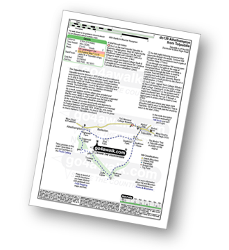
Tolpuddle - Southover Heath - Clyff Copse - Tincleton Hang - Cowpound Wood - Athelhamton - Park Farm - Tolpuddle
|
Vital Statistics:
| Length: | 8.25 miles (13 km) |
| Ascent: | 1,070 ft (326 m) |
| Time: | 4 hrs |
| Grade: | |

Route Summary:
Abbotsbury - The Macmillan Way - Abbotsbury Plain - The South Dorset Ridgeway - Abbotsbury Castle (Iron Age Fort) - Tulks Hill - West Bexington - The South West Coast Path - Chesil Beach - Abbotsbury
|
Vital Statistics:
| Length: | 4.75 miles (7.5 km) |
| Ascent: | 754 ft (230 m) |
| Time: | 2½ hrs |
| Grade: | |
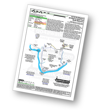
Route Summary:
Worth Matravers - The South West Coast Path - Emmetts Hill - St Aldhelm's (St Alban's) Head - St Aldhelm's Chapel - National Coastwatch Station St Alban's Head - West Man - Winspit - Winspit Bottom - Worth Matravers
See this list of walks, routes & maps in:
Grade Order | Length Order | Time Order | Walk Number or Start Location Order
NB. To reverse (toggle) this order, click Grade Order again


