Walks Routes Maps from Curbar Gap in The White Peak Area, The Peak District, Derbyshire in Walk Grade Order
Route maps for Walks that start, or go through, Curbar Gap in The White Peak Area, The Peak District, Derbyshire, England in Walk Grade Order
Details of refreshments, pubs & parking are included on each Curbar Gap walk description.
   |
Vital Statistics:
| Length: | 6.25 miles (10 km) |
| Ascent: | 1,103 ft (336 m) |
| Time: | 3½ hrs |
| Grade: |  |

Route Summary:
Birchen Edge Car Park - Jumble Coppice - Three Men - Cupola Cottage - Jack Flat - Wellington's Monument - Curbar Gap - Baslow Edge - Eagle Stone - Eaglestone Flat - Birchen Edge - Nelson's Monument (Birchen Edge) - Three Ships - Birchen Edge Car Park
|
Vital Statistics:
| Length: | 8.5 miles (13.5 km) |
| Ascent: | 896 ft (273 m) |
| Time: | 4 hrs |
| Grade: | |

Route Summary:
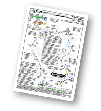
Longshaw Country Park - Woodcroft Car Park - Wooden Pole - White Edge Moor - White Edge (Big Moor) - White Edge (Big Moor) (South East Top) - Curbar Gap - Curbar Edge - Froggatt Edge - Hay Wood - Longshaw Estate - Sheffield Plantation - Longshaw Lodge - Longshaw Country Park
|
Vital Statistics:
| Length: | 7.5 miles (12 km) |
| Ascent: | 1,257 ft (383 m) |
| Time: | 4 hrs |
| Grade: | |
Route Summary:
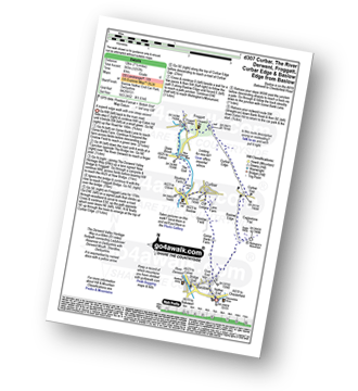
Baslow - Baslow Nether End - Baslow Over End - Gorse Bank Farm - Grislow Field Farm - Lane Farm - Curbar - The Derwent Valley Heritage Way - The River Derwent - Stocking Farm - The Goit - New Bridge - Stoke Brook - Froggatt Bridge - Froggatt - Curbar Edge - Curbar Gap - Baslow Edge - Eagle Stone - Wellington's Monument - Baslow
|
Vital Statistics:
| Length: | 10 miles (16 km) |
| Ascent: | 1,509 ft (460 m) |
| Time: | 5.25 hrs |
| Grade: |  |

Route Summary:
Baslow - Baslow Nether End - Baslow Over End - Gorse Bank Farm - Grislow Field Farm - Lane Farm - Curbar - The Derwent Valley Heritage Way - The River Derwent - Stocking Farm - The Goit - New Bridge - Stoke Brook - Froggatt Bridge - Derwent Farm - Horse Hay Coppice - Grindleford - Grindleford Church - Hay Wood - Longshaw - Froggatt Edge - Curbar Edge - Curbar Gap - Baslow Edge - Eagle Stone - Wellington's Monument - Baslow
|
Vital Statistics:
| Length: | 9.75 miles (15.5 km) |
| Ascent: | 1,001 ft (305 m) |
| Time: | 4.75 hrs |
| Grade: | |
Route Summary:
Curbar Gap - Curbar Edge - Froggatt Edge - Hay Wood - Longshaw (A621) - White Edge Lodge - White Edge Moor - Barbrook Bridge - Barbrook Reservoir - Bar Brook - Big Moor - Ramsley Moor - Ramsley Reservoir - Blake Brook - Wellington's Monument - Eagle Stone - Eaglestone Flat - Baslow Edge - Curbar Gap
|
Vital Statistics:
| Length: | 10.75 miles (17 km) |
| Ascent: | 1,493 ft (455 m) |
| Time: | 5½ hrs |
| Grade: |  |

Route Summary:
Grindleford Station - Oaks Wood - Nether Padley - White Edge Moor - Hurkling Stone - White Edge - White Edge (Big Moor) - White Edge (Big Moor) (South East Top) - Curbar Gap - Baslow Edge - Eaglestone Flat - Eagle Stone - Wellington's Monument - Over End - Baslow - The Derwent Valley Heritage Way - Bridge End - River Derwent - Bubnell - Townend Wood - St Mary's Wood - Curbar - Stocking Farm - New Bridge - Froggatt Bridge - Derwent Farm - Horse Hay Coppice - Grindleford - Grindleford Station
See more easy-to-follow circular walks in The Peak District
See more easy-to-follow circular walks in Derbyshire


