Bakewell
The White Peak Area,
The Peak District National Park,
Derbyshire, England

See views like this by using any of these 6 easy-to-follow circular walk route maps:
   |
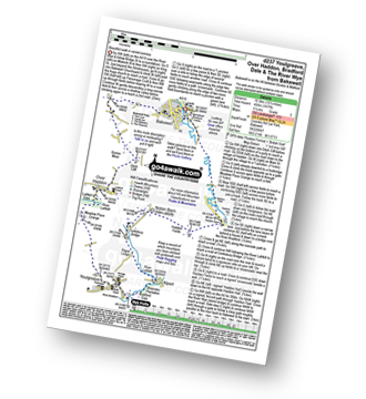
Vital Statistics:
| Length: | 4.75 miles (7.5 km) |
| Ascent: | 230ft (70m) |
| Time: | 2 hrs |
| Grade: |  |

Route Summary:
Bakewell - River Wye - Haddon Park - Haddon Hall - Haddon Fields - Wigger Dale - Burton Ashes Wood - Bakewell
|
Vital Statistics:
| Length: | 9.5 miles (15 km) |
| Ascent: | 1,332ft (406m) |
| Time: | 4.75hrs |
| Grade: |  |

Route Summary:
Bakewell - Noton Barn Farm - Noton Barn - Over Haddon - Bole Hill (Bakewell) - Kirk Dale - Sheldon - Great Shackleton Wood - River Wye - Ashford In The Water - River Wye - Holme Bridge - Bakewell
|
Vital Statistics:
| Length: | 10.25 miles (16.5 km) |
| Ascent: | 1,477ft (450m) |
| Time: | 5.25hrs |
| Grade: | |
Route Summary:
Bakewell - All Saints Church - Burton Moor - Ditch Cliff - Over Haddon - River Lathkill - Lathkill Dale - Meadow Place Grange - Youlgreave - River Bradford - Bradford Dale - River Lathkill - Lathkill Dale - Conksbury Bridge - Noton Barn - Haddon Fields - Haddon Barn - Haddon Park - River Wye - Bakewell
|
Vital Statistics:
| Length: | 9.5 miles (15 km) |
| Ascent: | 1,273ft (388m) |
| Time: | 4.75hrs |
| Grade: | |

Route Summary:
Bakewell - Castle Hill - Ballcross Farm - Edensor - River Derwent - Queen Mary's Bower - The Derwent Valley Heritage Way - Chatsworth Park - Calton Lees - Bank Wood - Rowsley - Bouns Corner - Aaron Hole Plantation - Shadyside Plantation - Haddon Park - River Wye - Wye Valley - Bakewell
|
Vital Statistics:
| Length: | 9 miles (14.5 km) |
| Ascent: | 1,257ft (383m) |
| Time: | 5 hrs |
| Grade: | |
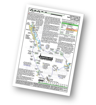
Route Summary:
Bakewell - River Wye - Haddon Park - Shadyside Plantation - Aaron Hole Plantation - Bouns Corner - Rowsley - Congreave Farm - Smithy Wood - Stanton In The Peak - Tolls Wood - Shiningbank Quarry - Haddon Fields - Wigger Dale - Burton Ashes Wood - Bakewell
|
Vital Statistics:
| Length: | 10 miles (16 km) |
| Ascent: | 1,578ft (481m) |
| Time: | 5.25hrs |
| Grade: |  |

Route Summary:
Bakewell - The Monsal Trail - Hassop Station. Great Longstone Station - Little Longstone - Monsal Head - Monsal Dale - River Wye - Great Shackleton Wood - Magpie Sough - Ashford In The Water - River Wye - Holme Bridge - Bakewell
Send us your photographs and pictures of walks and hikes in the British countryside
If you would like to see your digital photographs as part of this collection, please send them as email attachments (configured for any computer) along with your name to:
and we shall do our best to publish them.
(Guide Resolution = 300dpi. At least = 587 pixels (wide) x 440 pixels (high).)

You can also submit photos via our Facebook Page.
NB. Please indicate where each photo was taken.
NB. To see photographs and pictures from a particular walk choose your walk from Walks or use our Walk Search facility.
To see photographs and pictures on, of or from a particular Mountain, Peak, Top or Hill select from Peaks & Mountains' or enter the Mountain, Peak, Top or Hill Name into our 'Photo Search facility.

