Reach Your Peak in The Lake District with
 &
&

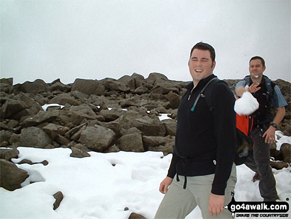
Me throwing a snowball at my mate Andy on Sca Fell
The Lake District Cumbria England
"The best place for a snowball fight....on top of Sca Fell in March!" – Simon Basford
See views like this by using any of these 7 easy-to-follow circular walk route maps:
   |
Vital Statistics:
| Length: | 10 miles (16 km) |
| Ascent: | 3,428 ft (1,045 m) |
| Time: | 7 hrs |
| Grade: |  |

Route Summary:
Eskdale - Wha House Farm - Hare Crag - Quagrigg Moss - Slight Side - Sca Fell - Symonds Knott - Foxes Tarn - Cam Spout Crag - River Esk - Great Moss - Lingcove Bridge - Brotherilkeld - Hardknott Pass - Eskdale
|
Vital Statistics:
| Length: | 10 miles (16 km) |
| Ascent: | 3,401 ft (1,037 m) |
| Time: | 7 hrs |
| Grade: | |

Route Summary:
Eskdale - Wha House Farm - Hare Crag - Goat Crag - Dawsonground Crags - Cat Crag - Quagrigg Moss - Slight Side - Sca Fell - Symonds Knott - Hard Rigg - Burnmoor Tarn - Eel Tarn - Christcliff - Wha House Farm - Eskdale
|
Vital Statistics:
| Length: | 7.5 miles (12 km) |
| Ascent: | 4,195 ft (1,279 m) |
| Time: | 7 hrs |
| Grade: | |

Route Summary:
Wasdale Head - (National Trust Campsite) - Wast Water - Lingmell - Corridor Route - Scafell Pike - Mickledore - Foxes Tarn - Symonds Knott - Sca Fell - Lingmell Gill - Wasdale Head - Wast Water.
|
Vital Statistics:
| Length: | 9.75 miles (15.5 km) |
| Ascent: | 5,140 ft (1,567 m) |
| Time: | 8.75 hrs |
| Grade: |  |

Route Summary:
Wasdale Head - (National Trust Campsite) - Wast Water - Lingmell - Middleboot Knotts - Round How (Scafell) - Great End - Ill Crag - Broad Crag - Scafell Pike - Mickledore - Foxes Tarn - Symonds Knott - Sca Fell - Wast Water.
|
Vital Statistics:
| Length: | 11 miles (17.5 km) |
| Ascent: | 5,409 ft (1,648 m) |
| Time: | 9½ hrs |
| Grade: | |

Route Summary:
Wasdale Head - (National Trust Campsite) - Wast Water - Lingmell - Corridor Route - Great End - Ill Crag - Broad Crag - Scafell Pike - Mickledore - Foxes Tarn - Symonds Knott - Sca Fell - Slight Side - Broad Tongue - Hardrigg Gill - Wasdale Head - Wast Water.
|
Vital Statistics:
| Length: | 14 miles (22.5 km) |
| Ascent: | 6,009 ft (1,832 m) |
| Time: | 9 hrs |
| Grade: |  |

Route Summary:
Eskdale - Wha House Farm - Hare Crag - Quagrigg Moss - Slight Side - Sca Fell - Symonds Knott - Mickledore - Scafell Pike - Broad Crag - Ill Crag - Great End - Esk Hause - Esk Pike - Ore Gap - Bow Fell (Bowfell) (North Top) - Bow Fell (Bowfell) - Bowfell Buttress - Cambridge Crag - Flat Crag - Climbers' Traverse (optional) - Three Tarns - Great Moss - Brotherikeld - Eskdale
|
Vital Statistics:
| Length: | 13.75 miles (22 km) |
| Ascent: | 4,982 ft (1,519 m) |
| Time: | 10 hrs |
| Grade: | |

Route Summary:
Eskdale - Wha House Farm - Hare Crag - Quagrigg Moss - Slight Side - Sca Fell - Symonds Knott - Scafell Pike - Broad Crag - Ill Crag - Great End - Esk Hause - Lingcove Bridge - Great Moss - Eskdale
Send us your photographs and pictures of walks and hikes in the British countryside
If you would like to see your digital photographs as part of this collection, please send them as email attachments (configured for any computer) along with your name to:
and we shall do our best to publish them.
(Guide Resolution = 300dpi. At least = 587 pixels (wide) x 440 pixels (high).)

You can also submit photos via our Facebook Page.
NB. Please indicate where each photo was taken.
NB. To see photographs and pictures from a particular walk choose your walk from Walks or use our Walk Search facility.
To see photographs and pictures on, of or from a particular Mountain, Peak, Top or Hill select from Peaks & Mountains' or enter the Mountain, Peak, Top or Hill Name into our 'Photo Search facility.


