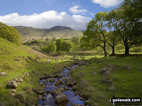
Chew Brook with Hoarstone Edge beyond from Dove Stone Reservoir
The Dark Peak Area,
The Peak District National Park,
Greater Manchester, England
See views like this by using any of these 5 easy-to-follow circular walk route maps:
   |
Vital Statistics:
| Length: | 4.5 miles (7 km) |
| Ascent: | 729ft (222m) |
| Time: | 2½ hrs |
| Grade: |  |
Route Summary:
Dove Stone Reservoir - Greenfield - The Oldham Way - Yeoman Hey Reservoir - Dove Stone Reservoir
|
Vital Statistics:
| Length: | 6.25 miles (10 km) |
| Ascent: | 1,441ft (439m) |
| Time: | 3.75hrs |
| Grade: |  |

Route Summary:
Dove Stone Reservoir - Greenfield - The Oldham Way - Yeoman Hey Reservoir - Ashway Rocks - Ashway Gap - Dean Rocks - Great Dove Stone Rocks - Dove Stone Moss - Chew Reservoir - Chew Brook - Dove Stone Reservoir
|
Vital Statistics:
| Length: | 7 miles (11 km) |
| Ascent: | 1,615ft (492m) |
| Time: | 4.25hrs |
| Grade: |  |

Route Summary:
Dove Stone Reservoir - Greenfield - The Oldham Way - Chew Brook - Chew Reservoir - Stable Stones Brow (Hoarstone Edge) - Alphin Pike - Dove Stone Reservoir
|
Vital Statistics:
| Length: | 8.5 miles (13.5 km) |
| Ascent: | 1,848ft (563m) |
| Time: | 5 hrs |
| Grade: |  |

Route Summary:
Dove Stone Reservoir - Greenfield - The Oldham Way - Yeoman Hey Reservoir - Greenfield Reservoir - Birchin Clough - Raven Stones Brow - Ashway Rocks - Ashway Gap - Dean Rocks - Great Dove Stone Rocks - Dove Stone Moss - Chew Reservoir - Chew Brook - Dove Stone Reservoir
|
Vital Statistics:
| Length: | 11.5 miles (18.5 km) |
| Ascent: | 2,501ft (762m) |
| Time: | 6.75hrs |
| Grade: |  |

Route Summary:
Dove Stone Reservoir - Greenfield - The Oldham Way - Yeoman Hey Reservoir - Greenfield Reservoir - Birchin Clough - Raven Stones Brow - Ashway Rocks - Dean Rocks - Great Dove Stone Rocks - Chew Reservoir - Stable Stones Brow (Hoarstone Edge) - Alphin Pike - Dove Stone Reservoir
Send us your photographs and pictures of walks and hikes in the British countryside
If you would like to see your digital photographs as part of this collection, please send them as email attachments (configured for any computer) along with your name to:
and we shall do our best to publish them.
(Guide Resolution = 300dpi. At least = 587 pixels (wide) x 440 pixels (high).)

You can also submit photos via our Facebook Page.
NB. Please indicate where each photo was taken.
NB. To see photographs and pictures from a particular walk choose your walk from Walks or use our Walk Search facility.
To see photographs and pictures on, of or from a particular Mountain, Peak, Top or Hill select from Peaks & Mountains' or enter the Mountain, Peak, Top or Hill Name into our 'Photo Search facility.
