
![]()
Y Lliwedd
898m (2947ft)
The Snowdon Area, Snowdonia, Gwynedd, Wales
Y Lliwedd means 'The Hue' in Welsh and is pronounced 'uh-thl-ee-weth'.
The summit of Y Lliwedd is marked by a cairn.

Not familiar with this top?
You can walk/hike to the top of Y Lliwedd by using either of these 2 easy‑to‑follow route maps:
Walk gw198 The Welsh 3000's (Snowdon Area) from Pen-y-Pass
A classic horseshoe walk - but Crib Goch is not for the faint hearted!
   |
|---|
Vital Statistics:
| Length: | 7ml (11km) |
|---|---|
| Ascent: | 3,805ft (1,160m) |
| Time: | 6.25hrs |
| Grade: |  (Moderate) (Moderate) |

Route Summary:
Pen-y-Pass - Pyg Track - Bwlch y Moch - Craig Fach - Crib Goch - Garnedd Ugain (Crib y Ddysgl) - Snowdon Mountain Railway - Snowdon (Yr Wyddfa) - The Scree Path - Bwlch y Saethau - Bwlch Ciliau - Y Lliwedd - Y Lliwedd (East Top) - Lliwedd Bach - Miners' Track - Pen-y-Pass
Walk gw136 The Snowdon (Yr Wyddfa) Horseshoe from Pen-y-Pass
A classic - but Crib Goch is not for the faint hearted!
|
|---|
Vital Statistics:
| Length: | 7.5ml (12km) |
|---|---|
| Ascent: | 4,100ft (1,250m) |
| Time: | 6½ hrs |
| Grade: |  (Hard) (Hard) |

Route Summary:
Pen-y-Pass - Pyg Track - Bwlch y Moch - Craig Fach - Crib Goch - Garnedd Ugain (Crib y Ddysgl) - Snowdon Mountain Railway - Snowdon (Yr Wyddfa) - The Scree Path - Bwlch y Saethau - Bwlch Ciliau - Y Lliwedd - Y Lliwedd (East Top) - Lliwedd Bach - Gallt y Wenallt - Afon Glaslyn - Miners' Track - Pen-y-Pass
See Y Lliwedd and the surrounding tops on our free-to-access 'Google Style' Peak Bagging Maps:
The Snowdon Area of Snowdonia National Park
Less data - quicker to download
The Whole of Snowdonia National Park
More data - might take a little longer to download
See Y Lliwedd and the surrounding tops on our unique, downloadable, PDF Peak Bagging Map:

NB: Whether you print off a copy or download it to your phone, this PDF Peak Baggers' Map might prove incredibly useful when your are up there on the tops and you cannot get a phone signal.
You can find Y Lliwedd & all the walks that climb it on these unique free-to-access Interactive Walk Planning Maps:
1:25,000 scale OS Explorer Map (orange/yellow covers):
1:50,000 scale OS Landranger Map (pink/magenta covers):
 Fellow go4awalkers who have already walked, climbed, scaled, summited, hiked & bagged Y Lliwedd
Daniel Moran walked up Y Lliwedd on December 5th, 2022 [from/via/route] Peny pas [with] Wardy [weather] Snow low wind high cloud with cloud cover - Amazing walk scramble ice axe & crampons needed
Mark Davidson climbed it on October 25th, 2016 [from/via/route] Walk gw136 The Snowdon (Yr Wyddfa) Horseshoe from Pen y Pass [with] Sub G's [weather] Rather cloudy - A classic - despite the weather
Melfyn Parry bagged it on June 15th, 2022 [from/via/route] Start point for the walk was the lay-by near Caffi Gwynant. Took Watkyn Path up to SH622516, then crossed bridge above waterfalls to continue on a path along edge of woods which eventually comes to a disused mine at SH634530. Route then indistinct but steep to gain the ridge. Path was more obvious from this point, following ridge to ascend Lliwedd Bach, continuing along to ascend Lliwedd's East & West peaks before descending back to car park down the Watkyn Path. [with] U3A [weather] Great day, mostly comfortable temperatures, cool on summits. No rain until the final descent when slight shower. - Tough ascent but great views
Donovan Suddell hiked Y Lliwedd on March 27th, 2022 [from/via/route] Pen Y Pass. Snowdon Horseshoe [with] son-in-law [weather] beautiful sunny morning.
Adrian Haywood summited on December 19th, 2021 [from/via/route] Miners path then down the watkin path from snowdon. [with] Rob [weather] Sunny
Andy Buxton conquered it during August, 1964 [from/via/route] Snowdon Horseshoe [with] Dad
Wynne Roberts scaled it on June 15th, 2019 [from/via/route] Watkin Pass [with] Gareth [weather] Sunny spells. Breezy - Came back to campsite at 10:45pm
Michael Lee has walked up Y Lliwedd [from/via/route] Pen y Pass, Pyg Track, Bwlch y Moch, Craig Fach, Crib Goch, Garnedd Ugain (Crib y Ddysgl), Snowdon Mountain Railway, Snowdon (Yr Wyddfa), The Scree Path, Bwlch y Saethau, Bwlch Ciliau, Y Lliwedd, Y Lliwedd (East Top), Lliwedd Bach, Gallt y Wenallt, Afon Glaslyn, Miners' Track, Pen y Pass. [with] Gareth & John [weather] Warm sunny - Superb day!! Sore feet!
Bleddyn Rhys climbed it on September 1st, 2011 [from/via/route] Rownd y Wyddfa - o pen y pass i Llyn Llydaw ac i fynnu'r Lliwedd cyn cario mlaen i ben y Wyddfa [with] gyda Caradog Rhys - yn 8 oed! [weather] Diwrnod braf iawn! Awyr las! - Hufen ia mawr wedyn i'r ddau ohonnom
David Wand bagged it on July 26th, 2003 [with] Gayle and the girls
Harry Meijer hiked Y Lliwedd on September 11th, 2016 [from/via/route] Penn-Y-Pass [with] The Lake District Walker
Christina Lander summited on September 5th, 2015 [from/via/route] Pen-y-pass - Crib Goch - Garnedd Ugain - Snowdon - Bwlch y Saethau - Y Lliwedd - Pen-y-pass [with] Dick [weather] Beautiful warm sunny day
Gerald Murphy conquered it on September 4th, 2014 [from/via/route] Done as part of the Snowdon Horseshow via Crib Goch. [with] Harry Chadwick [weather] Fine, sunny , dry
Robert Taylor-Marriott scaled it on February 1st, 2011 [from/via/route] Route 25: Y Lliwedd. East Top. Llewedd Bach. (LWDD) Completed 01.02.11 [with] Vince Wetton & Robert Taylor-Marriott. [weather] Cloudy, windy.
Stephen Lewis walked up Y Lliwedd on April 18th, 2014 [from/via/route] gw136, Pen-y-pass [with] Alone [weather] Hot & sunny - Horseshoe
David Lane climbed it on August 13th, 2002 [with] Kelly
Vince Wetton bagged it on February 1st, 2011 [with] RTM
Patrick Rogozinski, Mike Harris, Wendy Sockett, Angela Moroney, Louis Smith, Hugh Strickland, Anthony Jackson, Linda Mckeogh, Paul Booth, Trevor Williams, Steve Lockett, Stephen Hobdell, Kath Edwards, Chris Bede, Pete Howes, Anthony Charlson, Matthew Thomas, Steve Davenport and Victoria Bates have all walked, climbed & bagged Y Lliwedd.
To add (or remove) your name and experiences on this page - Log On and edit your Personal Mountain Bagging Record
. . . [see less walk reports]
More Photographs & Pictures of views from, on, or of, Y Lliwedd
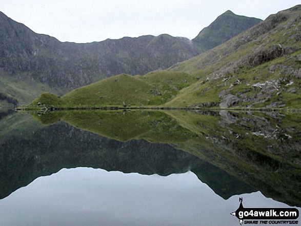
Glaslyn with the shoulder of Y Lliwedd (left) and Snowdon (Yr Wyddfa) on the right


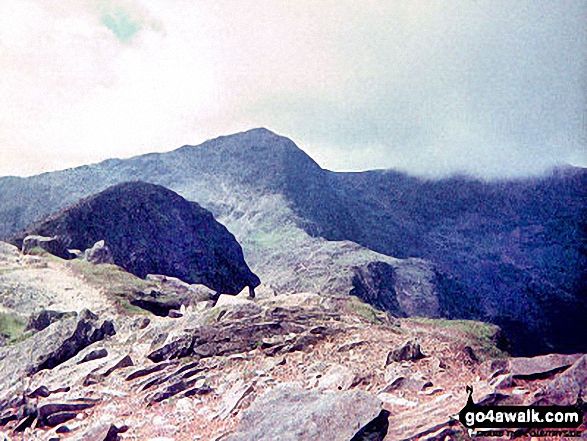

Y Lliwedd Bach (centre), Y Lliwedd (East Top) and Y Lliwedd (far right) from the north east ridge

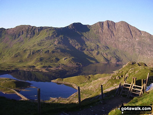
Y Lliwedd, Y Lliwedd (East Top) and Y Lliwedd Bach from the Watkin Path on Bwlch Ciliau


Garnedd Ugain (Crib y Ddysgl), Snowdon (Yr Wyddfa), Y Lliwedd & Yr Aran from the summit of Craig Cwm Silyn
. . . see all 44 walk photographs & pictures of views from, on, or of, Y Lliwedd
Send us your photographs and pictures on, of, or from Y Lliwedd
If you would like to add your walk photographs and pictures to this page, please send them as email attachments (configured for any computer) along with your name to:
and we shall do our best to publish them.
(Guide Resolution = 300dpi. At least = 660pixels (wide) x 440 pixels (high).)

You can also submit photos via our Facebook Page.
NB. Please indicate where each photo was taken and whether you wish us to credit your photos with a Username or your First Name/Last Name.


